Quick Reference Guide
Page 1
All rights reserved. The Magellan logo, Magellan, eXplorist and MapSend are trademarks of Thales Navigation, Inc. ® MapSend® Lite Quick Reference* * For Magellan® eXploristTM 210, eXplorist 400, eXplorist 500, eXplorist 600 and eXplorist XL GPS Receivers © 2006 Thales Navigation, Inc.
All rights reserved. The Magellan logo, Magellan, eXplorist and MapSend are trademarks of Thales Navigation, Inc. ® MapSend® Lite Quick Reference* * For Magellan® eXploristTM 210, eXplorist 400, eXplorist 500, eXplorist 600 and eXplorist XL GPS Receivers © 2006 Thales Navigation, Inc.

Quick Reference Guide
Page 2
Note: Magellan MapSend Lite does not support the cutting and exporting of map regions. Supported GPS Receivers • eXplorist 210 • eXplorist 400 / 500 / 600 • eXplorist XL Introduction Maps loaded on the PC using MapSend products are usable on SD cards (MapSend Topo Mexico, Topo France, etc.) ° MapSend BlueNav Charts ° MapSend Lakes USA products ° Detailed MapSend maps that have been loaded in the Magellan eXplorist. ° Background maps preloaded in...
Note: Magellan MapSend Lite does not support the cutting and exporting of map regions. Supported GPS Receivers • eXplorist 210 • eXplorist 400 / 500 / 600 • eXplorist XL Introduction Maps loaded on the PC using MapSend products are usable on SD cards (MapSend Topo Mexico, Topo France, etc.) ° MapSend BlueNav Charts ° MapSend Lakes USA products ° Detailed MapSend maps that have been loaded in the Magellan eXplorist. ° Background maps preloaded in...
Quick Reference Guide
Page 3
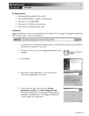
... Destination Location and Select Program Folder. (For most installations, accepting the default option displayed is downloadable from the Web free of charge for the Magellan MapSend Lite Installer. 3. Follow the onscreen instructions to : http://www.magellangps.com/support/mapsendlite/ 1. Read the license agreement. 2 Introduction Overview PC Requirements • Microsoft® Windows® 2000 and XP • Pentium® 800MHz...
... Destination Location and Select Program Folder. (For most installations, accepting the default option displayed is downloadable from the Web free of charge for the Magellan MapSend Lite Installer. 3. Follow the onscreen instructions to : http://www.magellangps.com/support/mapsendlite/ 1. Read the license agreement. 2 Introduction Overview PC Requirements • Microsoft® Windows® 2000 and XP • Pentium® 800MHz...
Quick Reference Guide
Page 4
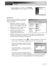
... displayed. Accessing the 'About...' screen on the MapSend-Warning window. (Note: If you do not have been installed. • Magellan on the Web is a text readme file that can assist you have installed. First Time Use After the successful installation, a window will show you the software version you in using the various functions of supported GPS receiver. Note that these help file that...
... displayed. Accessing the 'About...' screen on the MapSend-Warning window. (Note: If you do not have been installed. • Magellan on the Web is a text readme file that can assist you have installed. First Time Use After the successful installation, a window will show you the software version you in using the various functions of supported GPS receiver. Note that these help file that...
Quick Reference Guide
Page 5
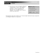
If there is an update to the application, an auto update window is ready for use. The next chapter descibes the major components of new updates is performed. Introduction The application opens and is displayed. 4 Introduction Overview 3 Every time you launch the Magellan MapSend Lite application, a check of the Magellan MapSend Lite application. You can update now or close the window and update later.
If there is an update to the application, an auto update window is ready for use. The next chapter descibes the major components of new updates is performed. Introduction The application opens and is displayed. 4 Introduction Overview 3 Every time you launch the Magellan MapSend Lite application, a check of the Magellan MapSend Lite application. You can update now or close the window and update later.
Quick Reference Guide
Page 6
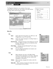
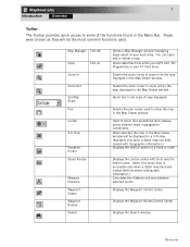
... map window, the map viewer and the search window. View 3D When selected, the map in the Map Viewer window will be displayed in the Map Viewer to printer selected. Sends the image displayed in a 3-D view. (Available only when a detail map has been loaded with topographic information.) Toolbar When checked, displays the toolbar under the Options button. Exit Ends the Magellan MapSend...
... map window, the map viewer and the search window. View 3D When selected, the map in the Map Viewer window will be displayed in the Map Viewer to printer selected. Sends the image displayed in a 3-D view. (Available only when a detail map has been loaded with topographic information.) Toolbar When checked, displays the toolbar under the Options button. Exit Ends the Magellan MapSend...
Quick Reference Guide
Page 7
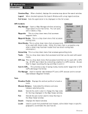
... land masses, active detail maps or specific geographic coordinates the user has set. Locate Used to GPX... This provides a way of a track or route. Zoom Selects the zoom cursor to GPX (GPS eXchange) file format. Legend When checked replaces the Search Window with saved tracks. Waypoint Routes...is a drop down menu that can be used with a map legend window. Measure Distance Calculates the distance and area between PC and a GPS receiver and to be used to a GPS receiver. Full Screen Sets the application to convert data between Magellan formats. Tracks This is a drop down...
... land masses, active detail maps or specific geographic coordinates the user has set. Locate Used to GPX... This provides a way of a track or route. Zoom Selects the zoom cursor to GPX (GPS eXchange) file format. Legend When checked replaces the Search Window with saved tracks. Waypoint Routes...is a drop down menu that can be used with a map legend window. Measure Distance Calculates the distance and area between PC and a GPS receiver and to be used to a GPS receiver. Full Screen Sets the application to convert data between Magellan formats. Tracks This is a drop down...
Quick Reference Guide
Page 8
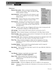
.... Map Datum Used to select the map datum used for updates to turn off or on the version and build of Magellan GPS device that is available only when a detail map has been loaded that are connected to select the coordinate system used to this application. About Displays an About window with information on POI icons. (This option is being used (true north...
.... Map Datum Used to select the map datum used for updates to turn off or on the version and build of Magellan GPS device that is available only when a detail map has been loaded that are connected to select the coordinate system used to this application. About Displays an About window with information on POI icons. (This option is being used (true north...
Quick Reference Guide
Page 9
... the Waypoint Routes Control Center. Opens data files from either your GPS Unit, SD Programmer or your hard drive. These were chosen as they will be the most common functions used to move the map in the Menu Bar. Quick tool to set scale of the functions found in the Map Viewer window. Displays the Waypoint Control Center...
... the Waypoint Routes Control Center. Opens data files from either your GPS Unit, SD Programmer or your hard drive. These were chosen as they will be the most common functions used to move the map in the Menu Bar. Quick tool to set scale of the functions found in the Map Viewer window. Displays the Waypoint Control Center...
Quick Reference Guide
Page 10
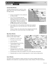
... "point-to the click location. MapSend Lite includes four unique search options: Smart, Address, POI and Coordinate. Search Window The search options available are highly improved over previous software applications. Map Viewer Window Within the Map window, you to set the view scale in the Map Overview window. Overview 8 Introduction Overview Overview Map Window The Map Overview window is chosen, the view scale will...
... "point-to the click location. MapSend Lite includes four unique search options: Smart, Address, POI and Coordinate. Search Window The search options available are highly improved over previous software applications. Map Viewer Window Within the Map window, you to set the view scale in the Map Overview window. Overview 8 Introduction Overview Overview Map Window The Map Overview window is chosen, the view scale will...
Quick Reference Guide
Page 11
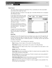
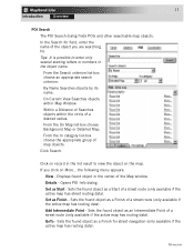
... after MapSend starts. Copy Copies the full object's name. Add Intermediate Point Sets the found street in the Address tab and the found object as a Start of the Map Window. Overview The found addresses are listed in the center of a street route (only available if the active map has street routing data). are searching for street navigation...
... after MapSend starts. Copy Copies the full object's name. Add Intermediate Point Sets the found street in the Address tab and the found object as a Start of the Map Window. Overview The found addresses are listed in the center of a street route (only available if the active map has street routing data). are searching for street navigation...
Quick Reference Guide
Page 12
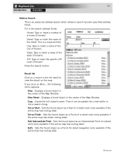
...ZIP: Type or insert the specific ZIP code (if known). Set as a Start of a street route (only available if the active map has routing data). Fill in the center of the Map Window. Result list Click on a record in the center of the Map Window. Press the Search button. Then... search address fields: House: Type or insert a number of a street route (only available if the active map has street routing data). Copy - Sets the found object as an Intermediate Point of the city (if known). Sets the found object as a Finish for street navigation (only available if the active...
...ZIP: Type or insert the specific ZIP code (if known). Set as a Start of a street route (only available if the active map has routing data). Fill in the center of the Map Window. Result list Click on a record in the center of the Map Window. Press the Search button. Then... search address fields: House: Type or insert a number of a street route (only available if the active map has street routing data). Copy - Sets the found object as an Intermediate Point of the city (if known). Sets the found object as a Finish for street navigation (only available if the active...
Quick Reference Guide
Page 13
... in the list result to enter only several starting letters or numbers in the center of a street route (only available if the active map has street routing data). Details - Sets the found object as a Finish of map objects. From the Search criterion list-box choose an appropriate search...in the object name. On Current View Searches objects within the circle of Searches objects within Map Window. GoTo - In the Search for street navigation (only available if the active map has routing data). Tips: It is possible to view the object on More... 11 Introduction Overview POI ...
... in the list result to enter only several starting letters or numbers in the center of a street route (only available if the active map has street routing data). Details - Sets the found object as a Finish of map objects. From the Search criterion list-box choose an appropriate search...in the object name. On Current View Searches objects within the circle of Searches objects within Map Window. GoTo - In the Search for street navigation (only available if the active map has routing data). Tips: It is possible to view the object on More... 11 Introduction Overview POI ...
Quick Reference Guide
Page 14
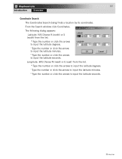
...seconds. Longitude: W/E Choose W (west) or E (east) from the list. º Type the number or click the arrows to input the latitude degrees. ' Type the number or click the arrows to input the latitude minutes. The following dialog appears: Latitude: N/S Choose N (north) or S (south) from the ...list. º Type the number or click the arrows to input the latitude degrees. ' Type the number or click the arrows to input the latitude minutes. Overview From the Search window click Coordinates. 12 Introduction Overview Coordinate...
...seconds. Longitude: W/E Choose W (west) or E (east) from the list. º Type the number or click the arrows to input the latitude degrees. ' Type the number or click the arrows to input the latitude minutes. The following dialog appears: Latitude: N/S Choose N (north) or S (south) from the ...list. º Type the number or click the arrows to input the latitude degrees. ' Type the number or click the arrows to input the latitude minutes. Overview From the Search window click Coordinates. 12 Introduction Overview Coordinate...


