Owner's Manual
Page 68
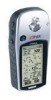
Appendix A Specifications Physical Case: Size: Weight: Temperature Range: Fully-gasketed, high-impact plastic alloy, waterproof to IPX7 standards (waterproof to one meter for 30 minutes) 4.4"H x 2"W x 1.2"D Approx. 5.3 ounces (150 g) w/batteries 5° to 158°F (-15° to 70°C) (operating) Performance Receiver: Differential-ready, 12 parallel channel Acquisition time: Approx. 15 seconds (warm start) Approx. 45 seconds (EZinit/cold start) Approx. 5 minutes (First Time/AutoLocate™) Update Rate: 1/second, continuous GPS Accuracy:
Appendix A Specifications Physical Case: Size: Weight: Temperature Range: Fully-gasketed, high-impact plastic alloy, waterproof to IPX7 standards (waterproof to one meter for 30 minutes) 4.4"H x 2"W x 1.2"D Approx. 5.3 ounces (150 g) w/batteries 5° to 158°F (-15° to 70°C) (operating) Performance Receiver: Differential-ready, 12 parallel channel Acquisition time: Approx. 15 seconds (warm start) Approx. 45 seconds (EZinit/cold start) Approx. 5 minutes (First Time/AutoLocate™) Update Rate: 1/second, continuous GPS Accuracy:

Owner's Manual
Page 69
...map and downloading them to your GARMIN dealer for MapSource details. Attaches to a slot on a belt. Carrying Holster: Allows easy access to the eTrex Vista when clipped on the bottom of waypoints and routes from a PC to an eTrex Vista. (Included) PC Interface Cable and Cigarette Lighter Power Adapter: ...) Carrying Case: Protects the eTrex Vista and permits use while in the case. Owner's Manual or Quick Start Guide (Included) PC Interface Cable: Allows for data input/output. Automotive Mounting Bracket: Can be mounted on bicycle handle bars. (Shown at www.garmin.com and THUMB on How ...
...map and downloading them to your GARMIN dealer for MapSource details. Attaches to a slot on a belt. Carrying Holster: Allows easy access to the eTrex Vista when clipped on the bottom of waypoints and routes from a PC to an eTrex Vista. (Included) PC Interface Cable and Cigarette Lighter Power Adapter: ...) Carrying Case: Protects the eTrex Vista and permits use while in the case. Owner's Manual or Quick Start Guide (Included) PC Interface Cable: Allows for data input/output. Automotive Mounting Bracket: Can be mounted on bicycle handle bars. (Shown at www.garmin.com and THUMB on How ...
Owner's Manual
Page 72
..., Roads and Recreation, and WorldMap mapping guides. Transferring MapSource Map Data If you have purchased a GARMIN MapSource™ CD-ROM mapping program you need the eTrex PC Data Cable provided with this function you may want to the eTrex Vista Data Port. To transfer data: 1. Connect the serial port connection on a PC and connected to...
..., Roads and Recreation, and WorldMap mapping guides. Transferring MapSource Map Data If you have purchased a GARMIN MapSource™ CD-ROM mapping program you need the eTrex PC Data Cable provided with this function you may want to the eTrex Vista Data Port. To transfer data: 1. Connect the serial port connection on a PC and connected to...
Owner's Manual
Page 74
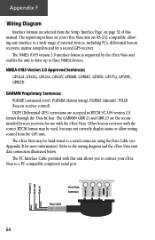
... of external devices, including PC's, differential beacon receivers, marine autopilots and /or a second GPS receiver. eTrex Vista Connector Data Cable 64 Ground (-) Data Out Data In Power (+) Ground (-) Data Out Data In Black White Green NMEA 0183 Version 3.0 Approved Sentences: GPGGA, GPGLL, GPGSA, GPGSV, GPRMB, GPRMC, GPRTE, GPVTG, GPWPL, GPBOD GARMIN Proprietary Sentences: PGRME (estimated error), PGRMM...
... of external devices, including PC's, differential beacon receivers, marine autopilots and /or a second GPS receiver. eTrex Vista Connector Data Cable 64 Ground (-) Data Out Data In Power (+) Ground (-) Data Out Data In Black White Green NMEA 0183 Version 3.0 Approved Sentences: GPGGA, GPGLL, GPGSA, GPGSV, GPRMB, GPRMC, GPRTE, GPVTG, GPWPL, GPBOD GARMIN Proprietary Sentences: PGRME (estimated error), PGRMM...
Owner's Manual
Page 76
...Route 41 Current Destination 20, 60 Current Distance 20, 60 Current ETA 20, 60 Current ETE 20, 60 Current Location 54 D D-ring 3 Data Cable 59 Data entry 2, 32 Data Fields 10, 11, 13, 16, 17, 20, 21, 22, 24, 25, 26, 27, 36, ...29 Daylight Savings Time 49 Delete Note 55 Waypoint 32 Demo Mode 53 Descent 25 Destination 20 Detail, Map 14 Differential GPS (DGPS 64 Display 51 Display Backlighting 3 Display Mode 14 Display Page 51 Distance 20, 50 Distance/Speed 50 Distance to... Intersection 38 Point of Interest 37 Waypoint 34 FIND button 2, 33 Find Menu 29, 33 G GARMIN 52 DGPS 52
...Route 41 Current Destination 20, 60 Current Distance 20, 60 Current ETA 20, 60 Current ETE 20, 60 Current Location 54 D D-ring 3 Data Cable 59 Data entry 2, 32 Data Fields 10, 11, 13, 16, 17, 20, 21, 22, 24, 25, 26, 27, 36, ...29 Daylight Savings Time 49 Delete Note 55 Waypoint 32 Demo Mode 53 Descent 25 Destination 20 Detail, Map 14 Differential GPS (DGPS 64 Display 51 Display Backlighting 3 Display Mode 14 Display Page 51 Distance 20, 50 Distance/Speed 50 Distance to... Intersection 38 Point of Interest 37 Waypoint 34 FIND button 2, 33 Find Menu 29, 33 G GARMIN 52 DGPS 52
Owner's Manual
Page 79
...Orientation 14 Overzoom 10 P PAGE button 2 Page Setup 14 Pan Map 10, 11, 12 PC Interface Cable 59 PC Interface Cable and Cigarette Lighter Power Adapter 59 Performance 58 Physical 58 Plot Over Distance 22 Plot Over Time 22 Pointer... Plots, View 23 Pressure Sensor Vent 2 Product Registration vii Profile Field 22 Projecting a Waypoint 32 R Receiver Status 5-7, 53 Renaming a Waypoint 30-32 Replacement Battery Cover 59 Reset 24, 27 Restart Search 6 Restore Defaults 11... Set course 16-20 Show Data Fields 11, 13 GPS Elevation 6, 7 Navigation Status 13 Nav Status 11 69
...Orientation 14 Overzoom 10 P PAGE button 2 Page Setup 14 Pan Map 10, 11, 12 PC Interface Cable 59 PC Interface Cable and Cigarette Lighter Power Adapter 59 Performance 58 Physical 58 Plot Over Distance 22 Plot Over Time 22 Pointer... Plots, View 23 Pressure Sensor Vent 2 Product Registration vii Profile Field 22 Projecting a Waypoint 32 R Receiver Status 5-7, 53 Renaming a Waypoint 30-32 Replacement Battery Cover 59 Reset 24, 27 Restart Search 6 Restore Defaults 11... Set course 16-20 Show Data Fields 11, 13 GPS Elevation 6, 7 Navigation Status 13 Nav Status 11 69

