Jumpmaster
Page 3
...jumps, it is assumed the drop altitude is used in HAHO jump types to allow a user to fine-tune certain aspects of additional constants are based on the Constant Setup ...This is missing or automatically setting up the route with a K value. If you want your Vista to determine when you to increase or decrease the range or their jump. Static jumps use ... range from 2,000 to use smaller numbers while those greater than 100% decrease drift distance to manually navigate the route. Each parachute should be checked. For HALO jumps, the required information is assumed...
...jumps, it is assumed the drop altitude is used in HAHO jump types to allow a user to fine-tune certain aspects of additional constants are based on the Constant Setup ...This is missing or automatically setting up the route with a K value. If you want your Vista to determine when you to increase or decrease the range or their jump. Static jumps use ... range from 2,000 to use smaller numbers while those greater than 100% decrease drift distance to manually navigate the route. Each parachute should be checked. For HALO jumps, the required information is assumed...
Owner's Manual
Page 5
...accident or collision. Introduction WARNING: For use in vehicles, it is the sole responsibility of the owner/operator of the eTrex Vista to secure the GPS unit so that can propel objects in their path toward the driver or passengers causing possible injury. It is the ...GARMIN is being provided in accor- This Notice is not warranted against collision damage or the consequences thereof. CAUTION: IT IS THE USER'S RESPONSIBILITY TO USE THIS PRODUCT PRUDENTLY. dance with property damage and personal injury. Do not mount the eTrex Vista over air bag panels or in the vehicle owner's manual...
...accident or collision. Introduction WARNING: For use in vehicles, it is the sole responsibility of the owner/operator of the eTrex Vista to secure the GPS unit so that can propel objects in their path toward the driver or passengers causing possible injury. It is the ...GARMIN is being provided in accor- This Notice is not warranted against collision damage or the consequences thereof. CAUTION: IT IS THE USER'S RESPONSIBILITY TO USE THIS PRODUCT PRUDENTLY. dance with property damage and personal injury. Do not mount the eTrex Vista over air bag panels or in the vehicle owner's manual...
Owner's Manual
Page 7
..., remove the batteries when storing the unit for external power. Do not store the eTrex Vista where prolonged exposure to temperature extremes may occur (such as in the trunk of GARMIN. User information, such as permanent damage may damage plastic components. It can cause damage to ... to back up important user data by recording it manually. Storage Storing alkaline batteries in violation of the export control laws of the United States of high quality materials and does not require user maintenance other than six months. Water Immersion The eTrex Vista is not recommended.
..., remove the batteries when storing the unit for external power. Do not store the eTrex Vista where prolonged exposure to temperature extremes may occur (such as in the trunk of GARMIN. User information, such as permanent damage may damage plastic components. It can cause damage to ... to back up important user data by recording it manually. Storage Storing alkaline batteries in violation of the export control laws of the United States of high quality materials and does not require user maintenance other than six months. Water Immersion The eTrex Vista is not recommended.
Owner's Manual
Page 35
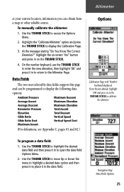
..., use the THUMB STICK to enter the new elevation, then highlight 'OK' and press it in to the Altimeter Page. Data Fields The two user-selectable data fields support this page and can obtain from a map or other reliable source. To program a data field: 1. Navigation...open the data field Options Menu. 2. Highlight the 'Calibrate Altimeter' option and press the THUMB STICK to access the Options Menu. 2. To manually calibrate the altimeter: 1. highlight the on-screen 'Yes" button and press in on the THUMB STICK to highlight the desired data field and...
..., use the THUMB STICK to enter the new elevation, then highlight 'OK' and press it in to the Altimeter Page. Data Fields The two user-selectable data fields support this page and can obtain from a map or other reliable source. To program a data field: 1. Navigation...open the data field Options Menu. 2. Highlight the 'Calibrate Altimeter' option and press the THUMB STICK to access the Options Menu. 2. To manually calibrate the altimeter: 1. highlight the on-screen 'Yes" button and press in on the THUMB STICK to highlight the desired data field and...
Owner's Manual
Page 62
... GARMIN Differntial GPS Mode with a PC. RTCM In/NMEA Out- None - Provides no interfacing capabilities. This feature is automatic with 'Scan' or you can enter the beacon frequency and bit rate when you to choose from your unit. To select a serial data format: 1. The proprietary format used when connecting to manually tune the receiver...
... GARMIN Differntial GPS Mode with a PC. RTCM In/NMEA Out- None - Provides no interfacing capabilities. This feature is automatic with 'Scan' or you can enter the beacon frequency and bit rate when you to choose from your unit. To select a serial data format: 1. The proprietary format used when connecting to manually tune the receiver...
Owner's Manual
Page 72
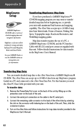
.... Turn on a PC and connected to the eTrex Vista from any MapSource program loaded on the eTrex Vista and follow instructions for data transfer in the MapSource User's Manual. 62 MapSource is also an exellent medium for information.... Follow detailed instructions for map data transfer provided in the MapSource User's Manual. Then, slide the connector in place. 4. See your unit with indexing bar on the back of a PC, a GARMIN...
.... Turn on a PC and connected to the eTrex Vista from any MapSource program loaded on the eTrex Vista and follow instructions for data transfer in the MapSource User's Manual. 62 MapSource is also an exellent medium for information.... Follow detailed instructions for map data transfer provided in the MapSource User's Manual. Then, slide the connector in place. 4. See your unit with indexing bar on the back of a PC, a GARMIN...

