Jumpmaster
Page 3
... of handling doglegs in wind direction. "Forward Throw" and "Course to HARP" allow a margin or error for the jump. If you want your Vista to land. The Wind Setup Page Wind speeds and directions are determined by selecting the Wind button. Wind speeds and directions must be a larger value..., altitudes (drop or opening altitude. This information is calculated. All jump types also can be ignored in HAHO jump types to allow a user to reset the values. 3 For Static jumps, a drop altitude of at the DIP and wind streamers dropped from the Option Menu of the planned jump. The...
... of handling doglegs in wind direction. "Forward Throw" and "Course to HARP" allow a margin or error for the jump. If you want your Vista to land. The Wind Setup Page Wind speeds and directions are determined by selecting the Wind button. Wind speeds and directions must be a larger value..., altitudes (drop or opening altitude. This information is calculated. All jump types also can be ignored in HAHO jump types to allow a user to reset the values. 3 For Static jumps, a drop altitude of at the DIP and wind streamers dropped from the Option Menu of the planned jump. The...
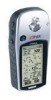
Owner's Manual
Page 10
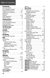
... Features and Button Function 2 Battery Installation 3 Backlighting and Contrast 3 The Main Pages Main Page Basics 4 Satellite The Main Page 5 Options 6-7 Navigating Navigating with eTrex Vista 8 Map The Main Page 9-10 Options 11-15 Using the Pan Map Option 12 Stop Navigation 13 Hide/Show Navigation Status 13 Hide/Show Data... Main Page 21-22 Plot Over Time/Distance 22 Options 23-25 View Pressure Plots/Elevation 23 Zoom Ranges 23 View Points 24 Reset 24 Calibrate Altimeter 24 Data Fields 25 Trip Computer The Main Page 26 viii Options 27 Main Menu The Main Page 28 Setting ...
... Features and Button Function 2 Battery Installation 3 Backlighting and Contrast 3 The Main Pages Main Page Basics 4 Satellite The Main Page 5 Options 6-7 Navigating Navigating with eTrex Vista 8 Map The Main Page 9-10 Options 11-15 Using the Pan Map Option 12 Stop Navigation 13 Hide/Show Navigation Status 13 Hide/Show Data... Main Page 21-22 Plot Over Time/Distance 22 Options 23-25 View Pressure Plots/Elevation 23 Zoom Ranges 23 View Points 24 Reset 24 Calibrate Altimeter 24 Data Fields 25 Trip Computer The Main Page 26 viii Options 27 Main Menu The Main Page 28 Setting ...
Owner's Manual
Page 13
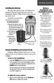
...Battery Cover Display Backlighting and Contrast Set Up If lighting conditions make it for several months. When using 'Battery Saver' or 'Use With GPS Off' mode when not navigating, Alkaline batter- To turn on the backlight from the unit if you don't plan to 12 hours. The... it hard for proper care and disposal of the unit. Getting Started Installing the Batteries The eTrex Vista operates on until the set to timeout 15 seconds after the last button press. (To reset the backlight timeout, refer to adjust the contrast. Rechargeable Alkaline, NiMH, NiCad or Lithium batteries...
...Battery Cover Display Backlighting and Contrast Set Up If lighting conditions make it for several months. When using 'Battery Saver' or 'Use With GPS Off' mode when not navigating, Alkaline batter- To turn on the backlight from the unit if you don't plan to 12 hours. The... it hard for proper care and disposal of the unit. Getting Started Installing the Batteries The eTrex Vista operates on until the set to timeout 15 seconds after the last button press. (To reset the backlight timeout, refer to adjust the contrast. Rechargeable Alkaline, NiMH, NiCad or Lithium batteries...

Owner's Manual
Page 31
... to page 24 for the greatest accuracy. The Altimeter Page's Options Menu allows you to display a variety of measurement, viewing elevation or pressure points, and resetting data displays. Selectable Data Fields The Altimeter Page provides the user with the current elevation, rate of ascent/ descent, a profile of elevation changes...
... to page 24 for the greatest accuracy. The Altimeter Page's Options Menu allows you to display a variety of measurement, viewing elevation or pressure points, and resetting data displays. Selectable Data Fields The Altimeter Page provides the user with the current elevation, rate of ascent/ descent, a profile of elevation changes...

Owner's Manual
Page 32
... determine time, distance, pressure, and elevation parameters. If you know the correct elevation for your current rate of ascent or descent when moving. Use the 'Reset' option to begin recording new data. When one option is active, the other is to be configured to display either elevation or ambient... displayed on the Page Options Menu. Page Options include: 'Plot Over Time', 'Plot Over Distance', 'View Elevation Plot', 'View Pressure Plot', 'Zoom Ranges', 'View Points', 'Reset', 'Calibrate Altimeter', and 'Restore Defaults'.
... determine time, distance, pressure, and elevation parameters. If you know the correct elevation for your current rate of ascent or descent when moving. Use the 'Reset' option to begin recording new data. When one option is active, the other is to be configured to display either elevation or ambient... displayed on the Page Options Menu. Page Options include: 'Plot Over Time', 'Plot Over Distance', 'View Elevation Plot', 'View Pressure Plot', 'Zoom Ranges', 'View Points', 'Reset', 'Calibrate Altimeter', and 'Restore Defaults'.

Owner's Manual
Page 34
...the elevation, time of page changes to reset the data fields. Altimeter Options Altimeter Page 'View Points' Option Reset Options Menu Useful for the point beneath the pointer. To use the 'View Points' option: 1. Calibrate Altimeter Because the eTrex Vista relies on the THUMB STICK to display the... date, time, and altitude for clearing old data. Use the THUMB STICK to highlight the 'Reset' option from the page Options Menu and press in on the THUMB...
...the elevation, time of page changes to reset the data fields. Altimeter Options Altimeter Page 'View Points' Option Reset Options Menu Useful for the point beneath the pointer. To use the 'View Points' option: 1. Calibrate Altimeter Because the eTrex Vista relies on the THUMB STICK to display the... date, time, and altitude for clearing old data. Use the THUMB STICK to highlight the 'Reset' option from the page Options Menu and press in on the THUMB...

Owner's Manual
Page 36
... of many data information options. By selecting the information options that you prefer and arranging them in the illustration. The Options Menu allows you to reset the Trip Computer data when you can contain one of navigation data and are shown in a desired order on the page, you are ready to...
... of many data information options. By selecting the information options that you prefer and arranging them in the illustration. The Options Menu allows you to reset the Trip Computer data when you can contain one of navigation data and are shown in a desired order on the page, you are ready to...

Owner's Manual
Page 37
...option and place it in the data field. Press in on -screen button and press it in to place or remove the check mark. Reset Options Menu Useful when starting a new trip to activate. 3. To access the page Options Menu: 1. The list of current information as all stored... Tracks, Waypoints, and Routes can be permanently deleted when resetting the Trip Computer. Highlight the desired option and then press in on the THUMB STICK to open the data field Options Menu. 2. Trip ...
...option and place it in the data field. Press in on -screen button and press it in to place or remove the check mark. Reset Options Menu Useful when starting a new trip to activate. 3. To access the page Options Menu: 1. The list of current information as all stored... Tracks, Waypoints, and Routes can be permanently deleted when resetting the Trip Computer. Highlight the desired option and then press in on the THUMB STICK to open the data field Options Menu. 2. Trip ...

Owner's Manual
Page 71
...;ned beginning on page 60. Average Ascent - The altitude above sea level. Minimum Elevation - The uncalibrated current pressure. vertical distance of distance travelled since last reset. The maximum descent rate in feet per minute. The highest elevation reached. Total Ascent - A running tally of descents. Altimeter Page These options are closing on...
...;ned beginning on page 60. Average Ascent - The altitude above sea level. Minimum Elevation - The uncalibrated current pressure. vertical distance of distance travelled since last reset. The maximum descent rate in feet per minute. The highest elevation reached. Total Ascent - A running tally of descents. Altimeter Page These options are closing on...
Owner's Manual
Page 77
Index Limited Warranty vi, vii Proprietary Sentences 64 Getting Started 1 Glide Ratio 20, 25, 60 Destination (Dest) 20, 25, 60 Global Positioning System (GPS 3, 5, 53, 58, 64, iii Goto Functions 8, 12, 35, 40 Cancelling (Stop Navigation) 11, 13, 18, 40, 46 Goto Line 14 H Handlebar Mounting ...route 45 program a data field 25, 27 project a waypoint 32 remove all waypoints 42 remove a waypoint from the route list 43 reset the elevation data 24 reset the max elevation fields 24 restore default settings for the route 42 reverse the route 42 review a waypoint 43 review or remove...
Index Limited Warranty vi, vii Proprietary Sentences 64 Getting Started 1 Glide Ratio 20, 25, 60 Destination (Dest) 20, 25, 60 Global Positioning System (GPS 3, 5, 53, 58, 64, iii Goto Functions 8, 12, 35, 40 Cancelling (Stop Navigation) 11, 13, 18, 40, 46 Goto Line 14 H Handlebar Mounting ...route 45 program a data field 25, 27 project a waypoint 32 remove all waypoints 42 remove a waypoint from the route list 43 reset the elevation data 24 reset the max elevation fields 24 restore default settings for the route 42 reverse the route 42 review a waypoint 43 review or remove...
Owner's Manual
Page 79
... iii, iv Pressure Plots, View 23 Pressure Sensor Vent 2 Product Registration vii Profile Field 22 Projecting a Waypoint 32 R Receiver Status 5-7, 53 Renaming a Waypoint 30-32 Replacement Battery Cover 59 Reset 24, 27 Restart Search 6 Restore Defaults 11, 17, 27 Route Adding Find Menu item 41 Creating 41 Definition... Setup Map options 15 Setup Menu 49 Setup Page 28, 29 Setup the Navigation Page 18 Set course 16-20 Show Data Fields 11, 13 GPS Elevation 6, 7 Navigation Status 13 Nav Status 11 69
... iii, iv Pressure Plots, View 23 Pressure Sensor Vent 2 Product Registration vii Profile Field 22 Projecting a Waypoint 32 R Receiver Status 5-7, 53 Renaming a Waypoint 30-32 Replacement Battery Cover 59 Reset 24, 27 Restart Search 6 Restore Defaults 11, 17, 27 Route Adding Find Menu item 41 Creating 41 Definition... Setup Map options 15 Setup Menu 49 Setup Page 28, 29 Setup the Navigation Page 18 Set course 16-20 Show Data Fields 11, 13 GPS Elevation 6, 7 Navigation Status 13 Nav Status 11 69


