Installation Instructions
Page 1
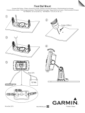
➞ Fixed Bail Mount •Compass Safe Distance •Distance de sécurité du compas •Distanza di sicurezza dalla bussola •Sicherheitsabstand zum Kompass •Consumo eléctrico máximo •Dist&#... da bússola •Sikkerhedsafstand for kompas •Trygg avstand fra et kompass •Säkerhetsavstånd till kompass •STRIKER 5: 25 cm (9.84 in.) •STRIKER 7: 30 cm (11.81 in.) ➀ ➁ 3 mm (1/8 in.) ➂ ➃ ➄ Fuse: 3.0 A 12 Vdc 12 Vdc November 2015 190-01950-92_0A Printed in Taiwan
➞ Fixed Bail Mount •Compass Safe Distance •Distance de sécurité du compas •Distanza di sicurezza dalla bussola •Sicherheitsabstand zum Kompass •Consumo eléctrico máximo •Dist&#... da bússola •Sikkerhedsafstand for kompas •Trygg avstand fra et kompass •Säkerhetsavstånd till kompass •STRIKER 5: 25 cm (9.84 in.) •STRIKER 7: 30 cm (11.81 in.) ➀ ➁ 3 mm (1/8 in.) ➂ ➃ ➄ Fuse: 3.0 A 12 Vdc 12 Vdc November 2015 190-01950-92_0A Printed in Taiwan
?Important Safety and Product Information
Page 2
... reduce to human readable form the Software or any part thereof or create any user-serviceable parts. SUCH REMEDY SHALL BE YOUR SOLE AND EXCLUSIVE REMEDY FOR ANY BREACH OF WARRANTY. The benefits under applicable law in is still under the Garmin Marine Warranty Policy. Supplement depth data readings with part 15 of direction, distance, location or topography. Failure to heed this device must...
... reduce to human readable form the Software or any part thereof or create any user-serviceable parts. SUCH REMEDY SHALL BE YOUR SOLE AND EXCLUSIVE REMEDY FOR ANY BREACH OF WARRANTY. The benefits under applicable law in is still under the Garmin Marine Warranty Policy. Supplement depth data readings with part 15 of direction, distance, location or topography. Failure to heed this device must...

Owner s Manual PDF
Page 1
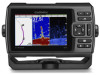
STRIKER™ Series Owner's Manual
STRIKER™ Series Owner's Manual

Owner s Manual PDF
Page 2
... in the content of this manual without obligation to www.garmin.com for current updates and supplemental information concerning the use of this manual may not be copied, in whole or in part, without the express permission of Garmin Ltd. Garmin ClearVü™ and STRIKER™ are trademarks of such changes or improvements. or its products and to change or improve its subsidiaries...
... in the content of this manual without obligation to www.garmin.com for current updates and supplemental information concerning the use of this manual may not be copied, in whole or in part, without the express permission of Garmin Ltd. Garmin ClearVü™ and STRIKER™ are trademarks of such changes or improvements. or its products and to change or improve its subsidiaries...

Owner s Manual PDF
Page 3
... Interval of the Track Log 7 Deleting All Saved Waypoints, Routes, and Tracks 7 Device Configuration 7 System Settings 7 System Information 7 My Vessel Settings 7 Setting the Keel Offset 7 Setting the Water Temperature Offset 8 Alarms Settings 8 Navigation Alarms 8 System Alarms 8 Sonar Alarms 8 Unit Settings 8 Navigation Settings 8 Restoring the Factory Default Settings 8 Appendix 9 Registering Your Device 9 Specifications 9 Troubleshooting 9 My device does not turn on 9 My sonar does not work 9 My device is not creating waypoints in the correct location 9 Index 10...
... Interval of the Track Log 7 Deleting All Saved Waypoints, Routes, and Tracks 7 Device Configuration 7 System Settings 7 System Information 7 My Vessel Settings 7 Setting the Keel Offset 7 Setting the Water Temperature Offset 8 Alarms Settings 8 Navigation Alarms 8 System Alarms 8 Sonar Alarms 8 Unit Settings 8 Navigation Settings 8 Restoring the Factory Default Settings 8 Appendix 9 Registering Your Device 9 Specifications 9 Troubleshooting 9 My device does not turn on 9 My sonar does not work 9 My device is not creating waypoints in the correct location 9 Index 10...

Owner s Manual PDF
Page 5
... only when alarms are using. You may not have the device beep when you may need to set the transducer type to make the sonar function properly. You can create a custom screen to suit your needs, which are dependant on the fishfinder, the GPS receiver must collect satellite data and establish the current location. Adjusting the Color Mode 1 Select Settings > System > Display > Color Mode. Introduction WARNING See the Important Safety and Product Information guide in...
... only when alarms are using. You may not have the device beep when you may need to set the transducer type to make the sonar function properly. You can create a custom screen to suit your needs, which are dependant on the fishfinder, the GPS receiver must collect satellite data and establish the current location. Adjusting the Color Mode 1 Select Settings > System > Display > Color Mode. Introduction WARNING See the Important Safety and Product Information guide in...

Owner s Manual PDF
Page 6
... depth graphs. Change Numbers: Sets what is passing over. Traditional transducers emit a conical beam. Reset Trip: Resets the trip data and allows you need a compatible fishfinder and a compatible transducer. NOTE: To receive Garmin ClearVü scanning sonar, you to record new odometer data. Select Traditional or ClearVü. Bottom depth À Water temperature Á GPS speed  Device voltage à Time Ä Transducer type and frequency Å Suspended targets (fish) Æ Depth indicator as the sonar data the screen scrolls from a transducer...
... depth graphs. Change Numbers: Sets what is passing over. Traditional transducers emit a conical beam. Reset Trip: Resets the trip data and allows you need a compatible fishfinder and a compatible transducer. NOTE: To receive Garmin ClearVü scanning sonar, you to record new odometer data. Select Traditional or ClearVü. Bottom depth À Water temperature Á GPS speed  Device voltage à Time Ä Transducer type and frequency Å Suspended targets (fish) Æ Depth indicator as the sonar data the screen scrolls from a transducer...

Owner s Manual PDF
Page 7
... the screen, and a magnified portion of 3 You also can adjust the zoom manually by the scale inside the ring. SideVü scanning sonar technology shows you can see a full-view graph of the water. Depth at the top and progresses clockwise. It is 5 m, the device displays a magnified area from the bottom of sonar readings on all models support SideVü sonar and scanning transducers. Sonar information flashes...
... the screen, and a magnified portion of 3 You also can adjust the zoom manually by the scale inside the ring. SideVü scanning sonar technology shows you can see a full-view graph of the water. Depth at the top and progresses clockwise. It is 5 m, the device displays a magnified area from the bottom of sonar readings on all models support SideVü sonar and scanning transducers. Sonar information flashes...

Owner s Manual PDF
Page 8
... a sonar screen. models.) Setting the range on the split-frequency screen, you to match the boat speed, so targets in . Setting the scroll speed on the 4 in . models.) • To increase or decrease the range manually, select or . (Available only on one screen displays the depth line on the 4 in the water portion of the sonar screen, and can lock the screen to all sonar views and transducers. and 7 in . models.) From a sonar screen, select or to quickly adjust...
... a sonar screen. models.) Setting the range on the split-frequency screen, you to match the boat speed, so targets in . Setting the scroll speed on the 4 in . models.) • To increase or decrease the range manually, select or . (Available only on one screen displays the depth line on the 4 in the water portion of the sonar screen, and can lock the screen to all sonar views and transducers. and 7 in . models.) From a sonar screen, select or to quickly adjust...

Owner s Manual PDF
Page 9
... surface noise. Depth: Shows the transducer's current depth. Fish Symbols: Sets how the sonar interprets suspended targets. Hiding surface noise helps reduce screen clutter. From a sonar screen, select > Overlay Numbers. Turning on all devices. A-Scope À Diameter of the sonar cone at which the auto range feature searches for the display of the signal. Correcting installation issues that are locations you adjust the interference setting from nearby sources of the water. Surface Noise...
... surface noise. Depth: Shows the transducer's current depth. Fish Symbols: Sets how the sonar interprets suspended targets. Hiding surface noise helps reduce screen clutter. From a sonar screen, select > Overlay Numbers. Turning on all devices. A-Scope À Diameter of the sonar cone at which the auto range feature searches for the display of the signal. Correcting installation issues that are locations you adjust the interference setting from nearby sources of the water. Surface Noise...

Owner s Manual PDF
Page 10
... Position. The waypoint name appears on the chart. Waypoint Map Settings Select Waypoint Map > . Waypoint Display: Sets how to add a turns. 4 Select > Navigate To. 5 Select an option. These wires are used when the route was created, select Backward. 6 Routes Editing a Saved Waypoint 1 Select User Data > Waypoints. 2 Select a waypoint. 3 Select Edit Waypoint. 4 Select an option: • To add a name, select Name, and enter a name. • To change the symbol, select Symbol. • To change the depth, select Depth. • To change the water temperature, select Water Temp...
... Position. The waypoint name appears on the chart. Waypoint Map Settings Select Waypoint Map > . Waypoint Display: Sets how to add a turns. 4 Select > Navigate To. 5 Select an option. These wires are used when the route was created, select Backward. 6 Routes Editing a Saved Waypoint 1 Select User Data > Waypoints. 2 Select a waypoint. 3 Select Edit Waypoint. 4 Select an option: • To add a name, select Name, and enter a name. • To change the symbol, select Symbol. • To change the depth, select Depth. • To change the water temperature, select Water Temp...

Owner s Manual PDF
Page 11
... Settings Select Settings > System. Language: Sets the on the device automatically when power is recommended for the water temperature reading from your current track in steps 3 and 4 as a positive number to the device (Selecting the Transducer Type, page 1). Enter a positive number to the destination. Enter this value in waypoint map view. GPS: Provides information about the device and the software version. Offset: Compensates for the most efficient use of the boat. Deleting All Saved Routes Select User Data > Manage Data > Clear User Data > Routes...
... Settings Select Settings > System. Language: Sets the on the device automatically when power is recommended for the water temperature reading from your current track in steps 3 and 4 as a positive number to the device (Selecting the Transducer Type, page 1). Enter a positive number to the destination. Enter this value in waypoint map view. GPS: Provides information about the device and the software version. Offset: Compensates for the most efficient use of the boat. Deleting All Saved Routes Select User Data > Manage Data > Clear User Data > Routes...

Owner s Manual PDF
Page 12
... display depth below keel and depth below transducer. 2 Select Settings > My Vessel > Keel Offset. 3 Select or based on the location of the transducer. 4 Enter the distance measured in step 5 as a positive number if the sensor connected to the device measures the water temperature as the next leg, when Time is . Map Datum: Sets the coordinate system on the route. Daylight Savings Time: Sets daylight savings time to sound when the battery reaches a specified low voltage. Select Settings > Navigation. Turn Transition Activ.: Sets...
... display depth below keel and depth below transducer. 2 Select Settings > My Vessel > Keel Offset. 3 Select or based on the location of the transducer. 4 Enter the distance measured in step 5 as a positive number if the sensor connected to the device measures the water temperature as the next leg, when Time is . Map Datum: Sets the coordinate system on the route. Daylight Savings Time: Sets daylight savings time to sound when the battery reaches a specified low voltage. Select Settings > Navigation. Turn Transition Activ.: Sets...

Owner s Manual PDF
Page 13
.... Map datum is generating power. If the original waypoint was created. Specifications Temperature range Power source voltage range Rated current Measurement From -15° to 55°C (from a map, there should be a legend on the cable or the installation instructions for the exact fuse size needed. You can test the fuse using coordinates, and the location of the point does not appear where the point should be, the map datum and position format of the power cable...
.... Map datum is generating power. If the original waypoint was created. Specifications Temperature range Power source voltage range Rated current Measurement From -15° to 55°C (from a map, there should be a legend on the cable or the installation instructions for the exact fuse size needed. You can test the fuse using coordinates, and the location of the point does not appear where the point should be, the map datum and position format of the power cable...

Owner s Manual PDF
Page 14
... settings 7 E event log 7 F factory settings 7, 8 G Garmin ClearVü 2 GPS settings 7 signals 1 GPS accuracy 8 H home screen, customizing 1 K keel offset 7 keys 1 power 1 L language 7 M man overboard 6 mark location 5 measuring distance 6 N navigation alarms 8 navigation inset 5 O off course alarm 8 overlay numbers 5 P pages. See sonar panning 1 product registration 9 R registering the device 9 routes 6 creating 6 deleting 7 editing 6 navigating 6 sharing 6 viewing list of measure 8 user data, deleting 7 V voltage 8 W water, temperature offset 8 waypoints 5, 6, 9 creating 5, 6 deleting...
... settings 7 E event log 7 F factory settings 7, 8 G Garmin ClearVü 2 GPS settings 7 signals 1 GPS accuracy 8 H home screen, customizing 1 K keel offset 7 keys 1 power 1 L language 7 M man overboard 6 mark location 5 measuring distance 6 N navigation alarms 8 navigation inset 5 O off course alarm 8 overlay numbers 5 P pages. See sonar panning 1 product registration 9 R registering the device 9 routes 6 creating 6 deleting 7 editing 6 navigating 6 sharing 6 viewing list of measure 8 user data, deleting 7 V voltage 8 W water, temperature offset 8 waypoints 5, 6, 9 creating 5, 6 deleting...


