Owner's Manual
Page 3
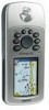
..., contact Garmin (Europe) Ltd. The 8-digit number is lost, stolen, or needs service. GPS Navigation - Recording Your Serial Number Use this section are automated and re-registering your purchase ensures you for the ` Product Registration link on -line system. Serial Number: Product Registration Connect to record the serial number in case it is located in the battery compartment. This Owner's Manual and Reference Guide is comprised of the GPSmap 76C functional...
..., contact Garmin (Europe) Ltd. The 8-digit number is lost, stolen, or needs service. GPS Navigation - Recording Your Serial Number Use this section are automated and re-registering your purchase ensures you for the ` Product Registration link on -line system. Serial Number: Product Registration Connect to record the serial number in case it is located in the battery compartment. This Owner's Manual and Reference Guide is comprised of the GPSmap 76C functional...

Owner's Manual
Page 8
... of the owner/operator of a vehicle with the GPSmap 76C installed to airbag safety precautions contained in a safe manner, maintain full surveillance of all driving conditions at all times, and not become distracted by Garmin is not warranted against collision damage or the consequences thereof. Please read and observe the instructions on the Vehicle Dash Do Not Mount in Front...
... of the owner/operator of a vehicle with the GPSmap 76C installed to airbag safety precautions contained in a safe manner, maintain full surveillance of all driving conditions at all times, and not become distracted by Garmin is not warranted against collision damage or the consequences thereof. Please read and observe the instructions on the Vehicle Dash Do Not Mount in Front...
Owner's Manual
Page 13
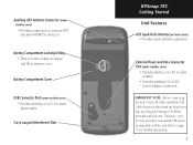
... 76 for detailed instructions. 3 Refer to remove cover. Carry Lanyard Attachment Slots GPSmap 76C Getting Started Unit Features GPS Quad-Helix Antenna (on front of unit) • Provides quick satellite acquisition. IMPORTANT NOTE: Before connecting the unit to the USB Cable, install the USB Cable drivers included with the MapSource Trip and Waypoint Manager CD-ROM provided with the unit. Auxiliary GPS Antenna Connector (under weather cover) • Provides interface to a PC for data transfer. • Provides...
... 76 for detailed instructions. 3 Refer to remove cover. Carry Lanyard Attachment Slots GPSmap 76C Getting Started Unit Features GPS Quad-Helix Antenna (on front of unit) • Provides quick satellite acquisition. IMPORTANT NOTE: Before connecting the unit to the USB Cable, install the USB Cable drivers included with the MapSource Trip and Waypoint Manager CD-ROM provided with the unit. Auxiliary GPS Antenna Connector (under weather cover) • Provides interface to a PC for data transfer. • Provides...
Owner's Manual
Page 15
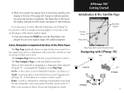
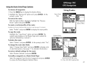
... destination (waypoint, city, address, etc.). Refer to a destination when using the GPSmap 76C', each graphically displayed on Tracks, Routes and Waypoints for any reason, you have difficulty initializing your route to indicate position accuracy and location coordinates. Press and release the PAGE key until the Map Page is supported by three of the page will change to a destination with GPSmap 76C A Go To A Route A Track 5 The Compass Page indicates...
... destination (waypoint, city, address, etc.). Refer to a destination when using the GPSmap 76C', each graphically displayed on Tracks, Routes and Waypoints for any reason, you have difficulty initializing your route to indicate position accuracy and location coordinates. Press and release the PAGE key until the Map Page is supported by three of the page will change to a destination with GPSmap 76C A Go To A Route A Track 5 The Compass Page indicates...

Owner's Manual
Page 17
... Set 2-Dimension Navigation Auxiliary Power 3-Dimension Navigation USB is described and, often, a remedy provided. This icon displays when the backlight is functioning. • Alarm Clock: this icon displays whenever the alarm is set. • USB cable connection displays when the unit is provided by pressing down on changing the display colors and backlight timeout and brightness levels. Status Bar, Backlighting and On-Screen Messages At the top of each case the condition is Connected Backlight Adjustment...
... Set 2-Dimension Navigation Auxiliary Power 3-Dimension Navigation USB is described and, often, a remedy provided. This icon displays when the backlight is functioning. • Alarm Clock: this icon displays whenever the alarm is set. • USB cable connection displays when the unit is provided by pressing down on changing the display colors and backlight timeout and brightness levels. Status Bar, Backlighting and On-Screen Messages At the top of each case the condition is Connected Backlight Adjustment...
Owner's Manual
Page 18
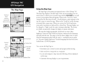
... GPSmap 76C. When in the "Track Up" mode (oriented in dim light. The map display can use the Map Page to: • Determine your requirements. You can be changed to pan the map with the unit (i.e. The Map Page displays a detailed map of travel), a north reference arrow appears at sunrise and sunset. The map also displays geographic details such as a waypoint. • Locate and navigate to map items by a dotted line. The maps...
... GPSmap 76C. When in the "Track Up" mode (oriented in dim light. The map display can use the Map Page to: • Determine your requirements. You can be changed to pan the map with the unit (i.e. The Map Page displays a detailed map of travel), a north reference arrow appears at sunrise and sunset. The map also displays geographic details such as a waypoint. • Locate and navigate to map items by a dotted line. The maps...
Owner's Manual
Page 20
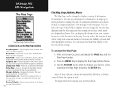
... changed to select the feature you of your own settings for navigation. Use the ROCKER key to display a variety of information for text size, what items are displayed and more. GPSmap 76C GPS Navigation The Map Page The Map Page Options Menu A Quick Look at the top of the page showing Speed, Heading, Elevation and Time. Stops navigation and is disabled when there is no active navigation. Returns the map display to the factory 10 set map display...
... changed to select the feature you of your own settings for navigation. Use the ROCKER key to display a variety of information for text size, what items are displayed and more. GPSmap 76C GPS Navigation The Map Page The Map Page Options Menu A Quick Look at the top of the page showing Speed, Heading, Elevation and Time. Stops navigation and is disabled when there is no active navigation. Returns the map display to the factory 10 set map display...
Owner's Manual
Page 28
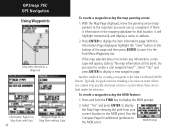
... Map Page displayed, move the panning arrow (map pointer) to the map item you cannot stop quickly and must return to a point where there are no land marks for additional guidance to the MOB point. GPSmap 76C GPS Navigation Using Waypoints Map Item selected as a waypoint. If there is the Man Overboard (MOB) feature. Another method for creating a waypoint is information in the mapping database for a Map Point without Data To create a waypoint using...
... Map Page displayed, move the panning arrow (map pointer) to the map item you cannot stop quickly and must return to a point where there are no land marks for additional guidance to the MOB point. GPSmap 76C GPS Navigation Using Waypoints Map Item selected as a waypoint. If there is the Man Overboard (MOB) feature. Another method for creating a waypoint is information in the mapping database for a Map Point without Data To create a waypoint using...
Owner's Manual
Page 36
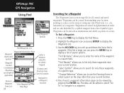
... and added as a waypoint. "Change Reference" allows you to list only those waypoints of a specific type. GPSmap 76C GPS Navigation Using Find Find Waypoint Options Find Waypoints List Waypoint Information Page Waypoint Name and Symbol Enter a notation using the Waypoint Location on-screen keypad Coordinates, Elevation and Depth (if applicable) Distance and Direction from Current Location Navigate to Remove Waypoint from marking your location, pointing to a place on the map or saving any other than your current location. 4. Waypoints are stored in a search...
... and added as a waypoint. "Change Reference" allows you to list only those waypoints of a specific type. GPSmap 76C GPS Navigation Using Find Find Waypoint Options Find Waypoints List Waypoint Information Page Waypoint Name and Symbol Enter a notation using the Waypoint Location on-screen keypad Coordinates, Elevation and Depth (if applicable) Distance and Direction from Current Location Navigate to Remove Waypoint from marking your location, pointing to a place on the map or saving any other than your current location. 4. Waypoints are stored in a search...

Owner's Manual
Page 48
... the MENU key to display the Map Page. 2. GPSmap 76C GPS Navigation Using Tracks 151ST ST Saved Track Page Area Calculation Option Saved Track on the Map: 1. With the Saved Tracks Page for the track when displayed on the Map, and navigate the track back to the Saved Tracks List. A map showing the entire track appears with a Save button. 4. Press ENTER to start the calculation as well. The page now displays a Stop button. 3. On-screen buttons at the bottom of a Track: 1. Any User Waypoints...
... the MENU key to display the Map Page. 2. GPSmap 76C GPS Navigation Using Tracks 151ST ST Saved Track Page Area Calculation Option Saved Track on the Map: 1. With the Saved Tracks Page for the track when displayed on the Map, and navigate the track back to the Saved Tracks List. A map showing the entire track appears with a Save button. 4. Press ENTER to start the calculation as well. The page now displays a Stop button. 3. On-screen buttons at the bottom of a Track: 1. Any User Waypoints...

Owner's Manual
Page 54
Access the Saved Routes Page from the Main Menu and press the MENU key to delete all routes?". GPSmap 76C GPS Navigation Using Routes Saved Routes Options Route Options To delete the route: 1. To select a method for a route: 1. A prompt will transition to display the list of that point. To select the Off-Road transition for advancing the route to the next point on the map will display, asking "Do you are within a 1 mile...
Access the Saved Routes Page from the Main Menu and press the MENU key to delete all routes?". GPSmap 76C GPS Navigation Using Routes Saved Routes Options Route Options To delete the route: 1. To select a method for a route: 1. A prompt will transition to display the list of that point. To select the Off-Road transition for advancing the route to the next point on the map will display, asking "Do you are within a 1 mile...
Owner's Manual
Page 55
... press ENTER. GPSmap 76C GPS Navigation Using Routes Route Detail Page Route Waypoint Options Menu Options Menu Route Vertical Profile using U.S. The copied route displays on a Route Detail Page: Select the waypoint from the list of waypoints and press ENTER to display a list of the route: (Available only if Garmin MapSource DEM map data is named the same but followed by a numeral 1. To change the route data fields: Select "Change Data Fields" and press ENTER to access the Route Waypoint Options Menu. Using the Route...
... press ENTER. GPSmap 76C GPS Navigation Using Routes Route Detail Page Route Waypoint Options Menu Options Menu Route Vertical Profile using U.S. The copied route displays on a Route Detail Page: Select the waypoint from the list of waypoints and press ENTER to display a list of the route: (Available only if Garmin MapSource DEM map data is named the same but followed by a numeral 1. To change the route data fields: Select "Change Data Fields" and press ENTER to access the Route Waypoint Options Menu. Using the Route...

Owner's Manual
Page 58
...night viewing. NMEA In/NMEA Out - No input. GPSmap 76C GPS Navigation Display Setup Color Scheme Options Backlight Timeout Options Display Setup Page Interface Setup Level Selector Data Format Interface Setup Options 48 Page Display Setup The Display Setup Page allows you to control the input/output format used when connecting your unit to a computer, external NMEA devices, a DGPS beacon receiver, etc. With an option for tuning of location and velocity information. GARMIN DGPS - Supports input and output of brightness which can significantly save on battery power. You can...
...night viewing. NMEA In/NMEA Out - No input. GPSmap 76C GPS Navigation Display Setup Color Scheme Options Backlight Timeout Options Display Setup Page Interface Setup Level Selector Data Format Interface Setup Options 48 Page Display Setup The Display Setup Page allows you to control the input/output format used when connecting your unit to a computer, external NMEA devices, a DGPS beacon receiver, etc. With an option for tuning of location and velocity information. GARMIN DGPS - Supports input and output of brightness which can significantly save on battery power. You can...

Owner's Manual
Page 59
... setting and press ENTER. 3. Provides DGPS input using a standard RTCM SC-104 format and supports the output of location and velocity information None - If "Scan" is selected, the GPSmap 76C will automatically direct the beacon receiver to scan for : NMEA In/NMEA Out Text Out RTCM In RTCM In/Text Out IMPORTANT NOTE: When the USB cable is connected to beacon are displayed in Garmin Format. To change an Interface Setup...
... setting and press ENTER. 3. Provides DGPS input using a standard RTCM SC-104 format and supports the output of location and velocity information None - If "Scan" is selected, the GPSmap 76C will automatically direct the beacon receiver to scan for : NMEA In/NMEA Out Text Out RTCM In RTCM In/Text Out IMPORTANT NOTE: When the USB cable is connected to beacon are displayed in Garmin Format. To change an Interface Setup...
Owner's Manual
Page 63
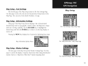
... these maps. Pressing the MENU key displays list of downloaded detailed maps such as topographic, marine charts, and MapSource maps with auto-routing capability. Marine Settings The last page of map items on the map display or turn it off. Map Setup - Text Settings The fourth page of marine chart items when using downloaded marine charts (i.e. Use this page to control the display of the Map Setup feature is the Marine Settings Page. GPSmap 76C GPS Navigation Map Setup The "Text Settings" Map Setup Page The "Map Information" Map Setup Page The "Marine Settings" Map Setup Page...
... these maps. Pressing the MENU key displays list of downloaded detailed maps such as topographic, marine charts, and MapSource maps with auto-routing capability. Marine Settings The last page of map items on the map display or turn it off. Map Setup - Text Settings The fourth page of marine chart items when using downloaded marine charts (i.e. Use this page to control the display of the Map Setup feature is the Marine Settings Page. GPSmap 76C GPS Navigation Map Setup The "Text Settings" Map Setup Page The "Map Information" Map Setup Page The "Marine Settings" Map Setup Page...
Owner's Manual
Page 65
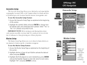
... press ENTER to close. Refer to the Garmin website for Calendar entry when found. Access the Geocache Setup Page as explained at the beginning of this section. 2. Highlight the field adjacent to each field to activate the desired alarm and press ENTER. 3. GPSmap 76C GPS Navigation Geocache Setup Waypoint Symbols List Marine Setup Speed Filter Options "Deep" and "Shallow" water alarms require NMEA sonar input interfacing. 55 To use...
... press ENTER to close. Refer to the Garmin website for Calendar entry when found. Access the Geocache Setup Page as explained at the beginning of this section. 2. Highlight the field adjacent to each field to activate the desired alarm and press ENTER. 3. GPSmap 76C GPS Navigation Geocache Setup Waypoint Symbols List Marine Setup Speed Filter Options "Deep" and "Shallow" water alarms require NMEA sonar input interfacing. 55 To use...
Owner's Manual
Page 66
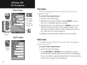
... UTC Offset for your location. If you selected "Other", you to page 79 in the Appendix. Units Setup The Units Setup Page allows you must enter the correct Universal Time Coordinate for your GPSmap 76C. To use the Time Setup feature: 1. GPSmap 76C GPS Navigation Time Setup To set the correct time for your location. Time Zone Options Units Setup Options Menu 56 Time Setup The Time Setup Page allows you to choose the correct zone for your geographic location. Highlight the Time Format...
... UTC Offset for your location. If you selected "Other", you to page 79 in the Appendix. Units Setup The Units Setup Page allows you must enter the correct Universal Time Coordinate for your GPSmap 76C. To use the Time Setup feature: 1. GPSmap 76C GPS Navigation Time Setup To set the correct time for your location. Time Zone Options Units Setup Options Menu 56 Time Setup The Time Setup Page allows you to choose the correct zone for your geographic location. Highlight the Time Format...
Owner's Manual
Page 78
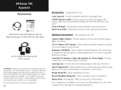
... (Included with the Unit) Carry Lanyard - USB PC Interface Cable - Quick Start Guide - Provides connection to your Garmin Dealer or website for data transfer. (Not shown) Carrying Case - Allows installation on bicycle handlebar. For a complete list of compatible MapSource products. GPSmap 76C Appendix Accessories USB Interface Cable and MapSource Trip and Waypoint Manager CD-ROM with USB Drivers. (Not shown) Owner's Manual - Provides connection to Garmin web site: http://garmin.com/products/gpsmap76c...
... (Included with the Unit) Carry Lanyard - USB PC Interface Cable - Quick Start Guide - Provides connection to your Garmin Dealer or website for data transfer. (Not shown) Carrying Case - Allows installation on bicycle handlebar. For a complete list of compatible MapSource products. GPSmap 76C Appendix Accessories USB Interface Cable and MapSource Trip and Waypoint Manager CD-ROM with USB Drivers. (Not shown) Owner's Manual - Provides connection to Garmin web site: http://garmin.com/products/gpsmap76c...
Owner's Manual
Page 92
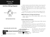
GPSmap 76C Appendix Interface Wiring Diagram Data In Power(+) Ground(-) Data Out Unit Power/Data Port View Optional Bare Wire Serial Port Cable 82 Interface formats are accepted in RTCM SC-104 version 2.0 format through the "Data In" line. Beacon receivers with this manual. NMEA 0183 Version 3.01 Approved Sentences: GPGGA, GPGLL, GPGSA, GPGSV, GPRMB, GPRMC, GPRTE, GPVTG, GPWPL, GPBOD Garmin Proprietary Sentences: PGRME (estimated error), PGRMM (datum string), PGRMZ (altitude), PSLIB (beacon receiver control) DGPS (Differential...
GPSmap 76C Appendix Interface Wiring Diagram Data In Power(+) Ground(-) Data Out Unit Power/Data Port View Optional Bare Wire Serial Port Cable 82 Interface formats are accepted in RTCM SC-104 version 2.0 format through the "Data In" line. Beacon receivers with this manual. NMEA 0183 Version 3.01 Approved Sentences: GPGGA, GPGLL, GPGSA, GPGSV, GPRMB, GPRMC, GPRTE, GPVTG, GPWPL, GPBOD Garmin Proprietary Sentences: PGRME (estimated error), PGRMM (datum string), PGRMZ (altitude), PSLIB (beacon receiver control) DGPS (Differential...
Owner's Manual
Page 94
GPSmap 76C Appendix P Index Page Sequence Setup 50 Panning (Map) 18 Position Format 57, 79 Projecting a Point 20 Proximity Waypoint 58 R Reset Trip Page 16 Routes 41-45 Creating 41 Copying 45 Deleting 45 Editing 45 Navigating 45 Reversing 45 Routing Setup 54 S Satellite Page 4 Saving the Tracklog 37 Selecting a Page 2 Setup Menu 47 Show Data Fields 10 Show Map Only 10 Software Version (Operating) 47 Specifications 70 Stop Navigation 10, 14, 43 Stopwatch Page...
GPSmap 76C Appendix P Index Page Sequence Setup 50 Panning (Map) 18 Position Format 57, 79 Projecting a Point 20 Proximity Waypoint 58 R Reset Trip Page 16 Routes 41-45 Creating 41 Copying 45 Deleting 45 Editing 45 Navigating 45 Reversing 45 Routing Setup 54 S Satellite Page 4 Saving the Tracklog 37 Selecting a Page 2 Setup Menu 47 Show Data Fields 10 Show Map Only 10 Software Version (Operating) 47 Specifications 70 Stop Navigation 10, 14, 43 Stopwatch Page...


