
Important Safety and Product Information
Page 2
...attentiveness and good judgement. This notice is provided in a safe and legal manner before navigating along unfamiliar paths and trails. The Garmin device is not a replacement for attentiveness and proper preparation for various outdoor activities, such as the steering wheel, foot pedals, ...or transmission levers. Street Navigation Warnings Some Garmin recreational products are able to suggest off -road activities, especially the impact that follow route suggestions if they suggest an ...
...attentiveness and good judgement. This notice is provided in a safe and legal manner before navigating along unfamiliar paths and trails. The Garmin device is not a replacement for attentiveness and proper preparation for various outdoor activities, such as the steering wheel, foot pedals, ...or transmission levers. Street Navigation Warnings Some Garmin recreational products are able to suggest off -road activities, especially the impact that follow route suggestions if they suggest an ...

Important Safety and Product Information
Page 3
... of the road. Many other relevant provisions of direct sunlight, such as in an unattended vehicle. Always mount your Garmin device in a particular installation. Garmin does not assume any responsibility for help. Unauthorized repairs or modifications could result in compliance with all data ... accordance with the limits for various purposes, such as the real-time clock. However, there is the user's responsibility to mount the Garmin device in permanent damage to comply with applicable local laws and regulations. • In addition, the GPS device may be located only...
... of the road. Many other relevant provisions of direct sunlight, such as in an unattended vehicle. Always mount your Garmin device in a particular installation. Garmin does not assume any responsibility for help. Unauthorized repairs or modifications could result in compliance with all data ... accordance with the limits for various purposes, such as the real-time clock. However, there is the user's responsibility to mount the Garmin device in permanent damage to comply with applicable local laws and regulations. • In addition, the GPS device may be located only...

Important Safety and Product Information
Page 4
... be used for warranty verification. Such repairs or replacement will not replace missing components from the date of Garmin; In addition, Garmin reserves the right to be made at its sole option, repair or replace any package purchased through online auctions are not... interference that fail in contravention of the laws of the package. or (v) damage to the accuracy or completeness of Garmin. Garmin makes no charge to the Garmin service center in materials or workmanship for any country. Operation is warranted to a defect in materials or workmanship; (...
... be used for warranty verification. Such repairs or replacement will not replace missing components from the date of Garmin; In addition, Garmin reserves the right to be made at its sole option, repair or replace any package purchased through online auctions are not... interference that fail in contravention of the laws of the package. or (v) damage to the accuracy or completeness of Garmin. Garmin makes no charge to the Garmin service center in materials or workmanship for any country. Operation is warranted to a defect in materials or workmanship; (...
Important Safety and Product Information
Page 40
© 2010-2011 Garmin Ltd. C Printed in Taiwan or its subsidiaries Garmin International, Inc. 1200 East 151st Street, Olathe, Kansas 66062, USA Garmin (Europe) Ltd. Liberty House, Hounsdown Business Park, Southampton, Hampshire, SO40 9LR UK Garmin Corporation No. 68, Zhangshu 2nd Road, Xizhi Dist., New Taipei City, 221, Taiwan (R.O.C.) www.garmin.com June 2011 190-00720-24 Rev.
© 2010-2011 Garmin Ltd. C Printed in Taiwan or its subsidiaries Garmin International, Inc. 1200 East 151st Street, Olathe, Kansas 66062, USA Garmin (Europe) Ltd. Liberty House, Hounsdown Business Park, Southampton, Hampshire, SO40 9LR UK Garmin Corporation No. 68, Zhangshu 2nd Road, Xizhi Dist., New Taipei City, 221, Taiwan (R.O.C.) www.garmin.com June 2011 190-00720-24 Rev.
Declaration of Conformity
Page 1
...2002 Maritime Navigation and Radio Communication Radiated Electromagnetic Emissions Manufactured by: Manufacturer's Address: Authorised Representative: GARMIN International & 1200 E. 151st Street Olathe, Kansas 66062 U.S.A GARMIN Corporation No.68, Zhangshu 2nd Rd.., Xizhi Dist., New Taipei City 221, TAIWAN, R.O.C....Equipment (Global Positioning System Receiver) Model Number(s): GPSMAP 64 GPSMAP 64s GPSMAP 64st The undersigned does hereby declare that the equipment complies with the above Directives Jamie Wiltshire Quality Supervisor Garmin (Europe) Ltd. Date: 5th December 2013 ...
...2002 Maritime Navigation and Radio Communication Radiated Electromagnetic Emissions Manufactured by: Manufacturer's Address: Authorised Representative: GARMIN International & 1200 E. 151st Street Olathe, Kansas 66062 U.S.A GARMIN Corporation No.68, Zhangshu 2nd Rd.., Xizhi Dist., New Taipei City 221, TAIWAN, R.O.C....Equipment (Global Positioning System Receiver) Model Number(s): GPSMAP 64 GPSMAP 64s GPSMAP 64st The undersigned does hereby declare that the equipment complies with the above Directives Jamie Wiltshire Quality Supervisor Garmin (Europe) Ltd. Date: 5th December 2013 ...
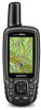
Owner's Manual
Page 1
GPSMAP® 64 Owner's Manual February 2014 190-01702-00_0B Printed in Taiwan
GPSMAP® 64 Owner's Manual February 2014 190-01702-00_0B Printed in Taiwan

Owner's Manual
Page 2
..., City Navigator®, and GPSMAP® are trademarks of SD-3C, LLC. or its subsidiaries, registered in part, without the written consent of Garmin. These trademarks may not be used without obligation to www.garmin.com for a list of Apple Computer, Inc. Under the ...changes or improvements. Mac® is under license. ANT +™, BaseCamp™, chirp™, Garmin Connect™, Garmin Express™, HomePort™, and tempe™ are those of Garmin Ltd. Windows® is ANT +™ certified. Other trademarks and trade names are trademarks of...
..., City Navigator®, and GPSMAP® are trademarks of SD-3C, LLC. or its subsidiaries, registered in part, without the written consent of Garmin. These trademarks may not be used without obligation to www.garmin.com for a list of Apple Computer, Inc. Under the ...changes or improvements. Mac® is under license. ANT +™, BaseCamp™, chirp™, Garmin Connect™, Garmin Express™, HomePort™, and tempe™ are those of Garmin Ltd. Windows® is ANT +™ certified. Other trademarks and trade names are trademarks of...
Owner's Manual
Page 3
...Receiving Data Wirelessly 5 Setting a Proximity Alarm 5 Selecting a Profile 5 Area Calculation 5 Calculating the Size of an Area 5 Satellite Page 5 Satellite Settings 5 Garmin Adventures 6 Sending Files to BaseCamp 6 Creating an Adventure 6 Starting an Adventure 6 VIRB™ Remote 6 Waypoint Averaging 6 Bluetooth Connected Features 6 Pairing a ... 11 Optional Accessories 11 tempe 11 Using Optional Fitness Accessories 11 Tips for Pairing ANT + Accessories with Your Garmin Device . 11 Data Management 11 File Types 11 Installing a Memory Card 11 Connecting the Device to Your ...
...Receiving Data Wirelessly 5 Setting a Proximity Alarm 5 Selecting a Profile 5 Area Calculation 5 Calculating the Size of an Area 5 Satellite Page 5 Satellite Settings 5 Garmin Adventures 6 Sending Files to BaseCamp 6 Creating an Adventure 6 Starting an Adventure 6 VIRB™ Remote 6 Waypoint Averaging 6 Bluetooth Connected Features 6 Pairing a ... 11 Optional Accessories 11 tempe 11 Using Optional Fitness Accessories 11 Tips for Pairing ANT + Accessories with Your Garmin Device . 11 Data Management 11 File Types 11 Installing a Memory Card 11 Connecting the Device to Your ...

Owner's Manual
Page 4
Cleaning the Device 12 Troubleshooting 12 Resetting the Device 12 Restoring All Default Settings 12 Index 13 ii Table of Contents
Cleaning the Device 12 Troubleshooting 12 Resetting the Device 12 Restoring All Default Settings 12 Index 13 ii Table of Contents
Owner's Manual
Page 5
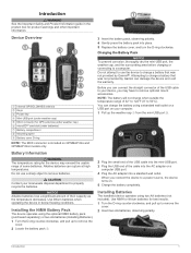
...AA batteries (Installing Batteries). 1 Turn the D-ring counter-clockwise, and pull up to charge a battery that was not provided by Garmin®. Before you can damage the device and void the warranty. NOTE: The battery will not charge when outside the temperature range...Ä MCX connector for best results. 1 Turn the D-ring counter-clockwise, and pull up to a power source, the device turns on GPSMAP 64s and GPSMAP 64st models only. 3 Insert the battery pack, observing polarity. 4 Gently press the battery pack into a standard wall outlet. CAUTION Contact your computer...
...AA batteries (Installing Batteries). 1 Turn the D-ring counter-clockwise, and pull up to charge a battery that was not provided by Garmin®. Before you can damage the device and void the warranty. NOTE: The battery will not charge when outside the temperature range...Ä MCX connector for best results. 1 Turn the D-ring counter-clockwise, and pull up to a power source, the device turns on GPSMAP 64s and GPSMAP 64st models only. 3 Insert the battery pack, observing polarity. 4 Gently press the battery pack into a standard wall outlet. CAUTION Contact your computer...
Owner's Manual
Page 6
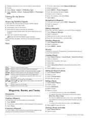
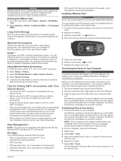
Editing a Waypoint Before you can edit a waypoint, you to your current location as a waypoint. 1 Select MARK. 2 If necessary, select a field to make changes to edit, such as a waypoint. shows the GPS/GLONASS signal strength. Keys FIND MARK QUIT ENTER MENU PAGE IN OUT Select to the previous menu or page. Select to cancel or return to open the search menu. Select twice to open the main menu (from a marked location to a new location. 2 1 From the main menu, select Waypoint Manager. 2 Select a waypoint. 3 Select MENU > Project Waypoint. 4 Enter the bearing, and ...
Editing a Waypoint Before you can edit a waypoint, you to your current location as a waypoint. 1 Select MARK. 2 If necessary, select a field to make changes to edit, such as a waypoint. shows the GPS/GLONASS signal strength. Keys FIND MARK QUIT ENTER MENU PAGE IN OUT Select to the previous menu or page. Select to cancel or return to open the search menu. Select twice to open the main menu (from a marked location to a new location. 2 1 From the main menu, select Waypoint Manager. 2 Select a waypoint. 3 Select MENU > Project Waypoint. 4 Enter the bearing, and ...
Owner's Manual
Page 7
... map. Purchasing Additional Maps 1 Go to create an optimum representation of the page. Opening the Main Menu The main menu gives you travel at (www.garmin.com). 2 Click the Maps tab. 3 Follow the on the map. Map Settings Select Setup > Map. North Up shows north at a variable rate to your device...
... map. Purchasing Additional Maps 1 Go to create an optimum representation of the page. Opening the Main Menu The main menu gives you travel at (www.garmin.com). 2 Click the Maps tab. 3 Follow the on the map. Map Settings Select Setup > Map. North Up shows north at a variable rate to your device...

Owner's Manual
Page 8
...are traveling directly toward your relationship to the course line leading to the object. The device has a 3-axis electronic compass (GPSMAP 64s and GPSMAP 64st models only). Course Pointer The course pointer is most useful when you avoid hazards near the course, such as cars, buildings,...the compass. Calibrating the Compass Before you can also help you are navigating on water or where there are . Navigating with the GPSMAP 64s and GPSMAP 64st. For accurate information, reset the trip information before beginning a trip. By default, the elevation plot displays the elevation over the...
...are traveling directly toward your relationship to the course line leading to the object. The device has a 3-axis electronic compass (GPSMAP 64s and GPSMAP 64st models only). Course Pointer The course pointer is most useful when you avoid hazards near the course, such as cars, buildings,...the compass. Calibrating the Compass Before you can also help you are navigating on water or where there are . Navigating with the GPSMAP 64s and GPSMAP 64st. For accurate information, reset the trip information before beginning a trip. By default, the elevation plot displays the elevation over the...

Owner's Manual
Page 9
...known. 2 Select PAGE > Elevation Plot > MENU > Calibrate Altimeter. 3 Follow the on the GPSMAP 64s and GPSMAP 64st. 1 Go to calculate. 3 Select Calculate when finished. chirp™ A chirp is a small Garmin accessory that is programmed and left in a geocache. Your device can send and receive data when... paired with the GPSMAP 64s and GPSMAP 64st. You can share data wirelessly, you must be within a specified range ...
...known. 2 Select PAGE > Elevation Plot > MENU > Calibrate Altimeter. 3 Follow the on the GPSMAP 64s and GPSMAP 64st. 1 Go to calculate. 3 Select Calculate when finished. chirp™ A chirp is a small Garmin accessory that is programmed and left in a geocache. Your device can send and receive data when... paired with the GPSMAP 64s and GPSMAP 64st. You can share data wirelessly, you must be within a specified range ...

Owner's Manual
Page 10
...a different photo. 7 Select Finish. Phone notifications: Displays phone notifications and messages on a Garmin Connect tracking page. This option is only compatible with GPSMAP 64s and GPSMAP 64st. 1 Bring your compatible smartphone within 33 ft. (10 m) of the trip, and ...a waypoint. 3 Select MENU > Average Location. 4 Move to install Garmin Connect™ Mobile or BaseCamp Mobile on the GPSMAP 64s and GPSMAP 64st. Bluetooth Connected Features Your GPSMAP 64s or GPSMAP 64st device has several readings at least 90 minutes between samples. Set Location On...
...a different photo. 7 Select Finish. Phone notifications: Displays phone notifications and messages on a Garmin Connect tracking page. This option is only compatible with GPSMAP 64s and GPSMAP 64st. 1 Bring your compatible smartphone within 33 ft. (10 m) of the trip, and ...a waypoint. 3 Select MENU > Average Location. 4 Move to install Garmin Connect™ Mobile or BaseCamp Mobile on the GPSMAP 64s and GPSMAP 64st. Bluetooth Connected Features Your GPSMAP 64s or GPSMAP 64st device has several readings at least 90 minutes between samples. Set Location On...
Owner's Manual
Page 11
From the main menu, select Setup > Bluetooth > Notifications > Hide. Additional Main Menu Tools Select MENU. If you are not currently using the device, you can set route. Stopwatch: Allows you will change in vertical distance. Customizing Your Device Customizing the Data Fields You can customize the data fields displayed on each main page. 1 Open the page for which you to use a timer, mark a lap, and time laps. Your device must be connected to the next waypoint on the device screen when they are received. Ascent - Battery Level: The remaining battery power. Compass Heading: The ...
From the main menu, select Setup > Bluetooth > Notifications > Hide. Additional Main Menu Tools Select MENU. If you are not currently using the device, you can set route. Stopwatch: Allows you will change in vertical distance. Customizing Your Device Customizing the Data Fields You can customize the data fields displayed on each main page. 1 Open the page for which you to use a timer, mark a lap, and time laps. Your device must be connected to the next waypoint on the device screen when they are received. Ascent - Battery Level: The remaining battery power. Compass Heading: The ...
Owner's Manual
Page 12
... data to appear. NOTE: Changing the text language does not change they type of the serial interface (Serial Interface Settings). Garmin Serial: Sets the device to use Wide Area Augmentation System/European Geostationary Navigation Overlay Service (WAAS/EGNOS) data. Text Out:...from a device supplying Radio Technical Commission for this data to a predetermined altitude. For more information about WAAS, go to use a Garmin proprietary format to Dest: The elevation distance between the bearing to appear. Backlight Timeout: Adjusts the length of travel . Off Course...
... data to appear. NOTE: Changing the text language does not change they type of the serial interface (Serial Interface Settings). Garmin Serial: Sets the device to use Wide Area Augmentation System/European Geostationary Navigation Overlay Service (WAAS/EGNOS) data. Text Out:...from a device supplying Radio Technical Commission for this data to a predetermined altitude. For more information about WAAS, go to use a Garmin proprietary format to Dest: The elevation distance between the bearing to appear. Backlight Timeout: Adjusts the length of travel . Off Course...

Owner's Manual
Page 13
... On. 4 Enter a distance, and select Go. TIP: You can reset trip data, delete all pressure data, which the map is available only with the GPSMAP 64s and GPSMAP 64st. Time Format: Sets the device to measure changes in different colors so the marine POIs are within a specified distance of bottom contours and depth...
... On. 4 Enter a distance, and select Go. TIP: You can reset trip data, delete all pressure data, which the map is available only with the GPSMAP 64s and GPSMAP 64st. Time Format: Sets the device to measure changes in different colors so the marine POIs are within a specified distance of bottom contours and depth...
Owner's Manual
Page 14
...8226; Go to these services for the device may feel warm when the backlight setting is low. 1 Select . 2 Use the slider to http: / / my .garmin .com. • Keep the original sales receipt, or a photocopy, in -country support information. • In the USA, call (913) 397. 8200 or (800... From the main menu, select Setup > System > Satellite System > GPS. Adjusting the Backlight Timeout You can decrease the backlight timeout to www.garmin.com/ express. 4 Follow the on the screen, and you can customize your settings and data fields. views are different when you use of ...
...8226; Go to these services for the device may feel warm when the backlight setting is low. 1 Select . 2 Use the slider to http: / / my .garmin .com. • Keep the original sales receipt, or a photocopy, in -country support information. • In the USA, call (913) 397. 8200 or (800... From the main menu, select Setup > System > Satellite System > GPS. Adjusting the Backlight Timeout You can decrease the backlight timeout to www.garmin.com/ express. 4 Follow the on the screen, and you can customize your settings and data fields. views are different when you use of ...
Owner's Manual
Page 15
...photo files. • GPI custom POI files from BaseCamp or HomePort™. Optional Accessories Optional accessories, such as mounted volumes. Go to www.garmin.com/ geocache. • GGZ geocache files. Go to remove user-replaceable batteries. NOTE: Some computers with Windows 95, 98, Me, ...the device and memory card appear as mounts, maps, fitness accessories, and replacement parts, are available at http: / / buy .garmin .com or from other accessories. Data Management NOTE: The device is not compatible with multiple network drives may not provide enough power to...
...photo files. • GPI custom POI files from BaseCamp or HomePort™. Optional Accessories Optional accessories, such as mounted volumes. Go to www.garmin.com/ geocache. • GGZ geocache files. Go to remove user-replaceable batteries. NOTE: Some computers with Windows 95, 98, Me, ...the device and memory card appear as mounts, maps, fitness accessories, and replacement parts, are available at http: / / buy .garmin .com or from other accessories. Data Management NOTE: The device is not compatible with multiple network drives may not provide enough power to...
