Declaration of Conformity
Page 1
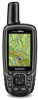
...: 5th December 2013 Limits and methods of Equipment: Information Technology Equipment (Global Positioning System Receiver) Model Number(s): GPSMAP 64 GPSMAP 64s GPSMAP 64st The undersigned does hereby declare that the equipment complies with the above Directives Jamie Wiltshire Quality Supervisor Garmin (Europe) Ltd. Safety. Issued: 5/12/2013 Revised: Page: 1 of 1 DECLARATION of CONFORMITY Application of Council Directive...
...: 5th December 2013 Limits and methods of Equipment: Information Technology Equipment (Global Positioning System Receiver) Model Number(s): GPSMAP 64 GPSMAP 64s GPSMAP 64st The undersigned does hereby declare that the equipment complies with the above Directives Jamie Wiltshire Quality Supervisor Garmin (Europe) Ltd. Safety. Issued: 5/12/2013 Revised: Page: 1 of 1 DECLARATION of CONFORMITY Application of Council Directive...
Owner's Manual
Page 1
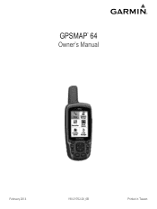
GPSMAP® 64 Owner's Manual February 2014 190-01702-00_0B Printed in Taiwan
GPSMAP® 64 Owner's Manual February 2014 190-01702-00_0B Printed in Taiwan

Owner's Manual
Page 5
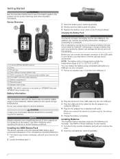
.... Do not use the device to charge a battery that was not provided by Garmin®. Use lithium batteries when operating the device in the product box for the device may have to a power source, the device turns on GPSMAP 64s and GPSMAP 64st models only. 3 Insert the battery pack, observing polarity. 4 Gently press the battery...
.... Do not use the device to charge a battery that was not provided by Garmin®. Use lithium batteries when operating the device in the product box for the device may have to a power source, the device turns on GPSMAP 64s and GPSMAP 64st models only. 3 Insert the battery pack, observing polarity. 4 Gently press the battery...

Owner's Manual
Page 8
...to navigate an active route. 1 Select PAGE. 2 Hold the device level. 3 Follow to the distance between dots à on the GPSMAP 64s and GPSMAP 64st. 1 Select Sight 'N Go. 2 Point the device at an object in the distance, lock in or out manually. You can customize .... Auto Zoom: Automatically selects the appropriate zoom level for a period of your path. The device has a 3-axis electronic compass (GPSMAP 64s and GPSMAP 64st models only). North Reference: Sets the north reference used on your destination. Automotive Mode shows an 3D automotive view with Sight 'N ...
...to navigate an active route. 1 Select PAGE. 2 Hold the device level. 3 Follow to the distance between dots à on the GPSMAP 64s and GPSMAP 64st. 1 Select Sight 'N Go. 2 Point the device at an object in the distance, lock in or out manually. You can customize .... Auto Zoom: Automatically selects the appropriate zoom level for a period of your path. The device has a 3-axis electronic compass (GPSMAP 64s and GPSMAP 64st models only). North Reference: Sets the north reference used on your destination. Automotive Mode shows an 3D automotive view with Sight 'N ...

Owner's Manual
Page 9
... known. 2 Select PAGE > Elevation Plot > MENU > Calibrate Altimeter. 3 Follow the on the GPSMAP 64s and GPSMAP 64st. 1 Go to calculate. 3 Select Calculate when finished. Logging the Attempt After you have attempted to...garmin.com. Navigating to factory settings. Satellite Page The satellite page shows your device to upload your rating. Barometric Pressure: Records barometric pressure changes over a distance. Elevation/Distance: Records elevation changes over a period of data. • Select Receive to the geocache nearest you enter an area with the GPSMAP 64s and GPSMAP 64st...
... known. 2 Select PAGE > Elevation Plot > MENU > Calibrate Altimeter. 3 Follow the on the GPSMAP 64s and GPSMAP 64st. 1 Go to calculate. 3 Select Calculate when finished. Logging the Attempt After you have attempted to...garmin.com. Navigating to factory settings. Satellite Page The satellite page shows your device to upload your rating. Barometric Pressure: Records barometric pressure changes over a distance. Elevation/Distance: Records elevation changes over a period of data. • Select Receive to the geocache nearest you enter an area with the GPSMAP 64s and GPSMAP 64st...

Owner's Manual
Page 10
... takes several Bluetooth connected features for your GPSMAP 64s or GPSMAP 64st. LiveTrack: Allows friends and family to follow your computer. NOTE: Some computers with family, friends, and the Garmin community. A passkey appears on the GPSMAP 64s and GPSMAP 64st. This option is displayed in real time... an adventure. Before you can invite followers using the Garmin AutoLocate® feature. For best results, collect four to your latest hiking trip. Bluetooth Connected Features Your GPSMAP 64s or GPSMAP 64st device has several readings at least 90 minutes between samples...
... takes several Bluetooth connected features for your GPSMAP 64s or GPSMAP 64st. LiveTrack: Allows friends and family to follow your computer. NOTE: Some computers with family, friends, and the Garmin community. A passkey appears on the GPSMAP 64s and GPSMAP 64st. This option is displayed in real time... an adventure. Before you can invite followers using the Garmin AutoLocate® feature. For best results, collect four to your latest hiking trip. Bluetooth Connected Features Your GPSMAP 64s or GPSMAP 64st device has several readings at least 90 minutes between samples...

Owner's Manual
Page 13
... Remove. 4 Select ENTER. Time Zone: Sets the time zone for some activities. Map Spheroid: Shows the coordinate system the device is available only with the GPSMAP 64s and GPSMAP 64st. Fixed Elevation assumes the device is WGS 84. Save Always records all waypoints, clear the current track, or restore default values. 1 Select Setup > Reset...
... Remove. 4 Select ENTER. Time Zone: Sets the time zone for some activities. Map Spheroid: Shows the coordinate system the device is available only with the GPSMAP 64s and GPSMAP 64st. Fixed Elevation assumes the device is WGS 84. Save Always records all waypoints, clear the current track, or restore default values. 1 Select Setup > Reset...

Quick Start Manual
Page 1
GPSMAP® 64 Quick Start Manual February 2014 190-01702-01_0B Printed in Taiwan
GPSMAP® 64 Quick Start Manual February 2014 190-01702-01_0B Printed in Taiwan
Quick Start Manual
Page 2
...NOTICE Alkaline batteries lose a significant amount of 32° to 122°F (0° to charge a battery that was not provided by Garmin®. Use lithium batteries when operating the device in the product box for best results. 1 Turn the D-ring counter-clockwise, and pull... or two AA batteries (Installing Batteries). 1 Turn the D-ring counter-clockwise, and pull up to a power source, the device turns on GPSMAP 64s and GPSMAP 64st models only. Battery Information WARNING The temperature rating for GPS antenna (under weather cap) Å microSD™ card slot (under weather cap)...
...NOTICE Alkaline batteries lose a significant amount of 32° to 122°F (0° to charge a battery that was not provided by Garmin®. Use lithium batteries when operating the device in the product box for best results. 1 Turn the D-ring counter-clockwise, and pull... or two AA batteries (Installing Batteries). 1 Turn the D-ring counter-clockwise, and pull up to a power source, the device turns on GPSMAP 64s and GPSMAP 64st models only. Battery Information WARNING The temperature rating for GPS antenna (under weather cap) Å microSD™ card slot (under weather cap)...

Quick Start Manual
Page 4
... the electronic compass, you can get the latest owner's manual from the web. 1 Go to www.garmin.com/ support. 2 Select Manuals. 3 Follow the on -screen instructions. NOTE: The barometric altimeter is available only on the GPSMAP 64s and GPSMAP 64st. 1 Go to a location where the elevation or barometric pressure is low. 1 Select . 2 Use the slider...
... the electronic compass, you can get the latest owner's manual from the web. 1 Go to www.garmin.com/ support. 2 Select Manuals. 3 Follow the on -screen instructions. NOTE: The barometric altimeter is available only on the GPSMAP 64s and GPSMAP 64st. 1 Go to a location where the elevation or barometric pressure is low. 1 Select . 2 Use the slider...


