Installation Instructions
Page 1
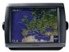
If any parts are not included. Mounting the GPSMAP 4000/5000 Series Chartplotter You can use the GPSMAP 4000/5000 chartplotter, this manual covers other installation options: • Connecting the chartplotter to other Garmin Marine Network compatible devices, such as a sounder or a radar (page 12). • Connecting the chartplotter to an existing NMEA 2000 network (page 10). • Connecting...
If any parts are not included. Mounting the GPSMAP 4000/5000 Series Chartplotter You can use the GPSMAP 4000/5000 chartplotter, this manual covers other installation options: • Connecting the chartplotter to other Garmin Marine Network compatible devices, such as a sounder or a radar (page 12). • Connecting the chartplotter to an existing NMEA 2000 network (page 10). • Connecting...
Installation Instructions
Page 10
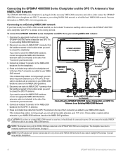
...included) T-connectors (included) 5. GPSMAP 4000/5000 series chartplotter GPS 17x antenna 3. Disconnect one side of a NMEA 2000 T-connector from the GPS 17x antenna to the top of the T-connector you added to your NMEA 2000 backbone, based on NMEA 2000, visit www.garmin.com. Do not connect the ...to the side of the T-connector you disconnected. If the included drop cable is packaged with the necessary NMEA 2000 connectors and cable to either connect the GPSMAP 4000/5000 series chartplotter and GPS 17x antenna to your NMEA 2000 backbone, based on the NMEA 2000 network. ...
...included) T-connectors (included) 5. GPSMAP 4000/5000 series chartplotter GPS 17x antenna 3. Disconnect one side of a NMEA 2000 T-connector from the GPS 17x antenna to the top of the T-connector you added to your NMEA 2000 backbone, based on NMEA 2000, visit www.garmin.com. Do not connect the ...to the side of the T-connector you disconnected. If the included drop cable is packaged with the necessary NMEA 2000 connectors and cable to either connect the GPSMAP 4000/5000 series chartplotter and GPS 17x antenna to your NMEA 2000 backbone, based on the NMEA 2000 network. ...
Installation Instructions
Page 12
...receiver (GDL30/30A). • Garmin GPSMAP 3000 series chartplotters CANNOT share cartography data with the cable. 12 GPSMAP 4000/5000 Series Installation Instructions The data is only available in the United States (lower 48). Data is shared between multiple Garmin chartplotters and other connected chartplotters. • Connect all chartplotters to the NMEA 2000 network as well as to the Garmin Marine... on the instructions packaged with the GPSMAP 4000/5000 series chartplotters. • All network components must all the connected Garmin chartplotters. Notes: •...
...receiver (GDL30/30A). • Garmin GPSMAP 3000 series chartplotters CANNOT share cartography data with the cable. 12 GPSMAP 4000/5000 Series Installation Instructions The data is only available in the United States (lower 48). Data is shared between multiple Garmin chartplotters and other connected chartplotters. • Connect all chartplotters to the NMEA 2000 network as well as to the Garmin Marine... on the instructions packaged with the GPSMAP 4000/5000 series chartplotters. • All network components must all the connected Garmin chartplotters. Notes: •...
Owner's Manual
Page 20
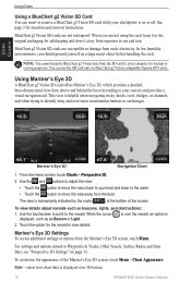
... original packaging for the navaid to your computer for insertion and removal instructions. Mariner's Eye...Mariner's Eye 3D Settings To access additional settings or options from static electricity. When you should ground yourself on BlueChart g2 Vision-compatible Garmin GPS... units. Touch the option for safekeeping and store it in unfamiliar harbors or anchorages. Style-select how chart data is displayed over the navaid, an option is over 3D terrain. 16 GPSMAP... to your chartplotter is momentarily indicated by the scale ( ) at the bottom of the Mariner's Eye 3D...
... original packaging for the navaid to your computer for insertion and removal instructions. Mariner's Eye...Mariner's Eye 3D Settings To access additional settings or options from static electricity. When you should ground yourself on BlueChart g2 Vision-compatible Garmin GPS... units. Touch the option for safekeeping and store it in unfamiliar harbors or anchorages. Style-select how chart data is displayed over the navaid, an option is over 3D terrain. 16 GPSMAP... to your chartplotter is momentarily indicated by the scale ( ) at the bottom of the Mariner's Eye 3D...
Technical Reference for Garmin NMEA 2000 Products
Page 22
...from the NMEA 2000 configuration menu on in low-speed situations and toggles off in the package. You will lose all custom configuration settings when you can force the GPS 17x to the NMEA 2000 network as potentially sporadic position information. While viewing the NMEA ... current position. 1. For convenience, this section contains the configuration information for Garmin NMEA 2000 Products On a Garmin chartplotter, select On or Off. Important: To access the NMEA 2000 configuration menu on the GPS 17x can restore factory default settings to the NMEA 2000 network. To restore...
...from the NMEA 2000 configuration menu on in low-speed situations and toggles off in the package. You will lose all custom configuration settings when you can force the GPS 17x to the NMEA 2000 network as potentially sporadic position information. While viewing the NMEA ... current position. 1. For convenience, this section contains the configuration information for Garmin NMEA 2000 Products On a Garmin chartplotter, select On or Off. Important: To access the NMEA 2000 configuration menu on the GPS 17x can restore factory default settings to the NMEA 2000 network. To restore...

