
Owner's Manual
Page 4
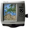
...Garmin iv Getting Started 1 Unit Overview 1 Turning the Unit On or Off 3 Initializing Unit Settings 3 Adjusting the Backlight 4 Using the Keypad 5 Acquiring GPS... Satellite Signals 5 Using Simulator Mode 6 Viewing System Information 6 Restoring the Original Factory Settings 6 Inserting and Removing SD Cards 6 Understanding the Home Screen 7 Using Charts 8 Using the Navigation Chart 8 Changing the Navigation Chart Settings 12 Using the Split Navigation Chart 14 Using Perspective 3D 15 ii Using Mariner... Vision 28 Navigating with a Garmin Autopilot 29 Viewing Information 30 ...
...Garmin iv Getting Started 1 Unit Overview 1 Turning the Unit On or Off 3 Initializing Unit Settings 3 Adjusting the Backlight 4 Using the Keypad 5 Acquiring GPS... Satellite Signals 5 Using Simulator Mode 6 Viewing System Information 6 Restoring the Original Factory Settings 6 Inserting and Removing SD Cards 6 Understanding the Home Screen 7 Using Charts 8 Using the Navigation Chart 8 Changing the Navigation Chart Settings 12 Using the Split Navigation Chart 14 Using Perspective 3D 15 ii Using Mariner... Vision 28 Navigating with a Garmin Autopilot 29 Viewing Information 30 ...
Owner's Manual
Page 13
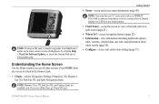
...;, update to the Home screen. • Charts-selects Navigation, Fishing, Perspective 3D, Mariner's Eye 3D, Fish Eye 3D, and Split Navigation charts. Note: You must have an "s" series unit (such as a GPSMAP 526s) with a connected transducer or have a connection to a Garmin sounder via CANet to access all other vessels (page 30). • Configure...
...;, update to the Home screen. • Charts-selects Navigation, Fishing, Perspective 3D, Mariner's Eye 3D, Fish Eye 3D, and Split Navigation charts. Note: You must have an "s" series unit (such as a GPSMAP 526s) with a connected transducer or have a connection to a Garmin sounder via CANet to access all other vessels (page 30). • Configure...

Owner's Manual
Page 14
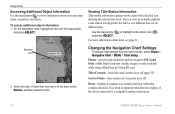
... you must insert an optional BlueChart g2 Vision preprogrammed SD card to view detailed Navigation and Mariner's Eye charts. Fishing charts and Fish Eye 3D views are using a GPSMAP 420/421/520/521/525/526 (including "s" models), you are available when using optional BlueChart g2 Vision ...well for either the USA shoreline or a specific country. • Navigation Chart-displays all relevant navigation data available on the chart. • Mariner's Eye 3D-provides a view from above and behind the boat (according to your course, to plan your course), and provides a visual navigation...
... you must insert an optional BlueChart g2 Vision preprogrammed SD card to view detailed Navigation and Mariner's Eye charts. Fishing charts and Fish Eye 3D views are using a GPSMAP 420/421/520/521/525/526 (including "s" models), you are available when using optional BlueChart g2 Vision ...well for either the USA shoreline or a specific country. • Navigation Chart-displays all relevant navigation data available on the chart. • Mariner's Eye 3D-provides a view from above and behind the boat (according to your course, to plan your course), and provides a visual navigation...
Owner's Manual
Page 18
You can view an in the area, select Review, and then select the item. Service Points-turns marine service points on or off (page 32). True wind or apparent wind direction displays if the unit is connected to help predict the tide ... home screen, select Charts > Navigation Chart > MENU > Chart Setup. High-resolution satellite imagery is in -depth graph for a tide station to a compatible marine wind sensor. 12 GPSMAP 400/500 Series Owner's Manual Selected item 2. Photos-sets the high-resolution satellite images to view information about tides, see page 32. Roses-displays...
You can view an in the area, select Review, and then select the item. Service Points-turns marine service points on or off (page 32). True wind or apparent wind direction displays if the unit is connected to help predict the tide ... home screen, select Charts > Navigation Chart > MENU > Chart Setup. High-resolution satellite imagery is in -depth graph for a tide station to a compatible marine wind sensor. 12 GPSMAP 400/500 Series Owner's Manual Selected item 2. Photos-sets the high-resolution satellite images to view information about tides, see page 32. Roses-displays...

Owner's Manual
Page 21
...Active Tracks-manage tracks (page 26). • Saved Tracks-view a list of the course line drawn when navigating. Using Mariner's Eye 3D A BlueChart g2 Vision SD card offers Mariner's Eye 3D that have been saved. Press SELECT to your boat and lower to move the view closer to your course...), and provides a visual navigation GPSMAP 400/500 Series Owner's Manual 15 To view information about navaids such as beacons, lights, and...
...Active Tracks-manage tracks (page 26). • Saved Tracks-view a list of the course line drawn when navigating. Using Mariner's Eye 3D A BlueChart g2 Vision SD card offers Mariner's Eye 3D that have been saved. Press SELECT to your boat and lower to move the view closer to your course...), and provides a visual navigation GPSMAP 400/500 Series Owner's Manual 15 To view information about navaids such as beacons, lights, and...

Owner's Manual
Page 22
... when navigating tricky shoals, reefs, bridges, or channels, and is highlighted. 2. The scale ( ) temporarily appears at the bottom of the Mariner's Eye 3D screen, select MENU > Chart Appearance. Press the Range (-) key to identify entry and exit routes in addition to view details about... navaids such as beacons, lights, and obstructions: 16 GPSMAP 400/500 Series Owner's Manual To view details about the navaid. Use the Rocker to point to the navaid. Mariner's Eye 3D Navigation Chart 1. Using Charts aid.
... when navigating tricky shoals, reefs, bridges, or channels, and is highlighted. 2. The scale ( ) temporarily appears at the bottom of the Mariner's Eye 3D screen, select MENU > Chart Appearance. Press the Range (-) key to identify entry and exit routes in addition to view details about... navaids such as beacons, lights, and obstructions: 16 GPSMAP 400/500 Series Owner's Manual To view details about the navaid. Use the Rocker to point to the navaid. Mariner's Eye 3D Navigation Chart 1. Using Charts aid.

Owner's Manual
Page 23
...unit (such as a GPSMAP 420s) and a transducer wired through a marine network to adjust the view. Blue indicates deep water, yellow is shallow water, and red is present)-turns a cone that shows the area covered by red, green, and yellow spheres. Use the Range keys to receive sonar information. Fish Eye...water. The On setting indicates shallow water and land with a color scale. Sonar Cone (only available if sonar is very shallow water. GPSMAP 400/500 Series Owner's Manual 17 Using Charts Lane Width-adjusts the width of the course line drawn when navigating. This setting also affects...
...unit (such as a GPSMAP 420s) and a transducer wired through a marine network to adjust the view. Blue indicates deep water, yellow is shallow water, and red is present)-turns a cone that shows the area covered by red, green, and yellow spheres. Use the Range keys to receive sonar information. Fish Eye...water. The On setting indicates shallow water and land with a color scale. Sonar Cone (only available if sonar is very shallow water. GPSMAP 400/500 Series Owner's Manual 17 Using Charts Lane Width-adjusts the width of the course line drawn when navigating. This setting also affects...

Owner's Manual
Page 27
...data, which includes highly detailed coastal roads and POIs such as restaurants, lodging, local attractions and more information on how to use Automatic Guidance. GPSMAP 400/500 Series Owner's Manual 21 Detailed Road and POI Data BlueChart g2 Vision contains detailed road and points of chart on page 22 has... more . See page 38 for instructions on searching for, and navigating to view the Navigation chart, Fishing chart, Mariner's Eye 3D, or Fish Eye 3D and sonar at the same time. The "Where To?" Using Charts Navigation chart screen Sonar screen Navigation/...
...data, which includes highly detailed coastal roads and POIs such as restaurants, lodging, local attractions and more information on how to use Automatic Guidance. GPSMAP 400/500 Series Owner's Manual 21 Detailed Road and POI Data BlueChart g2 Vision contains detailed road and points of chart on page 22 has... more . See page 38 for instructions on searching for, and navigating to view the Navigation chart, Fishing chart, Mariner's Eye 3D, or Fish Eye 3D and sonar at the same time. The "Where To?" Using Charts Navigation chart screen Sonar screen Navigation/...

Owner's Manual
Page 34
...is determined by distance, time, or resolution. (Select Change to get the most -efficient use of current-station information (page 32). 28 GPSMAP 400/500 Series Owner's Manual Track Color-sets the color of the chart with new data. Using BlueChart g2 Vision Optional BlueChart g2 Vision ...preprogrammed SD cards allow you visualize your course. The BlueChart g2 Vision Mariner's Eye 3D is recorded. Recording more-frequent plots is more detailed than the preloaded data (page 15). • Fish Eye 3D-provides ...
...is determined by distance, time, or resolution. (Select Change to get the most -efficient use of current-station information (page 32). 28 GPSMAP 400/500 Series Owner's Manual Track Color-sets the color of the chart with new data. Using BlueChart g2 Vision Optional BlueChart g2 Vision ...preprogrammed SD cards allow you visualize your course. The BlueChart g2 Vision Mariner's Eye 3D is recorded. Recording more-frequent plots is more detailed than the preloaded data (page 15). • Fish Eye 3D-provides ...
Owner's Manual
Page 68
...battery 42 clock 42 collision 44 deep water 42 fish 42 fuel 42 GPS accuracy 42 navigation 41 safe-zone 44 shallow water 42 sonar 42 water ... using 21 chart data 10 charts detail 13 fish eye 3D 17 fishing 18 mariner's eye 3D 15 navigation 8 settings 12 Clear User Data 33 collision alarm 44... 17 Color Scheme 48 Communications 40 Compass 30 compass rose 12 contact information, Garmin iv course up 13 current stations 32 customizing chart settings 12 D Dashboard 30... 31 full screen, sonar 45 fuse 56 G gain 49 Garmin Data Transfer 40 gauges fuel 31 go to 22 GPS 5, 37, 56 Grid (North) 38 guide to 22 ...
...battery 42 clock 42 collision 44 deep water 42 fish 42 fuel 42 GPS accuracy 42 navigation 41 safe-zone 44 shallow water 42 sonar 42 water ... using 21 chart data 10 charts detail 13 fish eye 3D 17 fishing 18 mariner's eye 3D 15 navigation 8 settings 12 Clear User Data 33 collision alarm 44... 17 Color Scheme 48 Communications 40 Compass 30 compass rose 12 contact information, Garmin iv course up 13 current stations 32 customizing chart settings 12 D Dashboard 30... 31 full screen, sonar 45 fuse 56 G gain 49 Garmin Data Transfer 40 gauges fuel 31 go to 22 GPS 5, 37, 56 Grid (North) 38 guide to 22 ...
Owner's Manual
Page 69
... 60 scroll speed 47 SD cards inserting 6 removing 6 L Lane Width 15, 17 Language 38 M Man Overboard 24, 52 map datum 38 MapSource data 33 mariner's eye 3D colors 17 mark current location 24 MENU key 5 messages 57 move a waypoint 24 My Boat 43 N Navaid Type 14 Navigate To 11, 23... 15 photos 12 physical specifications 55 Points of measure 37 Shoreline Distance 39 simulator 37 mode 6 Skyview 37 software license agreement 61 software version 37 GPSMAP 400/500 Series Owner's Manual 63 Precision 40 R radio 50 Range (sonar) 49 Range keys 5 Range Rings 15, 17 registering your product iv restoring ...
... 60 scroll speed 47 SD cards inserting 6 removing 6 L Lane Width 15, 17 Language 38 M Man Overboard 24, 52 map datum 38 MapSource data 33 mariner's eye 3D colors 17 mark current location 24 MENU key 5 messages 57 move a waypoint 24 My Boat 43 N Navaid Type 14 Navigate To 11, 23... 15 photos 12 physical specifications 55 Points of measure 37 Shoreline Distance 39 simulator 37 mode 6 Skyview 37 software license agreement 61 software version 37 GPSMAP 400/500 Series Owner's Manual 63 Precision 40 R radio 50 Range (sonar) 49 Range keys 5 Range Rings 15, 17 registering your product iv restoring ...


