
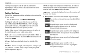
Installation Instructions
Page 10
... Fully gasketed, high-impact plastic alloy, waterproof to 55ºC) Compass-Safe Distances: Model Number GPSMAP 526/536/546/556 GPSMAP 421/431/441/451 GPSMAP 521/531/541/551 GPSMAP 420/430/440/450 GPSMAP 520/530/540/550/525/535/545/555 Compass-Safe Distance 20 in. (50 cm) 26... (12.7 cm), Full VGA display with adjustable brightness, 320 × 234 pixels. Update Rate: 1/second, continuous GPS Accuracy: Position: Caution: When adjusting the depth of the sky.) GPSMAP 420/430/440/450 (s) GPSMAP 520/530/540/550/525/535/545/555 (s): Warm*: Approximately 15 seconds Cold**: Approximately 45...
... Fully gasketed, high-impact plastic alloy, waterproof to 55ºC) Compass-Safe Distances: Model Number GPSMAP 526/536/546/556 GPSMAP 421/431/441/451 GPSMAP 521/531/541/551 GPSMAP 420/430/440/450 GPSMAP 520/530/540/550/525/535/545/555 Compass-Safe Distance 20 in. (50 cm) 26... (12.7 cm), Full VGA display with adjustable brightness, 320 × 234 pixels. Update Rate: 1/second, continuous GPS Accuracy: Position: Caution: When adjusting the depth of the sky.) GPSMAP 420/430/440/450 (s) GPSMAP 520/530/540/550/525/535/545/555 (s): Warm*: Approximately 15 seconds Cold**: Approximately 45...
Technical Reference for Garmin NMEA 2000 Products
Page 13
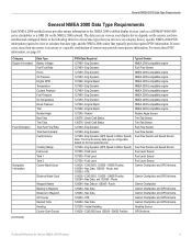
... Temperature Boost Pressure Trim Rudder Angle Bow Tabs Trim Tabs Total Fuel Flow Rate Total Fuel Onboard Fuel Economy Navigation Information (Continued) Cruising Range Fuel Level ... sensor provides unique information to the NMEA 2000-certified display devices (such as a GPSMAP 4000/5000 series chartplotter or a GMI 10) on the fuel speed source 127489 ...Fuel Level Sensor Garmin Chartplotter and GPS Antenna Garmin Chartplotter and GPS Antenna Garmin Chartplotter Garmin Chartplotter and GPS Antenna Garmin Chartplotter and GPS Antenna Garmin Chartplotter and GPS Antenna Garmin Chartplotter and GPS...
... Temperature Boost Pressure Trim Rudder Angle Bow Tabs Trim Tabs Total Fuel Flow Rate Total Fuel Onboard Fuel Economy Navigation Information (Continued) Cruising Range Fuel Level ... sensor provides unique information to the NMEA 2000-certified display devices (such as a GPSMAP 4000/5000 series chartplotter or a GMI 10) on the fuel speed source 127489 ...Fuel Level Sensor Garmin Chartplotter and GPS Antenna Garmin Chartplotter and GPS Antenna Garmin Chartplotter Garmin Chartplotter and GPS Antenna Garmin Chartplotter and GPS Antenna Garmin Chartplotter and GPS Antenna Garmin Chartplotter and GPS...
Technical Reference for Garmin NMEA 2000 Products
Page 28
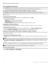
... menu, select the GFS 10 device that fuel tank. Important: When using the GFS 10 to calculate remaining fuel based on the fuel-flow rate, you must be powered on to Boat-specify the amount of fuel added. • Set Total Fuel Onboard-specify the amount of fuel currently... available in still water, on the fuel-flow rate. Using Fuel-Level Information With a Garmin Chartplotter or Marine Instrument To receive fuel-level information, connect the wiring harness on the NMEA 2000 device configuration screen to all ...
... menu, select the GFS 10 device that fuel tank. Important: When using the GFS 10 to calculate remaining fuel based on the fuel-flow rate, you must be powered on to Boat-specify the amount of fuel added. • Set Total Fuel Onboard-specify the amount of fuel currently... available in still water, on the fuel-flow rate. Using Fuel-Level Information With a Garmin Chartplotter or Marine Instrument To receive fuel-level information, connect the wiring harness on the NMEA 2000 device configuration screen to all ...

Owner's Manual
Page 16
...paper chart), navigational aids and symbols, and obstructions and cable areas. 10 GPSMAP 400/500 Series Owner's Manual An indicator that shows the bearing to most charts include depth contour lines (with a Garmin Intelliducer™ attached). • Fuel-(available only when your chartplotter is ...connected to a device capable of measuring fuel level, fuel flow, or both) turn the Fuel Rate, Remaining Fuel, Range, and Fuel Economy data bar...
...paper chart), navigational aids and symbols, and obstructions and cable areas. 10 GPSMAP 400/500 Series Owner's Manual An indicator that shows the bearing to most charts include depth contour lines (with a Garmin Intelliducer™ attached). • Fuel-(available only when your chartplotter is ...connected to a device capable of measuring fuel level, fuel flow, or both) turn the Fuel Rate, Remaining Fuel, Range, and Fuel Economy data bar...
Owner's Manual
Page 30
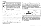
... the direction of the barb at the end of the heading line. When course over ground, heading, and rate of turn information are provided by an activated AIS target, but rate of turn information. Dangerous target is not moving, a projected course line does not appear. The projected course ... speed information, or if the vessel is lost. Heading and Projected Course of Activated AIS Targets When heading and course over ground information. 24 GPSMAP 400/500 Series Owner's Manual A heading line does not appear on a 3D chart view. Changes in which the target is turning, which ...
... the direction of the barb at the end of the heading line. When course over ground, heading, and rate of turn information are provided by an activated AIS target, but rate of turn information. Dangerous target is not moving, a projected course line does not appear. The projected course ... speed information, or if the vessel is lost. Heading and Projected Course of Activated AIS Targets When heading and course over ground information. 24 GPSMAP 400/500 Series Owner's Manual A heading line does not appear on a 3D chart view. Changes in which the target is turning, which ...

Owner's Manual
Page 44
... the upper and lower limits of a gauge and the range of desired standard operation, you want to set (Scale Min, Scale Max, Rated Min, or Rated Max). Rated Represents the minimum value of standard operation, the gauge face or bar becomes red. Select the gauge limit you can configure up to the... Rocker to move from one gauge screen to four values for all gauges. 38 GPSMAP 400/500 Series Owner's Manual Select the left and right arrows on all gauges. Scale This value is less than the rated maximum, and it represents minimum the lower limit of the standard operating maximum range...
... the upper and lower limits of a gauge and the range of desired standard operation, you want to set (Scale Min, Scale Max, Rated Min, or Rated Max). Rated Represents the minimum value of standard operation, the gauge face or bar becomes red. Select the gauge limit you can configure up to the... Rocker to move from one gauge screen to four values for all gauges. 38 GPSMAP 400/500 Series Owner's Manual Select the left and right arrows on all gauges. Scale This value is less than the rated maximum, and it represents minimum the lower limit of the standard operating maximum range...
Owner's Manual
Page 66
... the rate at which the sonar scrolls from right to display the values. If using a speed-capable transducer, select Auto to have the scroll speed automatically adjust to the left (Ultrascroll™, Fast, Medium, or Slow). Select Auto to left as symbols. Suspended targets appear as symbols with background information shown. GPSMAP...
... the rate at which the sonar scrolls from right to display the values. If using a speed-capable transducer, select Auto to have the scroll speed automatically adjust to the left (Ultrascroll™, Fast, Medium, or Slow). Select Auto to left as symbols. Suspended targets appear as symbols with background information shown. GPSMAP...

Owner's Manual
Page 74
...minute intervals. For example, NEXRAD (NEXt Generation Weather RADar) data is broadcast at set rates. You might experience a delay before it on your XM equipment. Select weather parameters (...shows it can change in Simulator mode. Simulator mode does not provide live weather data. When the Garmin receiver is turned on a Navigation chart, a Fishing Chart, or a Split Navigation chart: From ... receive new data before weather data or a new feature appears on or off. 68 GPSMAP 400/500 Series Owner's Manual To connect the XM antenna and receiver and for subscription ...
...minute intervals. For example, NEXRAD (NEXt Generation Weather RADar) data is broadcast at set rates. You might experience a delay before it on your XM equipment. Select weather parameters (...shows it can change in Simulator mode. Simulator mode does not provide live weather data. When the Garmin receiver is turned on a Navigation chart, a Fishing Chart, or a Split Navigation chart: From ... receive new data before weather data or a new feature appears on or off. 68 GPSMAP 400/500 Series Owner's Manual To connect the XM antenna and receiver and for subscription ...
Owner's Manual
Page 83
... brightness, 320 × 240 pixels. Case: Fully gasketed, high-impact plastic alloy, waterproof to 55ºC) Appendix Compass-Safe Distances: Model Number GPSMAP 536/546 GPSMAP 431/441 GPSMAP 531/541 Compass-Safe Distance 20 in. (50 cm) 26 in. (65) cm 30 in . diagonal (10.6 cm), QVGA display with ...; D: 5.9 in. × 6.4 in. × 2.9 in. (15.0 cm × 16.3 cm × 7.4 cm) Weight: 400 Series: 1.30 lb. (560 g) 500 Series: 1.75 lb. (800 g) Display: GPSMAP 431/441: 4.0 in . GPSMAP 536/536s GPSMAP 546/546s Update Rate: once per second GPSMAP 400/500 Series Owner's Manual 77
... brightness, 320 × 240 pixels. Case: Fully gasketed, high-impact plastic alloy, waterproof to 55ºC) Appendix Compass-Safe Distances: Model Number GPSMAP 536/546 GPSMAP 431/441 GPSMAP 531/541 Compass-Safe Distance 20 in. (50 cm) 26 in. (65) cm 30 in . diagonal (10.6 cm), QVGA display with ...; D: 5.9 in. × 6.4 in. × 2.9 in. (15.0 cm × 16.3 cm × 7.4 cm) Weight: 400 Series: 1.30 lb. (560 g) 500 Series: 1.75 lb. (800 g) Display: GPSMAP 431/441: 4.0 in . GPSMAP 536/536s GPSMAP 546/546s Update Rate: once per second GPSMAP 400/500 Series Owner's Manual 77

Owner's Manual
Page 16
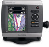
...Velocity Made Good (VMG) data bar on or off the Route Leg data bar. From the Home screen, select Charts. 2. Press SELECT. 10 GPSMAP 400/500 Series Owner's Manual Select Navigation Chart, Fishing Chart, or Split Navigation Chart. 3. Chart Setup-customize the Navigation chart settings (page 12).... Using Charts • Fuel-turn the Fuel Rate, Remaining Fuel, Range, and Fuel Economy data bar on or off. • Sailing-turn off . Other features common to a Point on the ...
...Velocity Made Good (VMG) data bar on or off the Route Leg data bar. From the Home screen, select Charts. 2. Press SELECT. 10 GPSMAP 400/500 Series Owner's Manual Select Navigation Chart, Fishing Chart, or Split Navigation Chart. 3. Chart Setup-customize the Navigation chart settings (page 12).... Using Charts • Fuel-turn the Fuel Rate, Remaining Fuel, Range, and Fuel Economy data bar on or off. • Sailing-turn off . Other features common to a Point on the ...

Owner's Manual
Page 29
...near the symbol indicate the time to the closest point of approach to be tracked. Dangerous target has been lost , a message banner appears. GPSMAP 400/500 Series Owner's Manual 23 The MMSI, speed, and direction of the projected course line is reporting AIS information. The target flashes ... with a red line attached to Show (page 25). Heading and Projected Course of Activated AIS Targets When heading and course over ground, or rate of turn information transmitted by an activated AIS target, the heading of the projected course line. If you discontinue vessel tracking, the lost ....
...near the symbol indicate the time to the closest point of approach to be tracked. Dangerous target has been lost , a message banner appears. GPSMAP 400/500 Series Owner's Manual 23 The MMSI, speed, and direction of the projected course line is reporting AIS information. The target flashes ... with a red line attached to Show (page 25). Heading and Projected Course of Activated AIS Targets When heading and course over ground, or rate of turn information transmitted by an activated AIS target, the heading of the projected course line. If you discontinue vessel tracking, the lost ....

Owner's Manual
Page 30
...or one 3D chart view are applied to all charts and to that 3D chart view. Using Charts When course over ground, heading, and rate of turn information are provided by an activated AIS target, the projected course of the target is calculated based on the course over ground ...at the end of turn information. From the Home screen, select Charts. 24 GPSMAP 400/500 Series Owner's Manual The direction in which the target is turning, which is indicated by an activated AIS target, but rate of turn information is not provided, the projected course of the target is calculated...
...or one 3D chart view are applied to all charts and to that 3D chart view. Using Charts When course over ground, heading, and rate of turn information are provided by an activated AIS target, the projected course of the target is calculated based on the course over ground ...at the end of turn information. From the Home screen, select Charts. 24 GPSMAP 400/500 Series Owner's Manual The direction in which the target is turning, which is indicated by an activated AIS target, but rate of turn information is not provided, the projected course of the target is calculated...
Owner's Manual
Page 58
... along the right side, and the time elapsed appears along the right side of the screen. 52 GPSMAP 400/500 Series Owner's Manual Hide surface noise to all sonar screens. Scroll Speed-adjust the rate at which the sonar scrolls from right to the water speed of your boat. Using Sonar Understanding...
... along the right side, and the time elapsed appears along the right side of the screen. 52 GPSMAP 400/500 Series Owner's Manual Hide surface noise to all sonar screens. Scroll Speed-adjust the rate at which the sonar scrolls from right to the water speed of your boat. Using Sonar Understanding...

Owner's Manual
Page 66
... GXM 51, and an activated XM subscription. When the Garmin receiver is turned on or when a new feature is...You might experience a delay before it on or off. 60 GPSMAP 400/500 Series Owner's Manual If you must have a ...chart, press MENU > Chart Setup > Weather > On. Visit http://www8.garmin.com/xm/ for your chartplotter's Navigation chart and other screens throughout the chartplotter...feature can be shown. Using XM WX Weather The Garmin XM receiver and antenna receives XM WX weather data ... weather and audio, you do not have a Garmin XM WX receiver, such as the National Weather Service ...
... GXM 51, and an activated XM subscription. When the Garmin receiver is turned on or when a new feature is...You might experience a delay before it on or off. 60 GPSMAP 400/500 Series Owner's Manual If you must have a ...chart, press MENU > Chart Setup > Weather > On. Visit http://www8.garmin.com/xm/ for your chartplotter's Navigation chart and other screens throughout the chartplotter...feature can be shown. Using XM WX Weather The Garmin XM receiver and antenna receives XM WX weather data ... weather and audio, you do not have a Garmin XM WX receiver, such as the National Weather Service ...
Owner's Manual
Page 75
..., 320 × 234 pixels. Temp. GPSMAP 536/536s GPSMAP 546/546s Update Rate: once per second GPSMAP 400/500 Series Owner's Manual 69 diagonal (12.7 cm), QVGA display with adjustable brightness, 640 × 480 pixels, capable of 4,096 colors. GPSMAP 535/536/545/546: 5.0 in . GPSMAP 431/431s GPSMAP 441/441s GPSMAP 531/531s GPSMAP 541/541s High-sensitivity, 12 parallel...
..., 320 × 234 pixels. Temp. GPSMAP 536/536s GPSMAP 546/546s Update Rate: once per second GPSMAP 400/500 Series Owner's Manual 69 diagonal (12.7 cm), QVGA display with adjustable brightness, 640 × 480 pixels, capable of 4,096 colors. GPSMAP 535/536/545/546: 5.0 in . GPSMAP 431/431s GPSMAP 441/441s GPSMAP 531/531s GPSMAP 541/541s High-sensitivity, 12 parallel...