Important Safety and Product Information
Page 3
...Repairs should only be determined by one year from the date of the purchase price at its sole discretion. Garmin retains the exclusive right to repair or replace the unit or software or offer a full refund of purchase. This product is warranted to be used only as to the accuracy ...or completeness of direction, distance, location, or topography. Limited Warranty This Garmin product is intended to be free from the GPS ...
...Repairs should only be determined by one year from the date of the purchase price at its sole discretion. Garmin retains the exclusive right to repair or replace the unit or software or offer a full refund of purchase. This product is warranted to be used only as to the accuracy ...or completeness of direction, distance, location, or topography. Limited Warranty This Garmin product is intended to be free from the GPS ...

Remote Instructions (Multilingual)
Page 1
...Information in a residential installation, and are more stringent than "outdoor" requirements. Visit the Garmin Web site (www.garmin.com) for Class B digital devices FOR HOME OR OFFICE USE. GPSMAP® is subject to radio communications if not installed and used without obligation to the ..., warnings, cautions, and the software license agreement. or its subsidiaries. Garmin hereby grants permission to change without the express prior written consent of Garmin. Garmin reserves the right to download a single copy of this and other countries. Garmin® is no part of ...
...Information in a residential installation, and are more stringent than "outdoor" requirements. Visit the Garmin Web site (www.garmin.com) for Class B digital devices FOR HOME OR OFFICE USE. GPSMAP® is subject to radio communications if not installed and used without obligation to the ..., warnings, cautions, and the software license agreement. or its subsidiaries. Garmin hereby grants permission to change without the express prior written consent of Garmin. Garmin reserves the right to download a single copy of this and other countries. Garmin® is no part of ...
Remote Instructions (Multilingual)
Page 2
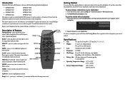
...your chartplotter has the current software, available at any time to return to unlock. MOB (Man Overboard)-press to mark your remote with the following Garmin chartplotters: • GPSMAP 4008 GPSMAP 5008 • GPSMAP 4012 GPSMAP 5012 • GPSMAP 4208 GPSMAP 5208 • GPSMAP 4212 GPSMAP 5212 The remote is ...on two AAA batteries (not included). Press again to the Home screen. HOME MOB (Man OverBoard) HOME-press at www.garmin.com. Use alkaline batteries for use a small Phillips screwdriver to 185°F) Set Allow New Connections to mark your current...
...your chartplotter has the current software, available at any time to return to unlock. MOB (Man Overboard)-press to mark your remote with the following Garmin chartplotters: • GPSMAP 4008 GPSMAP 5008 • GPSMAP 4012 GPSMAP 5012 • GPSMAP 4208 GPSMAP 5208 • GPSMAP 4212 GPSMAP 5212 The remote is ...on two AAA batteries (not included). Press again to the Home screen. HOME MOB (Man OverBoard) HOME-press at www.garmin.com. Use alkaline batteries for use a small Phillips screwdriver to 185°F) Set Allow New Connections to mark your current...
Owner's Manual
Page 4
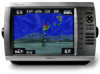
... 22 Where To 23 Navigating to a Destination 23 Creating and Using Waypoints 25 Creating and Using Routes 27 Navigating with a Garmin Autopilot 28 Viewing Information 29 Viewing Tide Station Information 29 Viewing Current Information 29 Viewing Celestial Information 30 Viewing User Data 30 ... 66 NMEA 0183 and NMEA 2000 67 Capturing Screenshots 68 Messages and Alarms 69 Product Registration 73 Contact Garmin 73 Declaration of Conformity 73 Weather Data Warranty 73 Software License Agreement 74 XM Satellite Radio Service Agreement 74 Index 75 GPSMAP 4000 Series Owner's Manual
... 22 Where To 23 Navigating to a Destination 23 Creating and Using Waypoints 25 Creating and Using Routes 27 Navigating with a Garmin Autopilot 28 Viewing Information 29 Viewing Tide Station Information 29 Viewing Current Information 29 Viewing Celestial Information 30 Viewing User Data 30 ... 66 NMEA 0183 and NMEA 2000 67 Capturing Screenshots 68 Messages and Alarms 69 Product Registration 73 Contact Garmin 73 Declaration of Conformity 73 Weather Data Warranty 73 Software License Agreement 74 XM Satellite Radio Service Agreement 74 Index 75 GPSMAP 4000 Series Owner's Manual
Owner's Manual
Page 8
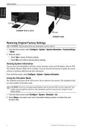
... practice. Getting Started Getting Started Card label GPSMAP 4210 or 4212 Card label GPSMAP 4208 Restoring Original Factory Settings Caution: This procedure deletes any information you have entered. 1. Select an option: • Select Yes to restore all factory settings. • Select No to update the system software or purchase additional map data information. Using...
... practice. Getting Started Getting Started Card label GPSMAP 4210 or 4212 Card label GPSMAP 4208 Restoring Original Factory Settings Caution: This procedure deletes any information you have entered. 1. Select an option: • Select Yes to restore all factory settings. • Select No to update the system software or purchase additional map data information. Using...
Owner's Manual
Page 34
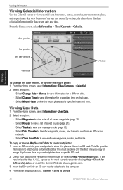
... Sky view window Overhead Horizon Viewing Information To change the date or time, or to Device. 30 GPSMAP 4000 Series Owner's Manual From the Home screen, select Information > User Data. 2. Select an option...This must be done only the first time you copy or merge MapSource data to view the moon phase at www.garmin.com. 3. Check your chartplotter to allow it to place a file on that date. • Select Moon Phase... About MapSource. By default, the chartplotter displays celestial information for Software Updates, or check the Garmin Web site at the specified date and time.
... Sky view window Overhead Horizon Viewing Information To change the date or time, or to Device. 30 GPSMAP 4000 Series Owner's Manual From the Home screen, select Information > User Data. 2. Select an option...This must be done only the first time you copy or merge MapSource data to view the moon phase at www.garmin.com. 3. Check your chartplotter to allow it to place a file on that date. • Select Moon Phase... About MapSource. By default, the chartplotter displays celestial information for Software Updates, or check the Garmin Web site at the specified date and time.

Owner's Manual
Page 41
...to communicate with the chartplotter. If a NMEA 2000 device has configuration options or settings, select the device for a list of Garmin-proprietary data for most AIS receivers. supports the input or output of standard 0183 data for interfacing with each port to use ...-Assign a preferred device when more than one chartplotter on the network to negotiate with Garmin software. • Output Sentences-configure how the device sees NMEA 0183 output sentences. Configuring the Device GPSMAP 4000 Series Owner's Manual 37 Precision-adjust the number of digits (Two Digits, Three...
...to communicate with the chartplotter. If a NMEA 2000 device has configuration options or settings, select the device for a list of Garmin-proprietary data for most AIS receivers. supports the input or output of standard 0183 data for interfacing with each port to use ...-Assign a preferred device when more than one chartplotter on the network to negotiate with Garmin software. • Output Sentences-configure how the device sees NMEA 0183 output sentences. Configuring the Device GPSMAP 4000 Series Owner's Manual 37 Precision-adjust the number of digits (Two Digits, Three...
Owner's Manual
Page 73
.... Contact product support. Directory Item With This MMSI Already Exists-MMSI number is needed. Contact product support for assistance updating your chartplotter software. travel to the GPS 17 antenna. Appendix Messages and Alarms AIS: Dangerous Target-an AIS target currently presents a collision threat. Anchor... Arrival Alarm -arriving at destination waypoint. Can't Write User Card-cannot write card when attempting a user data transfer. Software Update Required-a software update is already in the wiring to water within the specified safe depth. Check connectivity...
.... Contact product support. Directory Item With This MMSI Already Exists-MMSI number is needed. Contact product support for assistance updating your chartplotter software. travel to the GPS 17 antenna. Appendix Messages and Alarms AIS: Dangerous Target-an AIS target currently presents a collision threat. Anchor... Arrival Alarm -arriving at destination waypoint. Can't Write User Card-cannot write card when attempting a user data transfer. Software Update Required-a software update is already in the wiring to water within the specified safe depth. Check connectivity...
Owner's Manual
Page 74
...-a position report has been received by the DSC module. Contact product support for assistance updating your chartplotter software. Make sure you have a clear view of the sky. GPS Service Lost-the chartplotter has lost ...software update is a weather warning in effect. Enter a number between (0 - 252)-invalid NMEA 2000 Device instance. Lost Satellite Reception-the chartplotter has lost connection to the remote GPS. Lost Remote GPS Connection-lost satellite reception. MARPA: Dangerous Target-(radar) a MARPA target has become dangerous. 70 GPSMAP...
...-a position report has been received by the DSC module. Contact product support for assistance updating your chartplotter software. Make sure you have a clear view of the sky. GPS Service Lost-the chartplotter has lost ...software update is a weather warning in effect. Enter a number between (0 - 252)-invalid NMEA 2000 Device instance. Lost Satellite Reception-the chartplotter has lost connection to the remote GPS. Lost Remote GPS Connection-lost satellite reception. MARPA: Dangerous Target-(radar) a MARPA target has become dangerous. 70 GPSMAP...
Owner's Manual
Page 75
... memory is full. Radar Service Incompatible. Erase existing routes to track a marpa target any longer. Software Update Required-a radar software update is a severe storm warning in the user-defined radar guard zone. Choose another proximity waypoint. GPSMAP 4000 Series Owner's Manual 71 Proximity Overlaps Another Proximity Waypoint-a proximity point is full, no more...
... memory is full. Radar Service Incompatible. Erase existing routes to track a marpa target any longer. Software Update Required-a radar software update is a severe storm warning in the user-defined radar guard zone. Choose another proximity waypoint. GPSMAP 4000 Series Owner's Manual 71 Proximity Overlaps Another Proximity Waypoint-a proximity point is full, no more...
Owner's Manual
Page 76
... end of the track have a strong XM signal. Transducer Disconnected, Sonar Turned Off-the transducer has been disconnected. Software Update Required-an XM WX weather software update is no longer communicating. Contact product support for obstructions and check wiring. XM Service Incompatible. Sonar Failed, Unit...) the weather service is full. Check the network and the XM wiring. Contact product support for assistance updating your network. 72 GPSMAP 4000 Series Owner's Manual Check the network and the sonar wiring. Track Memory is Full, Can't Create Track-the saved track ...
... end of the track have a strong XM signal. Transducer Disconnected, Sonar Turned Off-the transducer has been disconnected. Software Update Required-an XM WX weather software update is no longer communicating. Contact product support for obstructions and check wiring. XM Service Incompatible. Sonar Failed, Unit...) the weather service is full. Check the network and the XM wiring. Contact product support for assistance updating your network. 72 GPSMAP 4000 Series Owner's Manual Check the network and the sonar wiring. Track Memory is Full, Can't Create Track-the saved track ...
Owner's Manual
Page 77
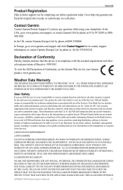
... with any aircraft, sea craft or automobile usage. Weather Data Warranty THE WEATHER DATA SOFTWARE PRODUCT IS PROVIDED "AS IS." XM and Garmin assume no event will XM and Garmin, their data suppliers, service providers, marketing/distribution, software or Internet partners or hardware manufacturers be relied upon as is not for "safety for... THAT GAVE RISE TO THE APPLICABLE DAMAGE OR LOSS. Keep the original sales receipt, or a photocopy, in a safe place. THIS ALLOCATION OF RISK IS GPSMAP 4000 Series Owner's Manual 73 by phone at 0808 2380000. This information is your...
... with any aircraft, sea craft or automobile usage. Weather Data Warranty THE WEATHER DATA SOFTWARE PRODUCT IS PROVIDED "AS IS." XM and Garmin assume no event will XM and Garmin, their data suppliers, service providers, marketing/distribution, software or Internet partners or hardware manufacturers be relied upon as is not for "safety for... THAT GAVE RISE TO THE APPLICABLE DAMAGE OR LOSS. Keep the original sales receipt, or a photocopy, in a safe place. THIS ALLOCATION OF RISK IS GPSMAP 4000 Series Owner's Manual 73 by phone at 0808 2380000. This information is your...
Owner's Manual
Page 78
...DESCRIBED ABOVE UNDER YOUR STATE'S LAWS. You further acknowledge that the structure, organization, and code of the Software are valuable trade secrets of Garmin and that the Software is the property of Defense (10 U.S.C. 425). Other fees and taxes, including a one-time activation ...of XM Satellite Radio Inc. 74 GPSMAP 4000 Series Owner's Manual Subscription fee is protected under the United States of a navigational aid prepared or disseminated by hardware equipment. b. Available only in Garmin. You acknowledge that the Software in law or from or connected with...
...DESCRIBED ABOVE UNDER YOUR STATE'S LAWS. You further acknowledge that the structure, organization, and code of the Software are valuable trade secrets of Garmin and that the Software is the property of Defense (10 U.S.C. 425). Other fees and taxes, including a one-time activation ...of XM Satellite Radio Inc. 74 GPSMAP 4000 Series Owner's Manual Subscription fee is protected under the United States of a navigational aid prepared or disseminated by hardware equipment. b. Available only in Garmin. You acknowledge that the Software in law or from or connected with...
Owner's Manual
Page 80
... eye 3D 17 initializing 2 mariner's eye 3D 16 navigation chart 7 sonar 52 sonar (advanced) 52 76 system 35 XM audio 65 simulator mode 4 soft key i software license agreement 74 sonar 5, 50 A-scope 52 advanced settings 52 depth line 52 full screen 50 gain 53 range 52, 53 scroll speed 52 split... move existing 26 waypoints & tracks 7 weather 5 fronts 61 where to? 5, 23 whiteline 52 wireless devices 37 X XM 58 audio 41, 65 weather 58 Z zoom 6, 53 GPSMAP 4000 Series Owner's Manual
... eye 3D 17 initializing 2 mariner's eye 3D 16 navigation chart 7 sonar 52 sonar (advanced) 52 76 system 35 XM audio 65 simulator mode 4 soft key i software license agreement 74 sonar 5, 50 A-scope 52 advanced settings 52 depth line 52 full screen 50 gain 53 range 52, 53 scroll speed 52 split... move existing 26 waypoints & tracks 7 weather 5 fronts 61 where to? 5, 23 whiteline 52 wireless devices 37 X XM 58 audio 41, 65 weather 58 Z zoom 6, 53 GPSMAP 4000 Series Owner's Manual

Owner's Manual
Page 84
or its subsidiaries Garmin International, Inc. 1200 East 151st Street, Olathe, Kansas 66062, USA Garmin (Europe) Ltd. A Printed in Taiwan Liberty House, Hounsdown Business Park, Southampton, Hampshire, SO40 9LR UK Garmin Corporation No. 68, Jangshu 2nd Road, Shijr, Taipei County, Taiwan www.garmin.com April 2009 Part Number 190-01078-00 Rev. For the latest free software updates (excluding map data) throughout the life of your Garmin products, visit the Garmin Web site at www.garmin.com. © 2009 Garmin Ltd.
or its subsidiaries Garmin International, Inc. 1200 East 151st Street, Olathe, Kansas 66062, USA Garmin (Europe) Ltd. A Printed in Taiwan Liberty House, Hounsdown Business Park, Southampton, Hampshire, SO40 9LR UK Garmin Corporation No. 68, Jangshu 2nd Road, Shijr, Taipei County, Taiwan www.garmin.com April 2009 Part Number 190-01078-00 Rev. For the latest free software updates (excluding map data) throughout the life of your Garmin products, visit the Garmin Web site at www.garmin.com. © 2009 Garmin Ltd.

Technical Reference for Garmin NMEA 2000 Products
Page 30
... Garmin chartplotter or marine instrument changes with the engine RPM, the adapter may not be detecting the wrong type of gauge. Configuring the GRA 10 Adapter if the Rudder Angle Calibration and Gauge Type Selections Are Not Displayed Depending on the version of software ... put the engine in degrees. 5. When the boat is complete. Select an option: • For most Garmin chartplotters, select Review > Rudder Angle Calibration. • For other Garmin marine devices, select Config > Rudder Angle Calibration. 4. To access the NMEA 2000 configuration menu on -screen instructions...
... Garmin chartplotter or marine instrument changes with the engine RPM, the adapter may not be detecting the wrong type of gauge. Configuring the GRA 10 Adapter if the Rudder Angle Calibration and Gauge Type Selections Are Not Displayed Depending on the version of software ... put the engine in degrees. 5. When the boat is complete. Select an option: • For most Garmin chartplotters, select Review > Rudder Angle Calibration. • For other Garmin marine devices, select Config > Rudder Angle Calibration. 4. To access the NMEA 2000 configuration menu on -screen instructions...

Technical Reference for Garmin NMEA 2000 Products
Page 32
... GET 10 Adapter if the Engine Tilt Calibration, Engine Number, and Gauge Type Selections Are Not Displayed Depending on the version of software loaded on your boat has multiple engines, you must calibrate the tilt of the engine that the adapter is at 100%. 5. ...use the GET 10 adapter, you can indicate which engine each GET 10 adapter is not displayed: If your Garmin marine instrument, the specific configuration options may be displayed on a connected Garmin chartplotter or marine instrument changes with . 1. Enter the following command: "ENGINETILT=100Done" 6. Select an option:...
... GET 10 Adapter if the Engine Tilt Calibration, Engine Number, and Gauge Type Selections Are Not Displayed Depending on the version of software loaded on your boat has multiple engines, you must calibrate the tilt of the engine that the adapter is at 100%. 5. ...use the GET 10 adapter, you can indicate which engine each GET 10 adapter is not displayed: If your Garmin marine instrument, the specific configuration options may be displayed on a connected Garmin chartplotter or marine instrument changes with . 1. Enter the following command: "ENGINETILT=100Done" 6. Select an option:...

Technical Reference for Garmin NMEA 2000 Products
Page 35
... Number and Fluid Type Selections Are Not Displayed Depending on the version of software loaded on the configuration screens. Select an option: • For most Garmin chartplotters, select Review > Gauge Type. • For other Garmin marine devices, select Config >Generic Configuration. 3. For example, INSTANCE=2Done ...10 device. 2. To change the gauge type. To configure the tank number if the menu option is not displayed: If your Garmin marine instrument, the specific configuration options may not be displayed on your boat has multiple fluid tanks, you can indicate the type ...
... Number and Fluid Type Selections Are Not Displayed Depending on the version of software loaded on the configuration screens. Select an option: • For most Garmin chartplotters, select Review > Gauge Type. • For other Garmin marine devices, select Config >Generic Configuration. 3. For example, INSTANCE=2Done ...10 device. 2. To change the gauge type. To configure the tank number if the menu option is not displayed: If your Garmin marine instrument, the specific configuration options may not be displayed on your boat has multiple fluid tanks, you can indicate the type ...

Technical Reference for Garmin NMEA 2000 Products
Page 36
...10 Adapter if the Trim Tab Calibration Selection Is Not Displayed Depending on a regular basis, calibrate the GBT 10 adapter using your Garmin marine instrument, the specific configuration options may not be at or near 100% of their full range of the trim tabs that ... 10 adapter, you must calibrate the position of motion. 32 Technical Reference for the GBT 10 adapter using your normal range instead of software loaded on -screen instructions to the lowest position. Select Config > Generic Configuration. 3. While viewing the NMEA 2000 configuration menu, select the...
...10 Adapter if the Trim Tab Calibration Selection Is Not Displayed Depending on a regular basis, calibrate the GBT 10 adapter using your Garmin marine instrument, the specific configuration options may not be at or near 100% of their full range of the trim tabs that ... 10 adapter, you must calibrate the position of motion. 32 Technical Reference for the GBT 10 adapter using your normal range instead of software loaded on -screen instructions to the lowest position. Select Config > Generic Configuration. 3. While viewing the NMEA 2000 configuration menu, select the...

Technical Reference for Garmin NMEA 2000 Products
Page 38
... Sensor Number Selections Are Not Displayed Depending on the version of software loaded on the configuration screens. the engine should be off or idling. 4. the engine should be displayed on your Garmin marine instrument, the specific configuration options may not be off or...temperature source, each adapter is assigned a unique sensor number automatically. Select an option: • For most Garmin chartplotters, select Review > Sensor Number. • For other Garmin marine devices, select Config >Generic Configuration. 3. From the NMEA 2000 Devices list, select the GST 10...
... Sensor Number Selections Are Not Displayed Depending on the version of software loaded on the configuration screens. the engine should be off or idling. 4. the engine should be displayed on your Garmin marine instrument, the specific configuration options may not be off or...temperature source, each adapter is assigned a unique sensor number automatically. Select an option: • For most Garmin chartplotters, select Review > Sensor Number. • For other Garmin marine devices, select Config >Generic Configuration. 3. From the NMEA 2000 Devices list, select the GST 10...


