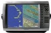
Quick Reference Guide
Page 2
... any time to return to a Man Overboard (MOB) location: 1. To delete an MOB location: 1. Select Review > Delete. To adjust the color mode: 1. Select Day Colors, Night Colors, or Auto. If you have...items. MARK-press to adjust the backlight and color mode. Numeric Keypad (4010/4210/4012/4212 only)-enter numbers and letters into fields instead of the main screens to access ...From the Home screen, select Combinations > Unused Combo (if one chartplotter is available). 2. Garmin®, the Gamin logo, GPSMAP®, BlueChart®, and g2 Vision® are marked with the symbol. 3. or its...
... any time to return to a Man Overboard (MOB) location: 1. To delete an MOB location: 1. Select Review > Delete. To adjust the color mode: 1. Select Day Colors, Night Colors, or Auto. If you have...items. MARK-press to adjust the backlight and color mode. Numeric Keypad (4010/4210/4012/4212 only)-enter numbers and letters into fields instead of the main screens to access ...From the Home screen, select Combinations > Unused Combo (if one chartplotter is available). 2. Garmin®, the Gamin logo, GPSMAP®, BlueChart®, and g2 Vision® are marked with the symbol. 3. or its...
Owner's Manual
Page 12
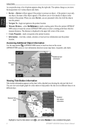
... tide level. When you select Review, you to measure distances. The distance is near the pointer location. Selected item Additional item information Viewing Tide-Station Information Tide-station information appears on -screen map items, waypoints, and charts. Move the pointer (GPSMAP 4000 series) or touch the screen (GPSMAP 5000 series) to view a detailed...
... tide level. When you select Review, you to measure distances. The distance is near the pointer location. Selected item Additional item information Viewing Tide-Station Information Tide-station information appears on -screen map items, waypoints, and charts. Move the pointer (GPSMAP 4000 series) or touch the screen (GPSMAP 5000 series) to view a detailed...
Owner's Manual
Page 22
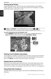
...current graph. Using Charts Note: Use the RANGE (+/-) keys (GPSMAP 4000 series) or touch the and keys (GPSMAP 5000 series) to zoom in your surroundings or to acquaint yourself with the pointer, and select Aerial Photo or Review. To access aerial photos from the Navigation chart: Use the ...ROCKER (GPSMAP 4000 series) or touch the screen (GPSMAP 5000 series) to , these photos to help orient yourself to your BlueChart g2 Vision...
...current graph. Using Charts Note: Use the RANGE (+/-) keys (GPSMAP 4000 series) or touch the and keys (GPSMAP 5000 series) to zoom in your surroundings or to acquaint yourself with the pointer, and select Aerial Photo or Review. To access aerial photos from the Navigation chart: Use the ...ROCKER (GPSMAP 4000 series) or touch the screen (GPSMAP 5000 series) to , these photos to help orient yourself to your BlueChart g2 Vision...
Owner's Manual
Page 28
...comment. Where To? 3. Select Review. (The Review button is only shown when more than one waypoint is in the vicinity.) 3. If using the chart, highlight the new location with the map pointer ( ) (GPSMAP 4000 series) or touch the location (GPSMAP 5000 series), and select Move ...4. Where To? From the Navigation chart, use the map pointer ( ) (GPSMAP 4000 series) or touch the waypoint (GPSMAP 5000 series) to edit. 4. Select the button for the waypoint. Select Review > Delete. 24 GPSMAP® 4000/5000 Series Owner's Manual To move the waypoint on the navigation ...
...comment. Where To? 3. Select Review. (The Review button is only shown when more than one waypoint is in the vicinity.) 3. If using the chart, highlight the new location with the map pointer ( ) (GPSMAP 4000 series) or touch the location (GPSMAP 5000 series), and select Move ...4. Where To? From the Navigation chart, use the map pointer ( ) (GPSMAP 4000 series) or touch the waypoint (GPSMAP 5000 series) to edit. 4. Select the button for the waypoint. Select Review > Delete. 24 GPSMAP® 4000/5000 Series Owner's Manual To move the waypoint on the navigation ...
Owner's Manual
Page 30
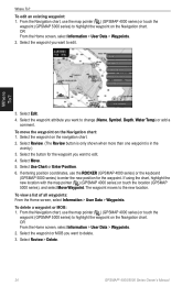
... Home screen, select Information > User Data > Routes. 2. Create a route as a Garmin GHP™ 10), you start any type of the path and selecting Navigate To > Route To. To delete a route: 1. Select Review > Delete. To edit a route: 1. You can change the auto guidance path to ...while creating a route. Where To? 26 GPSMAP® 4000/5000 Series Owner's Manual The auto guidance path stays on a route: 1. Navigating with a Garmin Autopilot When you will be prompted to edit. 3. Select the route to engage the autopilot. Select Review > Edit Route. Select Navigate To > ...
... Home screen, select Information > User Data > Routes. 2. Create a route as a Garmin GHP™ 10), you start any type of the path and selecting Navigate To > Route To. To delete a route: 1. Select Review > Delete. To edit a route: 1. You can change the auto guidance path to ...while creating a route. Where To? 26 GPSMAP® 4000/5000 Series Owner's Manual The auto guidance path stays on a route: 1. Navigating with a Garmin Autopilot When you will be prompted to edit. 3. Select the route to engage the autopilot. Select Review > Edit Route. Select Navigate To > ...
Owner's Manual
Page 38
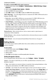
...determine which chartplotter will perform this function for the chartplotter. Marine Network-review all alarms are turned off. Select an alarm category. ...Bridging-output bridging occurs when a chartplotter takes NMEA 0183 data it receives from the Home screen, select Configure > Alarms > Navigation. ...to disable, or select On to change the time or distance. 34 GPSMAP® 4000/5000 Series Owner's Manual Setting Navigation Alarms To set an... the NMEA 0183 output sentence. 4. By default, all connected Garmin Marine Network devices. Select On to turn or destination waypoint. •...
...determine which chartplotter will perform this function for the chartplotter. Marine Network-review all alarms are turned off. Select an alarm category. ...Bridging-output bridging occurs when a chartplotter takes NMEA 0183 data it receives from the Home screen, select Configure > Alarms > Navigation. ...to disable, or select On to change the time or distance. 34 GPSMAP® 4000/5000 Series Owner's Manual Setting Navigation Alarms To set an... the NMEA 0183 output sentence. 4. By default, all connected Garmin Marine Network devices. Select On to turn or destination waypoint. •...
Owner's Manual
Page 42
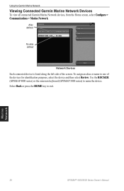
Using the Garmin Marine Network Viewing Connected Garmin Marine Network Devices To view all connected Garmin Marine Network devices, from the Home screen, select Configure > Communications > Marine Network. Marine Network 38 GPSMAP® 4000/5000 Series Owner's Manual To assign an alias or name to one of the screen. Use the ROCKER (GPSMAP 4000 series) or the onscreen keyboard (GPSMAP 5000 series...
Using the Garmin Marine Network Viewing Connected Garmin Marine Network Devices To view all connected Garmin Marine Network devices, from the Home screen, select Configure > Communications > Marine Network. Marine Network 38 GPSMAP® 4000/5000 Series Owner's Manual To assign an alias or name to one of the screen. Use the ROCKER (GPSMAP 4000 series) or the onscreen keyboard (GPSMAP 5000 series...
Owner's Manual
Page 54
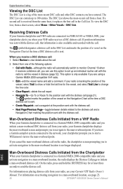
... 2000-compatible radio and you when your Garmin VHF Radio Owner's Manual. For information on placing distress calls from the same boat, it receives a distress call, you can contain up an individual routine call with the radio to call . Select Review to 100 entries. If your radio is sent. If a ...DISTRESS key for the vessel, and select Trail Line to send the distress call , that information is received from your radio, see page 23. 50 GPSMAP® 4000/5000 Series Owner's Manual When you receive a DSC distress call (page 21). The DSC List can use this option to set a waypoint ...
... 2000-compatible radio and you when your Garmin VHF Radio Owner's Manual. For information on placing distress calls from the same boat, it receives a distress call, you can contain up an individual routine call with the radio to call . Select Review to 100 entries. If your radio is sent. If a ...DISTRESS key for the vessel, and select Trail Line to send the distress call , that information is received from your radio, see page 23. 50 GPSMAP® 4000/5000 Series Owner's Manual When you receive a DSC distress call (page 21). The DSC List can use this option to set a waypoint ...
Owner's Manual
Page 56
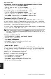
... call to select a different channel from that is sending position reports: 1. Select the station to the radio. 5. DSC 52 GPSMAP® 4000/5000 Series Owner's Manual Select Send to send the information about the call . Select Send to send the information about...the chartplotter interface to set up an individual routine call from the list, and then select Review. 3. Placing an Individual Routine Call When you connect your Garmin chartplotter to a Garmin VHF NMEA 2000-compatible radio, you select a different channel, the chartplotter will use the ...
... call to select a different channel from that is sending position reports: 1. Select the station to the radio. 5. DSC 52 GPSMAP® 4000/5000 Series Owner's Manual Select Send to send the information about the call . Select Send to send the information about...the chartplotter interface to set up an individual routine call from the list, and then select Review. 3. Placing an Individual Routine Call When you connect your Garmin chartplotter to a Garmin VHF NMEA 2000-compatible radio, you select a different channel, the chartplotter will use the ...
Owner's Manual
Page 64
...43 overlay screen 42 surface 12 range 48 Range keys 1 Range Rings 12 registration 57 restoring factory settings 4 review 8 rings 9, 44 roads 18 Rocker 1 Roses 9 routes creating 25 deleting 26 deleting all 30 editing 26...destination by name 22 Service Points 9 settings alarms 34 chart 9 combinations 20 communications 33 fish eye 3D 16 initializing 2 mariner's eye 3D 15 navigation chart 6 sonar 47 sonar (advanced) 48 system 32 simulator mode 4, 32 soft keys i, ...5, 21-26 whiteline 47 wireless devices 34 Z zoom 6, 48 60 GPSMAP® 4000/5000 Series Owner's Manual
...43 overlay screen 42 surface 12 range 48 Range keys 1 Range Rings 12 registration 57 restoring factory settings 4 review 8 rings 9, 44 roads 18 Rocker 1 Roses 9 routes creating 25 deleting 26 deleting all 30 editing 26...destination by name 22 Service Points 9 settings alarms 34 chart 9 combinations 20 communications 33 fish eye 3D 16 initializing 2 mariner's eye 3D 15 navigation chart 6 sonar 47 sonar (advanced) 48 system 32 simulator mode 4, 32 soft keys i, ...5, 21-26 whiteline 47 wireless devices 34 Z zoom 6, 48 60 GPSMAP® 4000/5000 Series Owner's Manual