Owner's Manual
Page 8
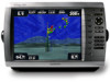
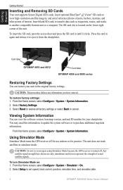
...GPS receiver is located on : 1. Select Factory Settings. 3. Select Reset to restore all factory settings or select Back to purchase additional map data information. Any satellite signal strength bars shown are only simulations and do not represent the strength of interest. From the Home screen, select Configure > System > Simulator > On. 2. Card label GPSMAP 4010... You may need this information to update the system software or to cancel. Select Setup to another compatible Garmin unit or a computer. Insert blank SD cards to transfer data such as waypoints, routes, and tracks ...
...GPS receiver is located on : 1. Select Factory Settings. 3. Select Reset to restore all factory settings or select Back to purchase additional map data information. Any satellite signal strength bars shown are only simulations and do not represent the strength of interest. From the Home screen, select Configure > System > Simulator > On. 2. Card label GPSMAP 4010... You may need this information to update the system software or to cancel. Select Setup to another compatible Garmin unit or a computer. Insert blank SD cards to transfer data such as waypoints, routes, and tracks ...
Owner's Manual
Page 59
... a battery-alarm voltage lower than the unit can read. GPSMAP® 4000/5000 Series Owner's Manual Appendix Deep Water Alarm-(sonar) the boat ...speed wheel for assistance updating your unit software. Can't Unlock Maps-maps are locked and cannot be created. Contact product support. Contact Garmin Product Support for blockage and calibrate again. Enter a number... Software Update Required-an incompatible device is already in the wiring to the remote GPS has been lost satellite reception. Ending position not within safe depth-(BlueChart g2 Vision...
... a battery-alarm voltage lower than the unit can read. GPSMAP® 4000/5000 Series Owner's Manual Appendix Deep Water Alarm-(sonar) the boat ...speed wheel for assistance updating your unit software. Can't Unlock Maps-maps are locked and cannot be created. Contact product support. Contact Garmin Product Support for blockage and calibrate again. Enter a number... Software Update Required-an incompatible device is already in the wiring to the remote GPS has been lost satellite reception. Ending position not within safe depth-(BlueChart g2 Vision...
Owner's Manual
Page 60
...autoguidance has calculated the route, but the end point has been moved to deeper water. GPSMAP® 4000/5000 Series Owner's Manual Off Course Alarm-the boat has left the user-... data transfer. Not All Maps Fit, Some Maps Will Not Be Drawn- Some maps on the end of the track have a clear view of the route have been discarded. Contact Garmin Product Support. Erase existing ... while attempting a user data transfer. Radar Service Lost-(radar) the unit has lost differential GPS reception (WAAS). Tide Alarm-the tide has reached the user-specified tide alarm range. Waypoint...
...autoguidance has calculated the route, but the end point has been moved to deeper water. GPSMAP® 4000/5000 Series Owner's Manual Off Course Alarm-the boat has left the user-... data transfer. Not All Maps Fit, Some Maps Will Not Be Drawn- Some maps on the end of the track have a clear view of the route have been discarded. Contact Garmin Product Support. Erase existing ... while attempting a user data transfer. Radar Service Lost-(radar) the unit has lost differential GPS reception (WAAS). Tide Alarm-the tide has reached the user-specified tide alarm range. Waypoint...
Owner's Manual
Page 63
...communications settings 33 configure 5, 32-36 my boat 35 other boats 36 water speed 36 contact Garmin 57 course up 10 create waypoint 8 creating routes 25 cruising screen (radar) 40 current information...406 37, 39 go to 21 GPS satellite signals 3, 32 GSD 22 37 guide to 21 H Hazard Colors 15 heading 33 Heading Line 10 GPSMAP® 4000/5000 Series Owner's Manual...30 information screen 27 initializing the unit 53 inset map 7, 10 K keel offset 36 L lane width 12 light sectors 11 look-ahd spd 44 M man overboard 23 map datum 33 MapSource data 28 marine network 37 mariner...
...communications settings 33 configure 5, 32-36 my boat 35 other boats 36 water speed 36 contact Garmin 57 course up 10 create waypoint 8 creating routes 25 cruising screen (radar) 40 current information...406 37, 39 go to 21 GPS satellite signals 3, 32 GSD 22 37 guide to 21 H Hazard Colors 15 heading 33 Heading Line 10 GPSMAP® 4000/5000 Series Owner's Manual...30 information screen 27 initializing the unit 53 inset map 7, 10 K keel offset 36 L lane width 12 light sectors 11 look-ahd spd 44 M man overboard 23 map datum 33 MapSource data 28 marine network 37 mariner...
Important Safety and Product Information
Page 2
...it to a professional service, such as a navigational aid. We use a combination of Garmin is to provide customers with California's Proposition 65. If your product has video input capability....visual sightings, local waterway rules and restrictions, and maps. For more information. This Notice is prohibitively expensive. Important Information MAP DATA INFORMATION: One of the goals of governmental...and its components contain chemicals known to the State of certain electronics. Battery Warnings Your GPS unit may use of direction, distance, location, or topography. • If your...
...it to a professional service, such as a navigational aid. We use a combination of Garmin is to provide customers with California's Proposition 65. If your product has video input capability....visual sightings, local waterway rules and restrictions, and maps. For more information. This Notice is prohibitively expensive. Important Information MAP DATA INFORMATION: One of the goals of governmental...and its components contain chemicals known to the State of certain electronics. Battery Warnings Your GPS unit may use of direction, distance, location, or topography. • If your...


