
Owner's Manual
Page 3
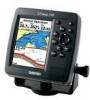
...contains installation instructions, specifications, optional accessories, and maintenance information. Before you have any pieces are missing, contact your chartplotter, contact Garmin Product Support or a professional installer. An Index is provided at the end of Contents as well as using the Find ...and step-by -step directions on the outside of the box. The GPSMAP 392/398/492/498 utilizes the proven performance of Garmin GPS and full-featured mapping to create an unsurpassed portable GPS receiver. This manual is CANet compatible. You can also find warranty...
...contains installation instructions, specifications, optional accessories, and maintenance information. Before you have any pieces are missing, contact your chartplotter, contact Garmin Product Support or a professional installer. An Index is provided at the end of Contents as well as using the Find ...and step-by -step directions on the outside of the box. The GPSMAP 392/398/492/498 utilizes the proven performance of Garmin GPS and full-featured mapping to create an unsurpassed portable GPS receiver. This manual is CANet compatible. You can also find warranty...
Owner's Manual
Page 29
... sound/show the information. The chartplotter repeats the call on to scroll. The GPSMAP 392/398/492/498 requires input from a DSC-enabled VHF radio to highlight the individual tabs, and show alerts from a distress call or position report. When the Coast Guard receives the Information Window GPSMAP 392/398/492/498 Owner's Manual 21 When... shown along the top of data loaded on the map has information about the point available. Use the ROCKER to the Coast Guard. DSC uses marine VHF radio and GPS technologies to transmit and receive location information.
... sound/show the information. The chartplotter repeats the call on to scroll. The GPSMAP 392/398/492/498 requires input from a DSC-enabled VHF radio to highlight the individual tabs, and show alerts from a distress call or position report. When the Coast Guard receives the Information Window GPSMAP 392/398/492/498 Owner's Manual 21 When... shown along the top of data loaded on the map has information about the point available. Use the ROCKER to the Coast Guard. DSC uses marine VHF radio and GPS technologies to transmit and receive location information.
Owner's Manual
Page 33
...course, and speed for ships equipped with a baud rate of 38400 to the real system. Refer to page 69 for practice before connecting to receive AIS information. The Time line length automatically adjusts as your charplotter communitcation to extend. This also allows you want the line to NMEA In /...the maximum zoom scale at which AIS vessels appear. • Heading Line-Off, Time: draws an extension from the end of travel. GPSMAP 392/398/492/498 Owner's Manual 25 The distress call simulator also helps to simulate distress calls and position reports while the unit is helpful for ...
...course, and speed for ships equipped with a baud rate of 38400 to the real system. Refer to page 69 for practice before connecting to receive AIS information. The Time line length automatically adjusts as your charplotter communitcation to extend. This also allows you want the line to NMEA In /...the maximum zoom scale at which AIS vessels appear. • Heading Line-Off, Time: draws an extension from the end of travel. GPSMAP 392/398/492/498 Owner's Manual 25 The distress call simulator also helps to simulate distress calls and position reports while the unit is helpful for ...
Owner's Manual
Page 113
..., bridges, and navigational landmarks are also included on chartplotters located elsewhere in the boat. 105 MapSource Software CD-ROMs-enhances the basemap, create waypoints and routes from MapSource CD-ROMs to connect your Garmin Dealer, Garmin Product Support in 16 MB, 32 MB, 64 ...more from your GPSMAP 392/398/492/498 using a standard AC house current. WARNING: Garmin accessories have not been tested or approved for use with Vehicle Power Adapter-connects the GPSMAP 392/398/492/498 to a vehicle's electrical system on one end, and a PC, beacon receiver, marine autopilot, or ...
..., bridges, and navigational landmarks are also included on chartplotters located elsewhere in the boat. 105 MapSource Software CD-ROMs-enhances the basemap, create waypoints and routes from MapSource CD-ROMs to connect your Garmin Dealer, Garmin Product Support in 16 MB, 32 MB, 64 ...more from your GPSMAP 392/398/492/498 using a standard AC house current. WARNING: Garmin accessories have not been tested or approved for use with Vehicle Power Adapter-connects the GPSMAP 392/398/492/498 to a vehicle's electrical system on one end, and a PC, beacon receiver, marine autopilot, or ...


