
Owner's Manual
Page 80
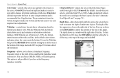
... rate at Normal or 1-100%, the bottom return becomes white with a red line, in a box on page 78.) Depth Line-adds a horizontal depth line across the screen that the transducer sends and receives. It makes the bottom and the fish easier to the objects on this feature. See page 83... reads Off. The depth shows in sonar data presentation and is all the way at the bottom of the range and reads Off. 74 GPSMAP 292/298 Owner's Manual Press up until the setting bar is recommended for more detail on the screen. DynaColor (default) represents the latest in a window on bottom ...
... rate at Normal or 1-100%, the bottom return becomes white with a red line, in a box on page 78.) Depth Line-adds a horizontal depth line across the screen that the transducer sends and receives. It makes the bottom and the fish easier to the objects on this feature. See page 83... reads Off. The depth shows in sonar data presentation and is all the way at the bottom of the range and reads Off. 74 GPSMAP 292/298 Owner's Manual Press up until the setting bar is recommended for more detail on the screen. DynaColor (default) represents the latest in a window on bottom ...

Owner's Manual
Page 84
... is accurate. It makes the bottom and the fish easier to see page 74) with the speed of the Auto Gain. If a GPS ground speed is 30.0 kt. Transducer Type-allows you to specify what colors are applied to ensure that speed produces a 50% scroll rate, ... bottom strength. The unit automatically uses GPS ground speed for all applications. USING SONAR > SONAR TAB OPTIONS Auto Color Gain-controls what type of transducer you reach that the calibration take place in water having little or no current. 78 GPSMAP 292/298 Owner's Manual The higher the setting, the greater...
... is accurate. It makes the bottom and the fish easier to see page 74) with the speed of the Auto Gain. If a GPS ground speed is 30.0 kt. Transducer Type-allows you to specify what colors are applied to ensure that speed produces a 50% scroll rate, ... bottom strength. The unit automatically uses GPS ground speed for all applications. USING SONAR > SONAR TAB OPTIONS Auto Color Gain-controls what type of transducer you reach that the calibration take place in water having little or no current. 78 GPSMAP 292/298 Owner's Manual The higher the setting, the greater...
Owner's Manual
Page 115
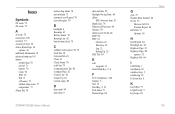
... (bottom) lock 75 C calibrate water speed 78, 79 Card Tab 59 Celestial Tab 45 Chart 62 Clock Alarm 70 color bar 75 Communication Tab 68 Compass Page 32 Course Line 62 Course Up 62 custom range 80 D data cards 94 data entry 6 GPSMAP 292/298 Owner's Manual date and time 95 Daylight Saving Time... Key 5, 8 F FCC Compliance 108 features 5 find 19 Find Key 5, 19 Fish Alarm 71 Flasher Page 84 G gain 73 Garmin Data Transfer 68 Go To 13 Distress Call 24 Position Report 24 GPS Tab 37 Options 39 H hard bottom 84 Heading Line 62 Highway Page 33 Highway Page, 3D options 35 Highway...
... (bottom) lock 75 C calibrate water speed 78, 79 Card Tab 59 Celestial Tab 45 Chart 62 Clock Alarm 70 color bar 75 Communication Tab 68 Compass Page 32 Course Line 62 Course Up 62 custom range 80 D data cards 94 data entry 6 GPSMAP 292/298 Owner's Manual date and time 95 Daylight Saving Time... Key 5, 8 F FCC Compliance 108 features 5 find 19 Find Key 5, 19 Fish Alarm 71 Flasher Page 84 G gain 73 Garmin Data Transfer 68 Go To 13 Distress Call 24 Position Report 24 GPS Tab 37 Options 39 H hard bottom 84 Heading Line 62 Highway Page 33 Highway Page, 3D options 35 Highway...
Owner's Manual
Page 116
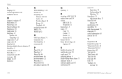
...Points Tab 46 position format 66 position reports 22 Power Key 5 Power On/Off 1 proximity waypoints 50 110 Q Quit Key 5 R receiving a DSC Call 24 replace from card 59 review DSC Call 23 Waypoints 11 Rocker Key 5 routes 17 Copy 51 Create 17 Delete 51...Delete All 51 Routes Tab 51 Route Review Page 52 Options 53 S Satellite Location 95 satellite sky view 95 scroll speed 78 selecting options 6 Shallow/Deep Water Alarm 71 simulator mode 3 software update card 65 soft bottom 84 sonar 72 Depth ...40 Time Format 68 Time Tab 68 time zone 68 tools 75 TracBack 14 Activate 16 GPSMAP 292/298 Owner's Manual
...Points Tab 46 position format 66 position reports 22 Power Key 5 Power On/Off 1 proximity waypoints 50 110 Q Quit Key 5 R receiving a DSC Call 24 replace from card 59 review DSC Call 23 Waypoints 11 Rocker Key 5 routes 17 Copy 51 Create 17 Delete 51...Delete All 51 Routes Tab 51 Route Review Page 52 Options 53 S Satellite Location 95 satellite sky view 95 scroll speed 78 selecting options 6 Shallow/Deep Water Alarm 71 simulator mode 3 software update card 65 soft bottom 84 sonar 72 Depth ...40 Time Format 68 Time Tab 68 time zone 68 tools 75 TracBack 14 Activate 16 GPSMAP 292/298 Owner's Manual
Owner's Manual
Page 117
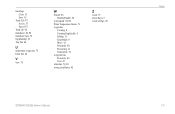
track logs Clear 15 Save 15 Track Tab 57 Active 57 Saved 57 Track Up 62 transducer 82, 90 transducer type 78 trip planning 56 Trip Tab 44 U underwater waypoints 76 Units Tab 66 V view 75 W WAAS 96 Disable/Enable 38 water speed 78, 80 Water Temperature Alarm 71 waypoints Creating 8 Creating Graphically 9 Editing 11 Enter/Mark 8 Move 12 Proximity 50 Reviewing 11 Underwater 76 waypoint lists Proximity 49 User 47 whiteline 74, 83 wiring installation 92 Z zoom 75 Zoom Keys 5 zoom settings 29 GPSMAP 292/298 Owner's Manual INDEX 111
track logs Clear 15 Save 15 Track Tab 57 Active 57 Saved 57 Track Up 62 transducer 82, 90 transducer type 78 trip planning 56 Trip Tab 44 U underwater waypoints 76 Units Tab 66 V view 75 W WAAS 96 Disable/Enable 38 water speed 78, 80 Water Temperature Alarm 71 waypoints Creating 8 Creating Graphically 9 Editing 11 Enter/Mark 8 Move 12 Proximity 50 Reviewing 11 Underwater 76 waypoint lists Proximity 49 User 47 whiteline 74, 83 wiring installation 92 Z zoom 75 Zoom Keys 5 zoom settings 29 GPSMAP 292/298 Owner's Manual INDEX 111

