
Owner's Manual
Page 2
... onto a hard drive or other Garmin products. Visit the Garmin Web site (www.garmin.com) for any storage medium, for current updates and supplemental information concerning the use and operation of such changes or improvements. Garmin reserves the right to change without the express prior written consent of Garmin Ltd. Garmin®, GPSMAP®, AutoLocate® , UltraScroll®...
... onto a hard drive or other Garmin products. Visit the Garmin Web site (www.garmin.com) for any storage medium, for current updates and supplemental information concerning the use and operation of such changes or improvements. Garmin reserves the right to change without the express prior written consent of Garmin Ltd. Garmin®, GPSMAP®, AutoLocate® , UltraScroll®...

Owner's Manual
Page 42
... Page The Active Route Page shows each point from your present location. Refer to indicate the next active point first. Active Route Page 36 GPSMAP 292/298 Owner's Manual The Active Route and Route Review Pages share many of Course, ETA, Fuel, Leg Distance, Leg Fuel, Leg Time, Sunrise, Sunset, or... Time To for information on the Active Route Page, see page 17. As you navigate a route, the waypoint list automatically updates to pages 17-19 for each point of the active route, with an arrow icon.
... Page The Active Route Page shows each point from your present location. Refer to indicate the next active point first. Active Route Page 36 GPSMAP 292/298 Owner's Manual The Active Route and Route Review Pages share many of Course, ETA, Fuel, Leg Distance, Leg Fuel, Leg Time, Sunrise, Sunset, or... Time To for information on the Active Route Page, see page 17. As you navigate a route, the waypoint list automatically updates to pages 17-19 for each point of the active route, with an arrow icon.
Owner's Manual
Page 44
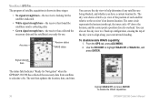
...the sky view to the receiver's last known location. From the GPS tab, press ADJ/MENU. 2. Signal strength bars The status field indicates "Ready for use the sky view to help determine if any satellites are ready for Navigation" when the GPSMAP 292/298 has collected the ...necessary data from satellites to a Track up ), the inner circle 45º above the horizon, and the center point a position directly overhead. To disable/enable WAAS capability: 1. The unit then updates the location, date, and time...
...the sky view to the receiver's last known location. From the GPS tab, press ADJ/MENU. 2. Signal strength bars The status field indicates "Ready for use the sky view to help determine if any satellites are ready for Navigation" when the GPSMAP 292/298 has collected the ...necessary data from satellites to a Track up ), the inner circle 45º above the horizon, and the center point a position directly overhead. To disable/enable WAAS capability: 1. The unit then updates the location, date, and time...

Owner's Manual
Page 48
... tide chart: 1. MAIN MENU > TIDE TAB Viewing Tide Information You can change the date to see tide heights at different times. The tide chart is updated to see tide charts for the selected date. Highlight the tide chart. 2. To view tide heights at various times on the ROCKER to change the.... Using the ROCKER, highlight the On field, and press ENTER. 2. The day changes as you move the time bar in map pointer mode. 42 GPSMAP 292/298 Owner's Manual Move the ROCKER to show tide heights at various times. Enter a date, and press ENTER.
... tide chart: 1. MAIN MENU > TIDE TAB Viewing Tide Information You can change the date to see tide heights at different times. The tide chart is updated to see tide charts for the selected date. Highlight the tide chart. 2. To view tide heights at various times on the ROCKER to change the.... Using the ROCKER, highlight the On field, and press ENTER. 2. The day changes as you move the time bar in map pointer mode. 42 GPSMAP 292/298 Owner's Manual Move the ROCKER to show tide heights at various times. Enter a date, and press ENTER.

Owner's Manual
Page 52
... waypoints quickly and efficiently. Press up or down on the ROCKER to change the time or date: 1. Main Menu tabs Main Menu 46 GPSMAP 292/298 Owner's Manual Press QUIT to highlight Use Current Date and Time, and press ENTER. To use current date and time: From the Celes tab... tabs Celestial Tab Menu To change the days or hours. OR Highlight the On field, and press ENTER. 2. The sub tabs also provide a continuously updated proximity waypoint alarm function that can be used to highlight the Days or Hours button, and press ENTER.
... waypoints quickly and efficiently. Press up or down on the ROCKER to change the time or date: 1. Main Menu tabs Main Menu 46 GPSMAP 292/298 Owner's Manual Press QUIT to highlight Use Current Date and Time, and press ENTER. To use current date and time: From the Celes tab... tabs Celestial Tab Menu To change the days or hours. OR Highlight the On field, and press ENTER. 2. The sub tabs also provide a continuously updated proximity waypoint alarm function that can be used to highlight the Days or Hours button, and press ENTER.
Owner's Manual
Page 71
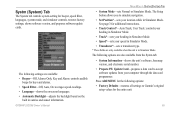
The following settings are only available when the unit is in Simulator Mode. GPSMAP 292/298 Owner's Manual MAIN MENU > SYSTM (SYSTEM) TAB • System Mode-sets Normal or Simulator Mode. The Setup button allows you to simulate ... available from the Systm tab: • System Information-shows the unit's software, basemap version, and electronic serial number. • Prepare SW Update Card-prepares a data card to Garmin's original setup values for beeper, speed filter, languages, system mode, and simulator controls, restores factory settings, shows software version, and...
The following settings are only available when the unit is in Simulator Mode. GPSMAP 292/298 Owner's Manual MAIN MENU > SYSTM (SYSTEM) TAB • System Mode-sets Normal or Simulator Mode. The Setup button allows you to simulate ... available from the Systm tab: • System Information-shows the unit's software, basemap version, and electronic serial number. • Prepare SW Update Card-prepares a data card to Garmin's original setup values for beeper, speed filter, languages, system mode, and simulator controls, restores factory settings, shows software version, and...

Owner's Manual
Page 73
... your unit and external references, such as your current location and press ENTER. GPSMAP 292/298 Owner's Manual Manually enter a magnetic variation. 67 True provides headings based on page 70). • Distance, Speed and Elevation-allows you must periodically update the magnetic variation as a magnetic compass. MAIN MENU > SYSTM (SYSTEM) TAB To enter...
... your unit and external references, such as your current location and press ENTER. GPSMAP 292/298 Owner's Manual Manually enter a magnetic variation. 67 True provides headings based on page 70). • Distance, Speed and Elevation-allows you must periodically update the magnetic variation as a magnetic compass. MAIN MENU > SYSTM (SYSTEM) TAB To enter...

Owner's Manual
Page 82
... the paused screen and cannot show any new sonar data until the standard Sonar Page is resumed. Press ENTER/MARK. Show Map Pointer Option 76 GPSMAP 292/298 Owner's Manual Make your current position. 3. USING SONAR > SONAR PAGE Show/Hide Pointer-allows you want to mark. This makes it starts again.... 2. From the Sonar Page, press ADJ/MENU, highlight Show Pointer, and press ENTER to the standard Sonar Page, press QUIT; The depth is updated while the screen is paused, but the unit does not show an area that has scrolled off the screen. When finished, highlight OK, and...
... the paused screen and cannot show any new sonar data until the standard Sonar Page is resumed. Press ENTER/MARK. Show Map Pointer Option 76 GPSMAP 292/298 Owner's Manual Make your current position. 3. USING SONAR > SONAR PAGE Show/Hide Pointer-allows you want to mark. This makes it starts again.... 2. From the Sonar Page, press ADJ/MENU, highlight Show Pointer, and press ENTER to the standard Sonar Page, press QUIT; The depth is updated while the screen is paused, but the unit does not show an area that has scrolled off the screen. When finished, highlight OK, and...
Owner's Manual
Page 92
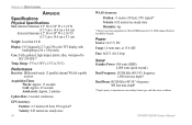
... Display: 5.0" diagonal (12.7 cm) 256-color TFT display with backlighting (234 x 320 pixels) Case: Fully gasketed, high-impact plastic alloy, waterproof to 70°C) Performance Receiver: Differential-ready 12 parallel channel WAAS-capable receiver Acquisition Times: Warm: Approx. 15 seconds Cold: Approx. 45 seconds AutoLocate: Approx. 2 minutes Update Rate: 1/second, continuous GPS Accuracy: Position:
... Display: 5.0" diagonal (12.7 cm) 256-color TFT display with backlighting (234 x 320 pixels) Case: Fully gasketed, high-impact plastic alloy, waterproof to 70°C) Performance Receiver: Differential-ready 12 parallel channel WAAS-capable receiver Acquisition Times: Warm: Approx. 15 seconds Cold: Approx. 45 seconds AutoLocate: Approx. 2 minutes Update Rate: 1/second, continuous GPS Accuracy: Position:
Owner's Manual
Page 108
...to the connected device. Transfer Complete-the unit has finished uploading or downloading information to has either been disconnected or the GPSMAP 292 has lost communication with the sonar device for the most recent data. Modify the waypoint name or delete the existing waypoint. ... software update. Track Log Full-the track log is on . Track Truncated-a complete uploaded track does not fit into memory. If the transducer cable is removed while the unit is full and track recording has been turned off. APPENDIX > MESSAGES Sonar Service Incompatible-(GPSMAP 292 only) ...
...to the connected device. Transfer Complete-the unit has finished uploading or downloading information to has either been disconnected or the GPSMAP 292 has lost communication with the sonar device for the most recent data. Modify the waypoint name or delete the existing waypoint. ... software update. Track Log Full-the track log is on . Track Truncated-a complete uploaded track does not fit into memory. If the transducer cable is removed while the unit is full and track recording has been turned off. APPENDIX > MESSAGES Sonar Service Incompatible-(GPSMAP 292 only) ...
Owner's Manual
Page 116
...Points Tab 46 position format 66 position reports 22 Power Key 5 Power On/Off 1 proximity waypoints 50 110 Q Quit Key 5 R receiving a DSC Call 24 replace from card 59 review DSC Call 23 Waypoints 11 Rocker Key 5 routes 17 Copy 51 Create 17 Delete ... Location 95 satellite sky view 95 scroll speed 78 selecting options 6 Shallow/Deep Water Alarm 71 simulator mode 3 software update card 65 soft bottom 84 sonar 72 Depth Line 74 Understanding 80 Whiteline 74 Sonar Page 72 Adjustment Menu 73 Sonar ... Time Format 68 Time Tab 68 time zone 68 tools 75 TracBack 14 Activate 16 GPSMAP 292/298 Owner's Manual
...Points Tab 46 position format 66 position reports 22 Power Key 5 Power On/Off 1 proximity waypoints 50 110 Q Quit Key 5 R receiving a DSC Call 24 replace from card 59 review DSC Call 23 Waypoints 11 Rocker Key 5 routes 17 Copy 51 Create 17 Delete ... Location 95 satellite sky view 95 scroll speed 78 selecting options 6 Shallow/Deep Water Alarm 71 simulator mode 3 software update card 65 soft bottom 84 sonar 72 Depth Line 74 Understanding 80 Whiteline 74 Sonar Page 72 Adjustment Menu 73 Sonar ... Time Format 68 Time Tab 68 time zone 68 tools 75 TracBack 14 Activate 16 GPSMAP 292/298 Owner's Manual

Owner's Manual
Page 120
or its subsidiaries Garmin International, Inc. 1200 East 151st Street, Olathe, Kansas 66062, USA Garmin (Europe) Ltd. B For the latest free software updates (excluding map data) throughout the life of your Garmin products, visit the Garmin Web site at www.garmin.com. © Copyright 2006 Garmin Ltd. Unit 5, The Quadrangle, Abbey Park Industrial Estate, Romsey, SO51 9DL, UK Garmin Corporation No. 68, Jangshu 2nd Road, Shijr, Taipei County, Taiwan www.garmin.com Part Number 190-00652-00 Rev.
or its subsidiaries Garmin International, Inc. 1200 East 151st Street, Olathe, Kansas 66062, USA Garmin (Europe) Ltd. B For the latest free software updates (excluding map data) throughout the life of your Garmin products, visit the Garmin Web site at www.garmin.com. © Copyright 2006 Garmin Ltd. Unit 5, The Quadrangle, Abbey Park Industrial Estate, Romsey, SO51 9DL, UK Garmin Corporation No. 68, Jangshu 2nd Road, Shijr, Taipei County, Taiwan www.garmin.com Part Number 190-00652-00 Rev.

