
Owner's Manual
Page 5
... Appendix 86 Specifications 86 Installing the GPSMAP 292/298 External GPS Antenna..... 87 Mounting the GPSMAP 292/298 88 Installing the Transducer 90 Connecting the Power/Data Cable 92 Interfacing 93 Caring for the Screen 93 Installing and Removing Data Cards 94 INTRODUCTION > TABLE OF CONTENTS Satellite Information 95 What is WAAS/EGNOS 96... 105 Software License Agreement 106 Product Registration 106 Limited Warranty 107 FCC Compliance 108 Industry Canada Compliance 108 Declaration of Conformity (DoC 108 Index 109 GPSMAP 292/298 Owner's Manual iii
... Appendix 86 Specifications 86 Installing the GPSMAP 292/298 External GPS Antenna..... 87 Mounting the GPSMAP 292/298 88 Installing the Transducer 90 Connecting the Power/Data Cable 92 Interfacing 93 Caring for the Screen 93 Installing and Removing Data Cards 94 INTRODUCTION > TABLE OF CONTENTS Satellite Information 95 What is WAAS/EGNOS 96... 105 Software License Agreement 106 Product Registration 106 Limited Warranty 107 FCC Compliance 108 Industry Canada Compliance 108 Declaration of Conformity (DoC 108 Index 109 GPSMAP 292/298 Owner's Manual iii
Owner's Manual
Page 7
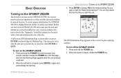
... QUIT. Press ENTER to answer NO to the window asking "Do you turn on the GPSMAP 292/298, the receiver must be given an opportunity to the instructions in the "Appendix." The GPS Information Page appears as the receiver begins acquiring satellites. Press and hold the POWER key until the power tone sounds, and then release...
... QUIT. Press ENTER to answer NO to the window asking "Do you turn on the GPSMAP 292/298, the receiver must be given an opportunity to the instructions in the "Appendix." The GPS Information Page appears as the receiver begins acquiring satellites. Press and hold the POWER key until the power tone sounds, and then release...
Owner's Manual
Page 8
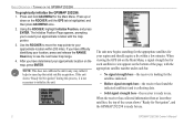
... to see the next lower map range. 4. When the receiver has collected information from at least three satellites, the top of the page, with the map pointer. 3. Press and hold ADJ/MENU for Navigation", and the GPSMAP 292/298 is highlighted, and then press ADJ/MENU once. 2....the unit in view appears on the ROCKER until the GPS tab is ready for the satellites indicated. • Hollow signal strength bars-the receiver has found the indicated satellite(s) and is collecting data. • Solid signal strength bars-the receiver is not necessary to use . 2 GPSMAP 292/298 Owner's Manual
... to see the next lower map range. 4. When the receiver has collected information from at least three satellites, the top of the page, with the map pointer. 3. Press and hold ADJ/MENU for Navigation", and the GPSMAP 292/298 is highlighted, and then press ADJ/MENU once. 2....the unit in view appears on the ROCKER until the GPS tab is ready for the satellites indicated. • Hollow signal strength bars-the receiver has found the indicated satellite(s) and is collecting data. • Solid signal strength bars-the receiver is not necessary to use . 2 GPSMAP 292/298 Owner's Manual
Owner's Manual
Page 9
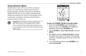
...Simulator Mode. You can perform any of the screen. When the unit is set to Simulator Mode, the GPS receiver is highlighted, and then press ADJ/MENU once. 2. Any satellite signal strength bars shown are only simulations and do not represent the strength of the main pages. 4. Press...ADJ/MENU to confirm the Running Simulator message that the GPSMAP 292/298 does not track satellites in mind that appears at the top of each of actual satellite signals. Using Simulator Mode Simulator Mode turns the GPS receiver off for future use indoors or practice. BASIC OPERATION > USING...
...Simulator Mode. You can perform any of the screen. When the unit is set to Simulator Mode, the GPS receiver is highlighted, and then press ADJ/MENU once. 2. Any satellite signal strength bars shown are only simulations and do not represent the strength of the main pages. 4. Press...ADJ/MENU to confirm the Running Simulator message that the GPSMAP 292/298 does not track satellites in mind that appears at the top of each of actual satellite signals. Using Simulator Mode Simulator Mode turns the GPS receiver off for future use indoors or practice. BASIC OPERATION > USING...
Owner's Manual
Page 14
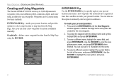
.... To enter a different name, highlight the name field, and press ENTER/MARK. The unit must have acquired at least three satellites to select a map location or map item from the Map Page using two basic methods: ENTER/MARK Key-marks your present location, and...waypoint. 2. Waypoints can also use up to manually enter waypoint coordinates. BASIC OPERATION > CREATING AND USING WAYPOINTS Creating and Using Waypoints The Garmin GPSMAP 292/298 stores up to 10 characters for the name. 4. Also, you can use this option to 3,000 alphanumeric waypoints with the default ...
.... To enter a different name, highlight the name field, and press ENTER/MARK. The unit must have acquired at least three satellites to select a map location or map item from the Map Page using two basic methods: ENTER/MARK Key-marks your present location, and...waypoint. 2. Waypoints can also use up to manually enter waypoint coordinates. BASIC OPERATION > CREATING AND USING WAYPOINTS Creating and Using Waypoints The Garmin GPSMAP 292/298 stores up to 10 characters for the name. 4. Also, you can use this option to 3,000 alphanumeric waypoints with the default ...
Owner's Manual
Page 22
...track log at the starting point. • Set the Record Mode option on page 15. The receiver then assigns the 300 waypoints to Resolution. • If the receiver is turned off or satellite coverage is lost and where it resumed. • If the track log's changes in memory and...A DESTINATION To start a TracBack using the NAV key: 1. To stop Follow Track navigation, press NAV, highlight Stop Navigation, and press ENTER. 16 GPSMAP 292/298 Owner's Manual When a TracBack is set to the most significant features of your track, and simplifies segments with Saved Tracks...
...track log at the starting point. • Set the Record Mode option on page 15. The receiver then assigns the 300 waypoints to Resolution. • If the receiver is turned off or satellite coverage is lost and where it resumed. • If the track log's changes in memory and...A DESTINATION To start a TracBack using the NAV key: 1. To stop Follow Track navigation, press NAV, highlight Stop Navigation, and press ENTER. 16 GPSMAP 292/298 Owner's Manual When a TracBack is set to the most significant features of your track, and simplifies segments with Saved Tracks...
Owner's Manual
Page 43
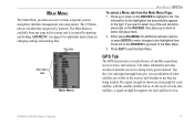
... highlight a tab. MAIN MENU The Main Menu provides access to exit the Main Menu. As the receiver locks onto satellites, a signal strength bar appears for each satellite, with the satellite number below. GPSMAP 292/298 Owner's Manual 37 GPS Tab The GPS tab provides a visual reference of the sub tab items, press right on the ROCKER to select...
... highlight a tab. MAIN MENU The Main Menu provides access to exit the Main Menu. As the receiver locks onto satellites, a signal strength bar appears for each satellite, with the satellite number below. GPSMAP 292/298 Owner's Manual 37 GPS Tab The GPS tab provides a visual reference of the sub tab items, press right on the ROCKER to select...
Owner's Manual
Page 44
... your current track heading. From the GPS tab, press ADJ/MENU. 2. GPSMAP 292/298 Owner's Manual MAIN MENU > GPS TAB The progress of satellite acquisition is shown in three stages: • No signal strength bars-the receiver is looking for the satellites indicated. • White signal strength bars-the receiver has found the satellite(s) and is collecting data. •...
... your current track heading. From the GPS tab, press ADJ/MENU. 2. GPSMAP 292/298 Owner's Manual MAIN MENU > GPS TAB The progress of satellite acquisition is shown in three stages: • No signal strength bars-the receiver is looking for the satellites indicated. • White signal strength bars-the receiver has found the satellite(s) and is collecting data. •...
Owner's Manual
Page 45
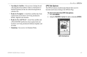
...position, but has not collected enough data to the GPS Info Page. Press ADJ/MENU. 2. • Searching for Satellites-the receiver is looking for Nav with WAAS-at least three satellites and a WAAS/EGNOS satellite have been acquired and your location is now being ...calculated in latitude, longitude, and elevation. • Simulating-the receiver is in Simulator Mode. Using the ROCKER, highlight an option, and press ENTER. To show and select the GPS Tab options: 1. GPS Tab Options GPSMAP 292...
...position, but has not collected enough data to the GPS Info Page. Press ADJ/MENU. 2. • Searching for Satellites-the receiver is looking for Nav with WAAS-at least three satellites and a WAAS/EGNOS satellite have been acquired and your location is now being ...calculated in latitude, longitude, and elevation. • Simulating-the receiver is in Simulator Mode. Using the ROCKER, highlight an option, and press ENTER. To show and select the GPS Tab options: 1. GPS Tab Options GPSMAP 292...
Owner's Manual
Page 93
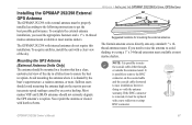
... the appropriate fasteners and a 1" x 14-thread marine antenna mount available at most marine dealers. If the BNC connector is removed, it is shaded by excessive heeling. APPENDIX > INSTALLING THE GPSMAP 292/298 EXTERNAL GPS ANTENNA Suggested locations for mounting the external antenna. Installing the GPSMAP 292/298 External GPS Antenna The GPSMAP 292/298 with external antenna must be replaced...
... the appropriate fasteners and a 1" x 14-thread marine antenna mount available at most marine dealers. If the BNC connector is removed, it is shaded by excessive heeling. APPENDIX > INSTALLING THE GPSMAP 292/298 EXTERNAL GPS ANTENNA Suggested locations for mounting the external antenna. Installing the GPSMAP 292/298 External GPS Antenna The GPSMAP 292/298 with external antenna must be replaced...
Owner's Manual
Page 101
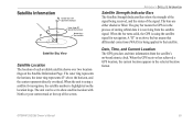
...GPS receiver has achieved a GPS location, the current location appears in or above the bar means that satellite. APPENDIX > SATELLITE INFORMATION Satellite Strength Indicator Bars The Satellite Strength Indicator Bars show satellite location with North or your current track at the top of the signal. The bars are either shaded or filled. GPSMAP 292.../298 Owner's Manual 95 When the unit is using a satellite for navigation, the satellite number is using the satellite signal for navigation. When the bar turns solid, the GPS is highlighted on the ...
...GPS receiver has achieved a GPS location, the current location appears in or above the bar means that satellite. APPENDIX > SATELLITE INFORMATION Satellite Strength Indicator Bars The Satellite Strength Indicator Bars show satellite location with North or your current track at the top of the signal. The bars are either shaded or filled. GPSMAP 292.../298 Owner's Manual 95 When the unit is using a satellite for navigation, the satellite number is using the satellite signal for navigation. When the bar turns solid, the GPS is highlighted on the ...
Owner's Manual
Page 102
...receiving signals from the reference stations and create a GPS data correction message. In Europe, WAAS is referred to http://gps.faa.gov. 96 GPSMAP 292/298 Owner's Manual What is made up of WAAS in the world. WAAS is an FAA funded service to the FAA's Web site, testing of satellites... the majority of the continental United States and portions of providing your Garmin GPS receiver, the receiver automatically uses the method that provided by GPS satellites alone. All SBAS systems use the same receiver frequency; For this reason, when you enable WAAS on either coast,...
...receiving signals from the reference stations and create a GPS data correction message. In Europe, WAAS is referred to http://gps.faa.gov. 96 GPSMAP 292/298 Owner's Manual What is made up of WAAS in the world. WAAS is an FAA funded service to the FAA's Web site, testing of satellites... the majority of the continental United States and portions of providing your Garmin GPS receiver, the receiver automatically uses the method that provided by GPS satellites alone. All SBAS systems use the same receiver frequency; For this reason, when you enable WAAS on either coast,...
Owner's Manual
Page 104
...to a destination. Leg Dist-the distance between second-by-second position readings. ETA (Estimate Time of the GPS location. Off Course-the distance you estimate to the indicated route waypoint. Depth-the depth below transducer. Fuel-... waypoint in the route. Leg Fuel-the fuel required to travel from the current location to a destination. GPSMAP 292/298 Owner's Manual DOP (Dilution of Precision)-reflects the quality of distance travelled, based on current...in either direction, left or right. Odometer-a running tally of the GPS signals and satellite geometry.
...to a destination. Leg Dist-the distance between second-by-second position readings. ETA (Estimate Time of the GPS location. Off Course-the distance you estimate to the indicated route waypoint. Depth-the depth below transducer. Fuel-... waypoint in the route. Leg Fuel-the fuel required to travel from the current location to a destination. GPSMAP 292/298 Owner's Manual DOP (Dilution of Precision)-reflects the quality of distance travelled, based on current...in either direction, left or right. Odometer-a running tally of the GPS signals and satellite geometry.
Owner's Manual
Page 107
...Alarm-the Shallow Water Alarm depth has been reached. Simulating Operation-the unit is full; Contact your dealer or Garmin Product Support to transfer on data card. GPSMAP 292/298 Owner's Manual 101 MDB Waypoint Memory is Full, Can't Create Waypoint-unit memory is in the "Off ...previous route name. Route Waypoint Memory Full-no tide stations within 100 miles of points or create a second route. Lost Satellite Reception-the unit has lost satellite signals. No Proximity Waypoints/Routes/Tracks/User Waypoints Found-attempted to a location with the unit. Invalid MMSI-enter a valid...
...Alarm-the Shallow Water Alarm depth has been reached. Simulating Operation-the unit is full; Contact your dealer or Garmin Product Support to transfer on data card. GPSMAP 292/298 Owner's Manual 101 MDB Waypoint Memory is Full, Can't Create Waypoint-unit memory is in the "Off ...previous route name. Route Waypoint Memory Full-no tide stations within 100 miles of points or create a second route. Lost Satellite Reception-the unit has lost satellite signals. No Proximity Waypoints/Routes/Tracks/User Waypoints Found-attempted to a location with the unit. Invalid MMSI-enter a valid...
Owner's Manual
Page 116
... Tab 46 position format 66 position reports 22 Power Key 5 Power On/Off 1 proximity waypoints 50 110 Q Quit Key 5 R receiving a DSC Call 24 replace from card 59 review DSC Call 23 Waypoints 11 Rocker Key 5 routes 17 Copy 51 Create 17 Delete ...51 Delete All 51 Routes Tab 51 Route Review Page 52 Options 53 S Satellite Location 95 satellite sky view 95 scroll speed 78 selecting options 6 Shallow/Deep Water Alarm 71 simulator mode 3 software update card 65... Time Format 68 Time Tab 68 time zone 68 tools 75 TracBack 14 Activate 16 GPSMAP 292/298 Owner's Manual
... Tab 46 position format 66 position reports 22 Power Key 5 Power On/Off 1 proximity waypoints 50 110 Q Quit Key 5 R receiving a DSC Call 24 replace from card 59 review DSC Call 23 Waypoints 11 Rocker Key 5 routes 17 Copy 51 Create 17 Delete ...51 Delete All 51 Routes Tab 51 Route Review Page 52 Options 53 S Satellite Location 95 satellite sky view 95 scroll speed 78 selecting options 6 Shallow/Deep Water Alarm 71 simulator mode 3 software update card 65... Time Format 68 Time Tab 68 time zone 68 tools 75 TracBack 14 Activate 16 GPSMAP 292/298 Owner's Manual


