
Flush Mount Template
Page 1
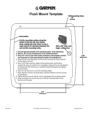
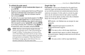
...-00658-02 Rev. Place the unit into the back of clearance between the unit and the mounting holes. Drill a 3/8" hole, and begin cutting here. 1. Avoid cable areas. 2. Drill a 3/8" (10 mm) hole at the indicated locations. 3.
...-00658-02 Rev. Place the unit into the back of clearance between the unit and the mounting holes. Drill a 3/8" hole, and begin cutting here. 1. Avoid cable areas. 2. Drill a 3/8" (10 mm) hole at the indicated locations. 3.
Owner's Manual
Page 5
... Sonar 80 Flasher Page 84 Map Split Page 85 Appendix 86 Specifications 86 Installing the GPSMAP 292/298 External GPS Antenna..... 87 Mounting the GPSMAP 292/298 88 Installing the Transducer 90 Connecting the Power/Data Cable 92 Interfacing 93 Caring for the Screen 93 Installing and Removing Data Cards 94 INTRODUCTION > TABLE OF... 105 Software License Agreement 106 Product Registration 106 Limited Warranty 107 FCC Compliance 108 Industry Canada Compliance 108 Declaration of Conformity (DoC 108 Index 109 GPSMAP 292/298 Owner's Manual iii
... Sonar 80 Flasher Page 84 Map Split Page 85 Appendix 86 Specifications 86 Installing the GPSMAP 292/298 External GPS Antenna..... 87 Mounting the GPSMAP 292/298 88 Installing the Transducer 90 Connecting the Power/Data Cable 92 Interfacing 93 Caring for the Screen 93 Installing and Removing Data Cards 94 INTRODUCTION > TABLE OF... 105 Software License Agreement 106 Product Registration 106 Limited Warranty 107 FCC Compliance 108 Industry Canada Compliance 108 Declaration of Conformity (DoC 108 Index 109 GPSMAP 292/298 Owner's Manual iii
Owner's Manual
Page 27
...about the point available. Digital Selective Calling (DSC) uses marine VHF radio and Global Positioning System (GPS) technologies to "Connecting the Power/Data Cable" on the optional data card. Sub tabs along the bottom. The GPSMAP 292/298 requires input from a DSC enabled VHF radio to ... and press ENTER. For connection information, refer to transmit and receive location information. Information Window GPSMAP 292/298 Owner's Manual 21 When any nearby rescuer receives the DSC signal, an alarm sounds and they immediately receive the location of the Main Menu controls and sets up the...
...about the point available. Digital Selective Calling (DSC) uses marine VHF radio and Global Positioning System (GPS) technologies to "Connecting the Power/Data Cable" on the optional data card. Sub tabs along the bottom. The GPSMAP 292/298 requires input from a DSC enabled VHF radio to ... and press ENTER. For connection information, refer to transmit and receive location information. Information Window GPSMAP 292/298 Owner's Manual 21 When any nearby rescuer receives the DSC signal, an alarm sounds and they immediately receive the location of the Main Menu controls and sets up the...
Owner's Manual
Page 53
... is deleted from the list, it cannot be recovered from the Points tab is highlighted. Use the ROCKER to a computer using an optional PC cable and interface software or record them manually. Press down on the ROCKER until a waypoint is the User list, which shows a master list of ... the Points (Waypoint) sub tab: 1. A list of the Main Menu list. 2. MAIN MENU > POINTS TAB The following options are available from the unit. GPSMAP 292/298 Owner's Manual 47 Press right one time on the Points tab: • New Waypoint-allows you can review, edit, rename or delete individual waypoints...
... is deleted from the list, it cannot be recovered from the Points tab is highlighted. Use the ROCKER to a computer using an optional PC cable and interface software or record them manually. Press down on the ROCKER until a waypoint is the User list, which shows a master list of ... the Points (Waypoint) sub tab: 1. A list of the Main Menu list. 2. MAIN MENU > POINTS TAB The following options are available from the unit. GPSMAP 292/298 Owner's Manual 47 Press right one time on the Points tab: • New Waypoint-allows you can review, edit, rename or delete individual waypoints...
Owner's Manual
Page 85
Both the top GPS ground speed and uncalibrated water speed appear at the bottom of the screen. NOTE: If the boat is not moving or safely increase boat speed. ... as above with the target depth shown. If a ground speed is not available, the top uncalibrated water speed is correct, highlight OK, and press ENTER. GPSMAP 292/298 Owner's Manual 79 If there is not registering a speed, a "Boat Is Not Moving Fast Enough To Calibrate" message appears at the bottom of the...
Both the top GPS ground speed and uncalibrated water speed appear at the bottom of the screen. NOTE: If the boat is not moving or safely increase boat speed. ... as above with the target depth shown. If a ground speed is not available, the top uncalibrated water speed is correct, highlight OK, and press ENTER. GPSMAP 292/298 Owner's Manual 79 If there is not registering a speed, a "Boat Is Not Moving Fast Enough To Calibrate" message appears at the bottom of the...
Owner's Manual
Page 93
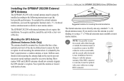
... the antenna high on the coaxial cable and the coaxial cable shortened to avoid shading, try using a 1" x 14-thread extension mast available at most marine dealers. The GPSMAP 292/298 with harsh solvents. APPENDIX > INSTALLING THE GPSMAP 292/298 EXTERNAL GPS ANTENNA Suggested locations for mounting the ...it must be replaced with external antenna must be mounted in all directions to get the best possible performance. The Garmin antenna screws directly onto any standard 1" x 14thread antenna mount. To complete the external antenna installation, you need the appropriate fasteners ...
... the antenna high on the coaxial cable and the coaxial cable shortened to avoid shading, try using a 1" x 14-thread extension mast available at most marine dealers. The GPSMAP 292/298 with harsh solvents. APPENDIX > INSTALLING THE GPSMAP 292/298 EXTERNAL GPS ANTENNA Suggested locations for mounting the ...it must be replaced with external antenna must be mounted in all directions to get the best possible performance. The Garmin antenna screws directly onto any standard 1" x 14thread antenna mount. To complete the external antenna installation, you need the appropriate fasteners ...
Owner's Manual
Page 94
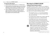
APPENDIX > MOUNTING THE GPSMAP 292/298 To install the GPS antenna: 1. Make sure that you consider the following conditions: • There should be at the nav station. The unit comes with the built-in internal antenna, should be used for the GPSMAP 292/298 is 5°F to 158°F (-15°C to lock the cable into place...
APPENDIX > MOUNTING THE GPSMAP 292/298 To install the GPS antenna: 1. Make sure that you consider the following conditions: • There should be at the nav station. The unit comes with the built-in internal antenna, should be used for the GPSMAP 292/298 is 5°F to 158°F (-15°C to lock the cable into place...
Owner's Manual
Page 97
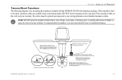
... waterline. GPSMAP 292/298 Owner's Manual 91 If the transducer lead is in the path of the transducer cable, as this will void your Garmin dealer. It is important that the transducer is below aluminum hull Make sure that the transducer is too short, extension cables are available from seeping into the transom. Apply marine sealant...
... waterline. GPSMAP 292/298 Owner's Manual 91 If the transducer lead is in the path of the transducer cable, as this will void your Garmin dealer. It is important that the transducer is below aluminum hull Make sure that the transducer is too short, extension cables are available from seeping into the transom. Apply marine sealant...
Owner's Manual
Page 98
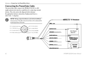
... for normal operation of the unit. Orange (Accessory On) DC Positive (CANet L) (CANet H) (RX NMEA) (TX NMEA) Accessory On DC Power Source CANet L CANet H 92 GPSMAP 292/298 Owner's Manual APPENDIX > CONNECTING THE POWER/DATA CABLE Connecting the Power/Data Cable The power/data cable connects the GPSMAP 292/298 to be connected for connecting external devices.
... for normal operation of the unit. Orange (Accessory On) DC Positive (CANet L) (CANet H) (RX NMEA) (TX NMEA) Accessory On DC Power Source CANet L CANet H 92 GPSMAP 292/298 Owner's Manual APPENDIX > CONNECTING THE POWER/DATA CABLE Connecting the Power/Data Cable The power/data cable connects the GPSMAP 292/298 to be connected for connecting external devices.
Owner's Manual
Page 108
...or delete the existing waypoint. The oldest track log points were deleted to make space for new entries. 102 GPSMAP 292/298 Owner's Manual If the transducer cable is removed while the unit is full and track recording has been turned off. Track Truncated-a complete uploaded track ...does not fit into memory. APPENDIX > MESSAGES Sonar Service Incompatible-(GPSMAP 292 only) the external sonar device you have used all 3,...
...or delete the existing waypoint. The oldest track log points were deleted to make space for new entries. 102 GPSMAP 292/298 Owner's Manual If the transducer cable is removed while the unit is full and track recording has been turned off. Track Truncated-a complete uploaded track ...does not fit into memory. APPENDIX > MESSAGES Sonar Service Incompatible-(GPSMAP 292 only) the external sonar device you have used all 3,...
Owner's Manual
Page 111
...800-800-1020, or Garmin Europe at high speed through your PC. MapSource Software CD-ROMs-enhances the basemap, create waypoints and routes from MapSource CD-ROMs to a vehicle's electrical system on one end, and a PC, beacon receiver, marine autopilot, or other ... Adapter-connects the GPSMAP 292/298 to a data card, either Garmin BlueChart or Fishing Hot Spots map data. PC Interface Cable with Garmin products. Full-color aerial photos of interest, business addresses and phone numbers, marine data, topographical information, and more . WARNING: Garmin accessories have not ...
...800-800-1020, or Garmin Europe at high speed through your PC. MapSource Software CD-ROMs-enhances the basemap, create waypoints and routes from MapSource CD-ROMs to a vehicle's electrical system on one end, and a PC, beacon receiver, marine autopilot, or other ... Adapter-connects the GPSMAP 292/298 to a data card, either Garmin BlueChart or Fishing Hot Spots map data. PC Interface Cable with Garmin products. Full-color aerial photos of interest, business addresses and phone numbers, marine data, topographical information, and more . WARNING: Garmin accessories have not ...


