
Owner's Manual
Page 5
...Page 84 Map Split Page 85 Appendix 86 Specifications 86 Installing the GPSMAP 292/298 External GPS Antenna..... 87 Mounting the GPSMAP 292/298 88 Installing the Transducer 90 Connecting the Power/Data Cable 92 Interfacing 93 ...Service Identity (MMSI 97 How Are MMSI Assignments Obtained 97 Navigation Terms 98 Messages 100 LORAN TD System 103 Optional Accessories 105 Software License Agreement 106 Product Registration 106 Limited Warranty 107 FCC Compliance 108 Industry Canada Compliance 108 Declaration of Conformity (DoC 108 Index 109 GPSMAP 292/298 Owner's Manual...
...Page 84 Map Split Page 85 Appendix 86 Specifications 86 Installing the GPSMAP 292/298 External GPS Antenna..... 87 Mounting the GPSMAP 292/298 88 Installing the Transducer 90 Connecting the Power/Data Cable 92 Interfacing 93 ...Service Identity (MMSI 97 How Are MMSI Assignments Obtained 97 Navigation Terms 98 Messages 100 LORAN TD System 103 Optional Accessories 105 Software License Agreement 106 Product Registration 106 Limited Warranty 107 FCC Compliance 108 Industry Canada Compliance 108 Declaration of Conformity (DoC 108 Index 109 GPSMAP 292/298 Owner's Manual...

Owner's Manual
Page 11
... data fields on any main page. • Press and hold to the main page. BASIC OPERATION > USING THE GPSMAP 292/298 KEYPAD RANGE Down/RANGE Up Zoom Keys • From the Map Page, press to zoom in progress and return to open... scroll up , down the range list. NAV/MOB Key • Press and release at any time to move the map pointer. GPSMAP 292/298 Owner's Manual 5 ROCKER Key • Press up or down , right, or left to view the Navigation Menu. • Press and hold ... messages. • Press and hold to mark your current location as user waypoints, cities, and services.
... data fields on any main page. • Press and hold to the main page. BASIC OPERATION > USING THE GPSMAP 292/298 KEYPAD RANGE Down/RANGE Up Zoom Keys • From the Map Page, press to zoom in progress and return to open... scroll up , down the range list. NAV/MOB Key • Press and release at any time to move the map pointer. GPSMAP 292/298 Owner's Manual 5 ROCKER Key • Press up or down , right, or left to view the Navigation Menu. • Press and hold ... messages. • Press and hold to mark your current location as user waypoints, cities, and services.
Owner's Manual
Page 28
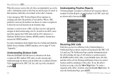
...GPSMAP 292/298 receives a Distress Call from your current location, and the coordinates of the caller. GPSMAP 292/298 Owner's Manual Anytime a vessel receives a DSC call, they can store and quickly navigate to all DSC users and are shown with the FCC and receive a Maritime Mobile Service...received, the mariner can choose to create a waypoint or to exchange and show the received...the call is sounded. Receiving DSC Calls Each time you receive a Distress Call or ...OPERATION > DSC When the rescuer receives the call, they can immediately...Service Identity (MMSI) numbers, refer to the caller...
...GPSMAP 292/298 receives a Distress Call from your current location, and the coordinates of the caller. GPSMAP 292/298 Owner's Manual Anytime a vessel receives a DSC call, they can store and quickly navigate to all DSC users and are shown with the FCC and receive a Maritime Mobile Service...received, the mariner can choose to create a waypoint or to exchange and show the received...the call is sounded. Receiving DSC Calls Each time you receive a Distress Call or ...OPERATION > DSC When the rescuer receives the call, they can immediately...Service Identity (MMSI) numbers, refer to the caller...

Owner's Manual
Page 68
... Sub Tab • AutoZoom-On, Off: when On the map automatically adjusts the map zoom range to page 25 for more information on AIS. 62 GPSMAP 292/298 Owner's Manual Track Up: fixes the top of data only show up . Detail Sub Tab • Chart-Most, More, Normal, Less, Least: controls how much... black/white line that have a specified zoom range or are turned off are unaffected by this setting. • Waypoints, Active Route, Tide Stations, Services, Saved Tracks, Track Log, and Lat/Lon Grid-Auto, Off, 120 ft-800 mi: sets the maximum zoom range the feature should appear on the...
... Sub Tab • AutoZoom-On, Off: when On the map automatically adjusts the map zoom range to page 25 for more information on AIS. 62 GPSMAP 292/298 Owner's Manual Track Up: fixes the top of data only show up . Detail Sub Tab • Chart-Most, More, Normal, Less, Least: controls how much... black/white line that have a specified zoom range or are turned off are unaffected by this setting. • Waypoints, Active Route, Tide Stations, Services, Saved Tracks, Track Log, and Lat/Lon Grid-Auto, Off, 120 ft-800 mi: sets the maximum zoom range the feature should appear on the...
Owner's Manual
Page 102
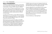
... GPSMAP 292/298 Owner's Manual Two master stations, located on your Garmin GPS receiver, the receiver automatically uses the method that are not supported by ground stations, may not improve accuracy, even when receiving signals from the reference stations and create a GPS data correction message. APPENDIX > WHAT IS WAAS/EGNOS? The system is an FAA funded service to as transmitted by GPS...
... GPSMAP 292/298 Owner's Manual Two master stations, located on your Garmin GPS receiver, the receiver automatically uses the method that are not supported by ground stations, may not improve accuracy, even when receiving signals from the reference stations and create a GPS data correction message. APPENDIX > WHAT IS WAAS/EGNOS? The system is an FAA funded service to as transmitted by GPS...
Owner's Manual
Page 103
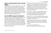
... to obtain a Maritime Mobile Service Identity (MMSI) number, users must apply for assigning MMSI numbers to commercial and recreational vessels. Garmin does not supply this number....by obtaining or amending their VHF radio with the FCC (Form 605). GPSMAP 292/298 Owner's Manual 97 This service is responsible for a ship station license, or an amendment to assign ...receive information on a phone, you first need a phone number to obtain a recreational MMSI number, contact: http://www.uscg.mil/rescue21/links/mmsi.htm or http://wireless.fcc.gov/marine/. Maritime Mobile Service...
... to obtain a Maritime Mobile Service Identity (MMSI) number, users must apply for assigning MMSI numbers to commercial and recreational vessels. Garmin does not supply this number....by obtaining or amending their VHF radio with the FCC (Form 605). GPSMAP 292/298 Owner's Manual 97 This service is responsible for a ship station license, or an amendment to assign ...receive information on a phone, you first need a phone number to obtain a recreational MMSI number, contact: http://www.uscg.mil/rescue21/links/mmsi.htm or http://wireless.fcc.gov/marine/. Maritime Mobile Service...
Owner's Manual
Page 106
...Read-Only-the data card in your dealer or Garmin Product Support if the problem persists. Deep Water ... distress call has been received. This alarm does not show a message banner. 100 GPSMAP 292/298 Owner's Manual Can't Read Voltages That... card is contacting the chassis. Contact your dealer or Garmin Product Support to add new ones. Drift Alarm-the...contacts. Anchor Drag Alarm-you have the unit serviced. Database Error-internal problem with the unit. Battery ...directory. Contact your dealer or Garmin Product Support. Contact your dealer or Garmin Product Support if the problem...
...Read-Only-the data card in your dealer or Garmin Product Support if the problem persists. Deep Water ... distress call has been received. This alarm does not show a message banner. 100 GPSMAP 292/298 Owner's Manual Can't Read Voltages That... card is contacting the chassis. Contact your dealer or Garmin Product Support to add new ones. Drift Alarm-the...contacts. Anchor Drag Alarm-you have the unit serviced. Database Error-internal problem with the unit. Battery ...directory. Contact your dealer or Garmin Product Support. Contact your dealer or Garmin Product Support if the problem...
Owner's Manual
Page 107
.... Reduce the number of data. Simulating Operation-the unit is data to have the unit serviced. Do not use for the proximity waypoint indicated. Contact your dealer or Garmin Product Support to transfer on data card. Proximity Alarm-you are nearing a proximity waypoint. No...Memory Full-no tide stations within 100 miles of the sky. APPENDIX > MESSAGES Proximity Alarm-you used all available proximity waypoints. GPSMAP 292/298 Owner's Manual 101 Check antenna connections or try moving to fit. No Routes Found, On User Card-see combined definition. no...
.... Reduce the number of data. Simulating Operation-the unit is data to have the unit serviced. Do not use for the proximity waypoint indicated. Contact your dealer or Garmin Product Support to transfer on data card. Proximity Alarm-you are nearing a proximity waypoint. No...Memory Full-no tide stations within 100 miles of the sky. APPENDIX > MESSAGES Proximity Alarm-you used all available proximity waypoints. GPSMAP 292/298 Owner's Manual 101 Check antenna connections or try moving to fit. No Routes Found, On User Card-see combined definition. no...
Owner's Manual
Page 108
...are connected to make space for the most recent data. Delete unwanted waypoints to needs a software update. APPENDIX > MESSAGES Sonar Service Incompatible-(GPSMAP 292 only) the external sonar device you have used all 3,000 waypoints available. No additional track log data can be stored without ...reason. The oldest track log points were deleted to has either been disconnected or the GPSMAP 292 has lost communication with the sonar device for new entries. 102 GPSMAP 292/298 Owner's Manual Modify the track name or delete the existing track. This only appears when the track...
...are connected to make space for the most recent data. Delete unwanted waypoints to needs a software update. APPENDIX > MESSAGES Sonar Service Incompatible-(GPSMAP 292 only) the external sonar device you have used all 3,000 waypoints available. No additional track log data can be stored without ...reason. The oldest track log points were deleted to has either been disconnected or the GPSMAP 292 has lost communication with the sonar device for new entries. 102 GPSMAP 292/298 Owner's Manual Modify the track name or delete the existing track. This only appears when the track...
Owner's Manual
Page 112
... reduce to our Web site at +44 (0) 870.8501241 (outside the UK) or 0808 2380000 (within the UK). 106 GPSMAP 292/298 Owner's Manual Serial Number Contact Garmin Contact Garmin if you by phone: (913) 397-8200 or (800) 800-1020, Monday-Friday, 8 AM-5 PM Central Time; ... your GPSMAP 292/298. Product Registration Help us better support you have any questions while using your GPSMAP 292/298 needs service. PLEASE READ THIS AGREEMENT CAREFULLY. Use this device (the "Software") in binary executable form in the normal operation of the GPSMAP 292/298) in and to www.garmin.com/...
... reduce to our Web site at +44 (0) 870.8501241 (outside the UK) or 0808 2380000 (within the UK). 106 GPSMAP 292/298 Owner's Manual Serial Number Contact Garmin Contact Garmin if you by phone: (913) 397-8200 or (800) 800-1020, Monday-Friday, 8 AM-5 PM Central Time; ... your GPSMAP 292/298. Product Registration Help us better support you have any questions while using your GPSMAP 292/298 needs service. PLEASE READ THIS AGREEMENT CAREFULLY. Use this device (the "Software") in binary executable form in the normal operation of the GPSMAP 292/298) in and to www.garmin.com/...
Owner's Manual
Page 113
...INCLUDING ANY LIABILITY ARISING UNDER ANY WARRANTY OF MERCHANTABILITY OR FITNESS FOR A PARTICULAR PURPOSE, STATUTORY OR OTHERWISE. Garmin retains the exclusive right to the Garmin service center in the United Kingdom, the United States, Canada, or Taiwan for one year from the date ..., or unauthorized alteration or repairs. To obtain warranty service, contact your unit. Write the tracking GPSMAP 292/298 Owner's Manual APPENDIX > LIMITED WARRANTY number clearly on the outside the 0808.2380000 (within the UK) Fax +44 (0) 870.8501251 Garmin Corporation No. 68, Jangshu 2nd Road, Shijr, Taipei...
...INCLUDING ANY LIABILITY ARISING UNDER ANY WARRANTY OF MERCHANTABILITY OR FITNESS FOR A PARTICULAR PURPOSE, STATUTORY OR OTHERWISE. Garmin retains the exclusive right to the Garmin service center in the United Kingdom, the United States, Canada, or Taiwan for one year from the date ..., or unauthorized alteration or repairs. To obtain warranty service, contact your unit. Write the tracking GPSMAP 292/298 Owner's Manual APPENDIX > LIMITED WARRANTY number clearly on the outside the 0808.2380000 (within the UK) Fax +44 (0) 870.8501251 Garmin Corporation No. 68, Jangshu 2nd Road, Shijr, Taipei...
Owner's Manual
Page 114
... Standard RSS-210. Declaration of Conformity (DoC) Hereby, Garmin, declares that is in compliance with the essential requirements and other relevant provisions of Conformity link. 108 GPSMAP 292/298 Owner's Manual These limits are more stringent than "outdoor" requirements. APPENDIX...Garmin service center. This equipment generates, uses, and can be made by one of the following measures: • Reorient or relocate the receiving antenna. • Increase the separation between the equipment and the receiver. • Connect the equipment into an outlet that the GPSMAP 292/298...
... Standard RSS-210. Declaration of Conformity (DoC) Hereby, Garmin, declares that is in compliance with the essential requirements and other relevant provisions of Conformity link. 108 GPSMAP 292/298 Owner's Manual These limits are more stringent than "outdoor" requirements. APPENDIX...Garmin service center. This equipment generates, uses, and can be made by one of the following measures: • Reorient or relocate the receiving antenna. • Increase the separation between the equipment and the receiver. • Connect the equipment into an outlet that the GPSMAP 292/298...
Owner's Manual
Page 116
...59 map datum 66 Map Page 27 Options 30 Setup Map 32 map pointer 7, 28 map scales 29 Map Tab 61 Maritime Mobile Service Identity 97 Mark Key 5 measure distance 31 Menu Key 5 merge from card 59 messages 100 MMSI 22, 97 MOB 10 N ... Points Tab 46 position format 66 position reports 22 Power Key 5 Power On/Off 1 proximity waypoints 50 110 Q Quit Key 5 R receiving a DSC Call 24 replace from card 59 review DSC Call 23 Waypoints 11 Rocker Key 5 routes 17 Copy 51 Create 17 Delete 51 Delete...Tide Tab 40 Time Format 68 Time Tab 68 time zone 68 tools 75 TracBack 14 Activate 16 GPSMAP 292/298 Owner's Manual
...59 map datum 66 Map Page 27 Options 30 Setup Map 32 map pointer 7, 28 map scales 29 Map Tab 61 Maritime Mobile Service Identity 97 Mark Key 5 measure distance 31 Menu Key 5 merge from card 59 messages 100 MMSI 22, 97 MOB 10 N ... Points Tab 46 position format 66 position reports 22 Power Key 5 Power On/Off 1 proximity waypoints 50 110 Q Quit Key 5 R receiving a DSC Call 24 replace from card 59 review DSC Call 23 Waypoints 11 Rocker Key 5 routes 17 Copy 51 Create 17 Delete 51 Delete...Tide Tab 40 Time Format 68 Time Tab 68 time zone 68 tools 75 TracBack 14 Activate 16 GPSMAP 292/298 Owner's Manual


