
Pilot's Guide
Page 3
...Garmin GPSMAP® 196, an unsurpassed portable aviation receiver that utilizes the proven performance of Contents. About This Manual To get the most out of your new navigation system, take time to avoid unsafe practices. The Basic Operation in Aviation Mode section provides you with information about navigating with the GPSMAP 196... found in Water Mode section provides you to read this package with the GPSMAP 196 in Land Mode. This manual uses the term Caution to the Aviation and Land sections. GPSMAP 196 Pilot's Guide i The Basic Operation in Land Mode section provides you with...
...Garmin GPSMAP® 196, an unsurpassed portable aviation receiver that utilizes the proven performance of Contents. About This Manual To get the most out of your new navigation system, take time to avoid unsafe practices. The Basic Operation in Aviation Mode section provides you with information about navigating with the GPSMAP 196... found in Water Mode section provides you to read this package with the GPSMAP 196 in Land Mode. This manual uses the term Caution to the Aviation and Land sections. GPSMAP 196 Pilot's Guide i The Basic Operation in Land Mode section provides you with...

Pilot's Guide
Page 9
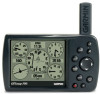
GETTING STARTED GETTING STARTED > UNIT OVERVIEW Unit Overview The GPSMAP 196 is up (as shown here) to the Appendix, page 103, for instructions on removing the antenna. GPS antenna 12-Level gray scale... aviation database, U.S. Refer to receive satellite signals. obstacle database, and auto routing to provide you with backlight Backlit keypad for easy nighttime operation Detachable GPS antenna collapses for storage. This portable GPS navigator features a built-in -one, versatile aviation, automotive, and marine navigator-perfect for optional Serial data card number GPSMAP 196 ...
GETTING STARTED GETTING STARTED > UNIT OVERVIEW Unit Overview The GPSMAP 196 is up (as shown here) to the Appendix, page 103, for instructions on removing the antenna. GPS antenna 12-Level gray scale... aviation database, U.S. Refer to receive satellite signals. obstacle database, and auto routing to provide you with backlight Backlit keypad for easy nighttime operation Detachable GPS antenna collapses for storage. This portable GPS navigator features a built-in -one, versatile aviation, automotive, and marine navigator-perfect for optional Serial data card number GPSMAP 196 ...

Pilot's Guide
Page 27
BASIC OPERATION IN AVIATION MODE > FINDING A NEARBY POINT 4. Inside Airspace-you are the closest communication points. To view additional communication frequencies: 1. Press NEAREST to highlight Center or Station (based ... within the boundaries of communication. Press the ROCKER down to open the Nearest Pages. 2. ARTCC Tab GPSMAP 196 Pilot's Guide 19 The closest communication point is listed (by identifier) and the transmit and receive frequencies are within two nautical miles of an airspace and your projected course takes you are on...
BASIC OPERATION IN AVIATION MODE > FINDING A NEARBY POINT 4. Inside Airspace-you are the closest communication points. To view additional communication frequencies: 1. Press NEAREST to highlight Center or Station (based ... within the boundaries of communication. Press the ROCKER down to open the Nearest Pages. 2. ARTCC Tab GPSMAP 196 Pilot's Guide 19 The closest communication point is listed (by identifier) and the transmit and receive frequencies are within two nautical miles of an airspace and your projected course takes you are on...

Pilot's Guide
Page 33
BASIC OPERATION IN AVIATION MODE > MARKING A WAYPOINT To mark a selected location as a waypoint 4. Use the ROCKER to move the arrow to the location you record and store in your satellite receiver status. To accept the waypoint with the default name ("Waypoint"), use the ROCKER to highlight OK, and... press ENTER. Quickly press and release ENTER/MARK to open the GPS tab to view your GPSMAP 196. To save as a waypoint. 3. ...
BASIC OPERATION IN AVIATION MODE > MARKING A WAYPOINT To mark a selected location as a waypoint 4. Use the ROCKER to move the arrow to the location you record and store in your satellite receiver status. To accept the waypoint with the default name ("Waypoint"), use the ROCKER to highlight OK, and... press ENTER. Quickly press and release ENTER/MARK to open the GPS tab to view your GPSMAP 196. To save as a waypoint. 3. ...
Pilot's Guide
Page 104
... version 2.3 data and sonar NMEA input support for the DPT, MTW, and VHW sentences. • Aviation In-the proprietary format used for connection to a Garmin panel-mounted GPS receiver. If you select GARMIN DGPS or RTCM In/NMEA Out format, you can enter the beacon frequency and bit rate on the...DGPS beacon signal, or you can be set to GARMIN DGPS or RTCM In/NMEA Out, use a DGPS receiver, WAAS capability is used to tune the beacon receiver. The numbers in the Frequency field change as the unit scans from your GPSMAP 196 using a standard RTCM format and also outputs simple text...
... version 2.3 data and sonar NMEA input support for the DPT, MTW, and VHW sentences. • Aviation In-the proprietary format used for connection to a Garmin panel-mounted GPS receiver. If you select GARMIN DGPS or RTCM In/NMEA Out format, you can enter the beacon frequency and bit rate on the...DGPS beacon signal, or you can be set to GARMIN DGPS or RTCM In/NMEA Out, use a DGPS receiver, WAAS capability is used to tune the beacon receiver. The numbers in the Frequency field change as the unit scans from your GPSMAP 196 using a standard RTCM format and also outputs simple text...

Pilot's Guide
Page 127
See Simulator Mode Preferences Location 108 Pressure 94 Proximity 72 Alarms 72 Points Tab 71 Waypoint 72 R Receiver Not Usable 5 Receiver Status 5 Receive Satellite Signals 3 Record Mode 73, 76 Registration 114-116 Release Hold 37 Reset Timer 92 Reset Trip 42, 61 Retrace your Path 75 Review Route ... Alert 27 Odometer 61, 82 Off-Route Recalculation 91 Off Course 90 Off Road 91 On-Screen Button 8 GPSMAP 196 Pilot's Guide Options Menu 9 Overzoom 29 P Page Layout 34 Page Sequence 77 Panel Page Aviation Mode 36-39 Panning the Map 28, 30 Pan Mode 28, 30 Plan Flight 41, 65 Plan Route...
See Simulator Mode Preferences Location 108 Pressure 94 Proximity 72 Alarms 72 Points Tab 71 Waypoint 72 R Receiver Not Usable 5 Receiver Status 5 Receive Satellite Signals 3 Record Mode 73, 76 Registration 114-116 Release Hold 37 Reset Timer 92 Reset Trip 42, 61 Retrace your Path 75 Review Route ... Alert 27 Odometer 61, 82 Off-Route Recalculation 91 Off Course 90 Off Road 91 On-Screen Button 8 GPSMAP 196 Pilot's Guide Options Menu 9 Overzoom 29 P Page Layout 34 Page Sequence 77 Panel Page Aviation Mode 36-39 Panning the Map 28, 30 Pan Mode 28, 30 Plan Flight 41, 65 Plan Route...

Quick Start Guide
Page 1
...an airport, navaid, recent point, or user-defined point to navigate to switch between Aviation, Land, and Water Modes. Nearest Page: Airport tab 3. GPSMAP® 196 Quick Reference Guide 12-Level Gray scale LCD Display with Backlight Antenna Backlit keypad for easy nighttime operation...or Show Map. © Copyright 2002, 2005 Garmin Ltd. Zooms out. Press and hold to select the file tab along the top of communication, and airspace boundaries in Taiwan Use the ROCKER to receive satellite signals. With the on the Map Page. ...
...an airport, navaid, recent point, or user-defined point to navigate to switch between Aviation, Land, and Water Modes. Nearest Page: Airport tab 3. GPSMAP® 196 Quick Reference Guide 12-Level Gray scale LCD Display with Backlight Antenna Backlit keypad for easy nighttime operation...or Show Map. © Copyright 2002, 2005 Garmin Ltd. Zooms out. Press and hold to select the file tab along the top of communication, and airspace boundaries in Taiwan Use the ROCKER to receive satellite signals. With the on the Map Page. ...

