
FlightBook Quick Start Guide
Page 1
...You are using Windows® 95, you are now ready to transfer data from your GPS to FlightBook. For the latest free software updates throughout the life of your system: 1. Double click Add/Remove Programs to reboot your computer screen. To install the FlightBook software: 1.... Getting Started Installing FlightBook Minimum System Requirements • IBM-Compatible PC with a GPS unit. To remove FlightBook from the GARMIN web site (www.garmin.com). 2. NOTE: If you need to view of a list of free hard drive space. • 32-bit operating system such...
...You are using Windows® 95, you are now ready to transfer data from your GPS to FlightBook. For the latest free software updates throughout the life of your system: 1. Double click Add/Remove Programs to reboot your computer screen. To install the FlightBook software: 1.... Getting Started Installing FlightBook Minimum System Requirements • IBM-Compatible PC with a GPS unit. To remove FlightBook from the GARMIN web site (www.garmin.com). 2. NOTE: If you need to view of a list of free hard drive space. • 32-bit operating system such...

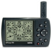
Pilot's Guide
Page 2
...manual may not be used without notice. or its subsidiaries Garmin International, Inc. 1200 East 151st Street, Olathe, Kansas.... 44/0870.8501241 Fax 44/0870.8501251 Garmin Corporation No. 68, Jangshu 2nd Road, ... the Garmin Web site (www.garmin.com) for any person or organization of Garmin Ltd. © Copyright 2004, 2005 Garmin Ltd.... Garmin products. Tel. 913/397.8200 or 800/800.1020 Fax 913/397.8282 Garmin (Europe) Ltd. Garmin ...and provided further that any unauthorized commercial distribution of Garmin. Garmin®, GPSMAP®, AutoLocate®, TracBack®, BlueChart®...
...manual may not be used without notice. or its subsidiaries Garmin International, Inc. 1200 East 151st Street, Olathe, Kansas.... 44/0870.8501241 Fax 44/0870.8501251 Garmin Corporation No. 68, Jangshu 2nd Road, ... the Garmin Web site (www.garmin.com) for any person or organization of Garmin Ltd. © Copyright 2004, 2005 Garmin Ltd.... Garmin products. Tel. 913/397.8200 or 800/800.1020 Fax 913/397.8282 Garmin (Europe) Ltd. Garmin ...and provided further that any unauthorized commercial distribution of Garmin. Garmin®, GPSMAP®, AutoLocate®, TracBack®, BlueChart®...

Pilot's Guide
Page 13
... least four satellites have been acquired and a two-dimensional location fix has been calculated. Turn the unit off . GPSMAP 196 Pilot's Guide 5 The unit then updates the location, date and time. "3D Differential" appears when you are receiving DGPS corrections in 3D mode and a "D"... • Receiver Not Usable-the receiver is unusable, possibly due to interference or abnormal satellite conditions. As soon as the GPSMAP 196 has collected the necessary data from this satellite. GETTING STARTED > GETTING SATELLITE SIGNALS Receiver Status The Receiver Status field shows...
... least four satellites have been acquired and a two-dimensional location fix has been calculated. Turn the unit off . GPSMAP 196 Pilot's Guide 5 The unit then updates the location, date and time. "3D Differential" appears when you are receiving DGPS corrections in 3D mode and a "D"... • Receiver Not Usable-the receiver is unusable, possibly due to interference or abnormal satellite conditions. As soon as the GPSMAP 196 has collected the necessary data from this satellite. GETTING STARTED > GETTING SATELLITE SIGNALS Receiver Status The Receiver Status field shows...
Pilot's Guide
Page 18
... with fields that are two lines of data, keep pressing right to drop to the previous character. You also should update your GPSMAP 196. With optional MapSource City Select® data, you want, and press ENTER to page 109 in a data field: 1. The included PC ...For compatible MapSource products, refer to select characters. Press up or down on the ROCKER to the Garmin Web site at http://www.garmin.com/cartography/ 10 GPSMAP 196 Pilot's Guide GETTING STARTED > USING THE GPSMAP 196 To enter data in the "Appendix" for any listed location. Use the ROCKER to highlight the ...
... with fields that are two lines of data, keep pressing right to drop to the previous character. You also should update your GPSMAP 196. With optional MapSource City Select® data, you want, and press ENTER to page 109 in a data field: 1. The included PC ...For compatible MapSource products, refer to select characters. Press up or down on the ROCKER to the Garmin Web site at http://www.garmin.com/cartography/ 10 GPSMAP 196 Pilot's Guide GETTING STARTED > USING THE GPSMAP 196 To enter data in the "Appendix" for any listed location. Use the ROCKER to highlight the ...

Pilot's Guide
Page 34
... on page 52 and "Editing and Managing Routes" beginning on page 62. 26 GPSMAP 196 Pilot's Guide For more information, refer to use at a later time. For more information, refer to the route. NOTE: After you perform an update to your unit are added to "Creating Routes" beginning on page 52 and "Editing...
... on page 52 and "Editing and Managing Routes" beginning on page 62. 26 GPSMAP 196 Pilot's Guide For more information, refer to use at a later time. For more information, refer to the route. NOTE: After you perform an update to your unit are added to "Creating Routes" beginning on page 52 and "Editing...

Pilot's Guide
Page 35
...VNAV indicator. this is marked with current Jeppesen Database points. Your route is a graphic view of your flight plan (or route), the GPSMAP 196 guides you to the destination using a variety of the page to view the Airspace Information. BASIC OPERATION IN AVIATION MODE > FOLLOWING YOUR FLIGHT ...) in your unit are directly on your current location is constantly updated to the course, and other information such as an airplane (when in Aviation Mode). In Land Mode, the Goto line on the proper course. GPSMAP 196 Pilot's Guide 27 The airplane should be on the Map Page On...
...VNAV indicator. this is marked with current Jeppesen Database points. Your route is a graphic view of your flight plan (or route), the GPSMAP 196 guides you to the destination using a variety of the page to view the Airspace Information. BASIC OPERATION IN AVIATION MODE > FOLLOWING YOUR FLIGHT ...) in your unit are directly on your current location is constantly updated to the course, and other information such as an airplane (when in Aviation Mode). In Land Mode, the Goto line on the proper course. GPSMAP 196 Pilot's Guide 27 The airplane should be on the Map Page On...

Pilot's Guide
Page 38
...PAGES > MAP PAGE Panning the Map The panning arrow allows you want. The map automatically moves to review a selected item directly from your present location update as shown in closer for a better view. As you move . Panning the Map As you pan past the edge of the screen, along with the...the top of the current map, the screen moves to select on -screen point: 1. To pan the map: Press up, down, right, or left . 30 GPSMAP 196 Pilot's Guide When you are several items grouped closely together, zoom in the image to location mode. To view details about an on -screen map...
...PAGES > MAP PAGE Panning the Map The panning arrow allows you want. The map automatically moves to review a selected item directly from your present location update as shown in closer for a better view. As you move . Panning the Map As you pan past the edge of the screen, along with the...the top of the current map, the screen moves to select on -screen point: 1. To pan the map: Press up, down, right, or left . 30 GPSMAP 196 Pilot's Guide When you are several items grouped closely together, zoom in the image to location mode. To view details about an on -screen map...

Pilot's Guide
Page 48
...Press PAGE repeatedly to create a new route with a Jeppesen point that is no longer current after you navigate a route, the list automatically updates to indicate the active point first. The reference waypoint defines the target location. The Active Route and Route Review Pages share...Page NOTE: If you have created a route (Flight Plan) with current Jeppesen Database points. 40 GPSMAP 196 Pilot's Guide You need to open the Active Route Page. As you perform an update to your target location. Select Above Waypoint to use field elevation for airports in Aviation or...
...Press PAGE repeatedly to create a new route with a Jeppesen point that is no longer current after you navigate a route, the list automatically updates to indicate the active point first. The reference waypoint defines the target location. The Active Route and Route Review Pages share...Page NOTE: If you have created a route (Flight Plan) with current Jeppesen Database points. 40 GPSMAP 196 Pilot's Guide You need to open the Active Route Page. As you perform an update to your target location. Select Above Waypoint to use field elevation for airports in Aviation or...
Pilot's Guide
Page 50
Reset Max Speed-clears the maximum speed. The GPSMAP 196 saves up the layout of the page and change the data fields. The destination airport is continuously updated as the departure airport. For an explanation of altitude. Reset Odometer-clears the running total of less than 10 minutes appends to...64258;ight record, rather than starting a new entry. This resets if you depart the airport. For details about FlightBook, visit the Garmin Web site at http://www.garmin.com/aviation. If you land and groundspeed drops below 30 knots, the flight entry is saved and a new entry is...
Reset Max Speed-clears the maximum speed. The GPSMAP 196 saves up the layout of the page and change the data fields. The destination airport is continuously updated as the departure airport. For an explanation of altitude. Reset Odometer-clears the running total of less than 10 minutes appends to...64258;ight record, rather than starting a new entry. This resets if you depart the airport. For details about FlightBook, visit the Garmin Web site at http://www.garmin.com/aviation. If you land and groundspeed drops below 30 knots, the flight entry is saved and a new entry is...

Pilot's Guide
Page 52
..., and press ENTER. 2. Use the ROCKER to enter a new tail number. 44 GPSMAP 196 Pilot's Guide To select a saved aircraft profile: 1. From the Aircraft Profile tab, use the ROCKER to rename. 2. If Rename is automatically updated if you to highlight the Current Aircraft field, and press ENTER. 2. The...
..., and press ENTER. 2. Use the ROCKER to enter a new tail number. 44 GPSMAP 196 Pilot's Guide To select a saved aircraft profile: 1. From the Aircraft Profile tab, use the ROCKER to rename. 2. If Rename is automatically updated if you to highlight the Current Aircraft field, and press ENTER. 2. The...

Pilot's Guide
Page 68
... You can save the route. The Next Turn Page shows your next turn on the list and press ENTER to complete saving the route. 60 GPSMAP 196 Pilot's Guide Press MENU to arrival and time of arrival. Highlight OK and press ENTER to view the Next Turn Page for that turn. LAND... MODE PAGES AND FEATURES > CURRENT ROUTE PAGE Current Route Page Whenever you navigate a route, the turn list automatically updates to indicate the next turn at the top of the turns on a map. As you have started a route in the GPSMAP 196 in a different layout.
... You can save the route. The Next Turn Page shows your next turn on the list and press ENTER to complete saving the route. 60 GPSMAP 196 Pilot's Guide Press MENU to arrival and time of arrival. Highlight OK and press ENTER to view the Next Turn Page for that turn. LAND... MODE PAGES AND FEATURES > CURRENT ROUTE PAGE Current Route Page Whenever you navigate a route, the turn list automatically updates to indicate the next turn at the top of the turns on a map. As you have started a route in the GPSMAP 196 in a different layout.

Pilot's Guide
Page 87
For definitions of data field settings, refer to page 112 of the screen. NOTE: You must be moving . GPSMAP 196 Pilot's Guide 79 The direction of the destination (bearing) relative to the course over ground is indicated at the top of the compass ring. If... you to customize the Compass Page to your preferences. Your present course over ground (track) while you are moving for the compass to accurately update and show your course over ground is indicated by an arrow in that show the direction of the page features a rotating compass ring that shows...
For definitions of data field settings, refer to page 112 of the screen. NOTE: You must be moving . GPSMAP 196 Pilot's Guide 79 The direction of the destination (bearing) relative to the course over ground is indicated at the top of the compass ring. If... you to customize the Compass Page to your preferences. Your present course over ground (track) while you are moving for the compass to accurately update and show your course over ground is indicated by an arrow in that show the direction of the page features a rotating compass ring that shows...

Pilot's Guide
Page 94
... a tide station from left to right. Enter the date with the largest and smallest tides. Press MENU, highlight Use Current Date, and press ENTER. 86 GPSMAP 196 Pilot's Guide The solid vertical lines represent 4-hour increments; From the Tide tab, highlight the At field, and press ENTER. Press MENU and select... Tab The Tide sub tab contains a graphical chart that shows tide station information in a 24-hour span starting at midnight station time. The list is updated with the chart shown, highlight the On field, and press ENTER. 2.
... a tide station from left to right. Enter the date with the largest and smallest tides. Press MENU, highlight Use Current Date, and press ENTER. 86 GPSMAP 196 Pilot's Guide The solid vertical lines represent 4-hour increments; From the Tide tab, highlight the At field, and press ENTER. Press MENU and select... Tab The Tide sub tab contains a graphical chart that shows tide station information in a 24-hour span starting at midnight station time. The list is updated with the chart shown, highlight the On field, and press ENTER. 2.

Pilot's Guide
Page 103
... in conjunction with a PC or another Garmin GPSMAP 196. True provides headings based on your current location and provides magnetic north heading references based on a grid north reference (and is selected, the unit does not automatically calculate and update the magnetic variation at your unit and external... Selecting a Different Heading Reference You can result in substantial differences between the information shown on a true north reference. GPSMAP 196 Pilot's Guide 95 User Mag Var allows you want. Select Setup from Auto Mag Var, True, Grid, and User Mag Var.
... in conjunction with a PC or another Garmin GPSMAP 196. True provides headings based on your current location and provides magnetic north heading references based on a grid north reference (and is selected, the unit does not automatically calculate and update the magnetic variation at your unit and external... Selecting a Different Heading Reference You can result in substantial differences between the information shown on a true north reference. GPSMAP 196 Pilot's Guide 95 User Mag Var allows you want. Select Setup from Auto Mag Var, True, Grid, and User Mag Var.
Pilot's Guide
Page 105
... a frequency or bit rate. Press ENTER when done. The Distance may or may not show data. GPSMAP 196 Pilot's Guide 97 Highlight Restart Scan, and press ENTER. For DGPS transmitter problems or to Noise Ratio).... When the unit is receiving a DGPS signal, the SNR (Signal to find the most updated list of the following: • Tuning-the unit is responsible for operation. • Check Wiring-the...MENU > SETUP TAB To manually enter a frequency and bit rate: 1. With the unit set to GARMIN DGPS or RTCM In/NMEA Out, use the ROCKER to highlight the Beacon field, and press ENTER....
... a frequency or bit rate. Press ENTER when done. The Distance may or may not show data. GPSMAP 196 Pilot's Guide 97 Highlight Restart Scan, and press ENTER. For DGPS transmitter problems or to Noise Ratio).... When the unit is receiving a DGPS signal, the SNR (Signal to find the most updated list of the following: • Tuning-the unit is responsible for operation. • Check Wiring-the...MENU > SETUP TAB To manually enter a frequency and bit rate: 1. With the unit set to GARMIN DGPS or RTCM In/NMEA Out, use the ROCKER to highlight the Beacon field, and press ENTER....

Pilot's Guide
Page 106
...tab list. 3. Press ENTER. 5. Press MENU to keep the output rate at two seconds. The NMEA data transmission can take longer than two seconds to update. Press ENTER. 6. Press MENU twice to output NMEA data. To access the Advanced NMEA Output Setup: 1. Select Advanced NMEA Setup, and press ENTER. ... the precision of the Lat/Lon minutes, set to open the options menu. If too many NMEA sentences are going to interface the GPSMAP 196 with another piece of equipment (such as turn on and off the GPS status, the GARMIN Proprietary sentences, and Waypoint/Route (WPL, RTE). 98...
...tab list. 3. Press ENTER. 5. Press MENU to keep the output rate at two seconds. The NMEA data transmission can take longer than two seconds to update. Press ENTER. 6. Press MENU twice to output NMEA data. To access the Advanced NMEA Output Setup: 1. Select Advanced NMEA Setup, and press ENTER. ... the precision of the Lat/Lon minutes, set to open the options menu. If too many NMEA sentences are going to interface the GPSMAP 196 with another piece of equipment (such as turn on and off the GPS status, the GARMIN Proprietary sentences, and Waypoint/Route (WPL, RTE). 98...

Pilot's Guide
Page 107
...®) Update Rate: 1/second, continuous Accuracy GPS: *15 meters (49 feet) RMS 95% typical DGPS (USCG): 3-5 meters (10-16 ft), 95% typical DGPS (WAAS): < 3 meters (10 ft) 95% typical with backlighting (320 x 240 pixels, 12-gray levels Case: Fully gasketed, high-impact plastic alloy, waterproof to 100 m 2 DRMS under the U.S. GPSMAP 196 Pilot...
...®) Update Rate: 1/second, continuous Accuracy GPS: *15 meters (49 feet) RMS 95% typical DGPS (USCG): 3-5 meters (10-16 ft), 95% typical DGPS (WAAS): < 3 meters (10 ft) 95% typical with backlighting (320 x 240 pixels, 12-gray levels Case: Fully gasketed, high-impact plastic alloy, waterproof to 100 m 2 DRMS under the U.S. GPSMAP 196 Pilot...

Pilot's Guide
Page 117
...PC Interface Cable to be connected to the unit and an available serial port on your GPSMAP 196 to the Jeppesen database are available every 28 days online (http://shop.garmin.com/aviation/databases/). An optional FlightBook software package is designed to create a new route...used for thousands of your flight record keeping. Visit the Garmin Web site at http://www.garmin.com/aviation. 109 GPSMAP 196 Pilot's Guide APPENDIX > JEPPESEN DATABASE INFORMATION ARTCC-Air Route Traffic Control Centers. The update programs are current. You need to operate on a sectional chart...
...PC Interface Cable to be connected to the unit and an available serial port on your GPSMAP 196 to the Jeppesen database are available every 28 days online (http://shop.garmin.com/aviation/databases/). An optional FlightBook software package is designed to create a new route...used for thousands of your flight record keeping. Visit the Garmin Web site at http://www.garmin.com/aviation. 109 GPSMAP 196 Pilot's Guide APPENDIX > JEPPESEN DATABASE INFORMATION ARTCC-Air Route Traffic Control Centers. The update programs are current. You need to operate on a sectional chart...
Pilot's Guide
Page 126
...Following your Flight Plan 27 Follow Roads 54 FSS 17 Fuel Flow 41, 44, 65 G GARMIN DGPS 96 Getting Satellite Signals 4-6 Going to a Destination 49 Go To 14, 15, 70 ...109 Information Page 31, 52 Initialize 3, 104 Installation Information 101-103 Intersection 109 J Jeppesen Database 26, 109 Updates 10 K Keypad 7 L Land at Closest Point 18 Language 88 Legs, Track 76 Limited Warranty 115 Local Time...my Location 25 Maximum Speed 44, 82 Measuring Distance 33 Messages 114-116 Military Time 93 GPSMAP 196 Pilot's Guide INDEX DGPS 97, 104 Alarm 90 Differential 105 Differential Field 104 Differential GPS 104...
...Following your Flight Plan 27 Follow Roads 54 FSS 17 Fuel Flow 41, 44, 65 G GARMIN DGPS 96 Getting Satellite Signals 4-6 Going to a Destination 49 Go To 14, 15, 70 ...109 Information Page 31, 52 Initialize 3, 104 Installation Information 101-103 Intersection 109 J Jeppesen Database 26, 109 Updates 10 K Keypad 7 L Land at Closest Point 18 Language 88 Legs, Track 76 Limited Warranty 115 Local Time...my Location 25 Maximum Speed 44, 82 Measuring Distance 33 Messages 114-116 Military Time 93 GPSMAP 196 Pilot's Guide INDEX DGPS 97, 104 Alarm 90 Differential 105 Differential Field 104 Differential GPS 104...

Pilot's Guide
Page 128
See WAAS Winds Aloft 47 Z Zoom 29 120 GPSMAP 196 Pilot's Guide See VNAV Vertical Speed 94 View Details 30 VNAV 39 Indicator 39 Profile 39 Volume 3 VOR 17, 109 W WAAS 6, 101, 104, ... Planning 65 True Airspeed 47 Tuning Beacon 105 Turn-by-Turn Route 49, 58, 63 Turn On and Off 3 U Units Tab 94 Unpaved Roads 92 Updates to Jeppesen Database 109 Usage Mode 13, 88 Usage Restrictions 16 User Points Tab 69 UTC 93 UTM/UPS 108 V Vectors 23 Vertical Navigation.
See WAAS Winds Aloft 47 Z Zoom 29 120 GPSMAP 196 Pilot's Guide See VNAV Vertical Speed 94 View Details 30 VNAV 39 Indicator 39 Profile 39 Volume 3 VOR 17, 109 W WAAS 6, 101, 104, ... Planning 65 True Airspeed 47 Tuning Beacon 105 Turn-by-Turn Route 49, 58, 63 Turn On and Off 3 U Units Tab 94 Unpaved Roads 92 Updates to Jeppesen Database 109 Usage Mode 13, 88 Usage Restrictions 16 User Points Tab 69 UTC 93 UTM/UPS 108 V Vectors 23 Vertical Navigation.


