Owner's Manual
Page 2
... rights reserved. January 2007 Part Number 190-00321-00 Rev. C Printed in the USA and other countries. or its subsidiaries. Garmin®, GPSMAP®, AutoLocate®, TracBack®, BlueChart®, and MapSource® are trademarks of Garmin Ltd. These trademarks may be reproduced, copied, transmitted, disseminated, downloaded or stored in the content without notice...
... rights reserved. January 2007 Part Number 190-00321-00 Rev. C Printed in the USA and other countries. or its subsidiaries. Garmin®, GPSMAP®, AutoLocate®, TracBack®, BlueChart®, and MapSource® are trademarks of Garmin Ltd. These trademarks may be reproduced, copied, transmitted, disseminated, downloaded or stored in the content without notice...
Owner's Manual
Page 7
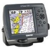
... adjusts fishfinder sensitivity according to 12 satellites for detailed electronic charting capability, the Garmin GPSMAP 172/172C is a powerful navigation device that can give you the information you need: ... reversible routes with up to 50 waypoints each • Uploadable maps using Garmin's MapSource PC products and BlueChart Data Cards • Coordinates: Lat/Lon, UTM/UPS, Loran TD,... Introduction Capabilities Superior Fishfinding Ability (when combined with backlighting • 12-channel parallel receiver tracks and uses up to depth • Multiple Zoom levels with a moving view...
... adjusts fishfinder sensitivity according to 12 satellites for detailed electronic charting capability, the Garmin GPSMAP 172/172C is a powerful navigation device that can give you the information you need: ... reversible routes with up to 50 waypoints each • Uploadable maps using Garmin's MapSource PC products and BlueChart Data Cards • Coordinates: Lat/Lon, UTM/UPS, Loran TD,... Introduction Capabilities Superior Fishfinding Ability (when combined with backlighting • 12-channel parallel receiver tracks and uses up to depth • Multiple Zoom levels with a moving view...
Owner's Manual
Page 8
Introduction Packing List vi Before installing and getting started with remote antenna. Standard Package: • GPSMAP 172/172C Unit • GA 29 Remote External Antenna and 30' cable* • Internal Antenna** • Single-Knob Tilt & Swivel Bracket •...includes the following items. If any parts are missing, please contact your Garmin dealer immediately. Optional Accessories: • US A/C, PC Adapter • EURO A/C, PC Adapter • UK A/C, PC Adapter • Cigarette Lighter Adapter • BlueChart Marine Data Cards, MapSource CDs, USB Data Card Programmer, and Data Cards ...
Introduction Packing List vi Before installing and getting started with remote antenna. Standard Package: • GPSMAP 172/172C Unit • GA 29 Remote External Antenna and 30' cable* • Internal Antenna** • Single-Knob Tilt & Swivel Bracket •...includes the following items. If any parts are missing, please contact your Garmin dealer immediately. Optional Accessories: • US A/C, PC Adapter • EURO A/C, PC Adapter • UK A/C, PC Adapter • Cigarette Lighter Adapter • BlueChart Marine Data Cards, MapSource CDs, USB Data Card Programmer, and Data Cards ...
Owner's Manual
Page 18
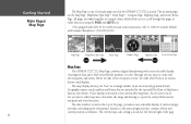
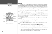
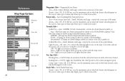
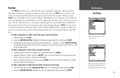
... to create and edit waypoints and routes. It is one of six main pages used in the GPSMAP 172/172C's system. Geographic names, roads, markers and buoys that are provided by the optional BlueChart or MapSource data are the Map Page, Map/Sonar Split Page*, Sonar Page* , Compass Page,...determine the range and bearing to "GSD 20 Sounder Module with Garmin Chartplotters" (190-00241-03)) Map Page Map/Sonar Split Page PAGE Sonar Page Compass Page Highway Page QUIT Active Route Page Map Page The GPSMAP 172/172C's Map Page combines digital chartplotting with a user-selectable display of...
... to create and edit waypoints and routes. It is one of six main pages used in the GPSMAP 172/172C's system. Geographic names, roads, markers and buoys that are provided by the optional BlueChart or MapSource data are the Map Page, Map/Sonar Split Page*, Sonar Page* , Compass Page,...determine the range and bearing to "GSD 20 Sounder Module with Garmin Chartplotters" (190-00241-03)) Map Page Map/Sonar Split Page PAGE Sonar Page Compass Page Highway Page QUIT Active Route Page Map Page The GPSMAP 172/172C's Map Page combines digital chartplotting with a user-selectable display of...

Owner's Manual
Page 23
... to review map items and create on-screen waypoints. You'll now have a clearer picture of the built-in database or the optional MapSource or BlueChart data in use the ARROW KEYPAD to move the cursor as close as possible to verify the cursor position.) 2. Do not hold the button down...
... to review map items and create on-screen waypoints. You'll now have a clearer picture of the built-in database or the optional MapSource or BlueChart data in use the ARROW KEYPAD to move the cursor as close as possible to verify the cursor position.) 2. Do not hold the button down...
Owner's Manual
Page 28
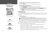
...User Land Waypoint Map Item Boat Icon Water Navaids Geographic Name Map Scale Map Page shown using optional MapSource data. 18 Map Page The GPSMAP 172/172C's Map Page provides a comprehensive display of the page. When the cursor is active, an additional data window appears below the data ...pans the cartography to the cursor or a selected waypoint or map item. The (ZOOM) IN and (ZOOM) OUT keys, combined with the optional BlueChart data or MapSource software, the map display shows your boat on the map display. • When sufficient map coverage is stationary, a fixed coordinate ...
...User Land Waypoint Map Item Boat Icon Water Navaids Geographic Name Map Scale Map Page shown using optional MapSource data. 18 Map Page The GPSMAP 172/172C's Map Page provides a comprehensive display of the page. When the cursor is active, an additional data window appears below the data ...pans the cartography to the cursor or a selected waypoint or map item. The (ZOOM) IN and (ZOOM) OUT keys, combined with the optional BlueChart data or MapSource software, the map display shows your boat on the map display. • When sufficient map coverage is stationary, a fixed coordinate ...

Owner's Manual
Page 29
... position to review a selected position directly from the map display. To select an on the map to display the information and additional options. When using BlueChart or MapSource data, additional information tabs appears. Use the ARROW KEYPAD to highlight the individual tabs to highlight it. Keep in an up additional details...
... position to review a selected position directly from the map display. To select an on the map to display the information and additional options. When using BlueChart or MapSource data, additional information tabs appears. Use the ARROW KEYPAD to highlight the individual tabs to highlight it. Keep in an up additional details...
Owner's Manual
Page 30
... map scale: 1. Use the ARROW KEYPAD to move the cursor to 1200 km). If the cursor is pressed. The GPSMAP 172/172C's system has a built-in . The GPSMAP 172/172C displays cartography as long as there is chart information available for the range you get a new window with more detailed coverage... again on a map item, you 've selected. Reference Map Page: Cursor and Zooming Creating New Map Waypoint Using Built-In Basemap Using BlueChart/MapSource Data Overzoom, no additional data 20 To eliminate the cursor and re-center your position on-screen: 1. The map scale is displayed ...
... map scale: 1. Use the ARROW KEYPAD to move the cursor to 1200 km). If the cursor is pressed. The GPSMAP 172/172C's system has a built-in . The GPSMAP 172/172C displays cartography as long as there is chart information available for the range you get a new window with more detailed coverage... again on a map item, you 've selected. Reference Map Page: Cursor and Zooming Creating New Map Waypoint Using Built-In Basemap Using BlueChart/MapSource Data Overzoom, no additional data 20 To eliminate the cursor and re-center your position on-screen: 1. The map scale is displayed ...
Owner's Manual
Page 33
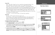
...do not wish to display the data on or off. North Up- fixes the top of the optional BlueChart/ MapSource data loaded on the screen. Track Up Below- for that map. The 'Data Card Maps'...AutoZoom - Highlight the 'Data Card Maps' option box and press ENTER. 2. On/Off: turns all optional BlueChart/MapSource data loaded on the data card on the Map Page. The map is selected and is the range ... scroll UP, DOWN, LEFT and RIGHT or press MENU and choose the desired scroll option. Color Mode - (172C) For Sun, For Dark (172) Water Mode, Land Mode Source Tab Basemap- On/Off: turns the built...
...do not wish to display the data on or off. North Up- fixes the top of the optional BlueChart/ MapSource data loaded on the screen. Track Up Below- for that map. The 'Data Card Maps'...AutoZoom - Highlight the 'Data Card Maps' option box and press ENTER. 2. On/Off: turns all optional BlueChart/MapSource data loaded on the data card on the Map Page. The map is selected and is the range ... scroll UP, DOWN, LEFT and RIGHT or press MENU and choose the desired scroll option. Color Mode - (172C) For Sun, For Dark (172) Water Mode, Land Mode Source Tab Basemap- On/Off: turns the built...
Owner's Manual
Page 34
...Snd.), Small, Medium, and Large: controls the screen size of the name. Non- BlueChart maps are drawn for all lights that have them with the map cursor. All maps are drawn using traditional Garmin symbols. Light Sectors- Off, Auto, On: controls the drawing light sectors on the screen...appear on the map. Some types of data only shows up to the current navigation point. Navaids Tab- Symbol Set- BlueChart maps are drawn using symbols similar to NOAA/NIMA. GARMIN - NOAA - All maps are drawn using a symbol set . International - Small, Medium, and Large: controls the ...
...Snd.), Small, Medium, and Large: controls the screen size of the name. Non- BlueChart maps are drawn for all lights that have them with the map cursor. All maps are drawn using traditional Garmin symbols. Light Sectors- Off, Auto, On: controls the drawing light sectors on the screen...appear on the map. Some types of data only shows up to the current navigation point. Navaids Tab- Symbol Set- BlueChart maps are drawn using symbols similar to NOAA/NIMA. GARMIN - NOAA - All maps are drawn using a symbol set . International - Small, Medium, and Large: controls the ...

Owner's Manual
Page 35
... following menu options by pressing MENU: • Defaults- Map Outlines- restores settings back to final waypoint • DIST TO NEXT - Distance to factory settings for BlueChart/MapSource data "On" and "Off". On/Off: toggles the coverage boxes for the tab highlighted. • All Map Defaults- Accuracy Circle- On/Off: toggles the...
... following menu options by pressing MENU: • Defaults- Map Outlines- restores settings back to final waypoint • DIST TO NEXT - Distance to factory settings for BlueChart/MapSource data "On" and "Off". On/Off: toggles the coverage boxes for the tab highlighted. • All Map Defaults- Accuracy Circle- On/Off: toggles the...

Owner's Manual
Page 44
..., highlight 'OK' (Waypoint Review Page) or 'Next' (Waypoint Edit Page) and press ENTER to highlight the desired waypoint on a MapSource or BlueChart feature, the Waypoint Review page includes additional information tabs about the other map features. Use the ARROW KEYPAD to display the Waypoint Edit page. Use...KEYPAD to select the desired symbol and press ENTER when done. If the waypoint is located on a map feature, or on a MapSource or BlueChart feature, the Waypoint Edit page does NOT display the details of the waypoint name and press ENTER. 2. To access the Waypoint Edit page: 1....
..., highlight 'OK' (Waypoint Review Page) or 'Next' (Waypoint Edit Page) and press ENTER to highlight the desired waypoint on a MapSource or BlueChart feature, the Waypoint Review page includes additional information tabs about the other map features. Use the ARROW KEYPAD to display the Waypoint Edit page. Use...KEYPAD to select the desired symbol and press ENTER when done. If the waypoint is located on a map feature, or on a MapSource or BlueChart feature, the Waypoint Edit page does NOT display the details of the waypoint name and press ENTER. 2. To access the Waypoint Edit page: 1....
Owner's Manual
Page 61
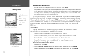
... search the unit for user waypoints, map items, and any page, press FIND. 2. The default items are displayed depending on a data card. From any optional BlueChart or MapSource information loaded on the optional BlueChart or MapSource data card inserted into the unit. For Waypoints and Cities, you may search using... BlueChart or MapSource data, your position or the map pointer must be within the map outline area to search for items from your current location: 1. To ...
... search the unit for user waypoints, map items, and any page, press FIND. 2. The default items are displayed depending on a data card. From any optional BlueChart or MapSource information loaded on the optional BlueChart or MapSource data card inserted into the unit. For Waypoints and Cities, you may search using... BlueChart or MapSource data, your position or the map pointer must be within the map outline area to search for items from your current location: 1. To ...
Owner's Manual
Page 62
... allows you to search. • Nearest To Next- Available Find options are available for viewing the item on the map, viewing notes on a MapSource or BlueChart map, viewing a tide chart, viewing a list of maps on the type of item, additional options are : • Nearest To Boat- allows you see "From Anchoring...
... allows you to search. • Nearest To Next- Available Find options are available for viewing the item on the map, viewing notes on a MapSource or BlueChart map, viewing a tide chart, viewing a list of maps on the type of item, additional options are : • Nearest To Boat- allows you see "From Anchoring...
Owner's Manual
Page 103
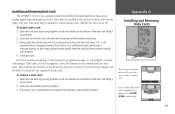
...noting the card details when the card has been properly installed and accepted. 4. If the unit is still not recognized, contact the Garmin or your Garmin dealer for assistance. Data cards are installed in not necessary to display digital charts and maps on , a confirmation tone sounds when the.... It in the card slot located at any time, whether the unit is on -screen. Installing and Removing Data Cards The GPSMAP 172/172C uses optional Garmin marine BlueChart and MapSource data cards to force the card and about 1/2" is still exposed when it is properly inserted. Data cards are not...
...noting the card details when the card has been properly installed and accepted. 4. If the unit is still not recognized, contact the Garmin or your Garmin dealer for assistance. Data cards are installed in not necessary to display digital charts and maps on , a confirmation tone sounds when the.... It in the card slot located at any time, whether the unit is on -screen. Installing and Removing Data Cards The GPSMAP 172/172C uses optional Garmin marine BlueChart and MapSource data cards to force the card and about 1/2" is still exposed when it is properly inserted. Data cards are not...
Owner's Manual
Page 104
... Route 33 Arrival Alarm 76 ARROW KEYPAD 1 AutoLocate 57 AutoZoom 23 B Backlight 1, 6 Basemap 23 Battery Alarm 76 Bearing Line 24 Bearing Pointer 27 Beeper 69 BlueChart 23, 24, 93 94 C Capabilities v Card Tab 68 Celes Tab 60 Change Numbers 16, 25, 29 Cleaning 87 Clock Alarm 76 Color Mode 23 Communications...
... Route 33 Arrival Alarm 76 ARROW KEYPAD 1 AutoLocate 57 AutoZoom 23 B Backlight 1, 6 Basemap 23 Battery Alarm 76 Bearing Line 24 Bearing Pointer 27 Beeper 69 BlueChart 23, 24, 93 94 C Capabilities v Card Tab 68 Celes Tab 60 Change Numbers 16, 25, 29 Cleaning 87 Clock Alarm 76 Color Mode 23 Communications...


