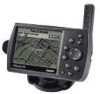
Garmin GPSMAP 176 Support Question
Garmin GPSMAP 176 Support Question
Find answers below for this question about Garmin GPSMAP 176 - Marine GPS Receiver.Need a Garmin GPSMAP 176 manual? We have 2 online manuals for this item!
Question posted by goodtoknow on August 21st, 2012
I Need Bluechart Chip Or Chips For West Coast Of Florida To Ny. Canyou Help
I need bluechart chip or chips for west coast of florida to NY. canyou help?
My need is immediate!
Current Answers
Related Garmin GPSMAP 176 Manual Pages
Owner's Manual - Page 4
... guide, contact Garmin Product Support in the unit's memory without the need for anti-reflective coatings and a clean, lint-free cloth. CLEANERS CONTAINING AMMONIA HARM THE ANTI-REFLECTIVE COATING.
Prolonged submersion can withstand immersion in Water The GPSMAP 176/176C is very sensitive to MapSource). It is very important to clean...
Owner's Manual - Page 11
... antenna is automatic and should only take a little longer to display the GPS Information page.
2.
The GPS receiver only needs to satellites while updating the Almanac. Following the screen prompts, press ENTER to become operational using this method. BASIC OPERATION
Initializing the GPS Receiver
The GPSMAP 176/176C must be initialized before it can become "cold." The orbital...
Owner's Manual - Page 14

...To view additional details about the chart
or Map List to view the list of BlueChart or MapSource data, an Information page appears. Use the ROCKER to highlight OK or ... Using Waypoints" on your data card through the Data Card Information screen.
10
GPSMAP 176/176C Owner's Manual Information tabs for BlueChart data (Chart tab shown).
Refer to create a new waypoint directly from the map...
Owner's Manual - Page 15

... data, cartography is available for the range you select. The zoom range is available through optional BlueChart or MapSource data. Using BlueChart/MapSource Data
Overzoom, no additional data
GPSMAP 176/176C Owner's Manual
11
The GPSMAP 176/176C displays cartography as long as chart information is displayed using the data with the current range displayed at...
Owner's Manual - Page 21

..., location coordinates, or depth for the selected waypoint. Press ENTER/MARK to the Map page.
GPSMAP 176/176C Owner's Manual
BASIC OPERATION > CREATING AND USING WAYPOINTS
Select OK to exit/save them. Reviewing... highlight the desired waypoint on a map feature, or MapSource or BlueChart feature, the Waypoint Edit page does NOT display the details of the waypoint name and press ENTER/MARK.
...
Owner's Manual - Page 22

... use the Waypoint Review and Waypoint Edit pages to the Right on the map. Waypoint Review page for a waypoint located on the map. (BlueChart map data shown.)
18
GPSMAP 176/176C Owner's Manual
See "Projecting Waypoints" page 15. Press ENTER/MARK when finished.
Highlight the desired field and press ENTER/MARK...
Owner's Manual - Page 30

This eliminates the need to store waypoints along those points. Highlight OK and press ENTER. You must first save an active track log.
26
GPSMAP 176/176C Owner's Manual
Press MENU twice to the...TracBack routes are created by reducing your path using the track log automatically stored in the receiver's memory. Highlight Save and press ENTER to retrace your track log to a route of...
Owner's Manual - Page 43

....
• Reverse Route-see page 38 for instructions.
• Plan Route-see page 38 for information from the BlueChart or MapSource data. Active Route Page Whenever you have activated a route in the GPSMAP 176/176C, the Active Route page shows each point from your current location or from another location on the optional...
Owner's Manual - Page 44

..., viewing notes on a MapSource or BlueChart map, viewing a tide chart, viewing the list of maps on the map and press ENTER.
Highlight Nearest to the new map location. Select a reference location on your data card, and viewing the next item in the search results list.
40
GPSMAP 176/176C Owner's Manual
The Find...
Owner's Manual - Page 45

... or MapSource software, the map display shows your location on the map display.
The GPSMAP 176/176C always powers up in the position mode, with the last known location centered on a digital chart, complete with optional BlueChart Marine data. For more information on -screen pointer lets you pan and scroll to a position, and perform...
Owner's Manual - Page 47

...desired option, None, Small (1 Column), Small (2 Columns), 2 Columns With Compass, or Large (1 Column), and press ENTER.
43
GPSMAP 176/176C Owner's Manual
MAIN PAGES > MAP PAGE
Small (1 Column)
Large (1 Column) Small (2 Columns)
2 Columns With Compass
Page...
Bearing Map Pointer Coordinates
Full screen map shown (with BlueChart data)
To measure the Bearing/Distance between two points:
1.
Owner's Manual - Page 66

...selection and press
ENTER until the information for that location is displayed on using the Find feature.
62
GPSMAP 176/176C Owner's Manual When using appears in the Date/Time/Position field.
To use current ... TAB
To choose another location outside of your time zone, you need to set the Time Zone for that location is displayed on the date and location of your current time...
Owner's Manual - Page 67

... Up: fixes the top of the map display to Auto. If using optional BlueChart data, Water Mode is always "up" and turns the navigation leg line vertical on the screen.
Some types of navigation is recommended. GPSMAP 176/176C Owner's Manual
63 Course Up: fixes the map so the direction of...
Owner's Manual - Page 69

... Set-controls which symbol set to use:
• Auto: BlueChart maps are drawn using the IALA symbol set .
• ...BlueChart maps are drawn using traditional Garmin symbols.
• Garmin: maps are drawn using traditional Garmin symbols.
• NOAA: maps are drawn using symbols similar to the NOAA/NIMA standard. Light Sectors-Off, Auto, On: controls the display of the name.
GPSMAP 176...
Owner's Manual - Page 72

... coverage boxes for BlueChart/MapSource data On and Off. Your position is loaded. Setup Map Menu Options From the Map Setup page (Map tab of the unit based on the screen.
• Accuracy Circle-On/Off: toggles the circle On and Off. Data Card Information Screen Options
68
GPSMAP 176/176C Owner's Manual...
Owner's Manual - Page 80

...with the DGPS receiver. Press ENTER when done. The SNR range is receiving DGPS signal and ready for their Web site at http://www.navcen.uscg.mil/.
76
GPSMAP 176/176C Owner's Manual..., or visit their accuracy and maintenance. Coast Guard (or similar government agency in other countries), which is responsible for operation.
• Check Wiring-unit is receiving a DGPS signal, the "SNR" (...
Owner's Manual - Page 81
... NMEA data can also change the precision of the Lat/Lon minutes. With the GPSMAP 176/176C turned on /off the GPS status (GSA, GSV), Waypoint/Route (WPL, RTE), and the Garmin Proprietary sentences...the unit needs to be set up the Advanced NMEA page:
1. To turn on , press MENU twice to select the SetupInterface tab.
2. If too many NMEA sentences are going to interface the GPSMAP 176/176C with ...
Owner's Manual - Page 85

.... They are using the GPSMAP 176/176C outside of the GPS signal. The Wide Area Augmentation System (WAAS) is Differential GPS (DGPS)?
NOTE: If you are operational in September of 2003 confirmed an accuracy of the continental U.S. GPSMAP 176/176C Owner's Manual
81
It is WAAS? Using DGPS requires additional equipment. Coast Guard's Web site...
Owner's Manual - Page 91

... name already exists.
Track Memory Full-No more track points, you need to "Stop When Full." APPENDIX > MESSAGES
Track Truncated-A complete uploaded track will not fit in memory. Waypoint Memory Full-The unit has stored the maximum number of waypoints. GPSMAP 176/176C Owner's Manual
87 To record more track data can be...
Quick Start Guide - Page 13
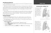
...to gather and save the waypoint (see pages 9-10). Initializing the GPS Receiver
Before the GPSMAP 176 can be used for navigation the receiver has to be headed toward your destination. The Track Log is not...will only take a little longer for the unit to search for all satellites. Since it needs to become operational using this waypoint 'HOME', assign the 'Residence' symbol and save the ...
Similar Questions

Do All 4 Wires Need To Be Connected?
do all 4 wires need connected. Not interested in sharing data.
do all 4 wires need connected. Not interested in sharing data.
(Posted by Zekerondog1 6 years ago)


No Satelites?
My Garmin 176 no longer receives Satelites. Is there any way to send the unit in for repair anywhere...
My Garmin 176 no longer receives Satelites. Is there any way to send the unit in for repair anywhere...
(Posted by captcamo 7 years ago)


Fish Finder
I have sent this unit back and they sent me a new one? but still cant get ubit to locate fish, it is...
I have sent this unit back and they sent me a new one? but still cant get ubit to locate fish, it is...
(Posted by glipsky 13 years ago)