Garmin GPSMAP 7408xsv Support and Manuals
Get Help and Manuals for this Garmin item

View All Support Options Below
Free Garmin GPSMAP 7408xsv manuals!
Problems with Garmin GPSMAP 7408xsv?
Ask a Question
Free Garmin GPSMAP 7408xsv manuals!
Problems with Garmin GPSMAP 7408xsv?
Ask a Question
Garmin GPSMAP 7408xsv Videos

??????-??????????? Garmin Gpsmap 7408xsv
Duration: 2:50
Total Views: 545
Duration: 2:50
Total Views: 545
Popular Garmin GPSMAP 7408xsv Manual Pages
Owner s Manual - Page 3
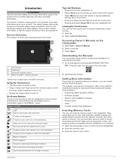
...Buttons 1 Tips and Shortcuts 1 Locking the Touchscreen 1 Accessing Owner's Manuals on the Chartplotter 1 Downloading the Manuals 1 Getting More Information 1 Inserting Memory Cards 1 Software Update 2 Loading the New Software on a Memory Card 2 Updating the Device Software 2 GPS Satellite Signals 2 Selecting the GPS Source 2
Customizing the Chartplotter 2 Home Screen 2
Adding an Item...
Owner s Manual - Page 7
...models have any questions about your product.
TIP: To quickly open this web page, scan this code:
2 Download the manual. The website, www.garmin.com/support, offers many different troubleshooting...Garmin Product Support. The support pages will provide answers to frequently asked questions (FAQs) • Software updates • Owner's and installation manuals • Service...
settings about...
Owner s Manual - Page 8
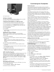
...garmin.com/support/software/marine.html. 3 Select Download next to GPSMAP Series with the memory card, and select
Next > Finish. The Settings...update instructions to appear, the device must collect satellite data and establish the current location. The item is selected from the home screen, one GPS source. 1 Select Settings > System > GPS > Source. 2 Select the source for the Settings...installed ...
Owner s Manual - Page 12

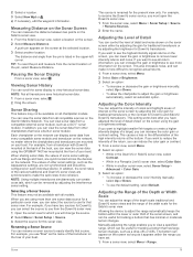
...at that the depth or GPS position data is available with premium charts, in some areas. Display Offset: Sets differences in the chart setup. Tide direction and tide...specific location on the Satellite Photos setting in contour depths and depth labels on the memory card. Garmin Quickdraw Contours Settings From the chart, select Menu > Quickdraw Contours > Settings. You must have a supported...
Owner s Manual - Page 25
... back of interest on the Garmin Marine Network. Allowing the device...GPSMAP 7407xsv mounted at the front of the pin, select Measure Distance. This setting... Appearance settings, are using the gain or brightness settings. For example, from all chartplotter models. Selecting...Sonar Setup >
Advanced > Color Gain. 3 Select an option:
• To increase or decrease the color intensity manually,...
Owner s Manual - Page 28
... surface that is
focused. Smoothing can reduce noise.
Sonar Appearance Settings From a sonar view, select Menu > Sonar Setup > Appearance. Shallow Water: Sets an alarm to sound when the depth is used to select the specific channel that shows instantaneously the range to detect the installation angle of the Panoptix transducer automatically. Transmit: Stops the transducer...
Owner s Manual - Page 35
...replaces the first call in increasingly larger circles outward from your radio, the chartplotter shows the man-overboard screen and prompts you have a Garmin NMEA 2000 VHF radio connected to initiate a man-overboard distress call . 3 Select Review...set... GPS ...Service Identity (MMSI) of the
vessel. 3 Enter the name of the DSC distress call . This feature is connected to a Garmin... manual.
...
Owner s Manual - Page 43
... supported video...service was updated.
Naming Video Presets on the Fishing Chart From the Fishing chart, select Menu > Chart Setup > Weather. TIP: You can show weather radar, height of available features. Camera Settings Some cameras provide additional options to a Garmin Marine Network chartplotter damages the Garmin chartplotter and may need to update the camera software to www.garmin...
Owner s Manual - Page 44
...models and chartplotter models. 1 From the video screen, select Menu > Video Setup. 2 Select an option:
• To show the video using gestures directly on all camera models and chartplotter models... to update the camera software to the settings for ...Setup > Set Input. 4 Select the video input. If your camera user manual for all possible video inputs or video encoder channels that support...
Owner s Manual - Page 47

... for specific weather events.
Waypoint IDs: Sets the device to sound when the battery reaches a specified low voltage. You can connect a chartplotter to a Garmin Marine Network to receive data from and share data with other Garmin devices. 1 Select Settings > Communications > NMEA 0183 Setup >
Port Types. 2 Select an input or output port. 3 Select a format:
• To support the...
Owner s Manual - Page 51
... screen you have manually entered a waypoint using an external GPS antenna, make sure the device is receiving is found near the map key.
2 On the chartplotter, select Settings > Preferences > Units. 3 Select the correct map datum and position format settings. 4 Create the waypoint again. Position format is installed. If not, update
the device software (Software Update, page 2). •...
Owner s Manual - Page 53
... detailed maps 44 installing 1 slot 1...overboard 10, 28, 29 manual viewer 1 maps. See ...6 antenna, GPS 2 arrival alarm...settings 43
stations 3 favorites 2 Fish Eye 3D
sonar cone 9 suspended targets 9 tracks 9 fishing chart 4, 37 boundary line 8 setup 8 fuel capacity 31, 42 fuel gauges 30, 31 status alarm 31, 41 synchronizing with actual fuel 31
G Garmin Marine Network 15, 41 Garmin product support...
Camera Integration Guide - Page 3
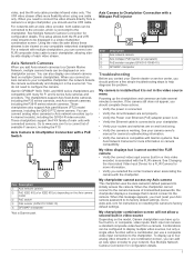
... (GPN 010-10580-10) GPSMAP chartplotter
Troubleshooting
Before you contact your Garmin dealer or service center, you connect an Axis camera to its factory default settings. See your Axis camera password to your routers and switches are compatible with connected sensors.
Garmin GPSMAP 7400, 7600, and 8000 series chartplotters are on the Axis camera
Á
model PoE switch*
Â...
Camera Integration Guide - Page 4

... a registered trademark of Axis AB.
Other trademarks and trade names are trademarks of Garmin Ltd. or its subsidiaries, registered in a combination screen display For cameras connected to...© 2015 Garmin Ltd. or its subsidiaries
www.garmin.com/support FLIR® is a registered trademark of FLIR Systems, Inc. Garmin®, the Garmin logo, GMS™, and GPSMAP® are those...
Installation Instructions - Page 4

...is needed to
limit the current from the chartplotter to 100 mA. • To manually toggle visual and audible alerts, you are unfamiliar with a lamp, a horn, ...8226; The installation instructions provided with all devices on the boat connected by a Garmin Marine Network cable. NMEA 0183 Connection Diagram
+
-
Item
Description NMEA 2000 compatible Garmin device GPS antenna Ignition or...
Garmin GPSMAP 7408xsv Reviews
We have not received any reviews for Garmin yet.