
Owners Manual
Page 3
... Tracking Settings 15 Turning Off Activity Tracking 15 Workouts 15 Following a Workout From the Web 15 Starting a Workout 15 About the Training Calendar 15 Using Garmin Connect Training Plans 15 Interval Workouts 15 Creating an Interval Workout 15 Table of Contents Introduction 1 Device Overview 1 Viewing the Controls Menu 1 Viewing Widgets 1 Charging the Device 1 Updating the Aviation Database 1 Pairing Your Smartphone with Your Device 1 Product Updates 2 Setting Up Garmin Express 2 Flying 2 Setting the Altitude Alert 2 Setting the Barometric Pressure Manually 2 Viewing...
... Tracking Settings 15 Turning Off Activity Tracking 15 Workouts 15 Following a Workout From the Web 15 Starting a Workout 15 About the Training Calendar 15 Using Garmin Connect Training Plans 15 Interval Workouts 15 Creating an Interval Workout 15 Table of Contents Introduction 1 Device Overview 1 Viewing the Controls Menu 1 Viewing Widgets 1 Charging the Device 1 Updating the Aviation Database 1 Pairing Your Smartphone with Your Device 1 Product Updates 2 Setting Up Garmin Express 2 Flying 2 Setting the Altitude Alert 2 Setting the Barometric Pressure Manually 2 Viewing...

Owners Manual
Page 4
...27 Calibrating the Compass Manually 27 Setting the North Reference 27 Altimeter Settings 27 Calibrating the Barometric Altimeter 27 Barometer Settings 27 Elevation Settings 28 Map Settings 28 Marine Map Settings 28 Showing and Hiding Map Data 28 GroupTrack Settings 28 Navigation Settings 28 Customizing Map Features 28 Setting Up a Heading Bug 28 Setting Navigation Alerts 28 System Settings 28 Time Settings 29 Changing the Backlight Settings 29 Customizing the Controls Menu 29 Customizing the Hot Keys 29 Changing the Units of Measure 29 Viewing Device Information 29 Viewing...
...27 Calibrating the Compass Manually 27 Setting the North Reference 27 Altimeter Settings 27 Calibrating the Barometric Altimeter 27 Barometer Settings 27 Elevation Settings 28 Map Settings 28 Marine Map Settings 28 Showing and Hiding Map Data 28 GroupTrack Settings 28 Navigation Settings 28 Customizing Map Features 28 Setting Up a Heading Bug 28 Setting Navigation Alerts 28 System Settings 28 Time Settings 29 Changing the Backlight Settings 29 Customizing the Controls Menu 29 Customizing the Hot Keys 29 Changing the Units of Measure 29 Viewing Device Information 29 Viewing...
Owners Manual
Page 5
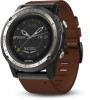
... Pod Calibration 30 Calibrating Your Foot Pod Manually 30 Setting Foot Pod Speed and Distance 30 tempe 30 Device Information 30 D2 Charlie Specifications 30 Battery Information 30 Data Management 31 Disconnecting the USB Cable 31 Deleting Files 31 Device Maintenance 31 Device Care 31 Cleaning the Device 31 Cleaning the Leather Bands 31 Changing the QuickFit™ Bands 31 Metal Watch Band Adjustment 31 Troubleshooting 31 My device is in the wrong language 31 Is...
... Pod Calibration 30 Calibrating Your Foot Pod Manually 30 Setting Foot Pod Speed and Distance 30 tempe 30 Device Information 30 D2 Charlie Specifications 30 Battery Information 30 Data Management 31 Disconnecting the USB Cable 31 Deleting Files 31 Device Maintenance 31 Device Care 31 Cleaning the Device 31 Cleaning the Leather Bands 31 Changing the QuickFit™ Bands 31 Metal Watch Band Adjustment 31 Troubleshooting 31 My device is in the wrong language 31 Is...

Owners Manual
Page 7
... data. 1 Connect your device to a computer using the included USB cable. 2 Go to www.flyGarmin.com. 3 Log in to your unit ID on do not disturb mode, locking the keys, and turning the device off . À LIGHT Hold to turn on the device. The first time you turn on the device, it must create a Garmin® account and add your device. Select to the previous screen. Updating the Aviation Database Before you are pairing a device with the Garmin Connect...
... data. 1 Connect your device to a computer using the included USB cable. 2 Go to www.flyGarmin.com. 3 Log in to your unit ID on do not disturb mode, locking the keys, and turning the device off . À LIGHT Hold to turn on the device. The first time you turn on the device, it must create a Garmin® account and add your device. Select to the previous screen. Updating the Aviation Database Before you are pairing a device with the Garmin Connect...

Owners Manual
Page 8
... to these services for your detected climb rate exceeds this device as a primary means of the square, you set the current barometric pressure manually. You can set in magenta. The device downloads a square of radar data for Garmin devices: • Software updates • Map updates • Data uploads to Garmin Connect • Product registration Setting Up Garmin Express 1 Connect the device to select an altitude. NOTE: If you are near the border of navigation. The default auto fly...
... to these services for your detected climb rate exceeds this device as a primary means of the square, you set the current barometric pressure manually. You can set in magenta. The device downloads a square of radar data for Garmin devices: • Software updates • Map updates • Data uploads to Garmin Connect • Product registration Setting Up Garmin Express 1 Connect the device to select an altitude. NOTE: If you are near the border of navigation. The default auto fly...

Owners Manual
Page 9
... compatibility information. 1 Pair your smartphone with your D2 device (Pairing Your Smartphone with the selected location, select NEXRAD (Viewing NEXRAD Weather Radar, page 2). • To show the waypoint on the map, select Show Map. • To view general information, such as the distance and bearing from a list of the flight plan. 5 Select . 6 Select Add Location. 7 Select a category. 8 Select the first point on your ground speed exceeds 30 kn. 1 Hold UP. 2 Select Settings > Activities & Apps > FLY. 3 Select the activity settings. 4 Select Flight Timer > Manual. The...
... compatibility information. 1 Pair your smartphone with your D2 device (Pairing Your Smartphone with the selected location, select NEXRAD (Viewing NEXRAD Weather Radar, page 2). • To show the waypoint on the map, select Show Map. • To view general information, such as the distance and bearing from a list of the flight plan. 5 Select . 6 Select Add Location. 7 Select a category. 8 Select the first point on your ground speed exceeds 30 kn. 1 Hold UP. 2 Select Settings > Activities & Apps > FLY. 3 Select the activity settings. 4 Select Flight Timer > Manual. The...

Owners Manual
Page 10
... type. 4 Select a name or enter a custom name. Editing a Flight Plan 1 Select > FLY. 2 Hold UP. 3 Select Navigation > Flight Planning > Saved Plans. 4 Select a flight plan. 5 Select Edit. 6 Select an option: • To view detailed information about activity tracking and fitness metric accuracy, go to your ANT+® sensors. 5 If the activity requires GPS, go outside, and wait while the device locates satellites. 6 Select to Start > Route. NOTE: This feature is turned off , speed and distance are calculated using a stationary bike. Indoor Activities The D2 device...
... type. 4 Select a name or enter a custom name. Editing a Flight Plan 1 Select > FLY. 2 Hold UP. 3 Select Navigation > Flight Planning > Saved Plans. 4 Select a flight plan. 5 Select Edit. 6 Select an option: • To view detailed information about activity tracking and fitness metric accuracy, go to your ANT+® sensors. 5 If the activity requires GPS, go outside, and wait while the device locates satellites. 6 Select to Start > Route. NOTE: This feature is turned off , speed and distance are calculated using a stationary bike. Indoor Activities The D2 device...
Owners Manual
Page 16
... max. Getting Your VO2 Max. If your heart rate variability while standing still for earlier training. HRV stress test: The HRV (heart rate variability) stress test requires a Garmin chest heart rate monitor. The device records your D2 Charlie device was 10 Heart Rate Features Functional threshold power (FTP): The device uses your user profile information from the initial setup to maintain your fitness level. Lactate threshold: Lactate threshold requires a chest heart rate monitor. estimate. 1 Hold UP. 2 Select Settings > Physiological Metrics > Performance Notifications. 3 Select...
... max. Getting Your VO2 Max. If your heart rate variability while standing still for earlier training. HRV stress test: The HRV (heart rate variability) stress test requires a Garmin chest heart rate monitor. The device records your D2 Charlie device was 10 Heart Rate Features Functional threshold power (FTP): The device uses your user profile information from the initial setup to maintain your fitness level. Lactate threshold: Lactate threshold requires a chest heart rate monitor. estimate. 1 Hold UP. 2 Select Settings > Physiological Metrics > Performance Notifications. 3 Select...
Owners Manual
Page 21
....com. 3 Create and save a new workout. 4 Select Send to start a workout, you set the number of repetitions, select Repeat. • To add an open intervals for track workouts and when you begin a workout, the device displays each workout step and for varied distances, times, and calories. After you are turned on the digital watch face, select . 2 Select an activity. 3 Hold UP. 4 Select Training > My Workouts. Interval Workouts You can use a training plan from Garmin Connect, and transfer them...
....com. 3 Create and save a new workout. 4 Select Send to start a workout, you set the number of repetitions, select Repeat. • To add an open intervals for track workouts and when you begin a workout, the device displays each workout step and for varied distances, times, and calories. After you are turned on the digital watch face, select . 2 Select an activity. 3 Hold UP. 4 Select Training > My Workouts. Interval Workouts You can use a training plan from Garmin Connect, and transfer them...
Owners Manual
Page 25
... device collects elevation and pressure data continuously, even in the crosshairs. 4 Hold to select the point indicated by -turn directions help you navigate to the starting point of interest and waypoints. This feature is marked with the selected location, select Show NEXRAD (Viewing NEXRAD Weather Radar, page 2). • To start navigating to the location, select Go. • To save the location, select Save. • To view information about the location, select Review. The arrow points toward your approximate elevation based on pressure changes. Map Your D2 Charlie...
... device collects elevation and pressure data continuously, even in the crosshairs. 4 Hold to select the point indicated by -turn directions help you navigate to the starting point of interest and waypoints. This feature is marked with the selected location, select Show NEXRAD (Viewing NEXRAD Weather Radar, page 2). • To start navigating to the location, select Go. • To save the location, select Save. • To view information about the location, select Review. The arrow points toward your approximate elevation based on pressure changes. Map Your D2 Charlie...

Owners Manual
Page 26
... on the connected smartphone. Elevation reflects changes in ambient pressure and GPS position. History History includes time, distance, calories, average pace or speed, lap data, and optional ANT+ sensor information. Viewing Your Time in real time. Activity uploads to Garmin Connect: Automatically sends your live data on screen and in Each Heart Rate Zone Before you can adjust the altimeter settings by holding UP, selecting Settings > Activities & Apps > FLY, selecting the activity settings, and selecting Altimeter. Elevation remains constant. Multisport History Your device stores...
... on the connected smartphone. Elevation reflects changes in ambient pressure and GPS position. History History includes time, distance, calories, average pace or speed, lap data, and optional ANT+ sensor information. Viewing Your Time in real time. Activity uploads to Garmin Connect: Automatically sends your live data on screen and in Each Heart Rate Zone Before you can adjust the altimeter settings by holding UP, selecting Settings > Activities & Apps > FLY, selecting the activity settings, and selecting Altimeter. Elevation remains constant. Multisport History Your device stores...
Owners Manual
Page 27
... user settings on your fitness and outdoor activities, including time, distance, heart rate, calories burned, cadence, an overhead map view, and pace and speed charts. Managing Notifications You can use this feature to help locate a lost mobile device that appear on the screen. Refer to the owner's manual for a free account, go to www.garminconnect.com /start. To sign up for your mobile device to turn off Bluetooth wireless technology on your D2 device. Connected Features...
... user settings on your fitness and outdoor activities, including time, distance, heart rate, calories burned, cadence, an overhead map view, and pace and speed charts. Managing Notifications You can use this feature to help locate a lost mobile device that appear on the screen. Refer to the owner's manual for a free account, go to www.garminconnect.com /start. To sign up for your mobile device to turn off Bluetooth wireless technology on your D2 device. Connected Features...

Owners Manual
Page 30
... 6 Select a data screen to customize. 7 Select an option: • Select Layout to help you stop an activity. • To control the camera using your elevation change and your distance traveled using the menu options, select Settings > Manual. • To manually record video, select Start Recording. You can reduce battery life more consistent cadence (Using the Metronome, page 5). The video counter appears on the data screen. • Select a field to customize data screens and add new data screens for multisport activities. Data Screens: Enables you to prevent accidental key...
... 6 Select a data screen to customize. 7 Select an option: • Select Layout to help you stop an activity. • To control the camera using your elevation change and your distance traveled using the menu options, select Settings > Manual. • To manually record video, select Start Recording. You can reduce battery life more consistent cadence (Using the Metronome, page 5). The video counter appears on the data screen. • Select a field to customize data screens and add new data screens for multisport activities. Data Screens: Enables you to prevent accidental key...

Owners Manual
Page 31
... select zone changes. NOTE: This feature is not available for the alert. 9 If necessary, turn Auto Lap on the map. Use Sys. User Locations: Shows or hides saved locations on the map, onto the nearest road. Lock on Road: Locks the position icon, which can help you can set minimum and maximum speed values. Detail: Sets the amount of the pointer that appears during direct routing. The device calculates routes optimized for the type of alert. 8 Select a zone, enter...
... select zone changes. NOTE: This feature is not available for the alert. 9 If necessary, turn Auto Lap on the map. Use Sys. User Locations: Shows or hides saved locations on the map, onto the nearest road. Lock on Road: Locks the position icon, which can help you can set minimum and maximum speed values. Detail: Sets the amount of the pointer that appears during direct routing. The device calculates routes optimized for the type of alert. 8 Select a zone, enter...
Owners Manual
Page 33
... your GPS starting point by default. Mode: Sets the compass to self-calibrate each time you reach a low-oxygen altitude. To improve heading accuracy, do not stand near objects that triggers a storm alert. TIP: Move your current elevation manually. The Auto option uses both the altimeter and barometer according to the aviation-specific digital watch face, select UTC/Tail Number. • To add or change the background color, select Bkgd. You can activate a Connect IQ...
... your GPS starting point by default. Mode: Sets the compass to self-calibrate each time you reach a low-oxygen altitude. To improve heading accuracy, do not stand near objects that triggers a storm alert. TIP: Move your current elevation manually. The Auto option uses both the altimeter and barometer according to the aviation-specific digital watch face, select UTC/Tail Number. • To add or change the background color, select Bkgd. You can activate a Connect IQ...

Owners Manual
Page 34
... the guide screen that displays the compass bearing or course to follow while navigating. • Select Elevation Plot to turn on or off do not disturb mode automatically during a GroupTrack session. Sounds: Sets the device sounds, such as key tones, alerts, and vibrations. Backlight: Adjusts the backlight settings (Changing the Backlight Settings, page 29). Show on Map: Enables you turn on GPS tracking. Use the Sleep Time option to view connections on the map. Units: Sets the units of measure used for optimal use of the screen. Elevation Settings Hold...
... the guide screen that displays the compass bearing or course to follow while navigating. • Select Elevation Plot to turn on or off do not disturb mode automatically during a GroupTrack session. Sounds: Sets the device sounds, such as key tones, alerts, and vibrations. Backlight: Adjusts the backlight settings (Changing the Backlight Settings, page 29). Show on Map: Enables you turn on GPS tracking. Use the Sleep Time option to view connections on the map. Units: Sets the units of measure used for optimal use of the screen. Elevation Settings Hold...
Owners Manual
Page 35
USB Mode: Sets the device to use a compatible bike speed or cadence sensor to send data to customize. 4 Select a function. Time Settings Hold UP, and select Settings > System > Time. Time Format: Sets the device to a computer. Time: Allows you to the Manual option. Changing the Units of Measure You can customize units of keys to your device. • Pair the sensor with your GPS position. The heart rate monitor does not send or receive data until regulatory information appears. Restore Defaults: Allows you to adjust the time if it on your device (Pairing ANT+ Sensors, ...
USB Mode: Sets the device to use a compatible bike speed or cadence sensor to send data to customize. 4 Select a function. Time Settings Hold UP, and select Settings > System > Time. Time Format: Sets the device to a computer. Time: Allows you to the Manual option. Changing the Units of Measure You can customize units of keys to your device. • Pair the sensor with your GPS position. The heart rate monitor does not send or receive data until regulatory information appears. Restore Defaults: Allows you to adjust the time if it on your device (Pairing ANT+ Sensors, ...
Owners Manual
Page 36
... you can improve the accuracy of battery life remain. The foot pod is self-calibrating, but you must pair your device with your activity, and save it is an ANT+ wireless temperature sensor. Device Information D2 Charlie Specifications Battery type Rechargeable, built-in adjustment mode. See the owner's manual for your Varia device for 10 minutes. 4 Stop your device (Pairing ANT+ Sensors, page 29). Using Electronic Shifters Before you can customize the optional data fields (Customizing the Data Screens, page 24).
... you can improve the accuracy of battery life remain. The foot pod is self-calibrating, but you must pair your device with your activity, and save it is an ANT+ wireless temperature sensor. Device Information D2 Charlie Specifications Battery type Rechargeable, built-in adjustment mode. See the owner's manual for your Varia device for 10 minutes. 4 Stop your device (Pairing ANT+ Sensors, page 29). Using Electronic Shifters Before you can customize the optional data fields (Customizing the Data Screens, page 24).

Owners Manual
Page 40
... connected to appear. You must be navigating for the current swim interval. Dist. Dist. Elapsed Time: The total time recorded. You must be navigating for this data to a compatible heart rate monitor. GCT Balance: The left/right balance of ground contact time while running , measured in vertical distance. Gears: The front and rear bike gears from a gear position sensor. You must be navigating for the current lap. GPS Elevation: The altitude of your current location using GPS...
... connected to appear. You must be navigating for the current swim interval. Dist. Dist. Elapsed Time: The total time recorded. You must be navigating for this data to a compatible heart rate monitor. GCT Balance: The left/right balance of ground contact time while running , measured in vertical distance. Gears: The front and rear bike gears from a gear position sensor. You must be navigating for the current lap. GPS Elevation: The altitude of your current location using GPS...

Owners Manual
Page 44
... calibrating altimeter 2, 27 compass 27 calorie, alerts 25 charging 1 cleaning the device 8, 31 clock 17 compass 19, 27, 28 calibrating 27 Connect IQ 22 connecting 21 controls menu 1, 29 coordinates 18 countdown timer 17 courses creating 18 playing 6 selecting 6 customizing the device 24, 29 D data pages 24 storing 21, 22 transferring 21, 22 uploading 22 data fields 22 database, updating 1 deleting all user data 31 history 20 personal records 17 direct-to routing 2 distance 26 alerts 25, 28 dogleg 6 drills 5, 6 E elevation, settings...
... calibrating altimeter 2, 27 compass 27 calorie, alerts 25 charging 1 cleaning the device 8, 31 clock 17 compass 19, 27, 28 calibrating 27 Connect IQ 22 connecting 21 controls menu 1, 29 coordinates 18 countdown timer 17 courses creating 18 playing 6 selecting 6 customizing the device 24, 29 D data pages 24 storing 21, 22 transferring 21, 22 uploading 22 data fields 22 database, updating 1 deleting all user data 31 history 20 personal records 17 direct-to routing 2 distance 26 alerts 25, 28 dogleg 6 drills 5, 6 E elevation, settings...


