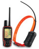
Astro and DC 30 Owner's Manual
Page 39
...the zoom range on the Rocker to set the zoom ranges for the track profile: 1. Refer to the Garmin Web site www.garmin.com/cartography/ontheTrail/ for each point appears at the bottom. 2. Topo maps. On the Tracks page or the Saved Tracks page, select TracBack. 2. On the Saved Track page, ... at the top of the page, and the distance from DEM maps, that will take you back to . 3. Select Save. To view a track profile: 1. Astro Dog Tracking System Owner's Manual GPS Applications 3. 3. To set the zoom range on the map you traveled and a track altitude profile. On the Saved Track ...
...the zoom range on the Rocker to set the zoom ranges for the track profile: 1. Refer to the Garmin Web site www.garmin.com/cartography/ontheTrail/ for each point appears at the bottom. 2. Topo maps. On the Tracks page or the Saved Tracks page, select TracBack. 2. On the Saved Track page, ... at the top of the page, and the distance from DEM maps, that will take you back to . 3. Select Save. To view a track profile: 1. Astro Dog Tracking System Owner's Manual GPS Applications 3. 3. To set the zoom range on the map you traveled and a track altitude profile. On the Saved Track ...
Astro and DC 30 Owner's Manual
Page 42
...-When routing to your next point, you are within that specified distance to your next point, press OUT to begin routing to the following point. Topo map data is used. • Copy Route-makes a copy of the route. • Delete Route-deletes the route. • Change Data Fields-selects ...different values for the two data fields at the bottom of the route when MapSource DEM U.S. Astro Dog Tracking System Owner's Manual Select Off Road Transition. 3. When you are automatically routed to the following point. • Distance-Enter a radius.
...-When routing to your next point, you are within that specified distance to your next point, press OUT to begin routing to the following point. Topo map data is used. • Copy Route-makes a copy of the route. • Delete Route-deletes the route. • Change Data Fields-selects ...different values for the two data fields at the bottom of the route when MapSource DEM U.S. Astro Dog Tracking System Owner's Manual Select Off Road Transition. 3. When you are automatically routed to the following point. • Distance-Enter a radius.

Astro and DC 30 Owner's Manual
Page 62
... for any listed location. The amount of data transferable is limited to a USB port, your Garmin dealer, Garmin Product Support (page i), or visit the Garmin Web site at www.garmin.com/products/astro/. Connect the other cable end to a USB port on the back of your computer: 1. ... might prompt you to locate the destination of the drivers for the device. When you initially connect the Astro 220 to the capacity Astro Dog Tracking System Owner's Manual Periodically check www.garmin.com for updated drivers. To achieve the best terrain details when hunting, use Garmin U.S. Topo maps.
... for any listed location. The amount of data transferable is limited to a USB port, your Garmin dealer, Garmin Product Support (page i), or visit the Garmin Web site at www.garmin.com/products/astro/. Connect the other cable end to a USB port on the back of your computer: 1. ... might prompt you to locate the destination of the drivers for the device. When you initially connect the Astro 220 to the capacity Astro Dog Tracking System Owner's Manual Periodically check www.garmin.com for updated drivers. To achieve the best terrain details when hunting, use Garmin U.S. Topo maps.


