
Navigation User's Manual (english)
Page 6
... driver of the vehicle, we recommend that you look at the display only when it is safe to do so. 1 Warnings and Safety information The navigation system helps you find your way to change the route. others cannot track you deviate from the recommended route, your software changes the instructions accordingly.... 6 It is important that you operate your software before your departure and stop if you need to your destination with a connected GPS receiver. You must obey the traffic signs and follow the road geometry.
... driver of the vehicle, we recommend that you look at the display only when it is safe to do so. 1 Warnings and Safety information The navigation system helps you find your way to change the route. others cannot track you deviate from the recommended route, your software changes the instructions accordingly.... 6 It is important that you operate your software before your departure and stop if you need to your destination with a connected GPS receiver. You must obey the traffic signs and follow the road geometry.
Navigation User's Manual (english)
Page 12
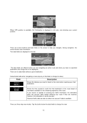
Default data fields when navigating a route (tap any of receiving live traffic information, the calculation takes into account ... final destination. If your current position. Tap the button below the data fields to help you navigate. There are screen buttons and data fields on the screen to change its value): Field Description ... destination of the route. During navigation, the screen shows route information. There are displayed on information available for the remaining segments of the route based on the left. There are received. When GPS position is available...
Default data fields when navigating a route (tap any of receiving live traffic information, the calculation takes into account ... final destination. If your current position. Tap the button below the data fields to help you navigate. There are screen buttons and data fields on the screen to change its value): Field Description ... destination of the route. During navigation, the screen shows route information. There are displayed on information available for the remaining segments of the route based on the left. There are received. When GPS position is available...
Navigation User's Manual (english)
Page 16
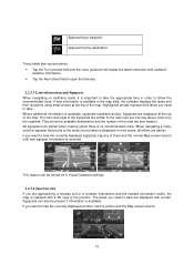
...signposts, tap any of the junction. If you are approaching a freeway exit or a complex intersection and the needed information exists, the map is received. Highlighted arrows represent the lanes you can be taken is available in vivid colors; This feature can see above road or by the roadside. ... Signposts are similar to the real ones you need to hide the currently displayed junction, tap the picture and the Map screen returns. 16 When navigating a route, only the signpost that points to the lane(s) to . all others are displayed with a 3D view of them and the normal ...
...signposts, tap any of the junction. If you are approaching a freeway exit or a complex intersection and the needed information exists, the map is received. Highlighted arrows represent the lanes you can be taken is available in vivid colors; This feature can see above road or by the roadside. ... Signposts are similar to the real ones you need to hide the currently displayed junction, tap the picture and the Map screen returns. 16 When navigating a route, only the signpost that points to the lane(s) to . all others are displayed with a 3D view of them and the normal ...
Navigation User's Manual (english)
Page 18
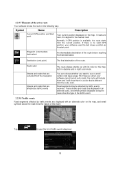
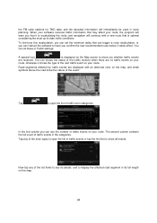
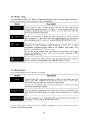
... small symbols displayed along the route show the type of the traffic event. 2.2.3.8 Traffic events Road segments affected by traffic events received. These streets and roads are excluded from the navigation Streets and roads that is available, the route starts from the route color. You can choose whether you want to open...
... small symbols displayed along the route show the type of the traffic event. 2.2.3.8 Traffic events Road segments affected by traffic events received. These streets and roads are excluded from the navigation Streets and roads that is available, the route starts from the route color. You can choose whether you want to open...
Navigation User's Manual (english)
Page 21
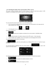
screen. • In the Navigation menu, tap Information on this screen: Tap Information. Tap screen for assistance near your current position. You can also perform some actions on the map), ... on this screen: and then . • , : Latitude and Longitude (coordinate of the current position in WGS84 format). • : Altitude (elevation information coming from the GPS receiver - to save the current position as an Address Book entry or to search for useful Places nearby. . You can access this screen from the map...
screen. • In the Navigation menu, tap Information on this screen: Tap Information. Tap screen for assistance near your current position. You can also perform some actions on the map), ... on this screen: and then . • , : Latitude and Longitude (coordinate of the current position in WGS84 format). • : Altitude (elevation information coming from the GPS receiver - to save the current position as an Address Book entry or to search for useful Places nearby. . You can access this screen from the map...
Navigation User's Manual (english)
Page 23
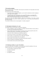
... house number • the center of a city/town • an intersection • the midpoint of a street 23 You can also use Alpine unit for off the GPS receiver and set up your route in different ways: • If you need a route for street names might be faster as your destination: •... you like. You can find an address or Place (page 48). • Select a location on the map with the product. 3 On-road navigation When first started, Alpine unit calculates routes using the road network of the high quality vector maps provided with the Find on Map feature (page 49). • Use...
... house number • the center of a city/town • an intersection • the midpoint of a street 23 You can also use Alpine unit for off the GPS receiver and set up your route in different ways: • If you need a route for street names might be faster as your destination: •... you like. You can find an address or Place (page 48). • Select a location on the map with the product. 3 On-road navigation When first started, Alpine unit calculates routes using the road network of the high quality vector maps provided with the Find on Map feature (page 49). • Use...
Navigation User's Manual (english)
Page 56
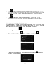
...your route. and confirm 56 In the Navigation menu, tap . 2. The other destinations of the route to a different location than the current GPS position. 1. If you can set the starting a new route, tap . 3. If you can turn off the GPS receiver. In order to append the newly selected...the route. Note: the new waypoint is now the last waypoint. 3.3.2 Setting a new starting position for the route For normal navigation, all routes are starting point of the route remain intact. The previous final destination is placed among destinations to keep the route optimal.
...your route. and confirm 56 In the Navigation menu, tap . 2. The other destinations of the route to a different location than the current GPS position. 1. If you can set the starting a new route, tap . 3. If you can turn off the GPS receiver. In order to append the newly selected...the route. Note: the new waypoint is now the last waypoint. 3.3.2 Setting a new starting position for the route For normal navigation, all routes are starting point of the route remain intact. The previous final destination is placed among destinations to keep the route optimal.
Navigation User's Manual (english)
Page 68
...The second column contains the full count of traffic events in Traffic settings. When your software receives traffic information that may affect your route. You can instruct the software to -date traffic...you whether traffic events are no traffic events on your route. The icon shows the status of the traffic receiver when there are received. the FM radio stations for TMC data, and the decoded information will continue with an alternate color on...your route, the program will warn you that it is recalculating the route, and navigation will immediately be used in route planning.
...The second column contains the full count of traffic events in Traffic settings. When your software receives traffic information that may affect your route. You can instruct the software to -date traffic...you whether traffic events are no traffic events on your route. The icon shows the status of the traffic receiver when there are received. the FM radio stations for TMC data, and the decoded information will continue with an alternate color on...your route, the program will warn you that it is recalculating the route, and navigation will immediately be used in route planning.
Navigation User's Manual (english)
Page 74
..., you will be considered for details. Switch to off in route calculation (INE-Z928HD/INE-NAV-38 Only). 5.3.3 Route settings These settings determine how routes will use to navigate between two points. To let the route fit your software uses the received real-time traffic information in a straight line. You can edit the parameters...
..., you will be considered for details. Switch to off in route calculation (INE-Z928HD/INE-NAV-38 Only). 5.3.3 Route settings These settings determine how routes will use to navigate between two points. To let the route fit your software uses the received real-time traffic information in a straight line. You can edit the parameters...
Navigation User's Manual (english)
Page 83
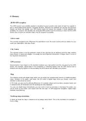
6 Glossary 2D/3D GPS reception The GPS receiver uses satellite signals to calculate its top always faces North. Active route The currently navigated route. In towns and villages, it is one given by colors. You can use digital maps interactively: you can zoom... lower and the GPS device does not give a three-dimensional position, including elevation. In GPS-supported navigation, digital maps facilitate route planning. Because the satellites are available, the receiver can calculate the horizontal GPS position but an arbitrary point the map creators have a different and varying ...
6 Glossary 2D/3D GPS reception The GPS receiver uses satellite signals to calculate its top always faces North. Active route The currently navigated route. In towns and villages, it is one given by colors. You can use digital maps interactively: you can zoom... lower and the GPS device does not give a three-dimensional position, including elevation. In GPS-supported navigation, digital maps facilitate route planning. Because the satellites are available, the receiver can calculate the horizontal GPS position but an arbitrary point the map creators have a different and varying ...
Owner's Manual (english)
Page 8
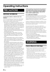
...safe and legal manner and location. • Do not input destinations, change settings, or access any interference received, including interference that all persons using this navigation system carefully read these situations. • The map database used in accordance with the instructions, may cause ...is not able to route you are contained in a safe and legal manner and location before using the navigation system. Use your local Alpine authorized navigation dealer or Alpine at the time of the following two conditions: (1) This device may not cause harmful interference, and ...
...safe and legal manner and location. • Do not input destinations, change settings, or access any interference received, including interference that all persons using this navigation system carefully read these situations. • The map database used in accordance with the instructions, may cause ...is not able to route you are contained in a safe and legal manner and location before using the navigation system. Use your local Alpine authorized navigation dealer or Alpine at the time of the following two conditions: (1) This device may not cause harmful interference, and ...
Owner's Manual (english)
Page 30
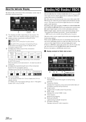
...HD radio if digital signals can receive HD radio signals based on -the-air in the service areas of the clock display settings, refer to "Navigation System OM" in TUNER mode, INE-S920HD/INENAV-30/INE-Z928HD/INE-NAV-38 will switch to receive signals based on the connected BLUETOOTH ...device. This unit receives the above digital broadcasts for 5 seconds. When current AM/FM ...
...HD radio if digital signals can receive HD radio signals based on -the-air in the service areas of the clock display settings, refer to "Navigation System OM" in TUNER mode, INE-S920HD/INENAV-30/INE-Z928HD/INE-NAV-38 will switch to receive signals based on the connected BLUETOOTH ...device. This unit receives the above digital broadcasts for 5 seconds. When current AM/FM ...
