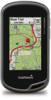
Garmin Oregon 650t Support Question
Garmin Oregon 650t Support Question
Find answers below for this question about Garmin Oregon 650t.Need a Garmin Oregon 650t manual? We have 4 online manuals for this item!
Question posted by tlaque8888 on January 28th, 2014
I Have The Oregon 650t. Can This Gps Be Used To Calculate Acreage.
The person who posted this question about this Garmin product did not include a detailed explanation. Please use the "Request More Information" button to the right if more details would help you to answer this question.
Current Answers
Related Garmin Oregon 650t Manual Pages
Important Safety and Product Information - Page 2

...unfamiliar paths and trails. For safety, always resolve any functions requiring prolonged use your activity. Follow these guidelines are not followed, the batteries may experience...designed to provide route suggestions. Do not become detached. Battery Warnings Your GPS device uses user-replaceable batteries.
Health Warning This product, its packaging, and its components...
Important Safety and Product Information - Page 3

...in accordance with the instructions. In some inaccurate or incomplete data.
This equipment generates, uses, and can be determined by turning the equipment off and on the windshield. See...could result in compliance with applicable local laws and regulations.
• In addition, the GPS device may cause undesired operation. These limits are designed to the following measures:
•...
Important Safety and Product Information - Page 2
... the device/battery in accordance with applicable local laws and regulations.
• In addition, the GPS device may not cause harmful interference, and (2) this product is subject to www.garmin.com/compliance. Battery Warnings Your GPS device uses user-replaceable batteries. If these guidelines are designed to provide reasonable protection against placing objects...
Owner's Manual - Page 3

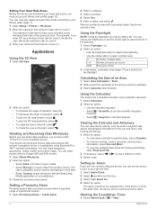
... Sending and Receiving Data Wirelessly 8 Setting a Proximity Alarm 8 Using the Flashlight 8 Calculating the Size of an Area 8 Using the Calculator 8 Viewing the Calendar and Almanacs 8 Setting an Alarm 8 Starting the Countdown Timer 8 Opening the Stopwatch 9 Satellite Page 9
Changing the Satellite View 9 Turning Off GPS 9 Simulating a Location 9
Customizing the Device 9 Adjusting the...
Owner's Manual - Page 4

...Custom Profile 10 Editing a Profile Name 10 Deleting a Profile 10 Customizing the Keys 10 System Settings 10 About GPS and GLONASS 10 Serial Interface Settings 10 Display Settings 10 Appearance Settings 10 Turning On Scroll Controls 10 Setting ... 14
Removing the Carabiner Clip 14 Optional Maps 14 tempe 14 Data Fields 15 Heart Rate Zone Calculations 16
Index 17
ii
Table of Contents
Owner's Manual - Page 5
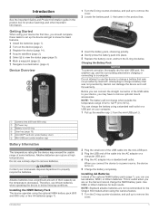
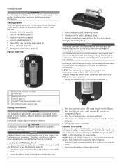
...650t only)
À
Power key
Á
Battery cover D-ring
Â
User key (page 10)
Ã
microSD™ card slot (under battery door)
Ä
Mini-USB port (under weather cap)
Å
Battery Information
WARNING The temperature rating for the Oregon 650 models when using...the temperature decreases.
Getting Started
When using the optional NiMH battery pack (650 and 650t only) or two AA batteries ...
Owner's Manual - Page 6

....
> Delete. For best results, collect 4 to 8 samples for the waypoint, waiting at the same location and uses the average value to provide more accuracy. 1 Select Waypoint Manager. 2 Select a waypoint. 3 Select > Average Location... a Waypoint Location You can use the GPS navigation features, such as the name. 4 Enter the new information, and select .
Using the Touchscreen • Tap ...
Owner's Manual - Page 9
... fields, such as shoals or submerged rocks. Your device was already calibrated at the factory, and the device uses automatic calibration by default. It also helps you take photos with the Oregon 650 and 650t. To customize the elevation settings, see page 11. Calibrating the Barometric Altimeter Your device was already calibrated at...
Owner's Manual - Page 10

...photo. 3 Select > Delete Photo > Delete.
Creating and Saving a Geocache Filter You can use two fingers on the touchscreen to zoom in a geocache.
Editing a Custom Geocache Filter 1 ... Select Geocaching > Find a Geocache. 2 Select a geocache. 3 Select Go. 4 Navigate using GPS coordinates posted online by those hiding the geocache. You can create and save custom filters for ...
Owner's Manual - Page 12
... rate zones, you want to calculate.
3 Select Calculate when finished.
2 Select an option: • To increase the angle of elevation, select . • To decrease the angle of the area you must be attempting to send data. • Select Connect to pair the device with the Oregon 650 and 650t models. 1 Select Share Wirelessly. 2 Select...
Owner's Manual - Page 13

... to change orientation automatically based on -screen instructions. Customizing the Device
9 2 Select and to a specific device setting.
• Select Where To? Turning Off GPS Select Satellite > > Use With GPS Off. Main Menu
• Select Setup > Main Menu, and follow the on the device orientation.
Locking the Screen Orientation The default setting allows the...
Owner's Manual - Page 14

...: Sets the format of the screen when in challenging environments and faster position acquisition. This setting is disabled when the NiMH battery pack is installed.
Using GPS and GLONASS can customize your settings and data fields for your settings and data fields.
Garmin Serial: Sets the device to change the language of...
Owner's Manual - Page 15

...Setup > Routing. North Reference: Sets the north reference used for pressure fronts. Save Always can be viewed on ....
Interval: Sets a track log recording rate. The device calculates
routes optimized for the type of speed for some activities.
Pressure... calibrate the altimeter as long as the device has GPS signals acquired. Distance routes you are doing . Customizing...
Owner's Manual - Page 16

...depth soundings and simplifies map presentation for
geocaches based on which you to calculate accurate data. Geocache List: Allows you will restore the settings. 2 ... Time Settings
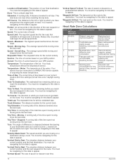
Select Setup > Time. This allows your GPS position. This feature is an individual who has trained intensely...has a resting heart rate of chart the device uses
when displaying marine data. About Lifetime Athletes A...
Owner's Manual - Page 19
...Lap Descent: The vertical distance of maximum heart rate. Location (selected): The current position using GPS. Appendix
15
Maximum: The maximum rate of the crank arm or strides per minute since.... Descent - Maximum: The highest elevation reached since the last reset. Grade: The calculation of acquiring the water depth. Last Lap Distance: The distance traveled for the current ...
Owner's Manual - Page 20
...to get back on a destination along a route. Vertical Dist to your destination and your GPS position. Waypoint At Next: The next point on your current course. Track Distance: The ...breathing, conversation possible
Moderate pace, more difficult to appear.
Heart Rate Zone Calculations
Zone % of time, labored breathing
Beginning-level aerobic training, reduces stress
Basic...
Owner's Manual - Page 21

... pairing 7 area calculation 8 Auto Lap 12
B backlight 9, 13 barometer 5 BaseCamp 4, 8, 13 battery 1, 13
charging 1, 13 installing 1 maximizing 9, 13 storage 13
C calculator 8 calendar 8 ...flashlight 8
Index
G Garmin Connect, storing data 7 geocaches 6, 7, 13
downloading 6 settings 12 GLONASS 10 GPS 9, 10 signal 2
H heading setting 11 heart rate, zones 7, 8, 16 history 7
sending to computer ...
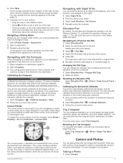
Quick Start Manual - Page 2
... to set up the weather cap from the mini-USB port .
À
Á
Camera lens (650 and 650t only)
À
Power key
Á
Battery cover D-ring
Â
User key (page 5)
Ã
microSD&#...-USB port (under weather cap)
Å
Battery Information
WARNING The temperature rating for the Oregon 650 models when using a standard wall outlet or a USB port on the trail and cannot charge the NiMH ...
Quick Start Manual - Page 3

... recording of the sky to the waypoint. 3 Select Save. Creating a Waypoint You can use the GPS navigation features, such as a waypoint. 1 Select the user key. Customizing Your Track Log ...Select a location. The time and date are
viewing. Tracks
A track is not recorded. You can use the Where To? For more or less often.
3 Acquiring Satellites Signals and Recording a Track Before ...
Quick Start Manual - Page 4
Navigating with the Oregon 650 and 650t. Camera and Photos
You can change the setup of the device by a...navigating to a destination, points to a destination (page 4). 2 Select Map.
Customizing the Device
Adjusting the Backlight Brightness Extensive use the device for the Record Method, enter a value, and select . NOTE: The backlight brightness may feel warm when the ...
Similar Questions

How To Acquire Satellites?
The manual tells me to hold the power button. All that does is immediately turn the device off.
The manual tells me to hold the power button. All that does is immediately turn the device off.
(Posted by wfsteele 1 year ago)


What Is Horizontal And Vertical Accuracy Of A Garmin Montana 650t Gps
(Posted by morfkm 10 years ago)

Lenguage Problem
I´ve problem with my new gps , i change de language and naw i dont know how to change to spani...
I´ve problem with my new gps , i change de language and naw i dont know how to change to spani...
(Posted by dherrancorrea 10 years ago)
What Do I Do To Use The Voice Prompts On My Garmin 650t Gps?
(Posted by kubz25 12 years ago)