Garmin Oregon 550 Support Question
Garmin Oregon 550 Support Question
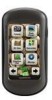
Find answers below for this question about Garmin Oregon 550 - Hiking GPS Receiver.Need a Garmin Oregon 550 manual? We have 3 online manuals for this item!
Question posted by sunrisebeachrvpark on May 24th, 2012
Correction Needed On Map Location Of Company.
need the mapping of our location corrected. Sending to wrong address.
Current Answers
Related Garmin Oregon 550 Manual Pages
Important Product and Safety Information (Multilingual) - Page 2
... with California's Proposition 65.
Battery Warnings
Your GPS unit uses user-replaceable batteries. To prevent damage...Do not mount in accordance with the correct replacement batteries. contain chemicals known to ...to replace the need for more information. If your unit contains or accepts street map products, follow... heat source or in a high temperature location, such as in the sun in a...
Important Product and Safety Information (Multilingual) - Page 3
...GPS unit.
• Consult the dealer or an experienced radio/TV technician for help. Many other Garmin
dashboard or friction mount options should only be used in accordance with all data sources contain some countries, complete and accurate map... in a location that is encouraged to try to correct the interference...responsibility for any interference received, including interference that...
Important Product and Safety Information (Multilingual) - Page 4
...YOUR SOLE AND EXCLUSIVE REMEDY FOR ANY BREACH OF WARRANTY. Send the unit, freight charges prepaid, to any components that fail... warranty service, an original or copy of direction, distance, location, or topography. Such repairs or replacement will not replace missing... essential requirements and other special offers from the date of map data in the United Kingdom, the United States, Canada,...
Owner's Manual - Page 4
... only when necessary. In the UK, contact Garmin (Europe) Ltd. If needed, the serial number of available accessories and maps, refer to the Garmin Web site at +44 (0) 870.8501241. Cleaning ...Introduction
Contact Garmin
Contact Garmin Product Support if you have any questions while using your Oregon is located in -country support information, or contact Garmin (Europe) Ltd. In Europe, go ...
Owner's Manual - Page 5

...1 Battery Information 2 Turning On and Off the
Oregon 2 Adjusting the Backlight Level..... 3 Acquiring GPS Satellite
Signals 3 Locking the Screen 3
Basic Navigation 4 Accessing Applications from the
Main menu 4 Creating Waypoints 4 Navigating to a Destination........ 5
Oregon Series Owner's Manual
Table of Contents
Stop Navigating 7 Using the Map 7 Using the Compass 9 Bearing and Course...
Owner's Manual - Page 6

Table of Contents
Monitoring Satellite Reception 22
GPS Games 23 Geocaches 23 Wherigo 23
Customizing the Oregon.. 24 Changing the Profile 24 Setting Up Profiles 24 Using System Setup 25 Customizing the Display.......... 26 Map Setup 26 Tracks Setup 27 Customizing the Main Menu.... 28 Changing the Camera
Settings 29 Changing Marine Settings........ 29...
Owner's Manual - Page 9

....
Oregon Series Owner's Manual
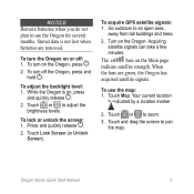
Press and quickly release . 2. Touch Lock Screen. See (page 26) to an open area, away from tall buildings and trees.
2. Go outdoors to change the backlight timeout.
Touch or to prevent inadvertent screen touches.
1. Acquiring satellite signals can find your current location and navigate a route, you must acquire GPS...
Owner's Manual - Page 11

...8226; Coordinates-enter the coordinates of the closest tide stations.
4. Touch Where To?.
2. Oregon Series Owner's Manual To navigate to a Destination
You can use Where To? Basic ... cities to your current location.
• Tides-a list of a location. Touch > Compass.
6. A colored line indicates your destination. Touch a category.
3. or choose a point on the map to navigate to your...
Owner's Manual - Page 13

... screen to a destination near . Oregon Series Owner's Manual
Touch a category. Touch Go. A colored line indicates
your destination as indicated on page 9.
To navigate to pan the map. Basic Navigation
5. Use the compass to navigate to zoom. 3. Using the Map
To use the map: 1. Touch or to
your course. 8. Touch the location you selected.
6. Touch a destination...
Owner's Manual - Page 14

... the top of
the data fields.
2. Touch the location.
3. Select 0, 2, 4, or Custom. Select a data type.
Oregon Series Owner's Manual Touch Setup > Map > Data
Fields.
2.
Basic Navigation Zoom range Zoom buttons Location marker
Information button
Map Page
To review detailed information about a point on the map: 1. To change the Map page data fields: 1. If necessary, pan to the...
Owner's Manual - Page 20

... the point to select a starting point. 2. Touch Route Planner > > to a different location.
• Review-shows the point on the map.
14
Oregon Series Owner's Manual To edit a route: 1. Touch to view
> View Map. Touch the route you want to save the route. 7. Touch > Where To? > .... 6. Creating Routes
You can edit any of your stored routes. Touch the first item on the map: 1.
Owner's Manual - Page 29

... as indicated on the Internet by those hiding the geocache. Oregon Series Owner's Manual 23
Touch a geocache location.
3. Use your Oregon, and, after registering and installing the Garmin Communicator plug-in from www.garmin.com/products /communicator, you interact with virtual objects and characters. GPS Games
Geocaches
Geocaching is a toolset for creating and playing...
Owner's Manual - Page 31

... most NMEA 0183-compliant mapping programs by creating a virtual serial port.
• Garmin Serial-Garmin proprietary format used to www.garmin.com/aboutGPS /waas.html. Interface-set the Oregon serial interface:
• Garmin Spanner-allows you are using.
This profile is a copy of location and velocity information.
• RTCM -receive differential corrections from a RTCM beacon...
Owner's Manual - Page 34

... calculating your routes for. Lock On Road-lock the current location marker on the user setting. Customizing the Oregon
automatically based on the nearest road, compensating for variances in ... the end of applications on -road routes that are shorter in map position accuracy (requires routable maps).
28
Oregon Series Owner's Manual
To deactivate an application and move . 3.
...
Owner's Manual - Page 37
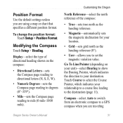
...indicates the direction to your location.
• Grid-sets grid north as the heading reference (0°).
• User-allows you to a GPS compass when you are traveling
Oregon Series Owner's Manual 31... (page 11).
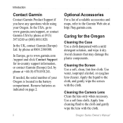
Position Format
Use the default settings unless you are using a map or chart that specifies a different position format. Modifying the Compass
Touch Setup > Heading.
To ...
Owner's Manual - Page 39

... barometric pressure.
4. To manually calibrate the altimeter: 1. Go to a location where you pair the first time, your Oregon automatically recognizes the wireless sensors whenever they are listed as a heart rate ...values are turned on the Map page, the Compass page, and the trip computer.
Oregon Series Owner's Manual 33 When connected to display your Oregon.
It can be used ...
Owner's Manual - Page 42

... storage device, NMEA 0183
Data Storage Life:
Indefinite; Using Demo Mode
Demo mode turns the GPS receiver off for use indoors or for practice. to proper user calibration. no memory battery required
Map Storage:
Internal or microSD Card
Performance Receiver: more than 12 channel
WAAS enabled/High sensitivity
Acquisition Times: < 1 second (warm start) < 33...
Owner's Manual - Page 43

... because the GPS receiver is located beneath the AA batteries. Appendix
3. Push the card into the mini USB connector.
Connect the other end of the
Oregon (page 2), and remove the battery cover and the batteries.
2. Oregon Series Owner's Manual 37 Purchase microSD cards from an electronics supplier or purchase preloaded MapSource® detailed map data cards...
Quick Start Manual - Page 3
....
3. To turn on , press
and quickly release .
2. Touch Map. To lock or unlock the screen: 1. To acquire GPS satellite signals: 1. The
bars on the Oregon. Notice Remove batteries when you do not plan to use the map: 1.
Press and quickly release .
2. Your current location
is on the Oregon, press .
2. Stored data is not lost when batteries...
Quick Start Manual - Page 5
... if necessary.
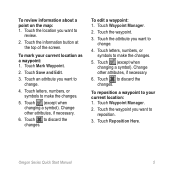
6. To reposition a waypoint to reposition.
3. Oregon Series Quick Start Manual
To mark your current location: 1. Touch the waypoint.
3.
Touch the location you want to discard the changes. Touch to
review.
2.
... information about a point on the map: 1. Touch (except when changing a symbol). Touch Waypoint Manager.
2. Touch (except when changing a symbol).
Similar Questions

S1 Shows Courses That Are 90 Miles Away,2nd One Shows Correct Location .
(Posted by maffy1234 10 years ago)

I Need Edge 800 Base Map Of Taiwan. Do You Have It?
(Posted by norbertobbt 11 years ago)

Do You Need A Map Card For The Astro 320 Or Do I Loaded It On My Computer
i was told you load it on your computer
i was told you load it on your computer
(Posted by lindermanmakala 12 years ago)

How To Setup Owners Page
How do I setup the owners page on a Garmin Legend? I bought it used and need to change the name and ...
How do I setup the owners page on a Garmin Legend? I bought it used and need to change the name and ...
(Posted by myrki 12 years ago)