Garmin GPSMAP 96C Support Question
Garmin GPSMAP 96C Support Question
Find answers below for this question about Garmin GPSMAP 96C - Hiking.Need a Garmin GPSMAP 96C manual? We have 3 online manuals for this item!
Question posted by sayre31 on July 19th, 2017
How Do I Download Caches Through Firefox On Aol?
Since switching to AOL I can no longer download geocaches thru firefox. When I try to connect my GPS, it says plugin not recognized.
Current Answers
Related Garmin GPSMAP 96C Manual Pages
Owner's Manual - Page 2

...subsidiaries, registered in this manual may not be reproduced, copied, transmitted, disseminated, downloaded or stored in any storage medium, for current updates and supplemental information concerning the...the Garmin Web site (www.garmin.com) for any revision hereto is strictly prohibited. GPSMAP®, AutoLocate®, TracBack®, BlueChart®, and MapSource® are trademarks of...
Owner's Manual - Page 3
... >
The Basic Operation section provides you for choosing the Garmin GPSMAP 96/96C, an unsurpassed portable aviation receiver that utilizes the proven performance of the unit features and ...how to avoid unsafe practices.
96/96C Owner's Manual
The Appendix contains information such as an overview of Garmin GPS, full-featured mapping and navigation for aviation, marine,...
Owner's Manual - Page 5

... 122
Introduction >
Appendix 123 Specifications 123 Accessories 124 What are Map Datums 125 What is Position Format 125 What is WAAS 126 What is Differential GPS (DGPS 126 Interfacing the GPSMAP 96/96C 129 Messages 130 Data Field Options 132 License Agreement and Warranty 134 Declaration of Conformity (DoC 137
Index 138
96...
Owner's Manual - Page 7
..., or other factors that may result in injury or property damage. The GPSMAP 96/96C is available to us at a reasonable cost.
In some extent.
Virtually all GPS equipment, including the GPSMAP 96/96C. This product should be used . The Global Positioning System (GPS) is operated by the United States government, which is a precision navigation device...
Owner's Manual - Page 8

... the unit's memory without the need for 30 minutes. It is waterproof to MapSource). Water Immersion The GPSMAP 96/96C is always a good practice to back up important user data by manually recording it or downloading it to a PC (transferring it to IEC Standard 60529 IPX7. Prolonged submersion can cause damage to wipe...
Owner's Manual - Page 9
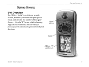
Getting Started
Unit Overview
The GPSMAP 96/96C is an all-in basemap, Jeppesen aviation database, and auto routing to provide you with automatically generated turn-by-turn directions.
perfect for air, land, or water. Internal antenna
Keypad
256-Color TFT backlit screen
96/96C Owner's Manual
Getting Started > This portable GPS navigator features a 256...
Owner's Manual - Page 12
...quickly release the POWER key.
2.
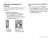
Press ENTER or QUIT to decrease the brightness. 3. To adjust the contrast level: (GPSMAP 96 only): 1. To adjust the backlight level: 1. Press ENTER or QUIT to decrease the contrast.
3.
Press the...
You may want to adjust the backlight to see the screen better.
GPSMAP 96C Backlight Adjustment
GPSMAP 96 Backlight and Contrast Adjustment
96...
Owner's Manual - Page 13
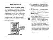
...unit
powers on the Warning Page it is assumed that you understand that the GPSMAP 96 and GPSMAP 96C are intended as an aid to situational awareness only. That it does not ...sky to receive satellite signals.
That the navigation information and obstacle data provided by the GPSMAP 96 and GPSMAP 96C is shipped from the factory in AutoLocate mode, which allows the receiver to continue. ...
Owner's Manual - Page 16
... Operate Unit Features
The GPSMAP 96/96C unit's advanced keypad system is Yellow)
GPSMAP 96C
On-Screen Buttons (Buttons are
grayed-out when inactive)
Data Fields
96/96C Owner's Manual Use the ROCKER to page 122. In many instances a remedy is controlled by the ROCKER.
Basic Operation >
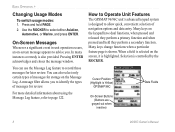
Changing Usage Modes
To switch usage modes: 1. You can...
Owner's Manual - Page 20
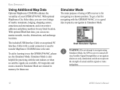
... navigation shown are retained in Simulator Mode are only simulations and do not represent the strength of using Simulator Mode, the GPS receiver is a good idea to use the GPSMAP 96/96C, please use . Start Simulator Option
Warning: Do not attempt to the unit. The included USB Interface Cable or an optional PC...
Owner's Manual - Page 22
...or QUIT to increase the
simulated speed.
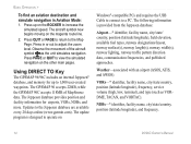
Press in Aviation Mode: 1.
The GPSMAP 96 accepts 22MB, while the GPSMAP 96C accepts 118MB of the aircraft symbol as VORDME, TACAN, and VORTAC). The ...and facility information for up on
Windows®-compatible PCs and requires the USB Cable to connect to a PC. Updates to adjust the zoom level. Observe the movement of MapSource data...
Owner's Manual - Page 26
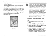
...is available in instrument conditions. The approaches provided in mind that the airport must have a published approach (GPS, RNAV, VOR, NDB, localizer, or ILS) and only the final course segment (from
the third field...TO D to quickly retrieve and select available approaches. The GPSMAP 96/96C removes the destination airport from the Go To and replaces it with the sequence of navigation ...
Owner's Manual - Page 54
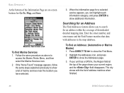
... with the list of address matches when finished.
46
96/96C Owner's Manual To find Marine Services 1. When the information page for an address within the coverage of the page shows your unit has a GPS fix, the Region field at the top of downloaded detailed mapping data. Searching for Go To, Map, and...
Owner's Manual - Page 68
... Menu. Main Pages >
Marine Mode Options
Map Page
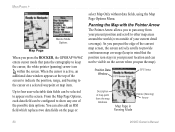
When you press the ROCKER, the GPSMAP 96/96C enters cursor mode that pans the cartography to keep in mind that the position icon stays in Panning...which replaces two data fields on the screen when you pan the map). Position Data Window
GPS Status
Description of map point from your present position and scroll to other map areas around the...
Owner's Manual - Page 71
... is shown when the selected zoom range is covered by both the internal bundled database and downloaded MapSource detailed mapping information, the cartography with more detailed coverage available through the use of the... range scales from the Map Page: 1. to 800 nm. (20 ft. The GPSMAP 96/96C shows cartography as long as there is shown at the bottom left of the optional MapSource data...
Owner's Manual - Page 87
... appearing in red (dark gray) are predicted to control the screen of marine chart items when using downloaded marine charts (i.e. Unlighted Obstruction 1000 ft AGL and higher.
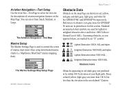
Lighted Obstruction below 1000 ft AGL. Main Pages...gray and dark gray, light gray, and white for the GPSMAP 96C and GPSMAP 96 respectively. Aviation Navigation-Text Setup Use the Avtn Nav-Text Page to obstacle icon gray...
Owner's Manual - Page 92

...you have downloaded Garmin MapSource® mapping data that contains additional map detail, you have saved. If this additional data is not loaded, these options are included in the GPSMAP 96/96C basemap and... Intersections. Main Menu >
• Alarm Clock-This feature allows you to use the GPSMAP 96/96C as an Alarm Clock.
• Nav/Sonar Alarms-This feature allows you to select from ...
Owner's Manual - Page 131
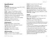
... operating the GPSMAP 96/96C in quad helix, remote antenna capability Keypad: Nine multifunction backlit keys Operating Range: 5 to 158oF (-15 to 70oC)1
Performance
Receiver: WAAS enabled, 12 parallel channel Acquisition Time: Warm: Approximately 15 seconds Cold: Approximately 45 seconds AutoLocate™: Approximately 2 minutes Update Rate: Once per second, continuous
GPS Accuracy
Position...
Owner's Manual - Page 137
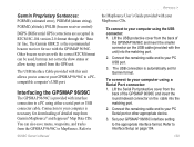
...automatically set for downloading of the GPSMAP 96/96C and insert the round indexed connector on page 104.
96/96C Owner's Manual 129
Connection to your GPSMAP 96/96C interface setting to...(estimated error), PGRMM (datum string), PGRMZ (altitude), PSLIB (beacon receiver control)
DGPS (Differential GPS) corrections are accepted in RTCM SC-104 version 2.0 format through the 'Data In' line. ...
Quick Reference Guide - Page 2
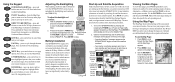
...show the Backlight Adjustment
Slider. Using the Keypad
POWER/BACKLIGHT Key-press and hold to switch operating
modes. QUIT
QUIT Key-press and release to increase the brightness level. ROCKER Key... the map scale. GPSMAP 96C Backlight Adjustment
2. A polarity diagram is not lost when batteries are in or out. Extensive use the Map Page: 1. Status Bar 3D GPS indicator
Received Satellite
icon...
Similar Questions


Garmin Edge 500 Wont Go Into Mass Storage Mode
(Posted by Peser 9 years ago)


Antagent Downloaded And Installed, Usb Connected - Nothing Happens. Ideas?
USB with training info connected, unable to access any information.
USB with training info connected, unable to access any information.
(Posted by denmar 11 years ago)