Garmin GPSMAP 62st Support Question
Garmin GPSMAP 62st Support Question
Find answers below for this question about Garmin GPSMAP 62st.Need a Garmin GPSMAP 62st manual? We have 4 online manuals for this item!
Question posted by andreassv1eoi on August 4th, 2011
Grid Locator-qth Locator
Hi,can GPSMAP62st calculate GRID LOCATOR-QTH from Longtiude and Latitude??From Main Menu go to Settings then go to Units see; hddd mm.mmm' change at Maidenhead.Is possible to do this steps from Main Menu??if yes GPSMAP62st can calculate the Grid Locator.Please answer me,i want to know it for buy it!!...Thanks a lot...
Current Answers
Related Garmin GPSMAP 62st Manual Pages
Important Safety and Product Information - Page 2
...GPS device uses user-replaceable batteries. Keep your windshield clean to help ensure that may use your local waste disposal department to dispose of time spent viewing the device screen while driving.
• Do not input destinations, change settings...life span or may apply. Do not mount in a high-temperature location, such as the steering wheel, the foot pedals, or the transmission ...
Important Safety and Product Information - Page 3
...radio frequency energy and may cause harmful interference to
Such repairs or replacement will be located only in a particular installation.
FCC Compliance This device complies with the instructions.
...of any components that fail in a location that the customer shall be free from the date of Garmin; Some state laws prohibit drivers from the GPS device. It is the user's ...
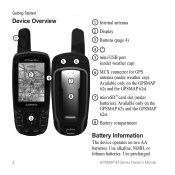
Owner's Manual - Page 6
...8
3
2
1 Internal antenna
2 Display
3 Buttons (page 4)
4
5 mini-USB port (under weather cap)
6 MCX connector for GPS antenna (under batteries). Available only on the GPSMAP 62s and the GPSMAP 62st.
8 Battery compartment
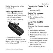
Battery Information
The device operates on the GPSMAP 62s and the GPSMAP 62st.
7 microSD™ card slot (under weather cap). Use alkaline, NiMH, or lithium batteries.
Owner's Manual - Page 7
... a
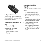
language. Wait while the device searches for best results (page 37). Setting Your Language 1. Use the Rocker to acquire signals.
1. A question mark flashes while the device determines your location. 4.
Replace the battery cover.
If necessary, turn counterclockwise and pulling up.
2. The GPS bars indicate satellite
3 NiMH or lithium batteries for
satellites. Remove the...
Owner's Manual - Page 8
... current location as a waypoint.
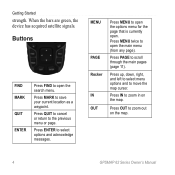
Press MARK to select options and acknowledge messages. Press IN to open .
Press MENU twice to zoom in on the map.
4
GPSMAP 62 Series Owner's Manual Press OUT to open the options menu for the page that is currently open the main menu (from any page).
MENU
PAGE Rocker IN OUT
Press MENU to...
Owner's Manual - Page 9
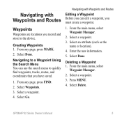
... use the search menu to quickly find waypoints, tracks, routes, and coordinates that you have saved.
1. From any page, press MARK. 2. Enter the new information. 5. From any page, press FIND. 2. Select Go. Select Done.
GPSMAP 62 Series Owner's Manual
5 Deleting a Waypoint 1. Navigating with Waypoints and Routes
Waypoints
Waypoints are locations you record and...
Owner's Manual - Page 12
...with Waypoints and Routes
Additional Maps
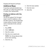
To purchase preloaded detailed map data cards, go to search for addresses, cities, and other locations. Press FIND.
2. NOTE: Not all map data provides postal code searching.
5. The detailed maps contain millions of points ... City Navigator maps to http://buy.garmin.com or contact your Garmin dealer. Select Go.
8
GPSMAP 62 Series Owner's Manual
Owner's Manual - Page 15
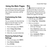
... this device is found on the map. Restoring Default Page Settings
1. GPSMAP 62 Series Owner's Manual
Using the Main Pages
Map
The position icon represents your current direction of the page.
• Select Track Up to show your location on the following pages: map, compass, main menu, and trip computer. Select an orientation:
• Select North...
Owner's Manual - Page 16
...allows you want to measure to. Press quit to stop measuring. GPSMAP 62 Series Owner's Manual note: Higher detail settings may cause the map to redraw slowly.
• Shaded Relief-shows...the Main Pages
Measuring Distance You can move the cursor around the map to measure distance from your map.
From the map, press MENU. 2. The device automatically begins measuring from the current location....
Owner's Manual - Page 18
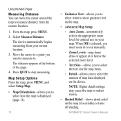
... 'N Go
NOTE: Sight 'N Go is available only with the GPSMAP 62s and GPSMAP 62st.
GPSMAP 62 Series Owner's Manual Compass Setup Options From the compass, press menu, and select Setup Heading.
• Display-shows the type of directional heading on the compass:
◦◦ Directional Letters-sets the compass reading to directional letters (N, S, E, W).
◦◦ Numeric...
Owner's Manual - Page 19
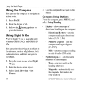
... compass calibration (page 13).
Select Calibrate Altimeter.
3. ◦◦ Grid-sets grid north as the heading reference (0°).
◦◦ User-sets the magnetic variation value.
• Go To Line/Pointer-allows you to select how the course is available only with the GPSMAP 62s and GPSMAP 62st.
GPSMAP 62 Series Owner's Manual
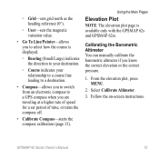
15 Calibrating the Barometric Altimeter...
Owner's Manual - Page 22
... /communicator.
4. Follow the on -screen instructions to download geocaches to your device (page 34).
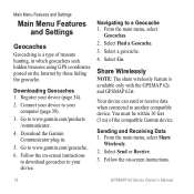
2. Main Menu Features and Settings
Main Menu Features and Settings
Geocaches
Geocaching is available only with the GPSMAP 62s and GPSMAP 62st. Follow the on -screen instructions.
18
GPSMAP 62 Series Owner's Manual Select a geocache.
4.
You must be within 10 feet (3 m) of treasure...
Owner's Manual - Page 24
... oriented with the moon phase.
20
GPSMAP 62 Series Owner's Manual
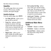
You can use this location to select whether the satellite page is available only when you turn the GPS on the map. Main Menu Features and Settings
Satellite
The satellite page shows your GPS position using the Garmin AutoLocate feature. Satellite Settings From the satellite page, press...
Owner's Manual - Page 25
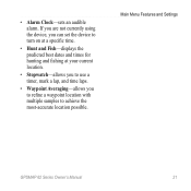
... Fish-displays the predicted best dates and times for hunting and fishing at your current location.
• Stopwatch-allows you to use a timer, mark a lap, and time laps.
• Waypoint Averaging-allows you to refine a waypoint location with multiple samples to achieve the most-accurate location possible. Main Menu Features and Settings
GPSMAP 62 Series Owner's Manual
21
Owner's Manual - Page 26
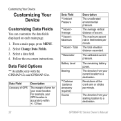
... GPSMAP 62s and GPSMAP 62st.
The average vertical distance of the crank arm or strides per minute. Select Change Data Fields. 3. The maximum ascent rate in feet/meters per minute. Revolutions of ascent. The calibrated current pressure. Follow the on each main page.
1. Data Field **Ambient Pressure
**Ascent Average **Ascent Maximum
**Ascent - From a main page, press meNu...
Owner's Manual - Page 27
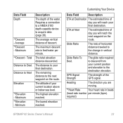
...current location above or below sea level. Glide Ratio To Dest.
The distance to the change ...in beats
(heart rate monitor per minute.
The altitude of day you will reach the next waypoint on the route. ETA at Destination The estimated time of your final destination.
GPS... reached. The average vertical distance of the GPS signal. The maximum descent rate in feet/meter...
Owner's Manual - Page 28
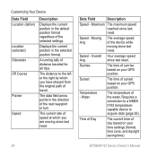
... original path of day based on your time settings (format, time zone, and daylight saving time).
Speed -
Sunrise
The time of sunset based on your GPS position. Sunset
The time of sunrise based on your GPS position. Time of Day
The current time of travel. GPSMAP 62 Series Owner's Manual
The distance to acquire...
Owner's Manual - Page 30
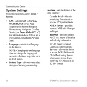
...output of location and velocity information.
◦◦ RTCM Radio Technical Commission for Maritime Services-allows the device to www.garmin.com/aboutGPS/waas .html.
• Language-sets the text...in an SC-104 format.
26
GPSMAP 62 Series Owner's Manual Customizing Your Device
System Settings
From the main menu, select Setup > System.
• GPS-sets the GPS to Normal, WAAS/EGNOS (Wide Area...
Quick Start Manual - Page 3
... to select a
language. Wait while the device searches for satellites. The GPS bars indicate satellite strength. Use the Rocker to acquire signals.
1. A question mark flashes while the device determines your location.
4.
Quickly press to an open the backlight status page. GPSMAP 62 Series Quick Start Manual
Replace the battery cover. Turning the Device...
Quick Start Manual - Page 6
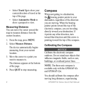
... page. 4. From the map, press MENU. 2. Calibrating the Compass
notice Calibrate the electronic compass outdoors. The distance appears at the top of the page.
• Select Automotive Mode to .
Do not stand near objects that direction until the arrow is available only with the GPSMAP 62s and GPSMAP 62st. Measuring Distance You can move...
Similar Questions

Heart Rate Monitor Pairing Trouble!
Lately, I updated my Edge 810 for 5.0 version, and since I did that, my Edge recognize the sensors s...
Lately, I updated my Edge 810 for 5.0 version, and since I did that, my Edge recognize the sensors s...
(Posted by clement425 8 years ago)

My 62st Does Not Leave Bread Crumbs. Can U Tell How To Get Them Back
(Posted by spmiske 9 years ago)

Garmin Edge 500 Wont Go Into Mass Storage Mode
(Posted by Peser 9 years ago)
Date Format For Geocaches
I want the date format for log entries saved onto the etrex set to DD/MM/YYYY (which is normal for A...
I want the date format for log entries saved onto the etrex set to DD/MM/YYYY (which is normal for A...
(Posted by sunshine66254 11 years ago)

How Do I Set It Up To Show The Grid Reference Of The Present Location
(Posted by brian71258 11 years ago)