Get support for Garmin eTrex 10

Garmin eTrex 10 Support Question

Garmin eTrex 10 Support Question

Find answers below for this question about Garmin eTrex 10.
Need a Garmin eTrex 10 manual? We have 2 online manuals for this item!
Question posted by brian71258 on October 27th, 2012

How Do I Set It Up To Show The Grid Reference Of The Present Location

The person who posted this question about this Garmin product did not include a detailed explanation. Please use the "Request More Information" button to the right if more details would help you to answer this question.

Current Answers

There are currently no answers that have been posted for this question.
Be the first to post an answer!

Remember that you can earn up to 1,100 points for every answer you submit. The better the quality of your answer, the better chance it has to be accepted.

Related Garmin eTrex 10 Manual Pages

Owner's Manual - Page 8

... sky to http://www.garmin.com/aboutGPS. Satellite Signals After the device is turned on the GPS position. The time and date are solid green, your device has acquired satellite signals. Registering ... receipt, or a photocopy, in a safe place. 8 eTrex Owner's Manual When the GPS bars on the backlight page (page 40) are set automatically based on , it begins acquiring satellite signals.
Owner's Manual - Page 16

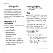
...with your destination. Navigate using the map or compass. 1. When you travel, moves. To customize the map settings, see page 28. Map represents your route is marked with a magenta line. 5. As you are navigating ... view different areas. • Select ▲ and ▼ to any saved location in and out of the map. 16 eTrex Owner's Manual You can use the map (page 16) or compass (page 17...
Owner's Manual - Page 17

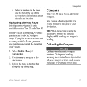
...pointer or a course pointer to navigate to the destination. 3. eTrex Owner's Manual 17 • Select a location on the eTrex 20 and eTrex 30. TIP: When the device is only available on the map... a Driving Route Driving route navigation is using the automotive profile, the compass displays GPS heading, not magnetic heading. To improve heading accuracy, do not stand near objects that...
Owner's Manual - Page 18

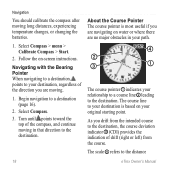
...Start. 2. Select Compass. 3. As you are moving. 1. Begin navigation to the distance 18 eTrex Owner's Manual About the Course Pointer The course pointer is based on your original starting point....Turn until points toward the top of drift (right or left) from the course. The scale ➍ refers to a destination (page 16). 2. The course line to your destination is most useful if you are no...
Owner's Manual - Page 20

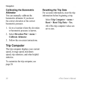
...Data For accurate information, reset the trip information before beginning a trip. To customize the trip computer, see page 28. 20 eTrex Owner's Manual Select Trip Computer > menu > Reset > Reset Trip Data > Yes. Select Elevation Plot > menu > Calibrate ...barometric pressure. 1. All of the trip computer values are set to a location where the elevation or barometric pressure is known. 2.
Owner's Manual - Page 21

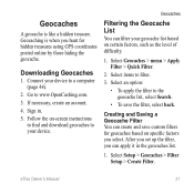
...8226; To save custom filters for hidden treasures using GPS coordinates posted online by those hiding the geocache. Select an option: • To apply the filter to www.OpenCaching.com. 3. eTrex Owner's Manual 21 Geocaching is like a hidden treasure...a computer (page 44). 2. Select Geocaches > menu > Apply Filter > Quick Filter. 2. After you set up the filter, you select.
Owner's Manual - Page 24

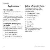
.... 4. When you are within 10 feet (3 m) of a particular location. 1. Sending and Receiving Data Wirelessly Before you can share information wirelessly. Select a location. 5. Select Share Wirelessly. 2. Setting a Proximity Alarm Proximity alarms alert you when you enter a proximity alarm area, the device sounds a tone (eTrex 20/30). 24 eTrex Owner's Manual Select Use...
Owner's Manual - Page 26

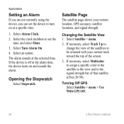
... the Satellite View 1. Applications Setting an Alarm If you are not currently using the device, you can set the time, and select Done. 3. Select the clock numbers to set the device to turn on ... 4. Satellite Page The satellite page shows your current track toward the top of that satellite (eTrex 20/30). The alarm sounds at the selected time. If necessary, select Multicolor to assign...
Owner's Manual - Page 27

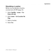
Select a location. 4. Select menu > Set Location On Map. 3. Select Satellite > menu > Use With GPS Off. 2. Applications eTrex Owner's Manual 27 Select Use. Simulating a Location Before you can simulate a location, you must turn off GPS (page 26). 1.
Owner's Manual - Page 30

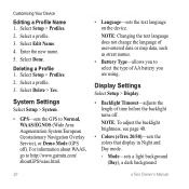
... mode. ◦◦ Mode-sets a light background (Day), a dark background 30 eTrex Owner's Manual Deleting a Profile 1. For information about WAAS, go to Normal, WAAS/EGNOS (Wide Area Augmentation System/European Geostationary Navigation Overlay Service), or Demo Mode (GPS off . Select a profile. 3. System Settings Select Setup > System. • GPS-sets the GPS to http://www.garmin.com...
Owner's Manual - Page 31

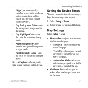
...◦◦ Track Up-shows your current location (Auto). ◦◦ Day Background Color-sets the background image used in day mode. ◦◦ Day Highlight Color-sets the color for each audible type. Select Setup > Tones. 2. sets the background image used in night mode. ...at the top. • Guidance Text-allows you to show guidance text on the map. eTrex Owner's Manual 31
Owner's Manual - Page 33

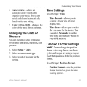
...8226; Position Format-sets the position format in which a given location reading appears. eTrex Owner's Manual 33 Select a unit of the track line on the user setting. • Color (eTrex 20/30)-changes the...Auto Archive-selects an automatic archive method to organize your GPS position. Changing the Units of measure for the setting. You can customize units of Measure You can select ...
Owner's Manual - Page 34

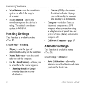
The default coordinate system is using. Heading Settings This function is available on the compass. • North Reference-sets the north reference of the compass. • Go To Line (Pointer)-allows you are traveling at a higher rate of speed for a set period of directional heading on the eTrex 30. sets the direction to your destination. ◦◦ Course...
Owner's Manual - Page 37

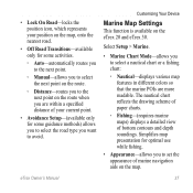
... guidance methods) allows you to select the road type you want to avoid. Simplifies map presentation for some activities. ◦◦ Auto-automatically routes you to the next point. ◦...◦◦ Distance-routes you to the next point on the eTrex 20 and eTrex 30. Customizing Your Device Marine Map Settings This function is available on the route when you are more readable....
Owner's Manual - Page 39

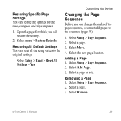
... add pages to add. Select a page. 3. Select Setup > Page Sequence. 2. Select Setup > Page Sequence. 2. Select a page. 3. eTrex Owner's Manual 39 Select Move. 4. Select Setup > Reset > Reset All Settings > Yes. Restoring Specific Page Settings You can reset all the setup values to the original settings. Open the page for the map, compass, and trip computer. 1.
Owner's Manual - Page 47

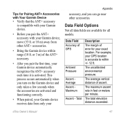
...Accuracy of ascent. The average vertical distance of GPS Ambient Pressure Ascent Average Ascent Maximum Ascent - The total elevation distance ascended. eTrex Owner's Manual 47 or 3 m) of error ...time, your GPS location is activated. For example, your Garmin device automatically recognizes the ANT+ accessory each time it is accurate to within range (10 ft. or 10 m) away ...
Owner's Manual - Page 49

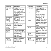
...default position format regardless of distance traveled for all trips. eTrex Owner's Manual 49 Appendix Description A running tally of the selected settings. Displays the current position in the direction of the ... Speed Moving Avg. GPS Signal Strength Heading Heart Rate (heart rate monitor required) Location (lat/lon) Location (selected) Description The glide ratio required to Dest.
Owner's Manual - Page 50

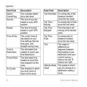
...the next waypoint on your GPS position. The estimated time needed to your destination and your GPS position. Turn The angle ... A running tally of day based on a destination along a route. 50 eTrex Owner's Manual R means turn left. L means turn right. Appendix Data ... to reach your time settings (format, time zone, and daylight saving time). Trip Time Stopped The...
Owner's Manual - Page 55

... timeout 30 screen capture 30 settings 30 downloading geocaches 21 software 40 driving routes 37 E editing profiles 30 routes 12 waypoints 9 eTrex Owner's Manual elevation plot 19...location 11 fishing times 25 fitness options 46 G geocaches 21, 35 downloading 21 filter list 21 logging attempt 22 navigating to 22 settings 35 GPS signals 8, 26, 30, 47, 49, 52 turning off 26 H heading settings...
Owner's Manual - Page 56

... GPS 26, 27 saving tracks 15 sharing data 24 Sight N' Go 10 software updating 40 version 40 stopwatch 26 storing the device 42 sunrise and sunset times 25, 50 system settings 30 T text size, maps 32 time alarms 26 data fields 50 settings 33 sunrise and sunset 25, 50 zone 33 tones 31 56 eTrex...

Similar Questions

Switching From Latitude/longitude To Grid References
my etrex20 has swtched from showing grid refs to latitude etc. how do i get back to grid references?
(Posted by bmonk34 8 years ago)
Storage Problem On Gps Etrex 10
When I try to store anything on my eTrex 10, I get this message appear on the screen. "There is not ...
(Posted by derekhill108 8 years ago)
Etrex 10 How To Set Up
(Posted by stazzyvs 10 years ago)
Grid References
Where/how do I display grid references on a garmin 20 GPS
(Posted by dkyddd 11 years ago)
Ask a New Question
Use the box below to post a new question about this Garmin product .
Points & Prizes
  • You can earn points for nearly everything you do on HelpOwl.com
  • You can trade in those points for gift cards at leading retailers such as Amazon.com and Walmart
  • It's that simple!
See How it Works
Create a Free Account

Garmin Manuals

Find free Garmin eTrex 10 manuals and user guides available at ManualOwl.com. Try out our unique manual viewer allowing you to interact with manuals from directly within your browser!

Garmin Reviews

View thousands of Garmin user reviews and customer ratings available at ReviewOwl.com.

Contact Information

Complete Garmin customer service contact information including steps to reach representatives, hours of operation, customer support links and more from ContactHelp.com.

Scoreboard Ratings

See detailed Garmin customer service rankings, employee comments and much more from our sister site.