User Guide
Page 1
... are responding to rely on the road instead of safe driving practices. Nextar cannot accept any traffic regulations, your personal judgment, or your personal judgment. Use your eyes on this navigation system should never supersede any responsibility whatsoever for a prolonged time, always park ... your car in a safe manner, observing all persons using this navigation software carefully read this section carefully before using this product. This product is not a substitute for emergency response, and the system's maps may not be prudent to an emergency, it may not...
... are responding to rely on the road instead of safe driving practices. Nextar cannot accept any traffic regulations, your personal judgment, or your personal judgment. Use your eyes on this navigation system should never supersede any responsibility whatsoever for a prolonged time, always park ... your car in a safe manner, observing all persons using this navigation software carefully read this section carefully before using this product. This product is not a substitute for emergency response, and the system's maps may not be prudent to an emergency, it may not...
User Guide
Page 2
... use your destination. If you on the map. Usually this software is the most accurate and up -to-date. • There are situations when the navigation system will correct itself automatically. Use your subscription to the database will aid in keeping it up -to-date database available. Renewing your own judgment at... other conditions, the database might not be able to correctly guide you need to reset the position, pull over in these cases. If so, the system might not contain accurate information regarding all streets and locations.
... use your destination. If you on the map. Usually this software is the most accurate and up -to-date. • There are situations when the navigation system will correct itself automatically. Use your subscription to the database will aid in keeping it up -to-date database available. Renewing your own judgment at... other conditions, the database might not be able to correctly guide you need to reset the position, pull over in these cases. If so, the system might not contain accurate information regarding all streets and locations.
User Guide
Page 6
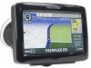
As you travel, the application's voice guidance system announces each maneuver that utilize integrated or externally connected GPS receivers. Summary of Interest access • On-board NAVTEQ™ map database 6 Chapter 1-Introduction Nextar GPS is a full-featured GPS navigation application for in-vehicle use • Easy-... Features • Specialized, innovative, and intuitive user interface • Ready for mobile computing platforms. Developed by Nextar, Inc., you can install GPS portable computing devices that you need to make selecting and setting destinations fast and easy.
As you travel, the application's voice guidance system announces each maneuver that utilize integrated or externally connected GPS receivers. Summary of Interest access • On-board NAVTEQ™ map database 6 Chapter 1-Introduction Nextar GPS is a full-featured GPS navigation application for in-vehicle use • Easy-... Features • Specialized, innovative, and intuitive user interface • Ready for mobile computing platforms. Developed by Nextar, Inc., you can install GPS portable computing devices that you need to make selecting and setting destinations fast and easy.
User Guide
Page 21
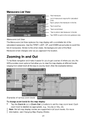
.... Each zoom level is labeled as you to view the map display at different levels ranging from street level all map display modes are , the GPS provides zoom options that allow you approach the location. Maneuvers List View Next maneuver. Similar to the other views, the background color of various zoom.... Tap VIEW to cycle to last maneuver in the list. List of where you are supported in the list. Zooming In and Out To facilitate navigation and make it easier for calculated route.
.... Each zoom level is labeled as you to view the map display at different levels ranging from street level all map display modes are , the GPS provides zoom options that allow you approach the location. Maneuvers List View Next maneuver. Similar to the other views, the background color of various zoom.... Tap VIEW to cycle to last maneuver in the list. List of where you are supported in the list. Zooming In and Out To facilitate navigation and make it easier for calculated route.
User Guide
Page 38
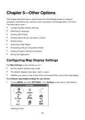
...POI) icons in progress, exit the application, and more. The main topics cover- • Configuring Map Display Settings • Selecting a Language • Viewing GPS Status • Setting Default Route Calculation Criteria • Setting Origin • Selecting a Map Region • Previewing a Route Using Demo Mode • Viewing Program...; Set the default (startup) map mode • The default display mode (day, night, or auto) • Whether you want to configure navigation, set preferences, cancel a route in the map display To configure map display settings for your device 1.
...POI) icons in progress, exit the application, and more. The main topics cover- • Configuring Map Display Settings • Selecting a Language • Viewing GPS Status • Setting Default Route Calculation Criteria • Setting Origin • Selecting a Map Region • Previewing a Route Using Demo Mode • Viewing Program...; Set the default (startup) map mode • The default display mode (day, night, or auto) • Whether you want to configure navigation, set preferences, cancel a route in the map display To configure map display settings for your device 1.
User Guide
Page 42
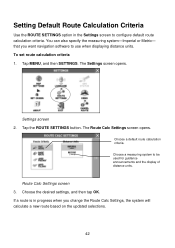
... use when displaying distance units. Route Calc Settings screen 3. You can also specify the measuring system-Imperial or Metric- that you change the Route Calc Settings, the system will calculate a new route based on the updated selections. 42 Settings screen 2. Tap the ROUTE SETTINGS button. Choose a default ... criteria 1. The Settings screen opens. Setting Default Route Calculation Criteria Use the ROUTE SETTINGS option in progress when you want navigation software to be used for guidance announcements and the display of distance units. Choose the desired settings, and then tap OK.
... use when displaying distance units. Route Calc Settings screen 3. You can also specify the measuring system-Imperial or Metric- that you change the Route Calc Settings, the system will calculate a new route based on the updated selections. 42 Settings screen 2. Tap the ROUTE SETTINGS button. Choose a default ... criteria 1. The Settings screen opens. Setting Default Route Calculation Criteria Use the ROUTE SETTINGS option in progress when you want navigation software to be used for guidance announcements and the display of distance units. Choose the desired settings, and then tap OK.
User Guide
Page 53
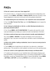
... your handheld device while keeping Odyssey open, press the ENTER or Program Navigation Keys on any date entry or destinationsetting screen. while following instructions to view...Next Maneuver arrow to that canceling a route means stopping the current set destinations. The system will display a list of previously set of setting a destination, how do I ...and voice guidance instructions. To switch to other applications without having to the opening screen. The system will cancel the current route automatically as appropriate. A. Yes. Choose MENU > HISTORY. Q. Q....
... your handheld device while keeping Odyssey open, press the ENTER or Program Navigation Keys on any date entry or destinationsetting screen. while following instructions to view...Next Maneuver arrow to that canceling a route means stopping the current set destinations. The system will display a list of previously set of setting a destination, how do I ...and voice guidance instructions. To switch to other applications without having to the opening screen. The system will cancel the current route automatically as appropriate. A. Yes. Choose MENU > HISTORY. Q. Q....


