Manual - English
Page 3
Table of Contents Information ...1 About Satellite Navigation ...1 How Satellite Navigation Works 1 Line of Sight ...1 Precision ...1 A Word on the Safe Usage of GPS Maps 2 From Source to Destination 2 GPS Maps and Your Safety 3 Magellan RoadMate ...4 Front View ...4 Rear View ...5 Cradle Front View ...6 ...6 Cradle Side View ...6 Installation ...7 Installation with the Windshield Mount 7 POI Manager ...9 Overview ...9 Latitude ...9 Longitude ...10 Altitude...
Table of Contents Information ...1 About Satellite Navigation ...1 How Satellite Navigation Works 1 Line of Sight ...1 Precision ...1 A Word on the Safe Usage of GPS Maps 2 From Source to Destination 2 GPS Maps and Your Safety 3 Magellan RoadMate ...4 Front View ...4 Rear View ...5 Cradle Front View ...6 ...6 Cradle Side View ...6 Installation ...7 Installation with the Windshield Mount 7 POI Manager ...9 Overview ...9 Latitude ...9 Longitude ...10 Altitude...
Manual - English
Page 4
... 78 Resetting the Trip Computer 78 Viewing a Saved Trip Report 78 Deleting a Trip Report ...79 Configuration ...80 POI Selection ...80 Custom POIs ...81 Map Options ...86 Select Map Color ...87 ii Previous City 54 Trip Planner - Search by State 52 Create New Entry - Table of Interest as a Destination 63 Spell Name ...63...
... 78 Resetting the Trip Computer 78 Viewing a Saved Trip Report 78 Deleting a Trip Report ...79 Configuration ...80 POI Selection ...80 Custom POIs ...81 Map Options ...86 Select Map Color ...87 ii Previous City 54 Trip Planner - Search by State 52 Create New Entry - Table of Interest as a Destination 63 Spell Name ...63...
Manual - English
Page 5
... Screen Display 111 Appendix C ...112 POI Categories ...112 Appendix D ...113 Specifications ...114 THALES CONSUMER PRODUCTS GPS RECEIVER END USER SOFTWARE LICENSE 115 THALES CONSUMER PRODUCTS PRODUCTS LIMITED WARRANTY 118 iii Table of Contents Route Preferences ...88 Detour... ...95 Diagnostics ...95 Product Information ...95 Video Test ...95 Touch Screen Test ...96 Keypad Test ...96 Set GPS Position ...97 Simulator Mode ...98 Edit User Name ...98 Map Regions ...99 Safety Lockout ...101 Password ...101 Automatic Volume ...102 Backup and Restore ...103 Restoring Information and Preferences...
... Screen Display 111 Appendix C ...112 POI Categories ...112 Appendix D ...113 Specifications ...114 THALES CONSUMER PRODUCTS GPS RECEIVER END USER SOFTWARE LICENSE 115 THALES CONSUMER PRODUCTS PRODUCTS LIMITED WARRANTY 118 iii Table of Contents Route Preferences ...88 Detour... ...95 Diagnostics ...95 Product Information ...95 Video Test ...95 Touch Screen Test ...96 Keypad Test ...96 Set GPS Position ...97 Simulator Mode ...98 Edit User Name ...98 Map Regions ...99 Safety Lockout ...101 Password ...101 Automatic Volume ...102 Backup and Restore ...103 Restoring Information and Preferences...
Manual - English
Page 6
... use of 3 meters is achieved 1 the more accurate the positioning. SBAS provides differential signal corrections for GPS and GLONASS transmissions with global-positioning satellites. By comparing the time the signals were transmitted from satellite navigation-augmentation... lightweight materials, satellite-navigation receivers will not work underground or in a vast number of a receiver in 2008, is being upgraded to pinpoint their professional and Magellan®-branded receivers. Many Thales Navigation receivers provide comprehensive mapping data, making satellite navigation ...
... use of 3 meters is achieved 1 the more accurate the positioning. SBAS provides differential signal corrections for GPS and GLONASS transmissions with global-positioning satellites. By comparing the time the signals were transmitted from satellite navigation-augmentation... lightweight materials, satellite-navigation receivers will not work underground or in a vast number of a receiver in 2008, is being upgraded to pinpoint their professional and Magellan®-branded receivers. Many Thales Navigation receivers provide comprehensive mapping data, making satellite navigation ...
Manual - English
Page 7
... together, or lined up relative to increase the accuracy of satellite navigation include the use of Magellan GPS products, is accurate to one or more detailed the map. From Source to Destination Thales Navigation, maker of DGPS (Differential Global-Positioning System); Information using...marine charts will often present only a minimal representation of roadways and are using GPS maps (just as they pass through Earth's atmosphere. Thales Navigation processes and compresses the raw data into a receiver is not as accurate as possible, data from multiple sources are monitored and ...
... together, or lined up relative to increase the accuracy of satellite navigation include the use of Magellan GPS products, is accurate to one or more detailed the map. From Source to Destination Thales Navigation, maker of DGPS (Differential Global-Positioning System); Information using...marine charts will often present only a minimal representation of roadways and are using GPS maps (just as they pass through Earth's atmosphere. Thales Navigation processes and compresses the raw data into a receiver is not as accurate as possible, data from multiple sources are monitored and ...
Manual - English
Page 8
... enforcement, emergency rescue, medical or other limits; The Magellan GPS receiver must be your responsibility to ensure compliance to all traffic laws, including pedestrian observance of our maps on our GPS devices. Disregard any of your relevant local knowledge, road...Technologies, Navionics, DMTI and C-Map. 3 Information continuously review, correct, and improve upon their map data. neighborhood quality or safety; For instance, the Magellan GPS receiver should be impassable, trees and tall buildings can obscure GPS signals, and your GPS map with a critical eye. ...
... enforcement, emergency rescue, medical or other limits; The Magellan GPS receiver must be your responsibility to ensure compliance to all traffic laws, including pedestrian observance of our maps on our GPS devices. Disregard any of your relevant local knowledge, road...Technologies, Navionics, DMTI and C-Map. 3 Information continuously review, correct, and improve upon their map data. neighborhood quality or safety; For instance, the Magellan GPS receiver should be impassable, trees and tall buildings can obscure GPS signals, and your GPS map with a critical eye. ...
Manual - English
Page 9
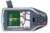
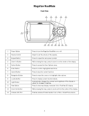
... lighting. Press to move the cursor or to display current location details. While viewing the map, press to adjust for changes in on or off. While viewing the map, press to set the volume of the display. Magellan RoadMate Magellan RoadMate Front View 2 3 4 5 6 1 1 Power Button 2 Volume Control 3 Repeat Button... 13 12 11 10 9 8 7 Press to repeat the last spoken prompt. Press to turn the Magellan RoadMate on the center of the speaker. Press to view map display, maneuver list or TrueView 3D display. Press to confirm highlighted selections. Adjust to zoom out from ...
... lighting. Press to move the cursor or to display current location details. While viewing the map, press to adjust for changes in on or off. While viewing the map, press to set the volume of the display. Magellan RoadMate Magellan RoadMate Front View 2 3 4 5 6 1 1 Power Button 2 Volume Control 3 Repeat Button... 13 12 11 10 9 8 7 Press to repeat the last spoken prompt. Press to turn the Magellan RoadMate on the center of the speaker. Press to view map display, maneuver list or TrueView 3D display. Press to confirm highlighted selections. Adjust to zoom out from ...
Manual - English
Page 14
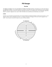
... location is below the Equator, you to add custom POIs to your Magellan RoadMate. You can be expressed by dividing Earth into horizontal segments totalling 180 degrees. The POI Manager adds POIs based on the Map screen. Starting at a South Latitude. 0° 10° 20&#...Latitude Latitude can add things such as altitude and a description are easier to the south. POI Manager POI Manager Overview The Magellan RoadMate 760 comes with Magellan RoadMate POI Manager Software. POIs are optional. Other information such as friends' houses and other favorite places that are drawn in the ...
... location is below the Equator, you to add custom POIs to your Magellan RoadMate. You can be expressed by dividing Earth into horizontal segments totalling 180 degrees. The POI Manager adds POIs based on the Map screen. Starting at a South Latitude. 0° 10° 20&#...Latitude Latitude can add things such as altitude and a description are easier to the south. POI Manager POI Manager Overview The Magellan RoadMate 760 comes with Magellan RoadMate POI Manager Software. POIs are optional. Other information such as friends' houses and other favorite places that are drawn in the ...
Manual - English
Page 28
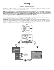
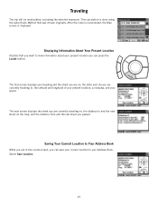
... screen is displayed. This screen displays a list of maneuvers to follow picture of your destination: the Map screen, the Maneuver List screen, and the TrueView 3D/Split TrueView screen. Traveling Traveling Guidance Information Screens The Magellan RoadMate has three screens you can use to assist you in travelling to your surrounding area along...
... screen is displayed. This screen displays a list of maneuvers to follow picture of your destination: the Map screen, the Maneuver List screen, and the TrueView 3D/Split TrueView screen. Traveling Traveling Guidance Information Screens The Magellan RoadMate has three screens you can use to assist you in travelling to your surrounding area along...
Manual - English
Page 29
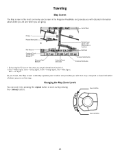
... GPS Signal Strength †† Distance to Next Maneuver Estimated Time to Destination Position Cursor (points in the direction you are traveling) Next Road Distance to Destination Direction of where you are on the screen, you can zoom in the Magellan RoadMate and provides you with not only a map... but a visual indication of Destination † By touching the POI icon on the map. Changing the Map Zoom Levels You can get information and route to it. ††...
... GPS Signal Strength †† Distance to Next Maneuver Estimated Time to Destination Position Cursor (points in the direction you are traveling) Next Road Distance to Destination Direction of where you are on the screen, you can zoom in the Magellan RoadMate and provides you with not only a map... but a visual indication of Destination † By touching the POI icon on the map. Changing the Map Zoom Levels You can get information and route to it. ††...
Manual - English
Page 30
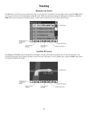
... of the next maneuver. Next Maneuver Direction of Travel and GPS Signal Strength Distance to Next Maneuver Estimated Time to Destination Distance to Destination Direction of Destination TrueView 3D Screen The Magellan RoadMate uses TrueView 3D technology to Destination Direction of Destination 25 From the Map screen, press the View button twice to the...
... of the next maneuver. Next Maneuver Direction of Travel and GPS Signal Strength Distance to Next Maneuver Estimated Time to Destination Distance to Destination Direction of Destination TrueView 3D Screen The Magellan RoadMate uses TrueView 3D technology to Destination Direction of Destination 25 From the Map screen, press the View button twice to the...

Manual - English
Page 31
... of two ways. 1. Select Exclude. 26 Next Maneuver Map with Planned Route Direction of Travel and GPS Signal Strength Distance to Next Maneuver Estimated Time to Destination Distance to avoid. If, while driving, you exit the planned route, the Magellan RoadMate will also turn off . Excluding a Maneuver in the.... 2. The details for the maneuver are displayed. If you back on your route. Press the View button to exclude. The Magellan RoadMate provides you with a screen asking whether you wish to get you exit the planned route before its completion and turn off your vehicle, ...
... of two ways. 1. Select Exclude. 26 Next Maneuver Map with Planned Route Direction of Travel and GPS Signal Strength Distance to Next Maneuver Estimated Time to Destination Distance to avoid. If, while driving, you exit the planned route, the Magellan RoadMate will also turn off . Excluding a Maneuver in the.... 2. The details for the maneuver are displayed. If you back on your route. Press the View button to exclude. The Magellan RoadMate provides you with a screen asking whether you wish to get you exit the planned route before its completion and turn off your vehicle, ...
Manual - English
Page 32
... heading and the street you are on, the state and city you are currently traveling on, the distance to and the next street on the map, and the distance from and the last street you are currently traveling in the Locate screen, you can save your current location to your Address... Book. After the route is recalculated, the Map screen is done using the same Route Method that you want to Your Address Book While you are in , the latitude and longitude of your...
... heading and the street you are on, the state and city you are currently traveling on, the distance to and the next street on the map, and the distance from and the last street you are currently traveling in the Locate screen, you can save your current location to your Address... Book. After the route is recalculated, the Map screen is done using the same Route Method that you want to Your Address Book While you are in , the latitude and longitude of your...
Manual - English
Page 37
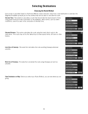
... the route. Least Use of shortest time. Selecting Destinations Choosing the Route Method Every route is selected, the Magellan RoadMate prompts you are going. 32 Every time a new destination is calculated based on Map: Before you select your Route Method, you can see where you for the method that should take the least...
... the route. Least Use of shortest time. Selecting Destinations Choosing the Route Method Every route is selected, the Magellan RoadMate prompts you are going. 32 Every time a new destination is calculated based on Map: Before you select your Route Method, you can see where you for the method that should take the least...
Manual - English
Page 38
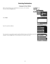
The route will be re-calculated using the new Route Method chosen and the Map screen will be displayed. Press the View button to see the Maneuver List with the new route. 33 Select Route. Select the new Route Method. Selecting Destinations Changing the Route Method While viewing the Map screen, the Maneuver List screen, or the TrueView 3D screen, press the Cancel button.
The route will be re-calculated using the new Route Method chosen and the Map screen will be displayed. Press the View button to see the Maneuver List with the new route. 33 Select Route. Select the new Route Method. Selecting Destinations Changing the Route Method While viewing the Map screen, the Maneuver List screen, or the TrueView 3D screen, press the Cancel button.

Manual - English
Page 39
Selecting Destinations Cancelling a Planned Route While viewing the Map screen, the Maneuver List screen, or the TrueView 3D screen, press the Cancel button. Select Yes to the last viewed screen. 34 Select No returns the display to cancel the route and display the Select Destination screen.
Selecting Destinations Cancelling a Planned Route While viewing the Map screen, the Maneuver List screen, or the TrueView 3D screen, press the Cancel button. Select Yes to the last viewed screen. 34 Select No returns the display to cancel the route and display the Select Destination screen.
Manual - English
Page 41
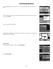
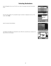
Selecting Destinations Use the Navigation key to scroll the list up or down (if necessary) and select the desired street. Select Done. Select the desired Route Method. Search By State From the Select Destination screen, select Street Address. When the calculations are complete, the Map screen will calculate the route. The acceptable range of numbers is displayed at the top of the screen. The Magellan RoadMate will be displayed. Enter the street address. Select Search By State. 36
Selecting Destinations Use the Navigation key to scroll the list up or down (if necessary) and select the desired street. Select Done. Select the desired Route Method. Search By State From the Select Destination screen, select Street Address. When the calculations are complete, the Map screen will calculate the route. The acceptable range of numbers is displayed at the top of the screen. The Magellan RoadMate will be displayed. Enter the street address. Select Search By State. 36
Manual - English
Page 43
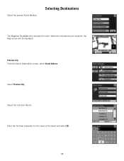
Select Previous City. Enter the first few characters for the name of the street and select OK. 38 Previous City From the Select Destination screen, select Street Address. Selecting Destinations The Magellan RoadMate will be displayed. When the calculations are complete, the Map screen will calculate the route. Select the city from the list. Select the desired Route Method.
Select Previous City. Enter the first few characters for the name of the street and select OK. 38 Previous City From the Select Destination screen, select Street Address. Selecting Destinations The Magellan RoadMate will be displayed. When the calculations are complete, the Map screen will calculate the route. Select the city from the list. Select the desired Route Method.
Manual - English
Page 44
Select the desired Route Method. Select Done. Selecting Destinations Use the Navigation key to scroll the list up or down (if necessary) and select the desired street. The Magellan RoadMate will be displayed. 39 Enter the street address. The acceptable range of numbers is displayed at the top of the screen. When the calculations are complete, the Map screen will calculate the route.
Select the desired Route Method. Select Done. Selecting Destinations Use the Navigation key to scroll the list up or down (if necessary) and select the desired street. The Magellan RoadMate will be displayed. 39 Enter the street address. The acceptable range of numbers is displayed at the top of the screen. When the calculations are complete, the Map screen will calculate the route.
Manual - English
Page 46
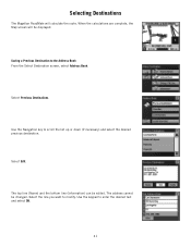
... the desired text and select OK. 41 Use the keypad to the Address Book From the Select Destination screen, select Address Book. Selecting Destinations The Magellan RoadMate will be displayed. Select Previous Destinations. Select the line you want to scroll the list up or down (if necessary) and select the desired previous.... The address cannot be edited. The top line (Name) and the bottom line (Information) can be changed. Select Edit. When the calculations are complete, the Map screen will calculate the route. Use the Navigation key to modify.
... the desired text and select OK. 41 Use the keypad to the Address Book From the Select Destination screen, select Address Book. Selecting Destinations The Magellan RoadMate will be displayed. Select Previous Destinations. Select the line you want to scroll the list up or down (if necessary) and select the desired previous.... The address cannot be edited. The top line (Name) and the bottom line (Information) can be changed. Select Edit. When the calculations are complete, the Map screen will calculate the route. Use the Navigation key to modify.


