Manual - English
Page 3
Table of Contents Information ...1 About Satellite Navigation ...1 How Satellite Navigation Works 1 Line of Sight ...1 Precision ...1 A Word on the Safe Usage of GPS Maps 2 From Source to Destination 2 GPS Maps and Your Safety 3 Magellan RoadMate ...4 Front View ...4 Rear View ...5 Cradle Front View ...6 ...6 Cradle Side View ...6 Installation ...7 Installation with the Windshield Mount 7 POI Manager ...9 Overview ...9 Latitude ...9 Longitude ...10 Altitude...
Table of Contents Information ...1 About Satellite Navigation ...1 How Satellite Navigation Works 1 Line of Sight ...1 Precision ...1 A Word on the Safe Usage of GPS Maps 2 From Source to Destination 2 GPS Maps and Your Safety 3 Magellan RoadMate ...4 Front View ...4 Rear View ...5 Cradle Front View ...6 ...6 Cradle Side View ...6 Installation ...7 Installation with the Windshield Mount 7 POI Manager ...9 Overview ...9 Latitude ...9 Longitude ...10 Altitude...
Manual - English
Page 4
... Trip Report 78 Resetting the Trip Computer 78 Viewing a Saved Trip Report 78 Deleting a Trip Report ...79 Configuration ...80 POI Selection ...80 Custom POIs ...81 Map Options ...86 Select Map Color ...87 ii Search by State 52 Create New Entry - Search by City 50 Create New Entry - Previous City 54 Trip Planner -
... Trip Report 78 Resetting the Trip Computer 78 Viewing a Saved Trip Report 78 Deleting a Trip Report ...79 Configuration ...80 POI Selection ...80 Custom POIs ...81 Map Options ...86 Select Map Color ...87 ii Search by State 52 Create New Entry - Search by City 50 Create New Entry - Previous City 54 Trip Planner -
Manual - English
Page 5
... Screen Display 111 Appendix C ...112 POI Categories ...112 Appendix D ...113 Specifications ...114 THALES CONSUMER PRODUCTS GPS RECEIVER END USER SOFTWARE LICENSE 115 THALES CONSUMER PRODUCTS PRODUCTS LIMITED WARRANTY 118 iii Table of Contents Route Preferences ...88 Detour... ...95 Diagnostics ...95 Product Information ...95 Video Test ...95 Touch Screen Test ...96 Keypad Test ...96 Set GPS Position ...97 Simulator Mode ...98 Edit User Name ...98 Map Regions ...99 Safety Lockout ...101 Password ...101 Automatic Volume ...102 Backup and Restore ...103 Restoring Information and Preferences...
... Screen Display 111 Appendix C ...112 POI Categories ...112 Appendix D ...113 Specifications ...114 THALES CONSUMER PRODUCTS GPS RECEIVER END USER SOFTWARE LICENSE 115 THALES CONSUMER PRODUCTS PRODUCTS LIMITED WARRANTY 118 iii Table of Contents Route Preferences ...88 Detour... ...95 Diagnostics ...95 Product Information ...95 Video Test ...95 Touch Screen Test ...96 Keypad Test ...96 Set GPS Position ...97 Simulator Mode ...98 Edit User Name ...98 Map Regions ...99 Safety Lockout ...101 Password ...101 Automatic Volume ...102 Backup and Restore ...103 Restoring Information and Preferences...
Manual - English
Page 6
... augmentation systems. While the GPS and GLONASS satellite networks are continuously within 15 meters. the more . It adds a new level of enjoyment and safety to a wide range of a receiver in order to pinpoint their professional and Magellan®-branded receivers. A Global Navigation Satellite ... transmitted from three or more accurate the positioning. Precision On average, a satellite-navigation receiver is accurate to increase the accuracy of every position on an electronic map. An accuracy of 3 meters or better is achieved using correction signals from satellite navigation...
... augmentation systems. While the GPS and GLONASS satellite networks are continuously within 15 meters. the more . It adds a new level of enjoyment and safety to a wide range of a receiver in order to pinpoint their professional and Magellan®-branded receivers. A Global Navigation Satellite ... transmitted from three or more accurate the positioning. Precision On average, a satellite-navigation receiver is accurate to increase the accuracy of every position on an electronic map. An accuracy of 3 meters or better is achieved using correction signals from satellite navigation...
Manual - English
Page 7
...Satellite-navigation signals slow as WAAS (Wide-Area Augmentation System). Multipath signals -- Thales Navigation processes and compresses the raw data into a receiver is not as accurate as possible, data from multiple sources are using in a number of ways: Orbiting errors -- Throughout Europe a... from the best public and private sources available at known positions, transmit corrected satellite-navigation signals. Maps also vary widely in terms of Magellan GPS products, is designed for triangulating a position become difficult and less reliable. We seek to within a few...
...Satellite-navigation signals slow as WAAS (Wide-Area Augmentation System). Multipath signals -- Thales Navigation processes and compresses the raw data into a receiver is not as accurate as possible, data from multiple sources are using in a number of ways: Orbiting errors -- Throughout Europe a... from the best public and private sources available at known positions, transmit corrected satellite-navigation signals. Maps also vary widely in terms of Magellan GPS products, is designed for triangulating a position become difficult and less reliable. We seek to within a few...
Manual - English
Page 8
... user's full attention to a complete stop. The Magellan GPS receiver must be used with a critical eye. For instance, the Magellan GPS receiver should be impassable, trees and tall buildings can obscure GPS signals, and your primary concern. Magellan maps do not include, analyze, process, consider or reflect...sense, and it is an aid to use good judgment while operating the Magellan GPS receiver. bridge height, width, weight or other assistance; availability or proximity of our maps on our GPS devices. We release new versions of law enforcement, emergency rescue, medical ...
... user's full attention to a complete stop. The Magellan GPS receiver must be used with a critical eye. For instance, the Magellan GPS receiver should be impassable, trees and tall buildings can obscure GPS signals, and your primary concern. Magellan maps do not include, analyze, process, consider or reflect...sense, and it is an aid to use good judgment while operating the Magellan GPS receiver. bridge height, width, weight or other assistance; availability or proximity of our maps on our GPS devices. We release new versions of law enforcement, emergency rescue, medical ...
Manual - English
Page 9
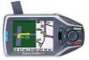
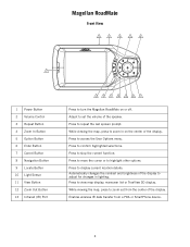
... selections. Press to access the User Options menu. Press to turn the Magellan RoadMate on the center of the speaker. Magellan RoadMate Magellan RoadMate Front View 2 3 4 5 6 1 1 Power Button 2 Volume Control... 3 Repeat Button 4 Zoom In Button 5 Option Button 6 Enter Button 7 Cancel Button 8 Navigation Button 9 Locate Button 10 Light Sensor 11 View Button 12 Zoom Out Button 13 Infrared (IR) Port 13 12 11 10 9 8 7 Press to stop the current function. While viewing the map...
... selections. Press to access the User Options menu. Press to turn the Magellan RoadMate on the center of the speaker. Magellan RoadMate Magellan RoadMate Front View 2 3 4 5 6 1 1 Power Button 2 Volume Control... 3 Repeat Button 4 Zoom In Button 5 Option Button 6 Enter Button 7 Cancel Button 8 Navigation Button 9 Locate Button 10 Light Sensor 11 View Button 12 Zoom Out Button 13 Infrared (IR) Port 13 12 11 10 9 8 7 Press to stop the current function. While viewing the map...
Manual - English
Page 14
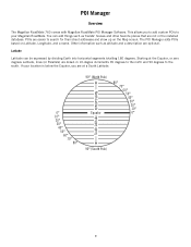
... Equator, you to add custom POIs to search for than street addresses and show up on Latitude, Longitude, and a name. POIs are optional. If your Magellan RoadMate. You can be expressed by dividing Earth into horizontal segments totalling 180 degrees. Starting at a South Latitude. 0° 10° 20° 30° ...; 60° 50° 40° 30° 20° 10° 0° South Latitude 90° (South Pole) 9 POI Manager POI Manager Overview The Magellan RoadMate 760 comes with Magellan RoadMate POI Manager Software. The POI Manager adds POIs based on the Map screen.
... Equator, you to add custom POIs to search for than street addresses and show up on Latitude, Longitude, and a name. POIs are optional. If your Magellan RoadMate. You can be expressed by dividing Earth into horizontal segments totalling 180 degrees. Starting at a South Latitude. 0° 10° 20° 30° ...; 60° 50° 40° 30° 20° 10° 0° South Latitude 90° (South Pole) 9 POI Manager POI Manager Overview The Magellan RoadMate 760 comes with Magellan RoadMate POI Manager Software. The POI Manager adds POIs based on the Map screen.
Manual - English
Page 28
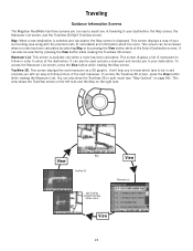
...view shows the TrueView screen on the left side and the Map on page 86). Traveling Traveling Guidance Information Screens The Magellan RoadMate has three screens you can be accessed when no route has been calculated by selecting Map or by pressing the View button while viewing the TrueView 3D... and reroute you with the planned route (if calculated) and information about the route. Maneuver List: This screen is displayed. Map TrueView 3D Split TrueView (enabled from Map Options menu) Maneuver List View 23 To access the Maneuver List screen, press the View button while viewing the...
...view shows the TrueView screen on the left side and the Map on page 86). Traveling Traveling Guidance Information Screens The Magellan RoadMate has three screens you can be accessed when no route has been calculated by selecting Map or by pressing the View button while viewing the TrueView 3D... and reroute you with the planned route (if calculated) and information about the route. Maneuver List: This screen is displayed. Map TrueView 3D Split TrueView (enabled from Map Options menu) Maneuver List View 23 To access the Maneuver List screen, press the View button while viewing the...
Manual - English
Page 29
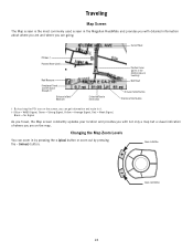
...GPS Signal Strength †† Distance to Next Maneuver Estimated Time to Destination Position Cursor (points in the direction you are traveling) Next Road Distance to it. †† Blue = WASS Signal, Green = Strong Signal, Yellow = Average Signal, Red = Weak Signal, Black = No Signal As you travel, the Map... screen constantly updates your location and provides you with detailed information about where you are and where you are on the screen, you can zoom in the Magellan RoadMate and provides you with not only a map but a visual indication of ...
...GPS Signal Strength †† Distance to Next Maneuver Estimated Time to Destination Position Cursor (points in the direction you are traveling) Next Road Distance to it. †† Blue = WASS Signal, Green = Strong Signal, Yellow = Average Signal, Red = Weak Signal, Black = No Signal As you travel, the Map... screen constantly updates your location and provides you with detailed information about where you are and where you are on the screen, you can zoom in the Magellan RoadMate and provides you with not only a map but a visual indication of ...
Manual - English
Page 30
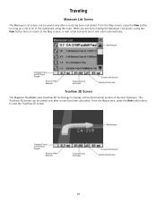
... all of Destination TrueView 3D Screen The Magellan RoadMate uses TrueView 3D technology to view the TrueView 3D screen. The TrueView 3D screen can be viewed only after a route has been calculated. Next Maneuver Direction of Travel and GPS Signal Strength Distance to Next Maneuver Estimated ...to Destination Direction of the maneuvers along the route. From the Map screen, press the View button twice to display a three-dimensional picture of Destination 25 Next Maneuver Direction of Travel and GPS Signal Strength Distance to Next Maneuver Estimated Time to Destination Distance ...
... all of Destination TrueView 3D Screen The Magellan RoadMate uses TrueView 3D technology to view the TrueView 3D screen. The TrueView 3D screen can be viewed only after a route has been calculated. Next Maneuver Direction of Travel and GPS Signal Strength Distance to Next Maneuver Estimated ...to Destination Direction of the maneuvers along the route. From the Map screen, press the View button twice to display a three-dimensional picture of Destination 25 Next Maneuver Direction of Travel and GPS Signal Strength Distance to Next Maneuver Estimated Time to Destination Distance ...

Manual - English
Page 31
...your new location. Traveling In split mode, the left half of the screen shows TrueView 3D, while the right half of Travel and GPS Signal Strength Distance to Next Maneuver Estimated Time to Destination Distance to avoid. Select Resume to continue the route to the Maneuver List. ... resume your vehicle back on, the Magellan RoadMate will also turn off your vehicle, the Magellan RoadMate will turn your route. This could be due to an accident or street maintenance you with Planned Route Direction of the screen shows the Map. Next Maneuver Map with tools to clear the route and...
...your new location. Traveling In split mode, the left half of the screen shows TrueView 3D, while the right half of Travel and GPS Signal Strength Distance to Next Maneuver Estimated Time to Destination Distance to avoid. Select Resume to continue the route to the Maneuver List. ... resume your vehicle back on, the Magellan RoadMate will also turn off your vehicle, the Magellan RoadMate will turn your route. This could be due to an accident or street maintenance you with Planned Route Direction of the screen shows the Map. Next Maneuver Map with tools to clear the route and...
Manual - English
Page 32
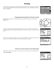
... last street you can press the Locate button. Displaying Information About Your Present Location Anytime that was chosen originally. After the route is recalculated, the Map screen is done using the same Route Method that you can save your current location to view information about your speed. Saving Your Current Location...
... last street you can press the Locate button. Displaying Information About Your Present Location Anytime that was chosen originally. After the route is recalculated, the Map screen is done using the same Route Method that you can save your current location to view information about your speed. Saving Your Current Location...
Manual - English
Page 37
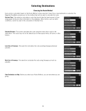
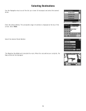
Every time a new destination is calculated based on Map: Before you select your Route Method, you can see where you for the method that should take the least amount of time using speed limits ...: This selection calculates a route that will be the fastest due to calculate the route. Selecting Destinations Choosing the Route Method Every route is selected, the Magellan RoadMate prompts you are going. 32 Least Use of Freeways: This selection calculates the route avoiding freeways whenever possible.
Every time a new destination is calculated based on Map: Before you select your Route Method, you can see where you for the method that should take the least amount of time using speed limits ...: This selection calculates a route that will be the fastest due to calculate the route. Selecting Destinations Choosing the Route Method Every route is selected, the Magellan RoadMate prompts you are going. 32 Least Use of Freeways: This selection calculates the route avoiding freeways whenever possible.
Manual - English
Page 38
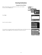
Press the View button to see the Maneuver List with the new route. 33 The route will be re-calculated using the new Route Method chosen and the Map screen will be displayed. Selecting Destinations Changing the Route Method While viewing the Map screen, the Maneuver List screen, or the TrueView 3D screen, press the Cancel button. Select Route. Select the new Route Method.
Press the View button to see the Maneuver List with the new route. 33 The route will be re-calculated using the new Route Method chosen and the Map screen will be displayed. Selecting Destinations Changing the Route Method While viewing the Map screen, the Maneuver List screen, or the TrueView 3D screen, press the Cancel button. Select Route. Select the new Route Method.

Manual - English
Page 39
Select No returns the display to cancel the route and display the Select Destination screen. Select Yes to the last viewed screen. 34 Selecting Destinations Cancelling a Planned Route While viewing the Map screen, the Maneuver List screen, or the TrueView 3D screen, press the Cancel button.
Select No returns the display to cancel the route and display the Select Destination screen. Select Yes to the last viewed screen. 34 Selecting Destinations Cancelling a Planned Route While viewing the Map screen, the Maneuver List screen, or the TrueView 3D screen, press the Cancel button.
Manual - English
Page 41
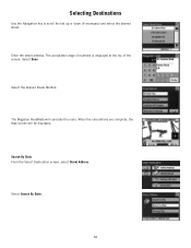
Selecting Destinations Use the Navigation key to scroll the list up or down (if necessary) and select the desired street. Select Done. Search By State From the Select Destination screen, select Street Address. Enter the street address. Select the desired Route Method. When the calculations are complete, the Map screen will calculate the route. Select Search By State. 36 The Magellan RoadMate will be displayed. The acceptable range of numbers is displayed at the top of the screen.
Selecting Destinations Use the Navigation key to scroll the list up or down (if necessary) and select the desired street. Select Done. Search By State From the Select Destination screen, select Street Address. Enter the street address. Select the desired Route Method. When the calculations are complete, the Map screen will calculate the route. Select Search By State. 36 The Magellan RoadMate will be displayed. The acceptable range of numbers is displayed at the top of the screen.
Manual - English
Page 43
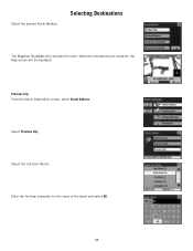
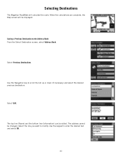
Select the desired Route Method. Selecting Destinations The Magellan RoadMate will be displayed. Previous City From the Select Destination screen, select Street Address. Enter the first few characters for the name of the street and select OK. 38 When the calculations are complete, the Map screen will calculate the route. Select the city from the list. Select Previous City.
Select the desired Route Method. Selecting Destinations The Magellan RoadMate will be displayed. Previous City From the Select Destination screen, select Street Address. Enter the first few characters for the name of the street and select OK. 38 When the calculations are complete, the Map screen will calculate the route. Select the city from the list. Select Previous City.
Manual - English
Page 44
The acceptable range of numbers is displayed at the top of the screen. The Magellan RoadMate will be displayed. 39 When the calculations are complete, the Map screen will calculate the route. Select Done. Enter the street address. Select the desired Route Method. Selecting Destinations Use the Navigation key to scroll the list up or down (if necessary) and select the desired street.
The acceptable range of numbers is displayed at the top of the screen. The Magellan RoadMate will be displayed. 39 When the calculations are complete, the Map screen will calculate the route. Select Done. Enter the street address. Select the desired Route Method. Selecting Destinations Use the Navigation key to scroll the list up or down (if necessary) and select the desired street.
Manual - English
Page 46
Selecting Destinations The Magellan RoadMate will be edited. Select the line you want to enter the desired text and select OK. 41 When the calculations are complete, the Map screen will calculate the route. Use the keypad to modify. Select Edit. The top line (Name) and the bottom line (Information) can be displayed. Saving...
Selecting Destinations The Magellan RoadMate will be edited. Select the line you want to enter the desired text and select OK. 41 When the calculations are complete, the Map screen will calculate the route. Use the keypad to modify. Select Edit. The top line (Name) and the bottom line (Information) can be displayed. Saving...


