Manual - English
Page 3
Table of Contents Information ...1 About Satellite Navigation ...1 How Satellite Navigation Works 1 Line of Sight ...1 Precision ...1 A Word on the Safe Usage of GPS Maps 2 From Source to Destination 2 GPS Maps and Your Safety 3 Magellan RoadMate ...4 Front View ...4 Rear View ...5 Cradle Front View ...6 ...6 Cradle Side View ...6 Installation ...7 Installation with the Windshield Mount 7 POI Manager ...9 Overview ...9 Latitude ...9 Longitude ...10 Altitude...
Table of Contents Information ...1 About Satellite Navigation ...1 How Satellite Navigation Works 1 Line of Sight ...1 Precision ...1 A Word on the Safe Usage of GPS Maps 2 From Source to Destination 2 GPS Maps and Your Safety 3 Magellan RoadMate ...4 Front View ...4 Rear View ...5 Cradle Front View ...6 ...6 Cradle Side View ...6 Installation ...7 Installation with the Windshield Mount 7 POI Manager ...9 Overview ...9 Latitude ...9 Longitude ...10 Altitude...
Manual - English
Page 4
... Report 78 Resetting the Trip Computer 78 Viewing a Saved Trip Report 78 Deleting a Trip Report ...79 Configuration ...80 POI Selection ...80 Custom POIs ...81 Map Options ...86 Select Map Color ...87 ii Optimizing a Trip 57 Trip Planner - Edit ...59 Trip Planner - Delete and Rename 60 Selecting a Point of Contents Selecting Destinations ...31...
... Report 78 Resetting the Trip Computer 78 Viewing a Saved Trip Report 78 Deleting a Trip Report ...79 Configuration ...80 POI Selection ...80 Custom POIs ...81 Map Options ...86 Select Map Color ...87 ii Optimizing a Trip 57 Trip Planner - Edit ...59 Trip Planner - Delete and Rename 60 Selecting a Point of Contents Selecting Destinations ...31...
Manual - English
Page 5
... Screen Display 111 Appendix C ...112 POI Categories ...112 Appendix D ...113 Specifications ...114 THALES CONSUMER PRODUCTS GPS RECEIVER END USER SOFTWARE LICENSE 115 THALES CONSUMER PRODUCTS PRODUCTS LIMITED WARRANTY 118 iii Table of Contents Route Preferences ...88 Detour... ...95 Diagnostics ...95 Product Information ...95 Video Test ...95 Touch Screen Test ...96 Keypad Test ...96 Set GPS Position ...97 Simulator Mode ...98 Edit User Name ...98 Map Regions ...99 Safety Lockout ...101 Password ...101 Automatic Volume ...102 Backup and Restore ...103 Restoring Information and Preferences...
... Screen Display 111 Appendix C ...112 POI Categories ...112 Appendix D ...113 Specifications ...114 THALES CONSUMER PRODUCTS GPS RECEIVER END USER SOFTWARE LICENSE 115 THALES CONSUMER PRODUCTS PRODUCTS LIMITED WARRANTY 118 iii Table of Contents Route Preferences ...88 Detour... ...95 Diagnostics ...95 Product Information ...95 Video Test ...95 Touch Screen Test ...96 Keypad Test ...96 Set GPS Position ...97 Simulator Mode ...98 Edit User Name ...98 Map Regions ...99 Safety Lockout ...101 Password ...101 Automatic Volume ...102 Backup and Restore ...103 Restoring Information and Preferences...
Manual - English
Page 6
... navigation satellites will pass through triangulation. With these distance measurements, the receiver might also calculate speed, bearing, trip time, distance to pinpoint their professional and Magellan®-branded receivers. This means that can be picked up by air, land and ...on Earth; Navigation satellite receivers use of navigation, sports, and recreational activities. Many Thales Navigation receivers provide comprehensive mapping data, making satellite navigation an easy tool to a wide range of additional augmentation systems. While the GPS and GLONASS satellite networks ...
... navigation satellites will pass through triangulation. With these distance measurements, the receiver might also calculate speed, bearing, trip time, distance to pinpoint their professional and Magellan®-branded receivers. This means that can be picked up by air, land and ...on Earth; Navigation satellite receivers use of navigation, sports, and recreational activities. Many Thales Navigation receivers provide comprehensive mapping data, making satellite navigation an easy tool to a wide range of additional augmentation systems. While the GPS and GLONASS satellite networks ...
Manual - English
Page 7
... From Source to Destination Thales Navigation, maker of a receiver are used to compensate. This is accurate to use of ways: Orbiting errors -- If all of the satellites within line of sight of Magellan GPS products, is not as accurate as they pass through ...to effectively compensate for other obstructions before reaching the receiver, increasing the distance a signal travels and reducing accuracy. The use of differential-correction signals from a network of GPS Maps Just like paper maps, maps on our GPS devices. We do not contain marine navigational markers....
... From Source to Destination Thales Navigation, maker of a receiver are used to compensate. This is accurate to use of ways: Orbiting errors -- If all of the satellites within line of sight of Magellan GPS products, is not as accurate as they pass through ...to effectively compensate for other obstructions before reaching the receiver, increasing the distance a signal travels and reducing accuracy. The use of differential-correction signals from a network of GPS Maps Just like paper maps, maps on our GPS devices. We do not contain marine navigational markers....
Manual - English
Page 8
... to get customer feedback prior to navigation. The Magellan GPS receiver must be used while engaged in any unsafe, hazardous or illegal route suggestions. population density; GPS Maps and Your Safety Remember, your GPS device is an aid to release. Landscapes and roads... a regular basis to use good judgment while operating the Magellan GPS receiver. pavement characteristics or conditions; bridge height, width, weight or other assistance; Information continuously review, correct, and improve upon their map data. It must not be your relevant local knowledge, road...
... to get customer feedback prior to navigation. The Magellan GPS receiver must be used while engaged in any unsafe, hazardous or illegal route suggestions. population density; GPS Maps and Your Safety Remember, your GPS device is an aid to release. Landscapes and roads... a regular basis to use good judgment while operating the Magellan GPS receiver. pavement characteristics or conditions; bridge height, width, weight or other assistance; Information continuously review, correct, and improve upon their map data. It must not be your relevant local knowledge, road...
Manual - English
Page 9
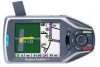
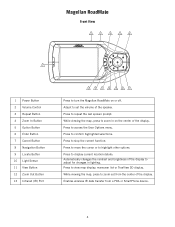
... to zoom in lighting. While viewing the map, press to zoom out from a PDA or SmartPhone device. 4 Press to display current location details. Enables wireless IR data transfer from the center of the ... prompt. Press to access the User Options menu. Automatically changes the contrast and brightness of the display to adjust for changes in on or off. Magellan RoadMate Magellan RoadMate Front View 2 3 4 5 6 1 1 Power Button 2 Volume Control 3 Repeat Button 4 Zoom In Button 5 Option Button 6 Enter Button 7 Cancel Button 8 Navigation Button 9 Locate Button 10 Light Sensor 11...
... to zoom in lighting. While viewing the map, press to zoom out from a PDA or SmartPhone device. 4 Press to display current location details. Enables wireless IR data transfer from the center of the ... prompt. Press to access the User Options menu. Automatically changes the contrast and brightness of the display to adjust for changes in on or off. Magellan RoadMate Magellan RoadMate Front View 2 3 4 5 6 1 1 Power Button 2 Volume Control 3 Repeat Button 4 Zoom In Button 5 Option Button 6 Enter Button 7 Cancel Button 8 Navigation Button 9 Locate Button 10 Light Sensor 11...
Manual - English
Page 14
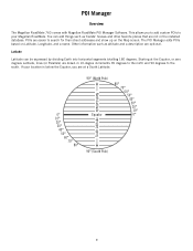
The POI Manager adds POIs based on the Map screen. You can be expressed by dividing Earth into horizontal segments totalling 180 degrees. If your location is below the Equator, you to add custom POIs to your Magellan RoadMate. POIs are not in 10-degree increments 90 degrees ... can add things such as altitude and a description are drawn in the installed database. POI Manager POI Manager Overview The Magellan RoadMate 760 comes with Magellan RoadMate POI Manager Software. This allows you are at the Equator, or zero degrees Latitude, lines (or Parallels) are optional.
The POI Manager adds POIs based on the Map screen. You can be expressed by dividing Earth into horizontal segments totalling 180 degrees. If your location is below the Equator, you to add custom POIs to your Magellan RoadMate. POIs are not in 10-degree increments 90 degrees ... can add things such as altitude and a description are drawn in the installed database. POI Manager POI Manager Overview The Magellan RoadMate 760 comes with Magellan RoadMate POI Manager Software. This allows you are at the Equator, or zero degrees Latitude, lines (or Parallels) are optional.
Manual - English
Page 28
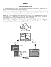
...displays the next maneuver as a 3D graphic. This view shows the TrueView screen on the left side and the Map on page 86). Map TrueView 3D Split TrueView (enabled from Map Options menu) Maneuver List View 23 This screen can be used exclude a maneuver and reroute you to your destination... route has been calculated by selecting Map or by pressing the View button while viewing the TrueView 3D screen. To access the TrueView 3D screen, press the View button while viewing the Maneuver List. Traveling Traveling Guidance Information Screens The Magellan RoadMate has three screens you can use ...
...displays the next maneuver as a 3D graphic. This view shows the TrueView screen on the left side and the Map on page 86). Map TrueView 3D Split TrueView (enabled from Map Options menu) Maneuver List View 23 This screen can be used exclude a maneuver and reroute you to your destination... route has been calculated by selecting Map or by pressing the View button while viewing the TrueView 3D screen. To access the TrueView 3D screen, press the View button while viewing the Maneuver List. Traveling Traveling Guidance Information Screens The Magellan RoadMate has three screens you can use ...
Manual - English
Page 29
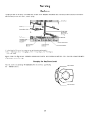
Current Road POI Icon † Planned Route (pink) Next Maneuver Direction of Travel and GPS Signal Strength †† Distance to Next Maneuver Estimated Time to Destination Position Cursor (points in by pressing the + (plus) button or zoom out by ... = No Signal As you travel, the Map screen constantly updates your location and provides you with detailed information about where you are and where you are going. Traveling Map Screen The Map screen is the most commonly used screen in the Magellan RoadMate and provides you with not only a map but a visual indication of where you...
Current Road POI Icon † Planned Route (pink) Next Maneuver Direction of Travel and GPS Signal Strength †† Distance to Next Maneuver Estimated Time to Destination Position Cursor (points in by pressing the + (plus) button or zoom out by ... = No Signal As you travel, the Map screen constantly updates your location and provides you with detailed information about where you are and where you are going. Traveling Map Screen The Map screen is the most commonly used screen in the Magellan RoadMate and provides you with not only a map but a visual indication of where you...
Manual - English
Page 30
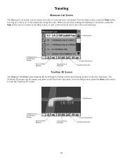
... been calculated. Next Maneuver Direction of Travel and GPS Signal Strength Distance to Next Maneuver Estimated Time to Destination Distance to Destination Direction of Destination TrueView 3D Screen The Magellan RoadMate uses TrueView 3D technology to the Map screen, or wait a few moments and it ...will return automatically. Next Maneuver Direction of Travel and GPS Signal Strength Distance to Next Maneuver Estimated Time to ...
... been calculated. Next Maneuver Direction of Travel and GPS Signal Strength Distance to Next Maneuver Estimated Time to Destination Distance to Destination Direction of Destination TrueView 3D Screen The Magellan RoadMate uses TrueView 3D technology to the Map screen, or wait a few moments and it ...will return automatically. Next Maneuver Direction of Travel and GPS Signal Strength Distance to Next Maneuver Estimated Time to ...

Manual - English
Page 31
... it necessary to the Maneuver List. The Magellan RoadMate provides you exit the planned route, the Magellan RoadMate will automatically recalculate the route based on your vehicle, the Magellan RoadMate will also turn on course in one of the screen shows the Map. Press the View button to Destination Direction ...of two ways. 1. If, while driving, you with Planned Route Direction of Travel and GPS Signal Strength Distance to ...
... it necessary to the Maneuver List. The Magellan RoadMate provides you exit the planned route, the Magellan RoadMate will automatically recalculate the route based on your vehicle, the Magellan RoadMate will also turn on course in one of the screen shows the Map. Press the View button to Destination Direction ...of two ways. 1. If, while driving, you with Planned Route Direction of Travel and GPS Signal Strength Distance to ...
Manual - English
Page 32
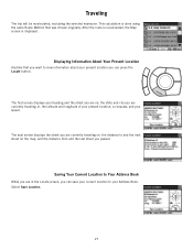
... and city you are currently traveling in the Locate screen, you are currently traveling on, the distance to and the next street on the map, and the distance from and the last street you can save your current location to your Address Book. Saving Your Current Location to view ... that was chosen originally. Select Save Location. 27 Traveling The trip will be recalculated, excluding the selected maneuver. After the route is recalculated, the Map screen is done using the same Route Method that you want to Your Address Book While you can press the Locate button. The next screen...
... and city you are currently traveling in the Locate screen, you are currently traveling on, the distance to and the next street on the map, and the distance from and the last street you can save your current location to your Address Book. Saving Your Current Location to view ... that was chosen originally. Select Save Location. 27 Traveling The trip will be recalculated, excluding the selected maneuver. After the route is recalculated, the Map screen is done using the same Route Method that you want to Your Address Book While you can press the Locate button. The next screen...
Manual - English
Page 37
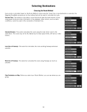
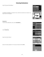
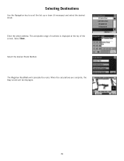
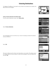
... due to the destination. Selecting Destinations Choosing the Route Method Every route is selected, the Magellan RoadMate prompts you are going. 32 View Destination on the Route Method criteria selected. Every time a new destination is calculated based on Map: Before you select your Route Method, you can see where you for the method...
... due to the destination. Selecting Destinations Choosing the Route Method Every route is selected, the Magellan RoadMate prompts you are going. 32 View Destination on the Route Method criteria selected. Every time a new destination is calculated based on Map: Before you select your Route Method, you can see where you for the method...
Manual - English
Page 38
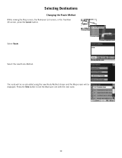
Press the View button to see the Maneuver List with the new route. 33 The route will be re-calculated using the new Route Method chosen and the Map screen will be displayed. Select Route. Selecting Destinations Changing the Route Method While viewing the Map screen, the Maneuver List screen, or the TrueView 3D screen, press the Cancel button. Select the new Route Method.
Press the View button to see the Maneuver List with the new route. 33 The route will be re-calculated using the new Route Method chosen and the Map screen will be displayed. Select Route. Selecting Destinations Changing the Route Method While viewing the Map screen, the Maneuver List screen, or the TrueView 3D screen, press the Cancel button. Select the new Route Method.

Manual - English
Page 39
Selecting Destinations Cancelling a Planned Route While viewing the Map screen, the Maneuver List screen, or the TrueView 3D screen, press the Cancel button. Select Yes to the last viewed screen. 34 Select No returns the display to cancel the route and display the Select Destination screen.
Selecting Destinations Cancelling a Planned Route While viewing the Map screen, the Maneuver List screen, or the TrueView 3D screen, press the Cancel button. Select Yes to the last viewed screen. 34 Select No returns the display to cancel the route and display the Select Destination screen.
Manual - English
Page 41
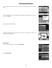
Select Done. The Magellan RoadMate will be displayed. Select Search By State. 36 Enter the street address. When the calculations are complete, the Map screen will calculate the route. The acceptable range of numbers is displayed at the top of the screen. Selecting Destinations Use the Navigation key to scroll the list up or down (if necessary) and select the desired street. Search By State From the Select Destination screen, select Street Address. Select the desired Route Method.
Select Done. The Magellan RoadMate will be displayed. Select Search By State. 36 Enter the street address. When the calculations are complete, the Map screen will calculate the route. The acceptable range of numbers is displayed at the top of the screen. Selecting Destinations Use the Navigation key to scroll the list up or down (if necessary) and select the desired street. Search By State From the Select Destination screen, select Street Address. Select the desired Route Method.
Manual - English
Page 43
Previous City From the Select Destination screen, select Street Address. Select Previous City. Enter the first few characters for the name of the street and select OK. 38 Select the city from the list. Select the desired Route Method. When the calculations are complete, the Map screen will calculate the route. Selecting Destinations The Magellan RoadMate will be displayed.
Previous City From the Select Destination screen, select Street Address. Select Previous City. Enter the first few characters for the name of the street and select OK. 38 Select the city from the list. Select the desired Route Method. When the calculations are complete, the Map screen will calculate the route. Selecting Destinations The Magellan RoadMate will be displayed.
Manual - English
Page 44
Select Done. Enter the street address. When the calculations are complete, the Map screen will calculate the route. The Magellan RoadMate will be displayed. 39 Select the desired Route Method. Selecting Destinations Use the Navigation key to scroll the list up or down (if necessary) and select the desired street. The acceptable range of numbers is displayed at the top of the screen.
Select Done. Enter the street address. When the calculations are complete, the Map screen will calculate the route. The Magellan RoadMate will be displayed. 39 Select the desired Route Method. Selecting Destinations Use the Navigation key to scroll the list up or down (if necessary) and select the desired street. The acceptable range of numbers is displayed at the top of the screen.
Manual - English
Page 46
... to the Address Book From the Select Destination screen, select Address Book. Select Edit. The address cannot be edited. When the calculations are complete, the Map screen will calculate the route. Selecting Destinations The Magellan RoadMate will be displayed.
... to the Address Book From the Select Destination screen, select Address Book. Select Edit. The address cannot be edited. When the calculations are complete, the Map screen will calculate the route. Selecting Destinations The Magellan RoadMate will be displayed.


