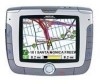
Manual - English
Page 6
... Satellite Navigation ...2 How Satellite Navigation Works ...2 Line of Sight ...2 A Word on the Safe Usage of GPS Maps ...3 From Source to Destination...3 Placement of Your GPS Receiver for Optimal Satellite Reception ...3 Signal Acquisition Time ...3 GPS Maps and Your Safety ...4 Chapter 3: Magellan RoadMate 6000T ...5 Front View ...5 Rear View ...6 Top View ...6 Bottom View ...7 Right Side View ...7 Left Side View ...8 cradle...
... Satellite Navigation ...2 How Satellite Navigation Works ...2 Line of Sight ...2 A Word on the Safe Usage of GPS Maps ...3 From Source to Destination...3 Placement of Your GPS Receiver for Optimal Satellite Reception ...3 Signal Acquisition Time ...3 GPS Maps and Your Safety ...4 Chapter 3: Magellan RoadMate 6000T ...5 Front View ...5 Rear View ...6 Top View ...6 Bottom View ...7 Right Side View ...7 Left Side View ...8 cradle...
Manual - English
Page 8
... ...55 Map Options ...60 TrueView Options ...60 Select Map Color...60 Route Preferences...61 Detour Options...62 Menu Colors...63 Tone Options...63 GPS Options...63 GPS Status ...63 Set GPS Position ...64 Simulator Mode...64 Automatic Volume...65 Backup and Restore...65 Backup ...65 Restore ...65 Map Information ...66 Trip Computer ...66... Chapter 9: Bluetooth ...70 How to use the Dialer ...70 Introduction ...70 Main Interface ...70 Pair Mode ...70 The pairing window shall pop up in your Magellan RoadMate.
... ...55 Map Options ...60 TrueView Options ...60 Select Map Color...60 Route Preferences...61 Detour Options...62 Menu Colors...63 Tone Options...63 GPS Options...63 GPS Status ...63 Set GPS Position ...64 Simulator Mode...64 Automatic Volume...65 Backup and Restore...65 Backup ...65 Restore ...65 Map Information ...66 Trip Computer ...66... Chapter 9: Bluetooth ...70 How to use the Dialer ...70 Introduction ...70 Main Interface ...70 Pair Mode ...70 The pairing window shall pop up in your Magellan RoadMate.

Manual - English
Page 10
... List View ...110 Thumbnail ...110 Rename ...110 Properties ...111 Tools ...111 Preferences...111 Delete Files ...111 About ...111 Chapter 17: Magellan RoadMate POI Manager ...112 Latitude ...112 Longitude ...112 Altitude ...113 Opening a POI File ...113 Creating a New POI FIle ...114 Adding... ...116 Appendix ...117 POI Categories ...117 Specifications ...119 PC Requirements ...119 GPS Status Screen ...120 GPS STATUS Screen Structure-first page ...120 Bad fix code ...120 GPS STATUS Screen Structure - second page ...121 Typical GPS STATUS Screen Display ...122 Frequently Asked Questions ...123 v
... List View ...110 Thumbnail ...110 Rename ...110 Properties ...111 Tools ...111 Preferences...111 Delete Files ...111 About ...111 Chapter 17: Magellan RoadMate POI Manager ...112 Latitude ...112 Longitude ...112 Altitude ...113 Opening a POI File ...113 Creating a New POI FIle ...114 Adding... ...116 Appendix ...117 POI Categories ...117 Specifications ...119 PC Requirements ...119 GPS Status Screen ...120 GPS STATUS Screen Structure-first page ...120 Bad fix code ...120 GPS STATUS Screen Structure - second page ...121 Typical GPS STATUS Screen Display ...122 Frequently Asked Questions ...123 v
Manual - English
Page 12
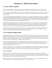
... by line of navigation, sports, and recreational activities. Global Positioning System (GPS) and the Russian GLObal NAvigation Satellite System (GLONASS). A third GNSS named GALILEO, after the Italian astronomer of the receiving device. GALILEO, scheduled to begin service in Europe specifically to provide a... the globe. A fourth satellite must be within line of sight of the receiver from the satellites and the time they orbit Earth in establishing the required integrity for GPS and GLONASS transmissions with global-positioning satellites. On average, eight satellites are two...
... by line of navigation, sports, and recreational activities. Global Positioning System (GPS) and the Russian GLObal NAvigation Satellite System (GLONASS). A third GNSS named GALILEO, after the Italian astronomer of the receiving device. GALILEO, scheduled to begin service in Europe specifically to provide a... the globe. A fourth satellite must be within line of sight of the receiver from the satellites and the time they orbit Earth in establishing the required integrity for GPS and GLONASS transmissions with global-positioning satellites. On average, eight satellites are two...
Manual - English
Page 13
... Magellan RoadMate 6000T, or if you use common sense. 2.3.1 From Source to provide a better user experience for our customers. For example, marine charts will affect the GPS signal. Therefore, when using GPS maps (just as possible, data from commercial and governmental cartographic sources that makes it presents is as robust as with our GPS devices to receive...
... Magellan RoadMate 6000T, or if you use common sense. 2.3.1 From Source to provide a better user experience for our customers. For example, marine charts will affect the GPS signal. Therefore, when using GPS maps (just as possible, data from commercial and governmental cartographic sources that makes it presents is as robust as with our GPS devices to receive...
Manual - English
Page 14
...not be used with common sense, and it is an aid to view the display while driving. For instance, the Magellan RoadMate 6000T GPS receiver should be your primary concern. road slope or grade; bridge height, width, weight or other assistance; construction work ...or other limits; Geological Survey (USGS), the National Oceanic and Atmospheric Administration (NOAA-NOS) and the Canadian Hydrographic Service (CHS). The Magellan GPS receiver must be operated only by vehicle passengers or by your relevant local knowledge, road signage, buoys, depth soundings and changing local conditions ...
...not be used with common sense, and it is an aid to view the display while driving. For instance, the Magellan RoadMate 6000T GPS receiver should be your primary concern. road slope or grade; bridge height, width, weight or other assistance; construction work ...or other limits; Geological Survey (USGS), the National Oceanic and Atmospheric Administration (NOAA-NOS) and the Canadian Hydrographic Service (CHS). The Magellan GPS receiver must be operated only by vehicle passengers or by your relevant local knowledge, road signage, buoys, depth soundings and changing local conditions ...
Manual - English
Page 19
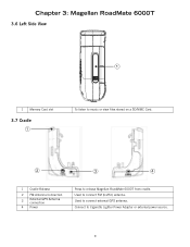
Chapter 3: Magellan RoadMate 6000T 3.6 Left Side View 1 Memory Card slot 3.7 Cradle To listen to music or view files stored on a SD/MMC Card. 1 Cradle Release 2 FM Antenna Connection 3 External GPS Antenna connection 4 Power Press to connect external GPS antenna. Used to release Magellan RoadMate 6000T from cradle. Connect to connect FM (traffic) antenna. Used to Cigarette Lighter Power Adapter or external power source. 9
Chapter 3: Magellan RoadMate 6000T 3.6 Left Side View 1 Memory Card slot 3.7 Cradle To listen to music or view files stored on a SD/MMC Card. 1 Cradle Release 2 FM Antenna Connection 3 External GPS Antenna connection 4 Power Press to connect external GPS antenna. Used to release Magellan RoadMate 6000T from cradle. Connect to connect FM (traffic) antenna. Used to Cigarette Lighter Power Adapter or external power source. 9
Manual - English
Page 29
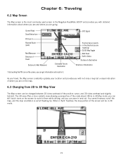
... screen to route to it. You cannot however, scroll the map, and the map orientation is the most commonly used screen in 2D mode. 19 GPS Signal Position Cursor (points in the direction you are traveling) 2D/3D Map Toggle Next Road Traffic Status Distance to Destination Direction of Destination As... to Destination † By touching the POI icon on the map. 6.3 Changing from 2D to 3D Map View The Map screen can be in the Magellan RoadMate 6000T and provides you with not only a map but a visual indication of where you are going.
... screen to route to it. You cannot however, scroll the map, and the map orientation is the most commonly used screen in 2D mode. 19 GPS Signal Position Cursor (points in the direction you are traveling) 2D/3D Map Toggle Next Road Traffic Status Distance to Destination Direction of Destination As... to Destination † By touching the POI icon on the map. 6.3 Changing from 2D to 3D Map View The Map screen can be in the Magellan RoadMate 6000T and provides you with not only a map but a visual indication of where you are going.
Manual - English
Page 75
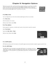
...acquisition time. 8.1.10.1 GPS Status The GPS Status screen is available by selecting one of four color schemes. GPS Status monitors the satellite signal. For more . 8.1.8 Menu Colors You can choose to ignore the Detour alert; Select Menu Colors. When you have the Magellan RoadMate 6000T calculate the detour. ...Chapter 8: Navigation Options When you encounter traffic, and the set time has elapsed again when it will flash on page 19) as well as the ability to "GPS Status Screen" on the screen to ...
...acquisition time. 8.1.10.1 GPS Status The GPS Status screen is available by selecting one of four color schemes. GPS Status monitors the satellite signal. For more . 8.1.8 Menu Colors You can choose to ignore the Detour alert; Select Menu Colors. When you have the Magellan RoadMate 6000T calculate the detour. ...Chapter 8: Navigation Options When you encounter traffic, and the set time has elapsed again when it will flash on page 19) as well as the ability to "GPS Status Screen" on the screen to ...
Manual - English
Page 76
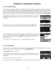
... "Inputting Text Characters" on page 14). In order for the Magellan RoadMate 6000T to reacquire a satellite signal. Select Set GPS Position. Enter the street name (see "Help with the Magellan RoadMate 6000T off the Simulator will "drive" at the top of the Magellan RoadMate 6000T, you are telling the Magellan RoadMate 6000T where you are in the range. If you do not know...
... "Inputting Text Characters" on page 14). In order for the Magellan RoadMate 6000T to reacquire a satellite signal. Select Set GPS Position. Enter the street name (see "Help with the Magellan RoadMate 6000T off the Simulator will "drive" at the top of the Magellan RoadMate 6000T, you are telling the Magellan RoadMate 6000T where you are in the range. If you do not know...
Manual - English
Page 113
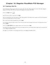
GPS Exchange file format (.GPS,.XML); Magellan Waypoint file format (.WPT,.RTE); If your Magellan RoadMate 6000T. Click on your file and click on Next. See page 57 for information on accessing custom POIs on The Save POI file button. Chapter 18: Magellan RoadMate POI Manager 18.7 Importing a Data FIle The ...the Open button . Select the file you just created and click on the pull down menu and assign a field name to your Magellan RoadMate 6000T. 103 Next, choose how the data is separated and click on Save. Assign a name to the appropriate column. Close the POI...
GPS Exchange file format (.GPS,.XML); Magellan Waypoint file format (.WPT,.RTE); If your Magellan RoadMate 6000T. Click on your file and click on Next. See page 57 for information on accessing custom POIs on The Save POI file button. Chapter 18: Magellan RoadMate POI Manager 18.7 Importing a Data FIle The ...the Open button . Select the file you just created and click on the pull down menu and assign a field name to your Magellan RoadMate 6000T. 103 Next, choose how the data is separated and click on Save. Assign a name to the appropriate column. Close the POI...

Manual - English
Page 116
Appendix Specifications DImensions: Weight: Display: Screen Resolution: Accepted Card Media: Audio: GPS Antenna: Battery: USB Interface: Operating Temperature: Storage Temperature: Humidity: PC Requirements 3.8" x 4.8" x 1.4" 9.6cm x 12.2cm x 3.5cm 8.64 oz. 245 g 3.5" color touch screen display, 2.11" x 2.81" (53....
Appendix Specifications DImensions: Weight: Display: Screen Resolution: Accepted Card Media: Audio: GPS Antenna: Battery: USB Interface: Operating Temperature: Storage Temperature: Humidity: PC Requirements 3.8" x 4.8" x 1.4" 9.6cm x 12.2cm x 3.5cm 8.64 oz. 245 g 3.5" color touch screen display, 2.11" x 2.81" (53....

Manual - English
Page 117
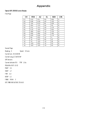
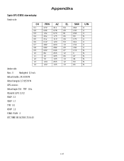
Appendix GPS Status Screen GPS STATUS Screen Structure-first page CH 01 02 03 04 05 06 07 08 09 10 11 12 13 14 PRN d1 d1 d1 d1 ...
Appendix GPS Status Screen GPS STATUS Screen Structure-first page CH 01 02 03 04 05 06 07 08 09 10 11 12 13 14 PRN d1 d1 d1 d1 ...
Manual - English
Page 118
... in map matching) UTC TIME MM/DD/YY HH:MM:SS(UTC time without local zone) 108 Appendix 17 ILL_DEFINED_2D_MATRIX 2X2 matrix can not be 0. GPS STATUS Screen Structure - range post-fix residuals chi-test failed 60 BAD_DOPPLER_CHITEST doppler post-fix residuals chi-test failed 61 OSC_DRIFT_ERR too much clock drift...
... in map matching) UTC TIME MM/DD/YY HH:MM:SS(UTC time without local zone) 108 Appendix 17 ILL_DEFINED_2D_MATRIX 2X2 matrix can not be 0. GPS STATUS Screen Structure - range post-fix residuals chi-test failed 60 BAD_DOPPLER_CHITEST doppler post-fix residuals chi-test failed 61 OSC_DRIFT_ERR too much clock drift...
Manual - English
Page 119
... 03E 13e 20e 31v 01V 28V 08V 02V 84 10 72 134 122 Second Page Heading 0 Speed 0.0 m/s Current Lat: 34.10939 N Current Long:117.82599 W GPS Version: Current altitude 255 TTFF 116s #Satellite (U/T) 11/12 PDOP 2.3 VDOP 1.7 TTFF 0.0 HDOP 1.3 FOMS P/V/H 2 UTC TIME 08/16/2004 22:56:53 AZ 311 078...
... 03E 13e 20e 31v 01V 28V 08V 02V 84 10 72 134 122 Second Page Heading 0 Speed 0.0 m/s Current Lat: 34.10939 N Current Long:117.82599 W GPS Version: Current altitude 255 TTFF 116s #Satellite (U/T) 11/12 PDOP 2.3 VDOP 1.7 TTFF 0.0 HDOP 1.3 FOMS P/V/H 2 UTC TIME 08/16/2004 22:56:53 AZ 311 078...
Manual - English
Page 121
... No. See "Chapter 18: Magellan RoadMate POI Manager" on page 99., and "Custom POIs" on ? The GPS signal is my street not showing up on this is new. Can I import a play MP3's and Route at the same time? Chances are, your Magellan RoadMate 6000T to make up . What's .... I know I use any third party SD/MMC card with the Magellan RoadMate 6000T The Magellan RoadMate 6000T is moved up for those you get better as more satellites are looking for it on page 57. The Magellan RoadMate 6000T uses the latest POI data available. These conditions may have the necessary...
... No. See "Chapter 18: Magellan RoadMate POI Manager" on page 99., and "Custom POIs" on ? The GPS signal is my street not showing up on this is new. Can I import a play MP3's and Route at the same time? Chances are, your Magellan RoadMate 6000T to make up . What's .... I know I use any third party SD/MMC card with the Magellan RoadMate 6000T The Magellan RoadMate 6000T is moved up for those you get better as more satellites are looking for it on page 57. The Magellan RoadMate 6000T uses the latest POI data available. These conditions may have the necessary...
Manual - Danish
Page 116
... 03 04 05 06 07 08 09 10 11 12 13 14 Anden side Kurs 0 Hastighed 0,0 m/s Aktuel bredde: 34.10939 N Aktuel længde:117.82599 W GPS-version: Aktuel højde 255 TTFF 116s #Satellit (U/T) 11/12 PDOP 2.3 VDOP 1.7 TTFF 0.0 HDOP 1.3 FOMS P/V/H 2 UTC TIME 08/16/2004 22:56:53 PRN 27V...
... 03 04 05 06 07 08 09 10 11 12 13 14 Anden side Kurs 0 Hastighed 0,0 m/s Aktuel bredde: 34.10939 N Aktuel længde:117.82599 W GPS-version: Aktuel højde 255 TTFF 116s #Satellit (U/T) 11/12 PDOP 2.3 VDOP 1.7 TTFF 0.0 HDOP 1.3 FOMS P/V/H 2 UTC TIME 08/16/2004 22:56:53 PRN 27V...
Manual - UK English
Page 6
... Satellite Navigation ...2 How Satellite Navigation Works ...2 Line of Sight ...2 A Word on the Safe Usage of GPS Maps ...3 From Source to Destination...3 Placement of Your GPS Receiver for Optimal Satellite Reception ...3 Signal Acquisition Time ...3 GPS Maps and Your Safety ...4 Chapter 3: Magellan RoadMate 6000T ...5 Front View ...5 Rear View ...6 Top View ...6 Bottom View ...7 Right Side View ...7 Left Side View ...8 Cradle...
... Satellite Navigation ...2 How Satellite Navigation Works ...2 Line of Sight ...2 A Word on the Safe Usage of GPS Maps ...3 From Source to Destination...3 Placement of Your GPS Receiver for Optimal Satellite Reception ...3 Signal Acquisition Time ...3 GPS Maps and Your Safety ...4 Chapter 3: Magellan RoadMate 6000T ...5 Front View ...5 Rear View ...6 Top View ...6 Bottom View ...7 Right Side View ...7 Left Side View ...8 Cradle...

Manual - UK English
Page 7
... ...64 TrueView Options ...64 Select Map Colour ...64 Route Preferences ...65 Detour Options ...66 Voice Options ...67 Menu Colours ...67 Tone Options ...67 GPS Options ...67 GPS Status...68 Set GPS Position ...68 Simulator Mode ...69 Automatic Volume ...69 TMC Options ...69 Navigation Instruction ...69 Backup and Restore ...69 Backup ...70 Restore ...70...
... ...64 TrueView Options ...64 Select Map Colour ...64 Route Preferences ...65 Detour Options ...66 Voice Options ...67 Menu Colours ...67 Tone Options ...67 GPS Options ...67 GPS Status...68 Set GPS Position ...68 Simulator Mode ...69 Automatic Volume ...69 TMC Options ...69 Navigation Instruction ...69 Backup and Restore ...69 Backup ...70 Restore ...70...
Manual - UK English
Page 9
... Manage Photos ...96 List View ...96 Thumbnail ...96 Rename ...96 Properties ...97 Tools ...97 Preferences...97 Delete Files ...97 About ...97 Chapter 18: Magellan RoadMate POI Manager ...98 Latitude ...98 Longitude ...98 Altitude ...99 Opening a POI File ...99 Creating a New POI FIle ...100 Adding Individual POIs ...100 ...further narrow the search by cuisine type, such as French, Italian, Greek, Mexican, etc 103 Specifications ...104 PC Requirements ...104 GPS Status Screen ...105 Optional Mounting ...108 Instructions for Mounting the Adhesive Disk ...108 Frequently Asked Questions ...109 iv
... Manage Photos ...96 List View ...96 Thumbnail ...96 Rename ...96 Properties ...97 Tools ...97 Preferences...97 Delete Files ...97 About ...97 Chapter 18: Magellan RoadMate POI Manager ...98 Latitude ...98 Longitude ...98 Altitude ...99 Opening a POI File ...99 Creating a New POI FIle ...100 Adding Individual POIs ...100 ...further narrow the search by cuisine type, such as French, Italian, Greek, Mexican, etc 103 Specifications ...104 PC Requirements ...104 GPS Status Screen ...105 Optional Mounting ...108 Instructions for Mounting the Adhesive Disk ...108 Frequently Asked Questions ...109 iv


