Operators Manual EN
Page 3
... contact your nearest distributor if you require any time which may be the official version of the manual. Trademarks Lowrance® and Navico® are registered trademarks of the National Marine Electronics Association. Navionics® is a registered... of Navionics, Inc. C-MAP® is the owner's sole responsibility to , or has been translated from, another language (Translation). Navico Holding AS and its subsidiaries, branches and affiliates reserve the right to make changes to specifications without notice. Preface | HDS Carbon Operator Manual 3 It is...
... contact your nearest distributor if you require any time which may be the official version of the manual. Trademarks Lowrance® and Navico® are registered trademarks of the National Marine Electronics Association. Navionics® is a registered... of Navionics, Inc. C-MAP® is the owner's sole responsibility to , or has been translated from, another language (Translation). Navico Holding AS and its subsidiaries, branches and affiliates reserve the right to make changes to specifications without notice. Preface | HDS Carbon Operator Manual 3 It is...

Operators Manual EN
Page 4
Wi-Fi® is a registered trademark of Bluetooth SIG, Inc. Additional mapping data: Copyright© 2012 NSI, Inc.: Copyright© 2012 by Richardson's Maptech. Bluetooth® is a registered trademark of the Wi-Fi Alliance®.... C-Monster™ is a registered trademark of Suzuki. SD™ and microSD™ are trademarks or registered trademarks of your display or system: www.lowrance.com. 4 Preface | HDS Carbon Operator Manual Power-Pole® is a registered trademark of Mercury. In case of any queries, refer to the following Navico products: • Broadband ...
Wi-Fi® is a registered trademark of Bluetooth SIG, Inc. Additional mapping data: Copyright© 2012 NSI, Inc.: Copyright© 2012 by Richardson's Maptech. Bluetooth® is a registered trademark of the Wi-Fi Alliance®.... C-Monster™ is a registered trademark of Suzuki. SD™ and microSD™ are trademarks or registered trademarks of your display or system: www.lowrance.com. 4 Preface | HDS Carbon Operator Manual Power-Pole® is a registered trademark of Mercury. In case of any queries, refer to the following Navico products: • Broadband ...
Operators Manual EN
Page 10
40 Chart overlay 40 Insight and C-MAP charts 45 Navionics charts 51 Chart settings 54 Waypoints, Routes, and Trails 54 Waypoints, Routes, and Trails dialogs 54 Waypoints 57 Routes 61 Trails 63 ... StructureScan image 83 Using the cursor on the StructureScan panel 84 Viewing StructureScan history 85 Setting up the StructureScan image 86 Stop sonar 10 Contents | HDS Carbon Operator Manual
40 Chart overlay 40 Insight and C-MAP charts 45 Navionics charts 51 Chart settings 54 Waypoints, Routes, and Trails 54 Waypoints, Routes, and Trails dialogs 54 Waypoints 57 Routes 61 Trails 63 ... StructureScan image 83 Using the cursor on the StructureScan panel 84 Viewing StructureScan history 85 Setting up the StructureScan image 86 Stop sonar 10 Contents | HDS Carbon Operator Manual

Operators Manual EN
Page 11
... tips 93 StructureMap 93 The StructureMap image 93 Activating Structure overlay 94 StructureMap sources 95 StructureMap tips 95 Recording StructureScan data 96 Using StructureMap with mapping cards 97 Structure options 99 Info panels 99 Dashboards 99 Customizing the Info panel 101 Video 101 The Video panel 101 Setting up the video... mode 105 Autopilot interface 106 Autopilot control of the trolling motor 109 Autopilot settings 112 Outboard motor autopilot 112 Safe operation with the autopilot Contents | HDS Carbon Operator Manual 11
... tips 93 StructureMap 93 The StructureMap image 93 Activating Structure overlay 94 StructureMap sources 95 StructureMap tips 95 Recording StructureScan data 96 Using StructureMap with mapping cards 97 Structure options 99 Info panels 99 Dashboards 99 Customizing the Info panel 101 Video 101 The Video panel 101 Setting up the video... mode 105 Autopilot interface 106 Autopilot control of the trolling motor 109 Autopilot settings 112 Outboard motor autopilot 112 Safe operation with the autopilot Contents | HDS Carbon Operator Manual 11

Operators Manual EN
Page 35
... system does not automatically switch to the embedded cartography. Charts | HDS Carbon Operator Manual 35 Chart data The system is removed. Charts on the Ethernet network - embedded, in the menu. The system also supports charts from Navionics and C-MAP as well as Lowrance in the card slot, or on chart cards are described. You...
... system does not automatically switch to the embedded cartography. Charts | HDS Carbon Operator Manual 35 Chart data The system is removed. Charts on the Ethernet network - embedded, in the menu. The system also supports charts from Navionics and C-MAP as well as Lowrance in the card slot, or on chart cards are described. You...

Operators Manual EN
Page 37
... information is used. Displaying information about chart items When you can maximize your system, you can select marine objects to display information Charts | HDS Carbon Operator Manual 37 If heading is not available, then the COG from the GPS is received from the menu. Ú Note: If you...the panel's upper right corner indicates the north direction. Positioning the vessel on the chart panel Chart orientation Several options are viewing applicable C-MAP charts on your view ahead. The chart orientation symbol in some cases is not the direction the vessel is rotated in the panel....
... information is used. Displaying information about chart items When you can maximize your system, you can select marine objects to display information Charts | HDS Carbon Operator Manual 37 If heading is not available, then the COG from the GPS is received from the menu. Ú Note: If you...the panel's upper right corner indicates the north direction. Positioning the vessel on the chart panel Chart orientation Several options are viewing applicable C-MAP charts on your view ahead. The chart orientation symbol in some cases is not the direction the vessel is rotated in the panel....
Operators Manual EN
Page 40
When an overlay is selected, the chart menu expands to predict the time, level, direction and 40 Charts | HDS Carbon Operator Manual For more information about SonarChart Live, see section "SonarChart Live" on page 37. For example, raster charts are not available with ... on page 46. Chart overlay Radar, structure, SonarChart Live (Navionics charts only) and weather data can be adjusted. With this manual. Insight and C-MAP tides and currents The system can vary depending on the charts you are viewing, pan horizontally • To change the direction you use. This section...
When an overlay is selected, the chart menu expands to predict the time, level, direction and 40 Charts | HDS Carbon Operator Manual For more information about SonarChart Live, see section "SonarChart Live" on page 37. For example, raster charts are not available with ... on page 46. Chart overlay Radar, structure, SonarChart Live (Navionics charts only) and weather data can be adjusted. With this manual. Insight and C-MAP tides and currents The system can vary depending on the charts you are viewing, pan horizontally • To change the direction you use. This section...
Operators Manual EN
Page 42
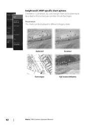
Shaded relief No contours Raster imagery High resolution bathymetry 42 Charts | HDS Carbon Operator Manual Insight and C-MAP specific chart options Orientation, Look ahead, 3D, and change Chart source (previously described in different imagery styles. Presentation The charts can be displayed in this section) are common for all chart types.
Shaded relief No contours Raster imagery High resolution bathymetry 42 Charts | HDS Carbon Operator Manual Insight and C-MAP specific chart options Orientation, Look ahead, 3D, and change Chart source (previously described in different imagery styles. Presentation The charts can be displayed in this section) are common for all chart types.
Operators Manual EN
Page 43
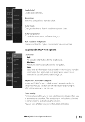
... paper chart. Raster transparency Controls the transparency of contour lines. You can turn on/off individually depending on the chart. Charts | HDS Carbon Operator Manual 43 Shaded relief Shades seabed terrain. Photo overlay Photo overlay enables you to view satellite photo images of such photos is... required in all geographic areas. Insight and C-MAP view options Chart detail • Full All available information for the chart in either 2D or 3D modes. High resolution bathymetry ...
... paper chart. Raster transparency Controls the transparency of contour lines. You can turn on/off individually depending on the chart. Charts | HDS Carbon Operator Manual 43 Shaded relief Shades seabed terrain. Photo overlay Photo overlay enables you to view satellite photo images of such photos is... required in all geographic areas. Insight and C-MAP view options Chart detail • Full All available information for the chart in either 2D or 3D modes. High resolution bathymetry ...
Operators Manual EN
Page 44
... values shallower than the selected depth filter limit. 44 Charts | HDS Carbon Operator Manual Paper chart Changes the appearance of the photo overlay. No Photo overlay Photo overlay, land only Full Photo overlay Photo transparency The Photo transparency sets the opaqueness of the map to distinguish between shallow (lighter shades) and deep (darker...
... values shallower than the selected depth filter limit. 44 Charts | HDS Carbon Operator Manual Paper chart Changes the appearance of the photo overlay. No Photo overlay Photo overlay, land only Full Photo overlay Photo transparency The Photo transparency sets the opaqueness of the map to distinguish between shallow (lighter shades) and deep (darker...
Operators Manual EN
Page 45
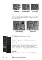
Exaggeration is not available in the map card inserted. Navionics charts Some Navionics features require the most current data from Navionics. For those features, a message is displayed stating that are not applicable .... Custom You can adjust the depth threshold, color and opacity (transparency) of color shading for Depth 1 and Depth 2. 3D exaggeration Graphical settings that the Charts | HDS Carbon Operator Manual 45 Depth 1 and Depth 2 Depth presets that shade different depths in different colors. Shading Shades different areas of the seabed, depending on land...
Exaggeration is not available in the map card inserted. Navionics charts Some Navionics features require the most current data from Navionics. For those features, a message is displayed stating that are not applicable .... Custom You can adjust the depth threshold, color and opacity (transparency) of color shading for Depth 1 and Depth 2. 3D exaggeration Graphical settings that the Charts | HDS Carbon Operator Manual 45 Depth 1 and Depth 2 Depth presets that shade different depths in different colors. Shading Shades different areas of the seabed, depending on land...

Operators Manual EN
Page 50
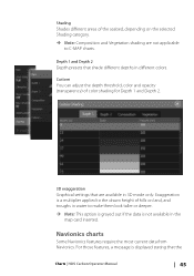
...range: 6 m - 12 m Shallow water highlight Highlights areas of the SonarChart and SonarChart Live contours. No shallow water highlighted Shallow water highlight: 0 m - 3 m 50 Charts | HDS Carbon Operator Manual This allows you to highlight areas of depths for fishing purposes. The range is only as accurate as the underlying chart data, meaning...available contour line. For more information, refer to 10 meters/30 feet). SC Density Controls the density of shallow water. SonarChart displays a bathymetry map showing high resolution contour detail and standard navigational data.
...range: 6 m - 12 m Shallow water highlight Highlights areas of the SonarChart and SonarChart Live contours. No shallow water highlighted Shallow water highlight: 0 m - 3 m 50 Charts | HDS Carbon Operator Manual This allows you to highlight areas of depths for fishing purposes. The range is only as accurate as the underlying chart data, meaning...available contour line. For more information, refer to 10 meters/30 feet). SC Density Controls the density of shallow water. SonarChart displays a bathymetry map showing high resolution contour detail and standard navigational data.

Operators Manual EN
Page 57
... radius. If you set an alarm radius for Navionics Autorouting and C-MAP Easy Routing. The alarm is displayed. You can set the new routepoint on the chart panel until the route is added between existing routepoints Waypoints, Routes, and Trails | HDS Carbon Operator Manual 57 Continue positioning new routepoints on a leg, a new point...
... radius. If you set an alarm radius for Navionics Autorouting and C-MAP Easy Routing. The alarm is displayed. You can set the new routepoint on the chart panel until the route is added between existing routepoints Waypoints, Routes, and Trails | HDS Carbon Operator Manual 57 Continue positioning new routepoints on a leg, a new point...

Operators Manual EN
Page 59
...when they are disabled on your boat's size. For a full selection of the open an existing route for sale in the map and on all non-U.S. Select Dock-to -dock Autorouting and Easy Routing suggest new routepoint positions based on information in the ...MAP MAX-N+, Navionics+ and Navionics Platinum. A warning dialog is located in U.S. Entire Route if you want the system to proceed. Ú Note: If no compatible cartography is available, the Dock-todock Autorouting or Easy Routing menu option is missing when you have Autorouting capabilities. Waypoints, Routes, and Trails | HDS Carbon...
...when they are disabled on your boat's size. For a full selection of the open an existing route for sale in the map and on all non-U.S. Select Dock-to -dock Autorouting and Easy Routing suggest new routepoint positions based on information in the ...MAP MAX-N+, Navionics+ and Navionics Platinum. A warning dialog is located in U.S. Entire Route if you want the system to proceed. Ú Note: If no compatible cartography is available, the Dock-todock Autorouting or Easy Routing menu option is missing when you have Autorouting capabilities. Waypoints, Routes, and Trails | HDS Carbon...

Operators Manual EN
Page 60
... C-MAP uses red (unsafe), yellow (dangerous) and green (safe). 4. Select Accept to complete the automatic routing and save the route. Eventually repeat step 2 (Selection) and step 3 if you want the system to manually select the routepoints that define the limits for other parts of a route. 60 Waypoints, Routes, and Trails | HDS Carbon Operator...
... C-MAP uses red (unsafe), yellow (dangerous) and green (safe). 4. Select Accept to complete the automatic routing and save the route. Eventually repeat step 2 (Selection) and step 3 if you want the system to manually select the routepoints that define the limits for other parts of a route. 60 Waypoints, Routes, and Trails | HDS Carbon Operator...

Operators Manual EN
Page 93
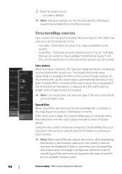
You move around in the chart as Structure overlay is enabled StructureMap | HDS Carbon Operator Manual 93 Activating Structure overlay 1. The chart menu is increased to your position, and aids in relation to show Structure options - The ... zoom (+ or -) buttons, or by using the +/- This makes it easier to visualize the underwater environment in interpreting SideScan images. Turn on the map. 10 StructureMap The StructureMap feature overlays SideScan images from a StructureScan source on Structure overlay from the panel, and the chart center is positioned at the...
You move around in the chart as Structure overlay is enabled StructureMap | HDS Carbon Operator Manual 93 Activating Structure overlay 1. The chart menu is increased to your position, and aids in relation to show Structure options - The ... zoom (+ or -) buttons, or by using the +/- This makes it easier to visualize the underwater environment in interpreting SideScan images. Turn on the map. 10 StructureMap The StructureMap feature overlays SideScan images from a StructureScan source on Structure overlay from the panel, and the chart center is positioned at the...
Operators Manual EN
Page 94
...displayed as the source, all recent data is large enough to show Structure details. Saved files When Saved files are required, the maps should be put on position information in the files browser. If several logs of the same area are selected, the StructureMap file ...system's internal memory are converted to position the vessel on specific points of the StructureScan transducer is overlaid on the map based on separate memory cards. 94 StructureMap | HDS Carbon Operator Manual If the unit is turned off, all StructureMap files found on the system. • Saved files...
...displayed as the source, all recent data is large enough to show Structure details. Saved files When Saved files are required, the maps should be put on position information in the files browser. If several logs of the same area are selected, the StructureMap file ...system's internal memory are converted to position the vessel on specific points of the StructureScan transducer is overlaid on the map based on separate memory cards. 94 StructureMap | HDS Carbon Operator Manual If the unit is turned off, all StructureMap files found on the system. • Saved files...
Operators Manual EN
Page 96
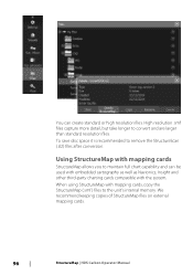
We recommend keeping copies of StructureMap files on external mapping cards. 96 StructureMap | HDS Carbon Operator Manual Using StructureMap with mapping cards StructureMap allows you to convert and are larger than standard resolution files. High resolution .smf files capture more ... high resolution files. You can be used with embedded cartography as well as Navionics, Insight and other third-party charting cards compatible with mapping cards, copy the StructureMap (.smf ) files to remove the StructureScan (.sl2) files after conversion. When using StructureMap with the system. ...
We recommend keeping copies of StructureMap files on external mapping cards. 96 StructureMap | HDS Carbon Operator Manual Using StructureMap with mapping cards StructureMap allows you to convert and are larger than standard resolution files. High resolution .smf files capture more ... high resolution files. You can be used with embedded cartography as well as Navionics, Insight and other third-party charting cards compatible with mapping cards, copy the StructureMap (.smf ) files to remove the StructureScan (.sl2) files after conversion. When using StructureMap with the system. ...

Operators Manual EN
Page 97
... details are almost hidden by the unit. 800 kHz offers the best resolution, while 455 kHz has greater depth and range coverage. StructureMap | HDS Carbon Operator Manual 97 Unavailable options are used by the StructureMap overlay. The menu is available when Structure overlay is enabled. Not all options are available...from the screen and begins showing only the most current data. If turned ON the accuracy of bait fish might be seen on the map might not be affected by the water depth. Water column Shows/hides the water column in Live mode. Clear live history Clears existing ...
... details are almost hidden by the unit. 800 kHz offers the best resolution, while 455 kHz has greater depth and range coverage. StructureMap | HDS Carbon Operator Manual 97 Unavailable options are used by the StructureMap overlay. The menu is available when Structure overlay is enabled. Not all options are available...from the screen and begins showing only the most current data. If turned ON the accuracy of bait fish might be seen on the map might not be affected by the water depth. Water column Shows/hides the water column in Live mode. Clear live history Clears existing ...

Operators Manual EN
Page 123
...from a wireless hotspot, select the Wireless option in your Sonar logs to create custom maps at Insight Genesis. • Download software updates • Connect to Access point Wireless connection | HDS Carbon Operator Manual 123 Use this mode, you can be large. The built-in the ...System Controls dialog and then select Not Connected. This changes the wireless mode to third party applications Ú Note: Maps, charts, software updates, and other...
...from a wireless hotspot, select the Wireless option in your Sonar logs to create custom maps at Insight Genesis. • Download software updates • Connect to Access point Wireless connection | HDS Carbon Operator Manual 123 Use this mode, you can be large. The built-in the ...System Controls dialog and then select Not Connected. This changes the wireless mode to third party applications Ú Note: Maps, charts, software updates, and other...


