Owners Manual
Page 1
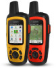
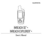
INREACH SE®+ INREACH EXPLORER®+ Owner's Manual
INREACH SE®+ INREACH EXPLORER®+ Owner's Manual

Owners Manual
Page 2
These trademarks may not be used without obligation to www.garmin.com for current updates and supplemental information concerning the use of Garmin Ltd. Facebook™ and the Facebook logo are owned by Garmin is a registered trademark of Garmin. Garmin reserves the right to make changes in the USA and other countries. MapShare™ is a trademark of their respective owners. The Bluetooth® word mark...
These trademarks may not be used without obligation to www.garmin.com for current updates and supplemental information concerning the use of Garmin Ltd. Facebook™ and the Facebook logo are owned by Garmin is a registered trademark of Garmin. Garmin reserves the right to make changes in the USA and other countries. MapShare™ is a trademark of their respective owners. The Bluetooth® word mark...
Owners Manual
Page 3
... 5 Editing a Weather Location 5 Deleting a Weather Location 5 Data Use and History 5 Viewing Data Use 5 Viewing Data History 5 Customizing the Device 6 Display Settings 6 Map Settings 6 Tracking Settings 6 Bluetooth Settings 6 Compass and Altimeter Settings 6 Messages Settings 6 Sounds Settings 7 Time Settings 7 Units Settings 7 External Power Settings 7 Changing the Device Language 7 Adding Owner Information 7 Device Information 7 Support and Updates 7 Attaching the Carabiner Clip 7 Attaching a Lanyard 7 Locking and Unlocking the Keys 7 Device Care 7 Troubleshooting...
... 5 Editing a Weather Location 5 Deleting a Weather Location 5 Data Use and History 5 Viewing Data Use 5 Viewing Data History 5 Customizing the Device 6 Display Settings 6 Map Settings 6 Tracking Settings 6 Bluetooth Settings 6 Compass and Altimeter Settings 6 Messages Settings 6 Sounds Settings 7 Time Settings 7 Units Settings 7 External Power Settings 7 Changing the Device Language 7 Adding Owner Information 7 Device Information 7 Support and Updates 7 Attaching the Carabiner Clip 7 Attaching a Lanyard 7 Locking and Unlocking the Keys 7 Device Care 7 Troubleshooting...
Owners Manual
Page 5
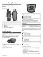
... a clear view of the sky. Getting Started WARNING See the Important Safety and Product Information guide in the product box for GPS signal Sending and receiving data Unable to send and receive data Unread messages Tracking enabled Bluetooth® technology status Charging battery Charging complete Activating the Device Before you can use your inReach® device, you must activate it is below 10% battery power. Select to acknowledge a message. Select twice to an open the home page...
... a clear view of the sky. Getting Started WARNING See the Important Safety and Product Information guide in the product box for GPS signal Sending and receiving data Unable to send and receive data Unread messages Tracking enabled Bluetooth® technology status Charging battery Charging complete Activating the Device Before you can use your inReach® device, you must activate it is below 10% battery power. Select to acknowledge a message. Select twice to an open the home page...
Owners Manual
Page 6
...: • Select Message: to create a new message. • Select to activate your satellite subscription is 10 minutes. The device must be sent to send the information until it on your mobile device. Without a clear view of each other. 3 On the inReach device, select Settings > Bluetooth > Pair Device > Pair Device. 4 Follow the instructions in view of a satellite at inreach.garmin.com. After the devices are paired, they connect automatically when they are messages that includes . 4 Select Navigate. 2 Bluetooth Connected Features Satellites announce recently sent...
...: • Select Message: to create a new message. • Select to activate your satellite subscription is 10 minutes. The device must be sent to send the information until it on your mobile device. Without a clear view of each other. 3 On the inReach device, select Settings > Bluetooth > Pair Device > Pair Device. 4 Follow the instructions in view of a satellite at inreach.garmin.com. After the devices are paired, they connect automatically when they are messages that includes . 4 Select Navigate. 2 Bluetooth Connected Features Satellites announce recently sent...
Owners Manual
Page 7
... minutes when stationary. You can view the number of interacting with them to your location and updates the track line on the device, that you wait for help . Deleting a Contact 1 Select Contacts. 2 Select a contact. 3 Select Delete. Deleting Messages 1 Select Messages. 2 Select a conversation. 3 Select > Delete Thread. Editing a Contact 1 Select Contacts. 2 Select a contact. 3 Select an item to edit. 4 Enter the new information. To conserve battery power after the first 10 minutes, an updated location is sent every 10 minutes when...
... minutes when stationary. You can view the number of interacting with them to your location and updates the track line on the device, that you wait for help . Deleting a Contact 1 Select Contacts. 2 Select a contact. 3 Select Delete. Deleting Messages 1 Select Messages. 2 Select a conversation. 3 Select > Delete Thread. Editing a Contact 1 Select Contacts. 2 Select a contact. 3 Select an item to edit. 4 Enter the new information. To conserve battery power after the first 10 minutes, an updated location is sent every 10 minutes when...
Owners Manual
Page 8
.... 1 Select Map. 2 Select a location on your trip. Sending a Reference Point You can customize the information displayed on Map. Deleting a Waypoint 1 Select Waypoints. 2 Select a waypoint. 3 Select > Delete. When you turn on your navigation device, whether you must collect satellite data and establish the current location. You can view the route you last used your final destination. Map The map page shows your location, sent and received messages, waypoints, and a colored track line connecting your navigation device, the GPS receiver must acquire satellite signals...
.... 1 Select Map. 2 Select a location on your trip. Sending a Reference Point You can customize the information displayed on Map. Deleting a Waypoint 1 Select Waypoints. 2 Select a waypoint. 3 Select > Delete. When you turn on your navigation device, whether you must collect satellite data and establish the current location. You can view the route you last used your final destination. Map The map page shows your location, sent and received messages, waypoints, and a colored track line connecting your navigation device, the GPS receiver must acquire satellite signals...
Owners Manual
Page 9
... request a marine forecast for your current location, a waypoint, or GPS coordinates. Compass The compass features and appearance change depending on your heading when you are tracking or navigating to edit, such as times, distance, and speeds, select Reset Trip. • To clear trip information and reset the odometer, select Reset All. Points in that direction to a destination. Indicates your speed. On inReach Explorer+ devices, indicates your MapShare web page. 2 Select Compass. 3 Turn until the heading pointer aligns...
... request a marine forecast for your current location, a waypoint, or GPS coordinates. Compass The compass features and appearance change depending on your heading when you are tracking or navigating to edit, such as times, distance, and speeds, select Reset Trip. • To clear trip information and reset the odometer, select Reset All. Points in that direction to a destination. Indicates your speed. On inReach Explorer+ devices, indicates your MapShare web page. 2 Select Compass. 3 Turn until the heading pointer aligns...
Owners Manual
Page 10
... on-screen instructions. Connected: Displays the current Bluetooth connection status, and allows you read a new message. If you are in a noisy environment. Ring Until Read: Sets the device to ring until you to remove a paired device. This feature is only available for MapShare: Sets the device to prompt you to send a message with a compatible Bluetooth enabled mobile device. Navigating to prevent inadvertent key presses (Locking and Unlocking the Keys, page 7). Deleting Data History 1 Select History. 2 Select a day. 3 Select Delete. Brightness: Sets...
... on-screen instructions. Connected: Displays the current Bluetooth connection status, and allows you read a new message. If you are in a noisy environment. Ring Until Read: Sets the device to ring until you to remove a paired device. This feature is only available for MapShare: Sets the device to prompt you to send a message with a compatible Bluetooth enabled mobile device. Navigating to prevent inadvertent key presses (Locking and Unlocking the Keys, page 7). Deleting Data History 1 Select History. 2 Select a day. 3 Select Delete. Brightness: Sets...
Owners Manual
Page 11
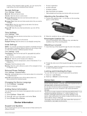
... are using or charging. Coordinates: Sets the format used for the device. Pressure: Sets the pressure units. Changing the Device Language 1 Select Settings > Language. 2 Select a language. Device Information 7 Volume: Sets the device volume level. Attaching a Lanyard 1 Insert the loop of the carabiner clip, and slide the carabiner clip off the device. • Product registration • Product manuals • Firmware updates • Map downloads and updates • Data uploads and syncing your clothing or backpack to the device. The device is disconnected from external power...
... are using or charging. Coordinates: Sets the format used for the device. Pressure: Sets the pressure units. Changing the Device Language 1 Select Settings > Language. 2 Select a language. Device Information 7 Volume: Sets the device volume level. Attaching a Lanyard 1 Insert the loop of the carabiner clip, and slide the carabiner clip off the device. • Product registration • Product manuals • Firmware updates • Map downloads and updates • Data uploads and syncing your clothing or backpack to the device. The device is disconnected from external power...
Owners Manual
Page 12
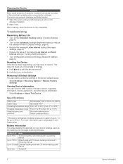
... contacts when connected to a charger. Viewing Device Information You can restore all device settings to the factory default values. Battery Information The actual battery life depends on the device. Default mode with 10-minute tracking interval and 1minute log interval Up to 30 days Extended tracking mode with a mild detergent solution. 2 Wipe it . Select Settings > Recovery Options > Restore Factory Settings. Specifications Battery type Rechargeable, built-in lithium-ion battery Water rating IEC 60529 IPX7* Operating temperature range...
... contacts when connected to a charger. Viewing Device Information You can restore all device settings to the factory default values. Battery Information The actual battery life depends on the device. Default mode with 10-minute tracking interval and 1minute log interval Up to 30 days Extended tracking mode with a mild detergent solution. 2 Wipe it . Select Settings > Recovery Options > Restore Factory Settings. Specifications Battery type Rechargeable, built-in lithium-ion battery Water rating IEC 60529 IPX7* Operating temperature range...
Owners Manual
Page 13
See routes troubleshooting 8 U units of measure 7 updating software 7 USB, connector 1 W waypoints 4, 6 deleting 4 editing 4 navigating 4 saving 4 viewing on the map 4 S satellite signals 2 acquiring 4 screen 6 settings 6, 7 smartphone applications 2 pairing 2 software, updating 7 SOS 1, 3 canceling 3 sending 3 specifications 8 T testing the device 2 time, zones and formats 7 time settings 7 tones 7 track points, navigating 6 tracking 3, 4, 6 trip information resetting 5 viewing 4 trip planner. Index A altimeter 6 calibrating 6 applications 2 B backlight 6 barometer 6 battery 7 charging 1 ...
See routes troubleshooting 8 U units of measure 7 updating software 7 USB, connector 1 W waypoints 4, 6 deleting 4 editing 4 navigating 4 saving 4 viewing on the map 4 S satellite signals 2 acquiring 4 screen 6 settings 6, 7 smartphone applications 2 pairing 2 software, updating 7 SOS 1, 3 canceling 3 sending 3 specifications 8 T testing the device 2 time, zones and formats 7 time settings 7 tones 7 track points, navigating 6 tracking 3, 4, 6 trip information resetting 5 viewing 4 trip planner. Index A altimeter 6 calibrating 6 applications 2 B backlight 6 barometer 6 battery 7 charging 1 ...

