
Owner's Manual
Page 22
..., and press Enter. Make changes by highlighting each field, and use the waypoint symbol chart and alphanumeric keypad to delete the waypoint. 12 eTrex Venture Cx and Legend Cx Owner's Manual Highlight Yes, and press Enter to enter new data. 5. Press and hold the Find key to open the Waypoints Page. 3. To delete..., you cannot recover it from the Waypoint Page. Deleting Waypoints You can edit waypoints to exit. Press Quit to change the symbol, name, note, location, elevation, and depth.
..., and press Enter. Make changes by highlighting each field, and use the waypoint symbol chart and alphanumeric keypad to delete the waypoint. 12 eTrex Venture Cx and Legend Cx Owner's Manual Highlight Yes, and press Enter to enter new data. 5. Press and hold the Find key to open the Waypoints Page. 3. To delete..., you cannot recover it from the Waypoint Page. Deleting Waypoints You can edit waypoints to exit. Press Quit to change the symbol, name, note, location, elevation, and depth.
Owner's Manual
Page 48
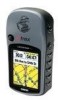
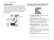
...the unit on or off. • Track Up/North Up-indicates whether satellites are having trouble locking onto satellite signals. • GPS Elevation-shows your current track toward the top of the screen. • Multicolor/Single Color-indicates whether each satellite displays in a different color or... Off/On-enables you are shown with the rings oriented with North toward the top of the display or your current elevation. 38 eTrex Venture Cx and Legend Cx Owner's Manual The Satellite Page appears when you turn the GPS receiver on and is accessed from at least three satellites.
...the unit on or off. • Track Up/North Up-indicates whether satellites are having trouble locking onto satellite signals. • GPS Elevation-shows your current track toward the top of the screen. • Multicolor/Single Color-indicates whether each satellite displays in a different color or... Off/On-enables you are shown with the rings oriented with North toward the top of the display or your current elevation. 38 eTrex Venture Cx and Legend Cx Owner's Manual The Satellite Page appears when you turn the GPS receiver on and is accessed from at least three satellites.

Owner's Manual
Page 73
... Menu Page, highlight the Heading icon, and press Enter. • Display-sets the value (Cardinal Letters, Degrees, or Mils) for speed and distance traveled. • Elevation (Vert. To access the Interface Setup Page: On the Setup Menu Page, highlight the Units icon, and press Enter. • Position Format-sets a coordinate system.... Speed)-sets the unit of measurement (Feet (ft/min), Meters (m/min), or Meters (m/sec)) to use for altitude. • Depth-sets the unit of measure. eTrex Venture Cx and Legend Cx Owner's Manual 63
... Menu Page, highlight the Heading icon, and press Enter. • Display-sets the value (Cardinal Letters, Degrees, or Mils) for speed and distance traveled. • Elevation (Vert. To access the Interface Setup Page: On the Setup Menu Page, highlight the Units icon, and press Enter. • Position Format-sets a coordinate system.... Speed)-sets the unit of measurement (Feet (ft/min), Meters (m/min), or Meters (m/sec)) to use for altitude. • Depth-sets the unit of measure. eTrex Venture Cx and Legend Cx Owner's Manual 63
Owner's Manual
Page 84
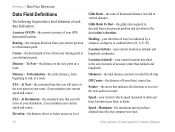
... direct course line. Maximum-the maximum speed you have attained since the trip computer was reset. 74 eTrex Venture Cx and Legend Cx Owner's Manual Accuracy Of GPS-the current accuracy of measure (other than latitude and longitude). Elevation-the distance above or below mean sea level. APPENDIX > DATA FIELD DEFINITIONS Data Field Defi...
... direct course line. Maximum-the maximum speed you have attained since the trip computer was reset. 74 eTrex Venture Cx and Legend Cx Owner's Manual Accuracy Of GPS-the current accuracy of measure (other than latitude and longitude). Elevation-the distance above or below mean sea level. APPENDIX > DATA FIELD DEFINITIONS Data Field Defi...


