Owners Manual
Page 3
.............16 Map 16 Compass 17 Elevation Plot 19 Trip Computer 20 eTrex Owner's Manual Table of Contents Geocaches 21 Downloading Geocaches 21 Filtering the Geocache List..........21 Navigating to a Geocache............22 Logging the Attempt 22 chirp 23 Applications 24 Sharing Data 24 Setting a Proximity Alarm 24 Calculating the Size of Contents Getting Started 5 Device Overview 5 Using the eTrex Keys 6 Battery Information 7 Turning the Device On or Off.........8 Satellite Signals 8 Registering Your Device 8 Waypoints, Routes, and Tracks 9 Waypoints 9 Using Sight...
.............16 Map 16 Compass 17 Elevation Plot 19 Trip Computer 20 eTrex Owner's Manual Table of Contents Geocaches 21 Downloading Geocaches 21 Filtering the Geocache List..........21 Navigating to a Geocache............22 Logging the Attempt 22 chirp 23 Applications 24 Sharing Data 24 Setting a Proximity Alarm 24 Calculating the Size of Contents Getting Started 5 Device Overview 5 Using the eTrex Keys 6 Battery Information 7 Turning the Device On or Off.........8 Satellite Signals 8 Registering Your Device 8 Waypoints, Routes, and Tracks 9 Waypoints 9 Using Sight...
Owners Manual
Page 4
... Tracks Settings 32 Changing the Units of Measure...33 Time Settings 33 Position Format Settings 33 Heading Settings 34 Altimeter Settings 34 Geocaching Settings 35 Routing Settings 36 Marine Map Settings 37 Fitness 38 Resetting Data 38 Changing the Page Sequence.....39 Device Information 40 Adjusting the Screen 40 Updating the Software 40 Viewing Device Information..........40 Specifications 41 About the Batteries 41 Caring for the Device 42 Data Management 43 Appendix 46 Optional Accessories 46 Data Field Options 47 Troubleshooting 52 Index 54 4 eTrex Owner's Manual
... Tracks Settings 32 Changing the Units of Measure...33 Time Settings 33 Position Format Settings 33 Heading Settings 34 Altimeter Settings 34 Geocaching Settings 35 Routing Settings 36 Marine Map Settings 37 Fitness 38 Resetting Data 38 Changing the Page Sequence.....39 Device Information 40 Adjusting the Screen 40 Updating the Software 40 Viewing Device Information..........40 Specifications 41 About the Batteries 41 Caring for the Device 42 Data Management 43 Appendix 46 Optional Accessories 46 Data Field Options 47 Troubleshooting 52 Index 54 4 eTrex Owner's Manual
Owners Manual
Page 5
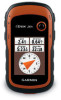
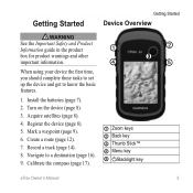
... for product warnings and other important information. ➍ ➋ ➌ ➎ When using your device the first time, you should complete these tasks to set up the device and get to a destination (page 16). 9. Install the batteries (page 7). 2. Acquire satellites (page 8). 4. Record a track (page 14). 8. Mark a waypoint (page 9). 6. Create a route (page 12). 7. Calibrate the compass (page 17). ➊ Zoom keys ➋ Back key ➌ Thumb Stick™ ➍ Menu key ➎ /Backlight key eTrex Owner's Manual 5
... for product warnings and other important information. ➍ ➋ ➌ ➎ When using your device the first time, you should complete these tasks to set up the device and get to a destination (page 16). 9. Install the batteries (page 7). 2. Acquire satellites (page 8). 4. Record a track (page 14). 8. Mark a waypoint (page 9). 6. Create a route (page 12). 7. Calibrate the compass (page 17). ➊ Zoom keys ➋ Back key ➌ Thumb Stick™ ➍ Menu key ➎ /Backlight key eTrex Owner's Manual 5
Owners Manual
Page 11
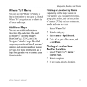
..., geographic points, and various points of interest, such as BirdsEye™ satellite imagery, BlueChart® g2, TOPO, and City Navigator® detailed maps. Detailed maps may contain additional points of interest (POIs), such as restaurants, hotels, and auto services. 1. For more information, go to . Waypoints, Routes, and Tracks Finding a Location by Name Depending on the maps loaded on the eTrex 20x and eTrex 30x, such as restaurants or marine services.
..., geographic points, and various points of interest, such as BirdsEye™ satellite imagery, BlueChart® g2, TOPO, and City Navigator® detailed maps. Detailed maps may contain additional points of interest (POIs), such as restaurants, hotels, and auto services. 1. For more information, go to . Waypoints, Routes, and Tracks Finding a Location by Name Depending on the maps loaded on the eTrex 20x and eTrex 30x, such as restaurants or marine services.
Owners Manual
Page 13
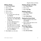
...; To view the point on the map, select Review. • To change the order of the point on the route, select Move Down or Move Up. • To add an additional point on the Map 1. Select Route Planner. 2. Select Route Planner. 2. Editing a Route 1. Select a point. 5. Select a route. 3. While navigating a route, select Active Route. 2. eTrex Owner's Manual 13 Select Edit Route. 4. Deleting a Route 1. Viewing the Active Route 1. Select Route Planner. 2. Select a route. 3. Select Reverse Route. Select Route Planner. 2. Select Delete Route. The additional...
...; To view the point on the map, select Review. • To change the order of the point on the route, select Move Down or Move Up. • To add an additional point on the Map 1. Select Route Planner. 2. Select Route Planner. 2. Editing a Route 1. Select a point. 5. Select a route. 3. While navigating a route, select Active Route. 2. eTrex Owner's Manual 13 Select Edit Route. 4. Deleting a Route 1. Viewing the Active Route 1. Select Route Planner. 2. Select a route. 3. Select Reverse Route. Select Route Planner. 2. Select Delete Route. The additional...
Owners Manual
Page 14
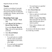
... time, location, and elevation for each point. Select Record Method. 4. Select Record, Do Not Show or Record, Show On Map. If you move with the device turned on the map indicates your tracks, select Auto. • To record tracks at a specified distance, select Distance. 14 • To record tracks at a variable rate that creates an optimum representation of your path. Waypoints, Routes, and Tracks Tracks A track is created. Complete an action: • Select an option to record tracks more or less often. eTrex Owner's Manual NOTE: Using the Most Often interval...
... time, location, and elevation for each point. Select Record Method. 4. Select Record, Do Not Show or Record, Show On Map. If you move with the device turned on the map indicates your tracks, select Auto. • To record tracks at a specified distance, select Distance. 14 • To record tracks at a variable rate that creates an optimum representation of your path. Waypoints, Routes, and Tracks Tracks A track is created. Complete an action: • Select an option to record tracks more or less often. eTrex Owner's Manual NOTE: Using the Most Often interval...

Owners Manual
Page 15
... Owner's Manual 15 Select what you want to save : • Select Save Track. • Select Save Portion, and select a portion. Select a track. 3. Select Track Manager. 2. Select a track. 3. Select Track Manager > Current Track. 2. Select Track Manager. 2. Select Delete > Yes. Select View Map. Select menu > Review Track. Information about the track is called the current track. 1. Waypoints, Routes, and Tracks Viewing the Elevation Plot of the track are marked by flags. 4. Clearing the Current Track Select Setup > Reset > Clear Current Track > Yes. Deleting a Track...
... Owner's Manual 15 Select what you want to save : • Select Save Track. • Select Save Portion, and select a portion. Select a track. 3. Select Track Manager. 2. Select a track. 3. Select Track Manager > Current Track. 2. Select Track Manager. 2. Select Delete > Yes. Select View Map. Select menu > Review Track. Information about the track is called the current track. 1. Waypoints, Routes, and Tracks Viewing the Elevation Plot of the track are marked by flags. 4. Clearing the Current Track Select Setup > Reset > Clear Current Track > Yes. Deleting a Track...
Owners Manual
Page 17
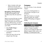
... of the map. eTrex Owner's Manual 17 Select Profile Change > Automotive. 2. Navigation Compass The eTrex 30x has a 3-axis, electronic compass. Before you must also purchase and install the mount in the text bar along the top of the screen shows information about the selected location. Use the map to navigate to use the map, you can use a bearing pointer or a course pointer to navigate to your vehicle. 1. To improve heading accuracy, do not stand near objects that influence magnetic fields, such...
... of the map. eTrex Owner's Manual 17 Select Profile Change > Automotive. 2. Navigation Compass The eTrex 30x has a 3-axis, electronic compass. Before you must also purchase and install the mount in the text bar along the top of the screen shows information about the selected location. Use the map to navigate to use the map, you can use a bearing pointer or a course pointer to navigate to your vehicle. 1. To improve heading accuracy, do not stand near objects that influence magnetic fields, such...
Owners Manual
Page 19
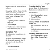
...18). Select Compass. 3. Use the course pointer to navigate to a destination (page 16). 2. Elevation Plot Elevation plotting is available on the plot. Select Elevation Plot > menu > Change Plot Type. 2. Resetting the Elevation Plot Select Elevation Plot > menu > Reset > Clear Current Track > Yes. Select an option. By default, the elevation plot displays the elevation for an elapsed time. Details about a Point on the Plot Select an individual point on the eTrex 30x. eTrex Owner's Manual 19 To customize the elevation plot, see page 34. Navigation Changing the Plot Type You...
...18). Select Compass. 3. Use the course pointer to navigate to a destination (page 16). 2. Elevation Plot Elevation plotting is available on the plot. Select Elevation Plot > menu > Change Plot Type. 2. Resetting the Elevation Plot Select Elevation Plot > menu > Reset > Clear Current Track > Yes. Select an option. By default, the elevation plot displays the elevation for an elapsed time. Details about a Point on the Plot Select an individual point on the eTrex 30x. eTrex Owner's Manual 19 To customize the elevation plot, see page 34. Navigation Changing the Plot Type You...
Owners Manual
Page 24
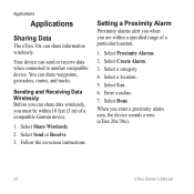
...on-screen instructions. Select Use. 6. Enter a radius. 7. Select Create Alarm. 3. Select Proximity Alarms. 2. Sending and Receiving Data Wirelessly Before you must be within a specified range of a compatible Garmin device. 1. Setting a Proximity Alarm Proximity alarms alert you when you enter a proximity alarm area, the device sounds a tone (eTrex 20x/30x). 24 eTrex Owner's Manual You can share information wirelessly. Select Done. Select a category. 4. Select Send or Receive. 3. Applications Applications Sharing Data The eTrex 30x can share waypoints, geocaches, routes...
...on-screen instructions. Select Use. 6. Enter a radius. 7. Select Create Alarm. 3. Select Proximity Alarms. 2. Sending and Receiving Data Wirelessly Before you must be within a specified range of a compatible Garmin device. 1. Setting a Proximity Alarm Proximity alarms alert you when you enter a proximity alarm area, the device sounds a tone (eTrex 20x/30x). 24 eTrex Owner's Manual You can share information wirelessly. Select Done. Select a category. 4. Select Send or Receive. 3. Applications Applications Sharing Data The eTrex 30x can share waypoints, geocaches, routes...
Owners Manual
Page 26
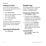
...on at the alarm time, the device turns on and sounds the alarm. Select Alarm Clock. 2. Select Satellite > menu. 2. Select Turn Alarm On. 4. Opening the Stopwatch Select Stopwatch. Applications Setting an Alarm If you are not currently using the device, you can set the time, and select Done. 3. Changing the Satellite View 1. Select the clock numbers to set the device to be oriented with your current location, GPS accuracy, satellite locations, and signal strength. Turning Off GPS Select Satellite > menu > Use With GPS Off. 26 eTrex Owner's Manual The alarm sounds at the...
...on at the alarm time, the device turns on and sounds the alarm. Select Alarm Clock. 2. Select Satellite > menu. 2. Select Turn Alarm On. 4. Opening the Stopwatch Select Stopwatch. Applications Setting an Alarm If you are not currently using the device, you can set the time, and select Done. 3. Changing the Satellite View 1. Select the clock numbers to set the device to be oriented with your current location, GPS accuracy, satellite locations, and signal strength. Turning Off GPS Select Satellite > menu > Use With GPS Off. 26 eTrex Owner's Manual The alarm sounds at the...
Owners Manual
Page 28
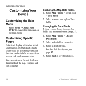
... menu > Setup Map > Data Fields. 2. Select a data field to a specific or general task, such as geocaching. Dashboards are a custom grouping of data fields. Select back to change the map data fields, you can customize the data fields and dashboards of the map, compass, and trip computer. Customizing Specific Pages Data fields display information about your location or other specified data. Select Map > menu > Change Data Fields. 2. Customizing Your Device Customizing Your Device Customizing the Main Menu Select menu > Change Item Order to save the changes. 28 eTrex Owner's Manual...
... menu > Setup Map > Data Fields. 2. Select a data field to a specific or general task, such as geocaching. Dashboards are a custom grouping of data fields. Select back to change the map data fields, you can customize the data fields and dashboards of the map, compass, and trip computer. Customizing Specific Pages Data fields display information about your location or other specified data. Select Map > menu > Change Data Fields. 2. Customizing Your Device Customizing Your Device Customizing the Main Menu Select menu > Change Item Order to save the changes. 28 eTrex Owner's Manual...
Owners Manual
Page 30
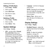
... change the language of time before the backlight turns off ). Note: To adjust the backlight brightness, see page 40. • Colors (eTrex 20x/30x)-sets the colors that display in Night and Day mode. ◦ ◦ Mode-sets a light background (Day), a dark background 30 eTrex Owner's Manual Select Edit Name. 4. Select Done. Deleting a Profile 1. Display Settings Select Setup > Display. • Backlight Timeout-adjusts the length of user-entered data or map data, such as street names. • Battery Type-allows you are using. Select a profile. 3. Customizing Your Device Editing...
... change the language of time before the backlight turns off ). Note: To adjust the backlight brightness, see page 40. • Colors (eTrex 20x/30x)-sets the colors that display in Night and Day mode. ◦ ◦ Mode-sets a light background (Day), a dark background 30 eTrex Owner's Manual Select Edit Name. 4. Select Done. Deleting a Profile 1. Display Settings Select Setup > Display. • Backlight Timeout-adjusts the length of user-entered data or map data, such as street names. • Battery Type-allows you are using. Select a profile. 3. Customizing Your Device Editing...

Owners Manual
Page 33
...Units. 2. Customizing Your Device Time Settings Select Setup > Time. • Time Format-allows you to select a 12-hour or a 24-hour display time. • Time Zone-allows you are saved and cleared automatically based on the user setting. • Color (eTrex 20x/30x)-changes the color of measure for distance and speed, elevation, and pressure. 1. Select a unit of measure for the device. Position Format Settings Note: Do not change the position format or the map datum coordinate system unless you to select the time zone for the setting. eTrex Owner's Manual 33 Tracks are using...
...Units. 2. Customizing Your Device Time Settings Select Setup > Time. • Time Format-allows you to select a 12-hour or a 24-hour display time. • Time Zone-allows you are saved and cleared automatically based on the user setting. • Color (eTrex 20x/30x)-changes the color of measure for distance and speed, elevation, and pressure. 1. Select a unit of measure for the device. Position Format Settings Note: Do not change the position format or the map datum coordinate system unless you to select the time zone for the setting. eTrex Owner's Manual 33 Tracks are using...
Owners Manual
Page 34
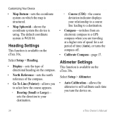
...; Map Spheroid-shows the coordinate system the device is using. Customizing Your Device • Map Datum-sets the coordinate system on the eTrex 30x. The default coordinate system is available on the compass. • North Reference-sets the north reference of the compass. • Go To Line (Pointer)-allows you to self-calibrate each time you are traveling at a higher rate of speed for a set period of directional heading on the eTrex 30x. Select Setup > Altimeter. • Auto Calibration-allows the altimeter to select how the course...
...; Map Spheroid-shows the coordinate system the device is using. Customizing Your Device • Map Datum-sets the coordinate system on the eTrex 30x. The default coordinate system is available on the compass. • North Reference-sets the north reference of the compass. • Go To Line (Pointer)-allows you to self-calibrate each time you are traveling at a higher rate of speed for a set period of directional heading on the eTrex 30x. Select Setup > Altimeter. • Auto Calibration-allows the altimeter to select how the course...
Owners Manual
Page 36
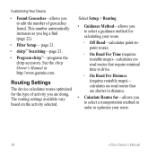
... Road-calculates point-topoint routes. ◦ ◦ On Road For Time (requires routable maps)-calculates onroad routes that are doing. See the chirp Owner's Manual at http://www.garmin.com. The routing settings available vary based on -road routes that require minimal time to edit the number of activity you are shorter in distance. • Calculate Routes for calculating your route. 36 eTrex Owner's Manual Customizing Your Device • Found Geocaches-allows you...
... Road-calculates point-topoint routes. ◦ ◦ On Road For Time (requires routable maps)-calculates onroad routes that are doing. See the chirp Owner's Manual at http://www.garmin.com. The routing settings available vary based on -road routes that require minimal time to edit the number of activity you are shorter in distance. • Calculate Routes for calculating your route. 36 eTrex Owner's Manual Customizing Your Device • Found Geocaches-allows you...
Owners Manual
Page 43
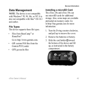
... NT. File Types The device supports these file types. • Files from the Garmin POI Loader • GPX geocache files Device Information Installing a microSD Card The eTrex 20x and eTrex 30x can use microSD cards for more information. 1. Also, some maps are available preloaded on memory cards. It is not compatible with Mac® OS 10.3 and earlier. Turn the D-ring counter-clockwise, and pull up , as instructed in the battery compartment. ➊➋ eTrex Owner's Manual 43 Remove the batteries or battery. 3.
... NT. File Types The device supports these file types. • Files from the Garmin POI Loader • GPX geocache files Device Information Installing a microSD Card The eTrex 20x and eTrex 30x can use microSD cards for more information. 1. Also, some maps are available preloaded on memory cards. It is not compatible with Mac® OS 10.3 and earlier. Turn the D-ring counter-clockwise, and pull up , as instructed in the battery compartment. ➊➋ eTrex Owner's Manual 43 Remove the batteries or battery. 3.
Owners Manual
Page 54
... 41 information 7, 41 installing 7 life 41 long term storage 42 maximizing life 41 selecting the type 7 storage 7 warnings 7 BirdsEye satellite imagery 11 BlueChart g2 maps 11 54 C calculator 25 calendar 25 calibrating altimeter 20 compass 17 caring for the device 42 long-term storage 42 chirp 23 City Navigator maps 17 compass 17 calibrating 17 navigating 18 restore 39 setup options 34 connecting to another device 24 USB cable 44 wireless accessories 46 course pointer 19 creating routes 12 waypoints 9 customizing eTrex Owner's Manual
... 41 information 7, 41 installing 7 life 41 long term storage 42 maximizing life 41 selecting the type 7 storage 7 warnings 7 BirdsEye satellite imagery 11 BlueChart g2 maps 11 54 C calculator 25 calendar 25 calibrating altimeter 20 compass 17 caring for the device 42 long-term storage 42 chirp 23 City Navigator maps 17 compass 17 calibrating 17 navigating 18 restore 39 setup options 34 connecting to another device 24 USB cable 44 wireless accessories 46 course pointer 19 creating routes 12 waypoints 9 customizing eTrex Owner's Manual
Owners Manual
Page 55
... E editing profiles 30 routes 12 eTrex Owner's Manual waypoints 9 elevation plot 19, 20 barometric altimeter 20 of a track 15 F file types 43 finding addresses 12 near your location 11 fishing times 25 fitness options 46 G geocaches 21, 35 downloading 21 filter list 21 logging attempt 22 navigating to 22 settings 35 GPS signals 8, 26, 30, 47, 49, 52 turning off 26 Index H heading settings 34 HomePort 43 hunting times 25 K keys 5, 6 L language 30 locking ring 6 M main menu customizing...
... E editing profiles 30 routes 12 eTrex Owner's Manual waypoints 9 elevation plot 19, 20 barometric altimeter 20 of a track 15 F file types 43 finding addresses 12 near your location 11 fishing times 25 fitness options 46 G geocaches 21, 35 downloading 21 filter list 21 logging attempt 22 navigating to 22 settings 35 GPS signals 8, 26, 30, 47, 49, 52 turning off 26 Index H heading settings 34 HomePort 43 hunting times 25 K keys 5, 6 L language 30 locking ring 6 M main menu customizing...
Owners Manual
Page 56
... 8 N navigating 16 driving routes 17 to a geocache 22 to waypoints 9 with bearing pointer 18 with course pointer 19 north up 31 O orientation, map 31 P pages 39 adding 39 removing 39 position format 33 power key 8 profiles 29 changing 29 56 creating 29 selecting 29 proximity alarms 24 R recording tracks 14, 32 registering your device 8 resetting all settings 52 data 38 device 52 elevation plot 19 restoring default settings 39 routes 12-13 active route 13 avoidance 37 creating 12 deleting 13 editing 13 navigating 13 settings 36 S satellite signals...
... 8 N navigating 16 driving routes 17 to a geocache 22 to waypoints 9 with bearing pointer 18 with course pointer 19 north up 31 O orientation, map 31 P pages 39 adding 39 removing 39 position format 33 power key 8 profiles 29 changing 29 56 creating 29 selecting 29 proximity alarms 24 R recording tracks 14, 32 registering your device 8 resetting all settings 52 data 38 device 52 elevation plot 19 restoring default settings 39 routes 12-13 active route 13 avoidance 37 creating 12 deleting 13 editing 13 navigating 13 settings 36 S satellite signals...


