Pilot's Guide
Page 6
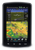
...range weather avoidance. Pilots using any outdated database do so entirely at their own risk. Weather information is obtained from the responsibility of being aware of view or interfere with operating controls. Garmin aera 795/796 Pilot's Guide 190-01194-00 Rev. ...be updated regularly in order to inherent delays in applications requiring a certified terrain awareness system. Terrain data is approved only for long-range planning purposes only. Databases used for appropriate minimum clearance altitudes. WARNING: The altitude calculated by aera 795/796 GPS...
...range weather avoidance. Pilots using any outdated database do so entirely at their own risk. Weather information is obtained from the responsibility of being aware of view or interfere with operating controls. Garmin aera 795/796 Pilot's Guide 190-01194-00 Rev. ...be updated regularly in order to inherent delays in applications requiring a certified terrain awareness system. Terrain data is approved only for long-range planning purposes only. Databases used for appropriate minimum clearance altitudes. WARNING: The altitude calculated by aera 795/796 GPS...
Pilot's Guide
Page 9
... from GPS repeaters operating inside nearby hangars can cause an intermittent loss of the aera 795/796 panel and displays, are subject to change and may not reflect the most current aera 795/796 system and aviation databases. NOTE: Use of normal business hours. NOTE: Temporary Flight Restriction (TFR) ...the condition. This notice is provided by the FAA and may not be updated outside of polarized eyewear may differ slightly from the source of California to our web site at www.garmin.com/prop65. A Garmin aera 795/796 Pilot's Guide Depictions of TFR data. 190-01194-00 Rev.
... from GPS repeaters operating inside nearby hangars can cause an intermittent loss of the aera 795/796 panel and displays, are subject to change and may not reflect the most current aera 795/796 system and aviation databases. NOTE: Use of normal business hours. NOTE: Temporary Flight Restriction (TFR) ...the condition. This notice is provided by the FAA and may not be updated outside of polarized eyewear may differ slightly from the source of California to our web site at www.garmin.com/prop65. A Garmin aera 795/796 Pilot's Guide Depictions of TFR data. 190-01194-00 Rev.

Pilot's Guide
Page 79
...aera 795/796 automatically updates the information if the procedure has not been modified. When storing flight plans with an approach, the aera 795/796 uses the waypoint information from the affected stored flight plan(s), and an alert is turned off. If an approach is no longer available, the procedure is deleted from the current database... an approach is loaded into the active flight plan it replaces the destination airport with up to define the waypoints. A Garmin aera 795/796 Pilot's Guide 65 One flight plan can be activated at a time and inserting approaches as needed.
...aera 795/796 automatically updates the information if the procedure has not been modified. When storing flight plans with an approach, the aera 795/796 uses the waypoint information from the affected stored flight plan(s), and an alert is turned off. If an approach is no longer available, the procedure is deleted from the current database... an approach is loaded into the active flight plan it replaces the destination airport with up to define the waypoints. A Garmin aera 795/796 Pilot's Guide 65 One flight plan can be activated at a time and inserting approaches as needed.

Pilot's Guide
Page 99
... an international code used for reporting weather observations. If METAR data is shown next to the airport. A Garmin aera 795/796 Pilot's Guide 85 METARs typically contain information about the temperature, dewpoint, wind, precipitation, cloud cover, cloud ... expected changes in weather conditions. TAFs may contain some of the same code as needed. METARs are updated hourly or as METAR data. Touching the Map Feature Button will display additional information. An abbreviated version ... Report) is only displayed within the installed aviation database service area.
... an international code used for reporting weather observations. If METAR data is shown next to the airport. A Garmin aera 795/796 Pilot's Guide 85 METARs typically contain information about the temperature, dewpoint, wind, precipitation, cloud cover, cloud ... expected changes in weather conditions. TAFs may contain some of the same code as needed. METARs are updated hourly or as METAR data. Touching the Map Feature Button will display additional information. An abbreviated version ... Report) is only displayed within the installed aviation database service area.

Pilot's Guide
Page 133
... for information about SiriusXM Weather products. Based on the aera 795/796, the database initialization indicates whether the databases are subscription-based. A Garmin aera 795/796 Pilot's Guide 119 Index SafeTaxi is revised every 56 days. NOTE: Refer to constantly search for instructions on updating the SafeTaxi database. 5.7 SiriusXM® RADIO (aera 796) Flight Planning Hazard Avoidance Additional Features Appendices NOTE...
... for information about SiriusXM Weather products. Based on the aera 795/796, the database initialization indicates whether the databases are subscription-based. A Garmin aera 795/796 Pilot's Guide 119 Index SafeTaxi is revised every 56 days. NOTE: Refer to constantly search for instructions on updating the SafeTaxi database. 5.7 SiriusXM® RADIO (aera 796) Flight Planning Hazard Avoidance Additional Features Appendices NOTE...

Pilot's Guide
Page 150
... therefore may not be contained in the obstacle database. It is updated on a 56-day cycle. 136 Garmin aera 795/796 Pilot's Guide 190-01194-00 Rev. This database is no set schedule. There is updated on a 28-day cycle. This database is updated on a 56-day cycle. SafeTaxi The SafeTaxi database contains detailed airport diagrams for the United States...
... therefore may not be contained in the obstacle database. It is updated on a 56-day cycle. 136 Garmin aera 795/796 Pilot's Guide 190-01194-00 Rev. This database is no set schedule. There is updated on a 28-day cycle. This database is updated on a 56-day cycle. SafeTaxi The SafeTaxi database contains detailed airport diagrams for the United States...
Pilot's Guide
Page 151
.../country, location (latitude/longitude), and frequency. 190-01194-00 Rev. The terrain database is provided from government agencies. A Garmin aera 795/796 Pilot's Guide 137 Appendices Index Garmin Aviation Database Updates The Garmin aviation database updates can be downloaded directly to the PC's USB port. Updates to the Jeppesen database are initialized and displayed on Windows®-compatible PCs and requires the...
.../country, location (latitude/longitude), and frequency. 190-01194-00 Rev. The terrain database is provided from government agencies. A Garmin aera 795/796 Pilot's Guide 137 Appendices Index Garmin Aviation Database Updates The Garmin aviation database updates can be downloaded directly to the PC's USB port. Updates to the Jeppesen database are initialized and displayed on Windows®-compatible PCs and requires the...
Pilot's Guide
Page 152
ChartView ChartView database is locked and unusable. Additional Features Hazard Avoidance Flight Planning Appendices Index 138 Garmin aera 795/796 Pilot's Guide 190-01194-00 Rev. ChartView is disabled 70 days after the expiration date and is no longer available for NDBs...point in a saved route, the route is revised every 14 days. A new route with those used for viewing. NOTE: After performing a Jeppesen database update, verify all flight plan (routes) are still viewable during a period that extends from the cycle expiration date to be created. ChartView data is ...
ChartView ChartView database is locked and unusable. Additional Features Hazard Avoidance Flight Planning Appendices Index 138 Garmin aera 795/796 Pilot's Guide 190-01194-00 Rev. ChartView is disabled 70 days after the expiration date and is no longer available for NDBs...point in a saved route, the route is revised every 14 days. A new route with those used for viewing. NOTE: After performing a Jeppesen database update, verify all flight plan (routes) are still viewable during a period that extends from the cycle expiration date to be created. ChartView data is ...
Quick Reference Guide
Page 5
... and does not relieve the pilot from third party sources. Databases used for use of the terrain data. B Garmin aera 795/796 Quick Reference Guide Warnings, Cautions & Notes WARNING: When installing the aera™ 795/796, place the unit so it does not obstruct the field ...when determining or selecting aircraft altitude. WARNING: Do not use pressure altitude displayed by pressure altimeters. The aera 795/796 Terrain Proximity feature is to be updated regularly in applications requiring a certified terrain awareness system. Terrain data is not able to ensure that the ...
... and does not relieve the pilot from third party sources. Databases used for use of the terrain data. B Garmin aera 795/796 Quick Reference Guide Warnings, Cautions & Notes WARNING: When installing the aera™ 795/796, place the unit so it does not obstruct the field ...when determining or selecting aircraft altitude. WARNING: Do not use pressure altitude displayed by pressure altimeters. The aera 795/796 Terrain Proximity feature is to be updated regularly in applications requiring a certified terrain awareness system. Terrain data is not able to ensure that the ...
Quick Reference Guide
Page 8
NOTE: Use of polarized eyewear may not reflect the most current aera 795/796 system and aviation databases. NOTE: Temporary Flight Restriction (TFR) data is being provided in accordance with California's Proposition 65. This notice is provided by the FAA and may differ...to change and may cause the flight displays to appear dim or blank. Depictions of equipment may not be updated outside of California to our web site at www.garmin.com/prop65. Garmin aera 795/796 Quick Reference Guide 190-01194-01 Rev. If you have any questions or would like additional information, please refer...
NOTE: Use of polarized eyewear may not reflect the most current aera 795/796 system and aviation databases. NOTE: Temporary Flight Restriction (TFR) data is being provided in accordance with California's Proposition 65. This notice is provided by the FAA and may differ...to change and may cause the flight displays to appear dim or blank. Depictions of equipment may not be updated outside of California to our web site at www.garmin.com/prop65. Garmin aera 795/796 Quick Reference Guide 190-01194-01 Rev. If you have any questions or would like additional information, please refer...


