
Owner's Manual
Page 1
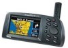
StreetPilot™ III portable GPS with auto-routing and voice owner's manual and reference guide
StreetPilot™ III portable GPS with auto-routing and voice owner's manual and reference guide

Owner's Manual
Page 3
...maps is organized into the power adapter cable. For more detailed information regarding GPS, we have prepared a booklet called "GPS Guide for Global Positioning System, a group of arrival at your intended ...StreetPilot III offers true turn-by -turn navigation with the basic features of contents. Along the way, the StreetPilot III provides automated voice prompts, alerting you to necessary turns, distance to upcoming turns, route deviation, and distance to find your precise location. The StreetPilot III is built into three sections for choosing the Garmin StreetPilot III...
...maps is organized into the power adapter cable. For more detailed information regarding GPS, we have prepared a booklet called "GPS Guide for Global Positioning System, a group of arrival at your intended ...StreetPilot III offers true turn-by -turn navigation with the basic features of contents. Along the way, the StreetPilot III provides automated voice prompts, alerting you to necessary turns, distance to upcoming turns, route deviation, and distance to find your precise location. The StreetPilot III is built into three sections for choosing the Garmin StreetPilot III...

Owner's Manual
Page 4
... 30 Finding an Address or an Intersection . . . 31 Recently Found Places 32 Using the Routes Menu 32 Deleting and Renaming Routes 36 Main Menu 36 GPS Information Page 37 Sky View and Signal Strength Bars . . . . 37 Receiver Status 38 'Poor Satellite Reception' Menu 39 Accuracy 39... GPS Information Page Options 40 Map Source Information Page 41 System Information Page 41 System Setup Pages 41 'General' Tab 43 'Guidance' Tab 44 'Routing' Tab ...
... 30 Finding an Address or an Intersection . . . 31 Recently Found Places 32 Using the Routes Menu 32 Deleting and Renaming Routes 36 Main Menu 36 GPS Information Page 37 Sky View and Signal Strength Bars . . . . 37 Receiver Status 38 'Poor Satellite Reception' Menu 39 Accuracy 39... GPS Information Page Options 40 Map Source Information Page 41 System Information Page 41 System Setup Pages 41 'General' Tab 43 'Guidance' Tab 44 'Routing' Tab ...

Owner's Manual
Page 6
...will not interfere with a 'Safe Mode' feature to improve driver safety. It is unsafe to operate the controls of the StreetPilot III to place and secure the GPS unit so that can be turned off to allow a passenger to airbag safety precautions contained in the field of an... accident. WARNING: For use while driving. Do not mount the StreetPilot III in the event of airbag deployment. Refer to operate the unit. The mounting hardware provided by Garmin...
...will not interfere with a 'Safe Mode' feature to improve driver safety. It is unsafe to operate the controls of the StreetPilot III to place and secure the GPS unit so that can be turned off to allow a passenger to airbag safety precautions contained in the field of an... accident. WARNING: For use while driving. Do not mount the StreetPilot III in the event of airbag deployment. Refer to operate the unit. The mounting hardware provided by Garmin...

Owner's Manual
Page 7
...GPS) is operated by the government of the United States, which we identify as required in accordance with California's Proposition 65. The system is subject to changes that is available to us at times to cause cancer, birth defects, or reproductive harm. Although the StreetPilot III... could affect the accuracy and performance of Garmin is a precision NAVigation AID (NAVAID), any discrepancies before continuing navigation. MAP DATA INFORMATION: One of the goals of all available navigation sources, including the information from the StreetPilot III to the consumer. We use . THIS...
...GPS) is operated by the government of the United States, which we identify as required in accordance with California's Proposition 65. The system is subject to changes that is available to us at times to cause cancer, birth defects, or reproductive harm. Although the StreetPilot III... could affect the accuracy and performance of Garmin is a precision NAVigation AID (NAVAID), any discrepancies before continuing navigation. MAP DATA INFORMATION: One of the goals of all available navigation sources, including the information from the StreetPilot III to the consumer. We use . THIS...

Owner's Manual
Page 12
... rechargeable, Lithium, or Ni-Cad batteries can use of the power symbol a green battery strength bar indicator appears (see page 43, under 'GPS Mode') or you replace the batteries. , WARNING: It is low' message appears at the bottom of the unit. Turn the D-ring &#...Alkaline batteries with the proper polarity, positive (+) or negative (-), orientation as indicated in place. Introduction Installing the Batteries Battery Installation The StreetPilot III uses six (6) AA batteries, which are installed at the back of the page. Batteries can leak and cause personal injury and property ...
... rechargeable, Lithium, or Ni-Cad batteries can use of the power symbol a green battery strength bar indicator appears (see page 43, under 'GPS Mode') or you replace the batteries. , WARNING: It is low' message appears at the bottom of the unit. Turn the D-ring &#...Alkaline batteries with the proper polarity, positive (+) or negative (-), orientation as indicated in place. Introduction Installing the Batteries Battery Installation The StreetPilot III uses six (6) AA batteries, which are installed at the back of the page. Batteries can leak and cause personal injury and property ...

Owner's Manual
Page 16
When you are not driving on the Map page: Current Direction (N, S, E, or W) - The StreetPilot III uses both map resolution and GPS accuracy in text format only when you are traveling when not navigating a route. Map Page Navigation Information The following navigation information can ...hour. More detailed map features as well as information about those features can be displayed using a data card containing map data transferred from a Garmin MapSource CDROM. Driving Instructions - Your rate of travel which can be displayed in miles per hour or kilometers per hour. Reference Map Page...
When you are not driving on the Map page: Current Direction (N, S, E, or W) - The StreetPilot III uses both map resolution and GPS accuracy in text format only when you are traveling when not navigating a route. Map Page Navigation Information The following navigation information can ...hour. More detailed map features as well as information about those features can be displayed using a data card containing map data transferred from a Garmin MapSource CDROM. Driving Instructions - Your rate of travel which can be displayed in miles per hour or kilometers per hour. Reference Map Page...

Owner's Manual
Page 38
... the ROCKER KEYPAD and enter the new route name. Display various system setup functions. Reference Using the Routes Menu / Main Menu The StreetPilot III allows you may view the following: GPS Info page - Select 'Yes' in the confirmation window and press ENTER again. Main Menu Pressing the MENU key twice will...
... the ROCKER KEYPAD and enter the new route name. Display various system setup functions. Reference Using the Routes Menu / Main Menu The StreetPilot III allows you may view the following: GPS Info page - Select 'Yes' in the confirmation window and press ENTER again. Main Menu Pressing the MENU key twice will...
Owner's Manual
Page 39
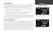
... GPS Information Page A hollow bar (number 17) indicates the receiver has found the satellite and is collecting data. • Solid signal strength bar: the receiver has collected the necessary data and the satellite(s) is ready for navigation (solid signal strength bar). As the StreetPilot III ... ) before that must be collected (hollow signal strength bar, as described above the horizon. Once a fix has been calculated, the StreetPilot III will appear for each satellite position relative to a 'Track Up' instead of 'North Up' configuration (under the 'Orientation' fi...
... GPS Information Page A hollow bar (number 17) indicates the receiver has found the satellite and is collecting data. • Solid signal strength bar: the receiver has collected the necessary data and the satellite(s) is ready for navigation (solid signal strength bar). As the StreetPilot III ... ) before that must be collected (hollow signal strength bar, as described above the horizon. Once a fix has been calculated, the StreetPilot III will appear for each satellite position relative to a 'Track Up' instead of 'North Up' configuration (under the 'Orientation' fi...

Owner's Manual
Page 40
...battery life is saved since the GPS receiver is turned off and back on the satellites currently in latitude, longitude and elevation. '3D Diff' will appear when you may need to a shaded antenna (driving between buildings, etc.) Not Usable - The StreetPilot III is Off - The receiver ... can take up to five minutes, depending on to reset and re-initialize the receiver if necessary. GPS is initializing and collecting new almanac data. The StreetPilot III is being calculated in view. The receiver isn't tracking enough satellites for '2D', you are receiving DGPS corrections...
...battery life is saved since the GPS receiver is turned off and back on the satellites currently in latitude, longitude and elevation. '3D Diff' will appear when you may need to a shaded antenna (driving between buildings, etc.) Not Usable - The StreetPilot III is Off - The receiver ... can take up to five minutes, depending on to reset and re-initialize the receiver if necessary. GPS is initializing and collecting new almanac data. The StreetPilot III is being calculated in view. The receiver isn't tracking enough satellites for '2D', you are receiving DGPS corrections...

Owner's Manual
Page 41
.... Updating your approximate location will tell the unit to search for your current location and date on the satellite skyview are for the StreetPilot III performance specifications which include accuracy. 'Poor Satellite Reception' Menu If no satellites are received for several options when an insuf&#... useful if you have traveled over 500 miles with the unit turned off the GPS for the correct satellites and is used indoors. See Appendix I (pages 67-68) for reference (notice that the StreetPilot III is searching for indoor use your approximate location or turn off . If the ...
.... Updating your approximate location will tell the unit to search for your current location and date on the satellite skyview are for the StreetPilot III performance specifications which include accuracy. 'Poor Satellite Reception' Menu If no satellites are received for several options when an insuf&#... useful if you have traveled over 500 miles with the unit turned off the GPS for the correct satellites and is used indoors. See Appendix I (pages 67-68) for reference (notice that the StreetPilot III is searching for indoor use your approximate location or turn off . If the ...

Owner's Manual
Page 42
Reference GPS Information Page Options Selecting 'North Up' will attempt to use the last known elevation. Selecting 'Track Up' will automatically rotate the sky view to determine its position. Use the ROCKER KEYPAD to highlight 'New Location' and press ENTER. In such instances, without initialization, the StreetPilot III may be looking for any available...
Reference GPS Information Page Options Selecting 'North Up' will attempt to use the last known elevation. Selecting 'Track Up' will automatically rotate the sky view to determine its position. Use the ROCKER KEYPAD to highlight 'New Location' and press ENTER. In such instances, without initialization, the StreetPilot III may be looking for any available...

Owner's Manual
Page 43
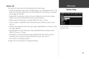
A box appears to the left of available maps. 3. If a check mark appears in your StreetPilot III. 2. Select System Setup and press ENTER. The System Information page 41 MapSource data must first be uploaded to a cartridge and installed in the box ... the MENU key twice from the Main menu, then use the ROCKER KEYPAD to perform various System Setup functions. System Setup Pages Much as the GPS Info, MapSource Info and System Info pages, the System Setup pages can be used to scroll through the list of each map name (directly under...
A box appears to the left of available maps. 3. If a check mark appears in your StreetPilot III. 2. Select System Setup and press ENTER. The System Information page 41 MapSource data must first be uploaded to a cartridge and installed in the box ... the MENU key twice from the Main menu, then use the ROCKER KEYPAD to perform various System Setup functions. System Setup Pages Much as the GPS Info, MapSource Info and System Info pages, the System Setup pages can be used to scroll through the list of each map name (directly under...

Owner's Manual
Page 44
... modified. 4. This can completely reset the System Setup features on the screen, select the file tab for other file tabs. GPS Mode, Units, Voice, Battery Type, Attention Tone and Keypress Tone. Use the UP key to return to the file tab area and select another... ROCKER KEYPAD to move the cursor to the file tab for which you may desire to restore the default System Setup settings of the StreetPilot III. At some point in time, you want to restore the original settings. 2. If desired, repeat steps 1 through 3 for the desired function. Reference System Setup ...
... modified. 4. This can completely reset the System Setup features on the screen, select the file tab for other file tabs. GPS Mode, Units, Voice, Battery Type, Attention Tone and Keypress Tone. Use the UP key to return to the file tab area and select another... ROCKER KEYPAD to move the cursor to the file tab for which you may desire to restore the default System Setup settings of the StreetPilot III. At some point in time, you want to restore the original settings. 2. If desired, repeat steps 1 through 3 for the desired function. Reference System Setup ...

Owner's Manual
Page 45
... - Selects desired operating language for each System Setup file tab item. 'General' Tab GPS Mode - Allows you to choose between three operating modes: • Normal: with the GPS receiver On. • Battery Saver: with a less frequent satellite signal updating process to conserve ...right before a turn right". There are starting a new leg: the voice message will be preceded by a lower pitched tone. The StreetPilot III will precede all automatic voice navigation messages (see 'Attention Tone' below). Selects the proper interface format. The 'Use Indoors' option on ...
... - Selects desired operating language for each System Setup file tab item. 'General' Tab GPS Mode - Allows you to choose between three operating modes: • Normal: with the GPS receiver On. • Battery Saver: with a less frequent satellite signal updating process to conserve ...right before a turn right". There are starting a new leg: the voice message will be preceded by a lower pitched tone. The StreetPilot III will precede all automatic voice navigation messages (see 'Attention Tone' below). Selects the proper interface format. The 'Use Indoors' option on ...
Owner's Manual
Page 51
Reference System Setup The StreetPilot III allows you to choose from a Garmin DGPS beacon receiver and automatically ...capabilities. 'Interface' Tab The 'Interface' file tab provides the following input/output format settings: • Garmin: the proprietary format used to receive differential corrections from a number of standard NMEA 0183 version 2.30 data. •...64257;xed-column ASCII output with data for position, track, speed, etc. • RTCM In: allows Differential GPS (DGPS) input using a standard RTCM SC-104 format, without any output capabilities. • RTCM In/NMEA ...
Reference System Setup The StreetPilot III allows you to choose from a Garmin DGPS beacon receiver and automatically ...capabilities. 'Interface' Tab The 'Interface' file tab provides the following input/output format settings: • Garmin: the proprietary format used to receive differential corrections from a number of standard NMEA 0183 version 2.30 data. •...64257;xed-column ASCII output with data for position, track, speed, etc. • RTCM In: allows Differential GPS (DGPS) input using a standard RTCM SC-104 format, without any output capabilities. • RTCM In/NMEA ...

Owner's Manual
Page 53
...unsecured on the vehicle dash Do not mount in the field of airbag deployment. NOTE: An optional external remote antenna (Garmin GA26C) may choose to use in vehicles, it is the sole responsibility of the owner/operator to impact it with consideration ...using a remote antenna, be performed with you once you reach your StreetPilot III. Airbags expand with the StreetPilot III. Vehicle Installation The StreetPilot III is portable, allowing you to easily carry the unit from vehicle to select a location where the GPS unit's antenna has a relatively unobstructed view of the sky. A...
...unsecured on the vehicle dash Do not mount in the field of airbag deployment. NOTE: An optional external remote antenna (Garmin GA26C) may choose to use in vehicles, it is the sole responsibility of the owner/operator to impact it with consideration ...using a remote antenna, be performed with you once you reach your StreetPilot III. Airbags expand with the StreetPilot III. Vehicle Installation The StreetPilot III is portable, allowing you to easily carry the unit from vehicle to select a location where the GPS unit's antenna has a relatively unobstructed view of the sky. A...

Owner's Manual
Page 55
... base and push the top of the GPS unit back into the bracket until fully seated. Installing the GPS Unit into the speaker jack located below the antenna (see figure to the right) and the corresponding notches on the rear of the StreetPilot III (behind the rubber weather cap). The... speaker which is "keyed" with vehicle operation in place. 3. Locate the tabs on the base/top of the GPS unit's case. 2. Locate the power connector on the bottom/top of...
... base and push the top of the GPS unit back into the bracket until fully seated. Installing the GPS Unit into the speaker jack located below the antenna (see figure to the right) and the corresponding notches on the rear of the StreetPilot III (behind the rubber weather cap). The... speaker which is "keyed" with vehicle operation in place. 3. Locate the tabs on the base/top of the GPS unit's case. 2. Locate the power connector on the bottom/top of...
Owner's Manual
Page 58
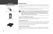
... Parts and Optional Accessories. , WARNING: Garmin accessories have not been tested or approved for use with Garmin products. Use of such accessories could cause damage to enhance the operation of the StreetPilot III. You can block GPS signals. • Programmable Data Cards Additional... data cards are available in 8MB, 16MB, 32MB, 64MB, and 128MB sizes. Contact your Garmin Dealer, Garmin Customer Service in -screen heating system that are compatible with the StreetPilot III and cover...
... Parts and Optional Accessories. , WARNING: Garmin accessories have not been tested or approved for use with Garmin products. Use of such accessories could cause damage to enhance the operation of the StreetPilot III. You can block GPS signals. • Programmable Data Cards Additional... data cards are available in 8MB, 16MB, 32MB, 64MB, and 128MB sizes. Contact your Garmin Dealer, Garmin Customer Service in -screen heating system that are compatible with the StreetPilot III and cover...

Owner's Manual
Page 65
..., move the cursor to quickly download City Navigator maps using a USB programmer can continue to a data card that is also included with the StreetPilot III. Connect the StreetPilot III to your GPS unit! When properly inserted, the cartridge will overwrite previously stored data. For more information, please refer to program your data card is MUCH...
..., move the cursor to quickly download City Navigator maps using a USB programmer can continue to a data card that is also included with the StreetPilot III. Connect the StreetPilot III to your GPS unit! When properly inserted, the cartridge will overwrite previously stored data. For more information, please refer to program your data card is MUCH...

