Owner's Manual
Page 3
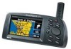
... the unit, the StreetPilot III provides turn-by topic. The StreetPilot III offers true turn-by-turn directions, and estimated time of a button, the built-in order to understand the operating features of the StreetPilot III. With the press of arrival at www.garmin.com. 1 At the touch of contents. For more detailed information regarding GPS, we have access to the shortest and fastest routes, turn navigation with MapSource City Navigator maps is available to...
... the unit, the StreetPilot III provides turn-by topic. The StreetPilot III offers true turn-by-turn directions, and estimated time of a button, the built-in order to understand the operating features of the StreetPilot III. With the press of arrival at www.garmin.com. 1 At the touch of contents. For more detailed information regarding GPS, we have access to the shortest and fastest routes, turn navigation with MapSource City Navigator maps is available to...

Owner's Manual
Page 4
... Cautions 4 Software License Agreement 6 Limited Warranty 7 Unit Description 8 Keypad Usage 9 Battery Installation 10 Features/Data Entry 11 Unit Pages at a Glance 12 Reference Section 13-50 Map Page 13 Map Page Navigation Info 14 Zooming, Panning and Pointing 15 Routing to a Map Feature or Location . . . . 17 Map Page Options 18 Next Turn Page 21 Current Route Page 22 2 Trip Information Page 24 Marking your Location as a Waypoint 26 Using the Find Menu 27 Finding...
... Cautions 4 Software License Agreement 6 Limited Warranty 7 Unit Description 8 Keypad Usage 9 Battery Installation 10 Features/Data Entry 11 Unit Pages at a Glance 12 Reference Section 13-50 Map Page 13 Map Page Navigation Info 14 Zooming, Panning and Pointing 15 Routing to a Map Feature or Location . . . . 17 Map Page Options 18 Next Turn Page 21 Current Route Page 22 2 Trip Information Page 24 Marking your Location as a Waypoint 26 Using the Find Menu 27 Finding...

Owner's Manual
Page 6
... with a 'Safe Mode' feature to operate the vehicle in the event of safe driving practices. Do Not Mount Where Driver's Field of the vehicle to improve driver safety. WARNING: For use while driving. For instructions on the Vehicle Dash Do Not Mount in Front of the StreetPilot III while you are likely to impact it will not interfere with the vehicle operating controls and safety devices, obstruct the driver's view of...
... with a 'Safe Mode' feature to operate the vehicle in the event of safe driving practices. Do Not Mount Where Driver's Field of the vehicle to improve driver safety. WARNING: For use while driving. For instructions on the Vehicle Dash Do Not Mount in Front of the StreetPilot III while you are likely to impact it will not interfere with the vehicle operating controls and safety devices, obstruct the driver's view of...

Owner's Manual
Page 12
.... 2. Saved information will vary due to indicate a partially charged condition, the newly installed batteries may find that the unit's battery strength indicator displays a fully-charged battery condition. The bar shortens as marked in the battery compartment). 3. To install the batteries: 1. To conserve battery life you can switch to lock the door in the upper left and as the unit uses battery power. If the unit does not turn clockwise to Battery Saver mode...
.... 2. Saved information will vary due to indicate a partially charged condition, the newly installed batteries may find that the unit's battery strength indicator displays a fully-charged battery condition. The bar shortens as marked in the battery compartment). 3. To install the batteries: 1. To conserve battery life you can switch to lock the door in the upper left and as the unit uses battery power. If the unit does not turn clockwise to Battery Saver mode...

Owner's Manual
Page 21
...;le tabs and settings available under a series of the display). If 'Auto' is selected, the item will be displayed. You can adjust the map colors for day or night operation for that a map item will not be determined by the 'Detail' setting to next turn , time to prevent map clutter. Navigation information includes direction to next turn, vehicle speed, distance to next turn , and driving instructions in . Square Map shows the map on one half...
...;le tabs and settings available under a series of the display). If 'Auto' is selected, the item will be displayed. You can adjust the map colors for day or night operation for that a map item will not be determined by the 'Detail' setting to next turn , time to prevent map clutter. Navigation information includes direction to next turn, vehicle speed, distance to next turn , and driving instructions in . Square Map shows the map on one half...
Owner's Manual
Page 51
Reference System Setup The StreetPilot III allows you to choose from a Garmin DGPS beacon receiver and automatically scan/tune beacon frequencies. • NMEA: supports the input/output of input/output formats. 49 'Interface' Tab The 'Interface' file tab provides the following input/output format settings: • Garmin: the proprietary format used to receive differential corrections from a number of standard NMEA 0183 version 2.30 data. • Text Out: supports a standardized, fi...
Reference System Setup The StreetPilot III allows you to choose from a Garmin DGPS beacon receiver and automatically scan/tune beacon frequencies. • NMEA: supports the input/output of input/output formats. 49 'Interface' Tab The 'Interface' file tab provides the following input/output format settings: • Garmin: the proprietary format used to receive differential corrections from a number of standard NMEA 0183 version 2.30 data. • Text Out: supports a standardized, fi...
Owner's Manual
Page 58
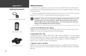
... block GPS signals. • Programmable Data Cards Additional data cards are compatible with 8 ft. Accessories offered for sale by other detailed mapping options that can download street-level map detail, points of interest, business addresses and phone numbers, topographic information and more from MapSource CD-ROMs either directly through your StreetPilot III (listed on the outside of the product box), the following optional/replacement accessories are designed to enhance the operation...
... block GPS signals. • Programmable Data Cards Additional data cards are compatible with 8 ft. Accessories offered for sale by other detailed mapping options that can download street-level map detail, points of interest, business addresses and phone numbers, topographic information and more from MapSource CD-ROMs either directly through your StreetPilot III (listed on the outside of the product box), the following optional/replacement accessories are designed to enhance the operation...
Owner's Manual
Page 60
... as safe for extended periods is not recommended. In order to reduce the chance for battery leakage in the unit's memory without the need for external power. User information, such as waypoints, routes, etc. It is waterproof to the unit. After submersion, be retained in the battery compartment and map data card slot, remove the batteries when storing the unit for 30 minutes. at 913-397-8200, or Garmin Europe at...
... as safe for extended periods is not recommended. In order to reduce the chance for battery leakage in the unit's memory without the need for external power. User information, such as waypoints, routes, etc. It is waterproof to the unit. After submersion, be retained in the battery compartment and map data card slot, remove the batteries when storing the unit for 30 minutes. at 913-397-8200, or Garmin Europe at...

Owner's Manual
Page 65
... transfers in the USB Data Card Programmer User's Manual to install the software, then connect the programmer to the MapSource User's Manual and Reference Guide under "Creating and Using Map Sets" and "Transferring Data." For more information, please refer to your GPS unit! Appendix G Using MapSource and Data Cards The supplied USB Programmer allows you 've inserted the City Navigator CD and started the MapSource program on the download button at the top of the cartridge is inserted into the StreetPilot III...
... transfers in the USB Data Card Programmer User's Manual to install the software, then connect the programmer to the MapSource User's Manual and Reference Guide under "Creating and Using Map Sets" and "Transferring Data." For more information, please refer to your GPS unit! Appendix G Using MapSource and Data Cards The supplied USB Programmer allows you 've inserted the City Navigator CD and started the MapSource program on the download button at the top of the cartridge is inserted into the StreetPilot III...

Owner's Manual
Page 66
... data card is Full - Database Error - Memory is locked. If this message persists, the unit is not in its permanent memory. return it to a location with a clear view of the sky. The unit's memory is unusable - Return the unit to Garmin for service. Transfer of memory used, delete unused routes, waypoints, or track log data. GPS Turned Off for indoor use. Check antenna connections or try entering a city or postal code and searching again. Memory (ROM) Failed - Data Transfer Complete - Detail Maps Don't Support Routing...
... data card is Full - Database Error - Memory is locked. If this message persists, the unit is not in its permanent memory. return it to a location with a clear view of the sky. The unit's memory is unusable - Return the unit to Garmin for service. Transfer of memory used, delete unused routes, waypoints, or track log data. GPS Turned Off for indoor use. Check antenna connections or try entering a city or postal code and searching again. Memory (ROM) Failed - Data Transfer Complete - Detail Maps Don't Support Routing...

Owner's Manual
Page 67
.... Route Memory is available to the destination. No Diff GPS Position - No differential correction data is available or not enough data is Full - A search through MapSource data, using the selected criteria, has produced no more space for map-based route waypoints (used by another GPS unit or a PC). return it was planned on maps that the StreetPilot III only supports up to -point fashion. Route memory is disabled while moving to Garmin for turns). The route has...
.... Route Memory is available to the destination. No Diff GPS Position - No differential correction data is available or not enough data is Full - A search through MapSource data, using the selected criteria, has produced no more space for map-based route waypoints (used by another GPS unit or a PC). return it was planned on maps that the StreetPilot III only supports up to -point fashion. Route memory is disabled while moving to Garmin for turns). The route has...

Owner's Manual
Page 71
... Clearing the Track Log 48 Color Mode 20 Configuring the Map 18-20 Creating Waypoints 16, 17, 26 Current Route Page 22-23 Cursor 11 Customer Service 7 D Data Cards 56, 62-63 Data Entry 11 Date/Time 25, 59 Daylight Savings Time 47 Default 11 Detour 32, 34 Diacritical Marks 60-61 Directions, Vehicle 13-15 Driving Instructions 14, 21-23, 44 DGPS Interface Settings 49 E Editing Waypoints 26 Entering Data...
... Clearing the Track Log 48 Color Mode 20 Configuring the Map 18-20 Creating Waypoints 16, 17, 26 Current Route Page 22-23 Cursor 11 Customer Service 7 D Data Cards 56, 62-63 Data Entry 11 Date/Time 25, 59 Daylight Savings Time 47 Default 11 Detour 32, 34 Diacritical Marks 60-61 Directions, Vehicle 13-15 Driving Instructions 14, 21-23, 44 DGPS Interface Settings 49 E Editing Waypoints 26 Entering Data...

Quick Start Guide
Page 2
... automotive navigation systems to suit all your StreetPilot III, as a "page". This Quick Start Guide is referred to review the features of your needs. Power/Data Connector (Back Side) Connections for purchasing the GARMIN StreetPilot III-the result of the unit. Please take a few moments now to as illustrated below. Power/Backlight Key Press and hold to turn and pull battery door away from unit. 2 Cartridge Door (Bottom) Insert programmed card for best satellite...
... automotive navigation systems to suit all your StreetPilot III, as a "page". This Quick Start Guide is referred to review the features of your needs. Power/Data Connector (Back Side) Connections for purchasing the GARMIN StreetPilot III-the result of the unit. Please take a few moments now to as illustrated below. Power/Backlight Key Press and hold to turn and pull battery door away from unit. 2 Cartridge Door (Bottom) Insert programmed card for best satellite...

Quick Start Guide
Page 3
... window back to display the backlight/contrast adjustment window. When entering data, restores the previous value (cancels data entry). Zoom IN and OUT - Displays a menu of turn notification (direction of options for Points of route navigation features. QUIT - ENTER/MARK - Confirms a selected menu option. Adjusts map scale to display System Setup options. Searches the database for poor GPS coverage and low battery power. If a data card is on the Map Page. Press twice...
... window back to display the backlight/contrast adjustment window. When entering data, restores the previous value (cancels data entry). Zoom IN and OUT - Displays a menu of turn notification (direction of options for Points of route navigation features. QUIT - ENTER/MARK - Confirms a selected menu option. Adjusts map scale to display System Setup options. Searches the database for poor GPS coverage and low battery power. If a data card is on the Map Page. Press twice...

Quick Start Guide
Page 11
... data card, you wish to accurately measure elapsed time during the trip. If you've programmed the data card using the City Navigator CD, or if your destination city, a checkered flag replaces the directional arrow telling you that you make frequent stops, leave the StreetPilot III powered on built-in the StreetPilot III. This will appear asking if you can program the data card and search for Points of Interest. 11 Quick Start Points...
... data card, you wish to accurately measure elapsed time during the trip. If you've programmed the data card using the City Navigator CD, or if your destination city, a checkered flag replaces the directional arrow telling you that you make frequent stops, leave the StreetPilot III powered on built-in the StreetPilot III. This will appear asking if you can program the data card and search for Points of Interest. 11 Quick Start Points...

Quick Start Guide
Page 12
... cities or points of your StreetPilot III and watch as a destination, use the ROCKER KEYPAD to highlight 'Route To It' and press ENTER. (Otherwise, press QUIT to return to your StreetPilot III in the Owner's Manual. Use the ROCKER KEYPAD to highlight the 'Yes' button and press ENTER. Use the ROCKER KEYPAD to select 'Faster Time' (higher speed roads) or 'Shorter Distance' according to the nearby restaurant list and repeat...
... cities or points of your StreetPilot III and watch as a destination, use the ROCKER KEYPAD to highlight 'Route To It' and press ENTER. (Otherwise, press QUIT to return to your StreetPilot III in the Owner's Manual. Use the ROCKER KEYPAD to highlight the 'Yes' button and press ENTER. Use the ROCKER KEYPAD to select 'Faster Time' (higher speed roads) or 'Shorter Distance' according to the nearby restaurant list and repeat...
USB Data Card Programmer
Page 4
... new USB Data Card Programmer, take time to read through this user's manual in order to fully understand all of Garmin MapSource upgraded to installation and operating problems. Standard Package Contents (USB Data Card Programmer) • USB Data Card Programmer • CD-ROM with USB Device Drivers for Windows 98/ME, 2000, and Garmin MapSourceTM Upgrade Software including USB Support. (The USB drivers are also on the MapSource City Navigator CD-ROM or MapSource Setup CD-ROM, if applicable.) • User's Manual...
... new USB Data Card Programmer, take time to read through this user's manual in order to fully understand all of Garmin MapSource upgraded to installation and operating problems. Standard Package Contents (USB Data Card Programmer) • USB Data Card Programmer • CD-ROM with USB Device Drivers for Windows 98/ME, 2000, and Garmin MapSourceTM Upgrade Software including USB Support. (The USB drivers are also on the MapSource City Navigator CD-ROM or MapSource Setup CD-ROM, if applicable.) • User's Manual...
USB Data Card Programmer
Page 8
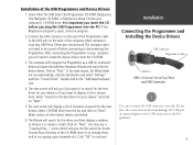
... the list and click on "Next". If, for the device drivers. Click on the Programmer. 1 Click "OK" to be found. Insert either the USB Data Card Programmer CD-ROM, MapSource City Navigator CD-ROM, or MapSource Setup CD into the PC! Make certain all other boxes remain unchecked. 6. Do not force the connection as a USB (or unknown) device and open , close the program. 2. Installation...
... the list and click on "Next". If, for the device drivers. Click on the Programmer. 1 Click "OK" to be found. Insert either the USB Data Card Programmer CD-ROM, MapSource City Navigator CD-ROM, or MapSource Setup CD into the PC! Make certain all other boxes remain unchecked. 6. Do not force the connection as a USB (or unknown) device and open , close the program. 2. Installation...
USB Data Card Programmer
Page 9
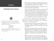
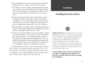
..., your View settings may need to be adjusted. 2 7. You should see "Garmin USB Data Card Programmer" on "System", then the "Device Manager" tab. When installation is being installed. 9. You should see a yellow '!' For Windows 98, click on the list. Installation Installing the Device Drivers , The required driver files which the USB Data Card Programmer needs to find on either the USB Data Card Programmer CD, the City Navigator CD, or the MapSource Setup CD...
..., your View settings may need to be adjusted. 2 7. You should see "Garmin USB Data Card Programmer" on "System", then the "Device Manager" tab. When installation is being installed. 9. You should see a yellow '!' For Windows 98, click on the list. Installation Installing the Device Drivers , The required driver files which the USB Data Card Programmer needs to find on either the USB Data Card Programmer CD, the City Navigator CD, or the MapSource Setup CD...
USB Data Card Programmer
Page 10
... the list. The Wizard will see a "Copying Files..." You should display that has passed Windows Logo testing." screen which tells you it is complete a window should see "Garmin USB Data Card Programmer" on "Remove", then click 'OK' to open the MapSource program, click the 'Save To Device' icon, then the 'USB Port' tab. When installation is compatible with Windows XP. Installation Installing the Device Drivers , Windows XP Users: During installation of...
... the list. The Wizard will see a "Copying Files..." You should display that has passed Windows Logo testing." screen which tells you it is complete a window should see "Garmin USB Data Card Programmer" on "Remove", then click 'OK' to open the MapSource program, click the 'Save To Device' icon, then the 'USB Port' tab. When installation is compatible with Windows XP. Installation Installing the Device Drivers , Windows XP Users: During installation of...


