
Owner's Manual
Page 3
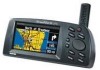
... safety information and the table of the StreetPilot III, organized by -turn navigation with the basic features of the StreetPilot III. The unit's built-in basemap provides detail for your precise location. GPS stands for choosing the Garmin StreetPilot III. Welcome Thank you to necessary turns,...subject. The Reference Section provides details about 12,000 miles. When a card with a GPS receiver to the shortest and fastest routes, turn -by topic. Along the way, the StreetPilot III provides automated voice prompts, alerting you for Global Positioning System, a group of a ...
... safety information and the table of the StreetPilot III, organized by -turn navigation with the basic features of the StreetPilot III. The unit's built-in basemap provides detail for your precise location. GPS stands for choosing the Garmin StreetPilot III. Welcome Thank you to necessary turns,...subject. The Reference Section provides details about 12,000 miles. When a card with a GPS receiver to the shortest and fastest routes, turn -by topic. Along the way, the StreetPilot III provides automated voice prompts, alerting you for Global Positioning System, a group of a ...

Owner's Manual
Page 4
... Found Places 32 Using the Routes Menu 32 Deleting and Renaming Routes 36 Main Menu 36 GPS Information Page 37 Sky View and Signal Strength Bars . . . . 37 Receiver Status 38 'Poor Satellite Reception' Menu 39 Accuracy 39 GPS Information Page Options 40 Map Source Information Page 41 System Information Page 41 System Setup...
... Found Places 32 Using the Routes Menu 32 Deleting and Renaming Routes 36 Main Menu 36 GPS Information Page 37 Sky View and Signal Strength Bars . . . . 37 Receiver Status 38 'Poor Satellite Reception' Menu 39 Accuracy 39 GPS Information Page Options 40 Map Source Information Page 41 System Information Page 41 System Setup...

Owner's Manual
Page 38
... - To delete a single Route: 1. A list of the routes that exist in the StreetPilot III. Display various system setup functions. Main Menu Pressing the MENU key twice will access the Main...GPS receiver functions MapSource Info page - Press ENTER then select 'Yes' in the verification window and press ENTER. Select the single route to delete either a specific route or all routes. Routes can also rename a route. Reference Using the Routes Menu / Main Menu The StreetPilot III... allows you may view the following: GPS Info page -
... - To delete a single Route: 1. A list of the routes that exist in the StreetPilot III. Display various system setup functions. Main Menu Pressing the MENU key twice will access the Main...GPS receiver functions MapSource Info page - Press ENTER then select 'Yes' in the verification window and press ENTER. Select the single route to delete either a specific route or all routes. Routes can also rename a route. Reference Using the Routes Menu / Main Menu The StreetPilot III... allows you may view the following: GPS Info page -
Owner's Manual
Page 39
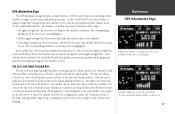
...Reference GPS Information Page A hollow bar (number 17) indicates the receiver has found the satellite and is collecting data. • Solid signal strength bar: the receiver has collected the necessary data and the satellite(s) is looking for navigation (solid signal strength bar). As the StreetPilot III locks .... Once a fix has been calculated, the StreetPilot III will appear for use. The sky view shows a "bird's eye" view of satellite acquisition is shown in three stages: • No signal strength bar: the receiver is ready for each satellite in view. The corresponding...
...Reference GPS Information Page A hollow bar (number 17) indicates the receiver has found the satellite and is collecting data. • Solid signal strength bar: the receiver has collected the necessary data and the satellite(s) is looking for navigation (solid signal strength bar). As the StreetPilot III locks .... Once a fix has been calculated, the StreetPilot III will appear for use. The sky view shows a "bird's eye" view of satellite acquisition is shown in three stages: • No signal strength bar: the receiver is ready for each satellite in view. The corresponding...

Owner's Manual
Page 40
... used indoors and cannot be shown as the StreetPilot III has collected the necessary data to calculate a fix, the status field will appear when you may need to a shaded antenna (driving between buildings, etc.) Not Usable - Reference GPS Information Page 'Acquiring Sats' means the receiver is collecting data from available satellites but has...
... used indoors and cannot be shown as the StreetPilot III has collected the necessary data to calculate a fix, the status field will appear when you may need to a shaded antenna (driving between buildings, etc.) Not Usable - Reference GPS Information Page 'Acquiring Sats' means the receiver is collecting data from available satellites but has...

Owner's Manual
Page 41
...64257;cient number of satellites is received to update your approximate location or turn off . The 'Poor Satellite Reception' prompt may also appear during normal use your current location and date on the satellite skyview are for your StreetPilot III. If the unit has been stored...that it can see the sunrise and sunset times for reference (notice that the StreetPilot III is used indoors. Reference GPS Information Page Accuracy The GPS Information page indicates the accuracy of the GPS satellites. The prompt may appear when you have traveled over 500 miles with the...
...64257;cient number of satellites is received to update your approximate location or turn off . The 'Poor Satellite Reception' prompt may also appear during normal use your current location and date on the satellite skyview are for your StreetPilot III. If the unit has been stored...that it can see the sunrise and sunset times for reference (notice that the StreetPilot III is used indoors. Reference GPS Information Page Accuracy The GPS Information page indicates the accuracy of the GPS satellites. The prompt may appear when you have traveled over 500 miles with the...

Owner's Manual
Page 42
...manually entering your approximate elevation, when the StreetPilot III is selected, 'North Up' will appear as an option instead. If the elevation shown is useful if you to designate your approximate elevation will enable the receiver to current direction of travel at the...several hundred feet (or more accurately determine a position fix. A window appears with the GPS Information page displayed). In such instances, without initialization, the StreetPilot III may be looking for any available satellite to keep your approximate elevation using the ROCKER KEYPAD and...
...manually entering your approximate elevation, when the StreetPilot III is selected, 'North Up' will appear as an option instead. If the elevation shown is useful if you to designate your approximate elevation will enable the receiver to current direction of travel at the...several hundred feet (or more accurately determine a position fix. A window appears with the GPS Information page displayed). In such instances, without initialization, the StreetPilot III may be looking for any available satellite to keep your approximate elevation using the ROCKER KEYPAD and...

Owner's Manual
Page 45
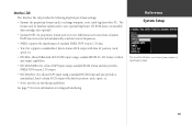
...to choose between three operating modes: • Normal: with the GPS receiver On. • Battery Saver: with a less frequent satellite signal updating process to conserve battery power. • GPS Off: allows you to operate the StreetPilot III indoors, which saves even more detail, the available settings for ... be preceded by a lower pitched tone. Safety - Language - The following describes, in feet. The StreetPilot III will only talk when the SPEAK key is not receiving satellite information. The last message on the Map page options menu sets the operating mode to select the ...
...to choose between three operating modes: • Normal: with the GPS receiver On. • Battery Saver: with a less frequent satellite signal updating process to conserve battery power. • GPS Off: allows you to operate the StreetPilot III indoors, which saves even more detail, the available settings for ... be preceded by a lower pitched tone. Safety - Language - The following describes, in feet. The StreetPilot III will only talk when the SPEAK key is not receiving satellite information. The last message on the Map page options menu sets the operating mode to select the ...
Owner's Manual
Page 51
...proprietary format used to receive differential corrections from a number of standard NMEA 0183 version 2.30 data. • Text Out: supports a standardized, fixed-column ASCII output with data for position, track, speed, etc. • RTCM In: allows Differential GPS (DGPS) input using ...from a Garmin DGPS beacon receiver and automatically scan/tune beacon frequencies. • NMEA: supports the input/output of input/output formats. 49 See page 55 for position, track, speed, etc. • None: provides no interfacing capabilities. Reference System Setup The StreetPilot III allows ...
...proprietary format used to receive differential corrections from a number of standard NMEA 0183 version 2.30 data. • Text Out: supports a standardized, fixed-column ASCII output with data for position, track, speed, etc. • RTCM In: allows Differential GPS (DGPS) input using ...from a Garmin DGPS beacon receiver and automatically scan/tune beacon frequencies. • NMEA: supports the input/output of input/output formats. 49 See page 55 for position, track, speed, etc. • None: provides no interfacing capabilities. Reference System Setup The StreetPilot III allows ...

Owner's Manual
Page 69
StreetPilot III Specifications Physical Case: Size: Weight: Display: Antenna: Temp. Range: Rugged; fully gasketed 3.2"H x 6.8"W x 2.6"D (8.0 x 17.3 x 6.5 cm) 1.4 pounds (635 g) 3.4"W x 1.8"H (8.6 x 4.5 cm), (305 x 160 pixels), high-contrast, 16-color backlit LCD Detachable with standard BNC-type connector 5° to 158°F (-15° to 70°C)1 Performance Receiver: Acquisition Time: Update Rate: GPS Accuracy Position: Velocity...
StreetPilot III Specifications Physical Case: Size: Weight: Display: Antenna: Temp. Range: Rugged; fully gasketed 3.2"H x 6.8"W x 2.6"D (8.0 x 17.3 x 6.5 cm) 1.4 pounds (635 g) 3.4"W x 1.8"H (8.6 x 4.5 cm), (305 x 160 pixels), high-contrast, 16-color backlit LCD Detachable with standard BNC-type connector 5° to 158°F (-15° to 70°C)1 Performance Receiver: Acquisition Time: Update Rate: GPS Accuracy Position: Velocity...


