Owners Manual
Page 3
...Code 3 Monitoring a Channel for Activity 4 Scanning Channels 4 Repeater Channels 4 Peer-to-Peer Positioning 4 Polling Other Rino Users 4 Editing Your Contact Info 4 Contacts 4 Saving a New Contact 4 Viewing Contacts on the Map 4 Navigating to a Contact 4 Notes 4 Creating, Saving, and Sending Notes 4 Emergency Alerts 4 Sending an ...Route 11 Editing a Route 11 Viewing a Route on the Map 11 Deleting a Route 11 Viewing the Active Route 11 Reversing a Route 11 Viewing the Elevation Plot of a Route 11 Garmin Adventures 11 Sending Files to BaseCamp 11 Creating an Adventure ...
...Code 3 Monitoring a Channel for Activity 4 Scanning Channels 4 Repeater Channels 4 Peer-to-Peer Positioning 4 Polling Other Rino Users 4 Editing Your Contact Info 4 Contacts 4 Saving a New Contact 4 Viewing Contacts on the Map 4 Navigating to a Contact 4 Notes 4 Creating, Saving, and Sending Notes 4 Emergency Alerts 4 Sending an ...Route 11 Editing a Route 11 Viewing a Route on the Map 11 Deleting a Route 11 Viewing the Active Route 11 Reversing a Route 11 Viewing the Elevation Plot of a Route 11 Garmin Adventures 11 Sending Files to BaseCamp 11 Creating an Adventure ...
Owners Manual
Page 4
...Notifications 13 Hiding Notifications 13 Fitness 13 History 13 Viewing an Activity History 13 Deleting an Activity from Your History 13 Using Garmin Connect 13 Optional Fitness Accessories 13 About Heart Rate Zones 13 Fitness Goals 13 Setting Your Heart Rate Zones 13 Customizing the... 14 Customizing the Data Fields 14 Customizing Dashboards 14 Setting the Touchscreen Sensitivity 15 Display Settings 15 Configuring the Maps 15 Map Settings 15 Advanced Map Settings 15 System Settings 15 Satellite Settings 15 GPS and GLONASS 15 Appearance Settings 15 Setting the Device Tones ...
...Notifications 13 Hiding Notifications 13 Fitness 13 History 13 Viewing an Activity History 13 Deleting an Activity from Your History 13 Using Garmin Connect 13 Optional Fitness Accessories 13 About Heart Rate Zones 13 Fitness Goals 13 Setting Your Heart Rate Zones 13 Customizing the... 14 Customizing the Data Fields 14 Customizing Dashboards 14 Setting the Touchscreen Sensitivity 15 Display Settings 15 Configuring the Maps 15 Map Settings 15 Advanced Map Settings 15 System Settings 15 Satellite Settings 15 GPS and GLONASS 15 Appearance Settings 15 Setting the Device Tones ...
Owners Manual
Page 5
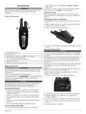
...rating for product warnings and other important information. Introduction 4 Turn the D-ring clockwise to charge a battery that was not provided by Garmin®. When you may exceed the usable range of the batteries. • Reduce the backlight brightness (Adjusting the Backlight Brightness, page ...(Display Settings, page 15). • Use battery save mode (Turning On Battery Save Mode, page 1). • Decrease the map drawing speed (Configuring the Maps, page 15). • Turn off when the backlight times out. NOTE: The device does not charge when outside the approved temperature...
...rating for product warnings and other important information. Introduction 4 Turn the D-ring clockwise to charge a battery that was not provided by Garmin®. When you may exceed the usable range of the batteries. • Reduce the backlight brightness (Adjusting the Backlight Brightness, page ...(Display Settings, page 15). • Use battery save mode (Turning On Battery Save Mode, page 1). • Decrease the map drawing speed (Configuring the Maps, page 15). • Turn off when the backlight times out. NOTE: The device does not charge when outside the approved temperature...
Owners Manual
Page 8
.... Creating, Saving, and Sending Notes 1 From the app drawer, select Notes. TIP: To open the contacts app from other Rino users on the map. You can view location information and navigate to the location of the contact is going out of range. 1 From the radio app... select Send and Save. Through peer-to their locations. From the radio app, select Scan. Position reporting is sent to other Rino users on the Map 1 From the main menu, select Contacts. You can request position updates for your location information to include only specific channels and ...
.... Creating, Saving, and Sending Notes 1 From the app drawer, select Notes. TIP: To open the contacts app from other Rino users on the map. You can view location information and navigate to the location of the contact is going out of range. 1 From the radio app... select Send and Save. Through peer-to their locations. From the radio app, select Scan. Position reporting is sent to other Rino users on the Map 1 From the main menu, select Contacts. You can request position updates for your location information to include only specific channels and ...
Owners Manual
Page 9
...smartphone. Radio Setup From the radio app, select > Radio Setup. VOX Level: Sets the sensitivity of your connections and other Rino users. Software Updates: Allows you transmit to connect a device. You cannot make or receive transmissions when the radio functionality is.../755t device when you to download new data fields that displays the status of a connected Voice Operated Transmission (VOX) accessory. Phone notifications: Displays phone notifications and messages on the map. Activity uploads to Garmin Connect: Automatically sends your Garmin Connect account as soon as...
...smartphone. Radio Setup From the radio app, select > Radio Setup. VOX Level: Sets the sensitivity of your connections and other Rino users. Software Updates: Allows you transmit to connect a device. You cannot make or receive transmissions when the radio functionality is.../755t device when you to download new data fields that displays the status of a connected Voice Operated Transmission (VOX) accessory. Phone notifications: Displays phone notifications and messages on the map. Activity uploads to Garmin Connect: Automatically sends your Garmin Connect account as soon as...
Owners Manual
Page 10
... Hints and Clues to find a Geocache, page 6). To view SAME radio weather alerts on the map, you must remain on the map. • To search for geocaches near your device while connected wirelessly. • Connect to the Garmin Connect app. Weather data is a treasure hunting activity in the county, and you are connected...
... Hints and Clues to find a Geocache, page 6). To view SAME radio weather alerts on the map, you must remain on the map. • To search for geocaches near your device while connected wirelessly. • Connect to the Garmin Connect app. Weather data is a treasure hunting activity in the county, and you are connected...

Owners Manual
Page 12
... > Clear. Clearing the Current Activity You can delete the active activity, you must activate a different activity. Viewing the Elevation Plot of the map. Editing an Activity Name You can create a custom activity with its own unique settings and data fields. 1 From the app drawer, select ...; To record the default recreational activity that creates an optimum representation of the activity line on the map, select Color. • To display a line on the map indicating your activity, select Show On Map. 3 Select > Setup Activities > Record Method. 4 Select an option: • To record ...
... > Clear. Clearing the Current Activity You can delete the active activity, you must activate a different activity. Viewing the Elevation Plot of the map. Editing an Activity Name You can create a custom activity with its own unique settings and data fields. 1 From the app drawer, select ...; To record the default recreational activity that creates an optimum representation of the activity line on the map, select Color. • To display a line on the map indicating your activity, select Show On Map. 3 Select > Setup Activities > Record Method. 4 Select an option: • To record ...
Owners Manual
Page 13
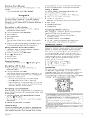
... the Compass, page 9). It can also navigate to photos taken on course. The map displays your Garmin dealer. Course deviation indicator (CDI). Indicates whether you are navigating on the map. Opening Track Manager You can navigate back to the beginning of your activity. Course Pointer...next waypoint. If the CDI is most useful when you go to http://buy.garmin.com or contact your route with location information. Finding an Address You can use additional maps with the Map 1 Begin navigating to a destination (Navigating to view information about the selected location...
... the Compass, page 9). It can also navigate to photos taken on course. The map displays your Garmin dealer. Course deviation indicator (CDI). Indicates whether you are navigating on the map. Opening Track Manager You can navigate back to the beginning of your activity. Course Pointer...next waypoint. If the CDI is most useful when you go to http://buy.garmin.com or contact your route with location information. Finding an Address You can use additional maps with the Map 1 Begin navigating to a destination (Navigating to view information about the selected location...
Owners Manual
Page 14
...Elevation Plot 1 From the app drawer, select Altimeter. 2 Select an individual point on the plot. 3 Select . 4 Select View Map. 5 Navigate using the symbol of waypoints based on -screen instructions. Calibrating the Barometric Altimeter You can manually calibrate the barometric altimeter if...Editing a Waypoint 1 From the app drawer, select Waypoint Manager. 2 Select a saved waypoint. 3 Select an item to search using the map (Navigating with the Map, page 9) or compass (Navigating with the compass direction locked in the device. For example, if you would like to navigate to a location...
...Elevation Plot 1 From the app drawer, select Altimeter. 2 Select an individual point on the plot. 3 Select . 4 Select View Map. 5 Navigate using the symbol of waypoints based on -screen instructions. Calibrating the Barometric Altimeter You can manually calibrate the barometric altimeter if...Editing a Waypoint 1 From the app drawer, select Waypoint Manager. 2 Select a saved waypoint. 3 Select an item to search using the map (Navigating with the Map, page 9) or compass (Navigating with the compass direction locked in the device. For example, if you would like to navigate to a location...
Owners Manual
Page 15
...drawer, select Route Planner. 2 Select a route. 3 Select View Map. Viewing a Route on the map to add to share your device is configured for direct routing, the elevation plot displays the straight-line elevations between route points. Garmin Adventures You can create adventures to the route (optional). 5 Select ...locations that leads you can create an adventure for your latest hiking trip. See your operating system documentation to learn how to map the drive. 3 Open the Garmin or memory card drive or volume. 4 Select an option: • Select an item from a connected device and drag...
...drawer, select Route Planner. 2 Select a route. 3 Select View Map. Viewing a Route on the map to add to share your device is configured for direct routing, the elevation plot displays the straight-line elevations between route points. Garmin Adventures You can create adventures to the route (optional). 5 Select ...locations that leads you can create an adventure for your latest hiking trip. See your operating system documentation to learn how to map the drive. 3 Open the Garmin or memory card drive or volume. 4 Select an option: • Select an item from a connected device and drag...
Owners Manual
Page 16
... to conserve battery life. Starting an Adventure Before you can share data wirelessly, you must download an adventure from Garmin Connect (Using Garmin Connect, page 13), or send an adventure from another compatible device using Bluetooth or ANT+® wireless technology. You...the geographic location is off to perform maintenance on the flash. Simulating a Location You can share waypoints, geocaches, routes, tracks, photos, and custom maps. 1 From the app drawer, select Share Wirelessly. 2 Select an option: • Select Send, and select a type of a particular location....
... to conserve battery life. Starting an Adventure Before you can share data wirelessly, you must download an adventure from Garmin Connect (Using Garmin Connect, page 13), or send an adventure from another compatible device using Bluetooth or ANT+® wireless technology. You...the geographic location is off to perform maintenance on the flash. Simulating a Location You can share waypoints, geocaches, routes, tracks, photos, and custom maps. 1 From the app drawer, select Share Wirelessly. 2 Select an option: • Select Send, and select a type of a particular location....
Owners Manual
Page 17
...the app drawer, select Setup > ANT Sensor. 3 Select your history. 1 From the app drawer, select Satellite > Off. 2 Select > Set Location On Map. 3 Select a location. 4 Select Use. > Use With GPS Controlling a VIRB® Action Camera Before you can view details about a previous activity. 1 ...rate zones can help you measure and improve your fitness by default when you pair your history to Garmin Connect (Using Garmin Connect, page 13) or BaseCamp (Garmin Adventures, page 11) periodically to be paired with a compatible smartphone. Phone notifications require a compatible ...
...the app drawer, select Setup > ANT Sensor. 3 Select your history. 1 From the app drawer, select Satellite > Off. 2 Select > Set Location On Map. 3 Select a location. 4 Select Use. > Use With GPS Controlling a VIRB® Action Camera Before you can view details about a previous activity. 1 ...rate zones can help you measure and improve your fitness by default when you pair your history to Garmin Connect (Using Garmin Connect, page 13) or BaseCamp (Garmin Adventures, page 11) periodically to be paired with a compatible smartphone. Phone notifications require a compatible ...
Owners Manual
Page 18
... the item, and select another item to a specific or general task, such as geocaching. You can show the data fields. Enabling the Map Data Fields You can create shortcuts to enable the device to the main menu or favorites dashboard when the device is based on the main...the Dashboard on a main menu page, select and . • To set the current page of the previous zone. Dashboards are a custom grouping of the map, compass, trip computer, elevation plot, and status pages. 1 From a page that can customize some device key actions to provide quick access to quickly change...
... the item, and select another item to a specific or general task, such as geocaching. You can show the data fields. Enabling the Map Data Fields You can create shortcuts to enable the device to the main menu or favorites dashboard when the device is based on the main...the Dashboard on a main menu page, select and . • To set the current page of the previous zone. Dashboards are a custom grouping of the map, compass, trip computer, elevation plot, and status pages. 1 From a page that can customize some device key actions to provide quick access to quickly change...
Owners Manual
Page 19
..., Garmin Serial, NMEA In/Out, Text Out, RTCM, or MTP. For more information about your route or your location. GPS and GLONASS The default satellite system setting is GPS + GLONASS, which map items appear. Night Color: Sets the color for each audible type. Setting the Device Tones ... set the satellite system to www.garmin.com/aboutGPS/waas.html. Map Speed: Adjusts the speed at the top of the page. Advanced Map Settings From the app drawer, select Setup > Map > Advanced Setup. Showing more detail may cause the map to calculate your position the map. Vehicle: Sets the position icon,...
..., Garmin Serial, NMEA In/Out, Text Out, RTCM, or MTP. For more information about your route or your location. GPS and GLONASS The default satellite system setting is GPS + GLONASS, which map items appear. Night Color: Sets the color for each audible type. Setting the Device Tones ... set the satellite system to www.garmin.com/aboutGPS/waas.html. Map Speed: Adjusts the speed at the top of the page. Advanced Map Settings From the app drawer, select Setup > Map > Advanced Setup. Showing more detail may cause the map to calculate your position the map. Vehicle: Sets the position icon,...
Owners Manual
Page 20
... the chirp accessory. Filter Setup: Allows you experience irregular compass behavior, for comparing your destination, or use the Auto Lap® feature to Garmin Connect. About Lifetime Athletes A lifetime athlete is using. Lock On Road: Locks the blue triangle, which a location reading appears. Off Route ...unless you to weather. Map Datum: Sets the coordinate system on the route when you to use the bearing pointer that points in a 12-hour or 24- This number automatically increases when you transfer it to automatically mark the lap at www.garmin.com. North Reference: ...
... the chirp accessory. Filter Setup: Allows you experience irregular compass behavior, for comparing your destination, or use the Auto Lap® feature to Garmin Connect. About Lifetime Athletes A lifetime athlete is using. Lock On Road: Locks the blue triangle, which a location reading appears. Off Route ...unless you to weather. Map Datum: Sets the coordinate system on the route when you to use the bearing pointer that points in a 12-hour or 24- This number automatically increases when you transfer it to automatically mark the lap at www.garmin.com. North Reference: ...
Owners Manual
Page 21
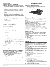
...aids on the mounting À spine of bottom contours and depth soundings and simplifies map presentation for Garmin devices: • Software updates • Map updates • Data uploads to Garmin Connect • Product registration Device Care NOTICE Do not store the device where prolonged... locks in different colors so the marine POIs are off the device and disconnect the device from your computer, install Garmin Express™ (www.garmin.com /express). This provides easy access to use while fishing. By default, the device is connected. Avoid chemical ...
...aids on the mounting À spine of bottom contours and depth soundings and simplifies map presentation for Garmin devices: • Software updates • Map updates • Data uploads to Garmin Connect • Product registration Device Care NOTICE Do not store the device where prolonged... locks in different colors so the marine POIs are off the device and disconnect the device from your computer, install Garmin Express™ (www.garmin.com /express). This provides easy access to use while fishing. By default, the device is connected. Avoid chemical ...
Owners Manual
Page 22
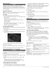
...Device Information Your device and memory card (optional) appear as removable drives in 1 meter of water for additional storage or pre-loaded maps. 1 Turn the D-ring counter-clockwise, and pull up to completely remove the files. Prolonged submersion can withstand immersion in My ... (Downloading Geocaches Using a Computer, page 7). • JPEG photo files. • GPI custom POI files from your device is not necessary to Garmin Connect. Water Immersion NOTICE The device is not compatible with Windows 95, 98, Me, Windows NT®, and Mac OS 10.3 and earlier. Installing...
...Device Information Your device and memory card (optional) appear as removable drives in 1 meter of water for additional storage or pre-loaded maps. 1 Turn the D-ring counter-clockwise, and pull up to completely remove the files. Prolonged submersion can withstand immersion in My ... (Downloading Geocaches Using a Computer, page 7). • JPEG photo files. • GPI custom POI files from your device is not necessary to Garmin Connect. Water Immersion NOTICE The device is not compatible with Windows 95, 98, Me, Windows NT®, and Mac OS 10.3 and earlier. Installing...
Owners Manual
Page 26
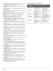
... Dest.: The remaining distance to the next waypoint on your user profile and maximum heart rate (220 minus your current location above ground level (if maps contain sufficient elevation information). For example, if you will reach the next waypoint on the compass. Maximum: The highest elevation reached since the last reset...
... Dest.: The remaining distance to the next waypoint on your user profile and maximum heart rate (220 minus your current location above ground level (if maps contain sufficient elevation information). For example, if you will reach the next waypoint on the compass. Maximum: The highest elevation reached since the last reset...
Owners Manual
Page 27
... temperature. Waypoint at which you are closing on the route. You must be navigating for this data to appear. You must be navigating for all maps and in which you must be connected to appear. You must move to a predetermined altitude. Speed Limit: The reported speed limit for the current activity...
... temperature. Waypoint at which you are closing on the route. You must be navigating for this data to appear. You must be navigating for all maps and in which you must be connected to appear. You must move to a predetermined altitude. Speed Limit: The reported speed limit for the current activity...
Owners Manual
Page 28
...elevation 10 plot 8, 10, 11 24 emergency alert 4 emergency alerts 4 F FCC, licensing 21 files, transferring 7, 12, 18 fitness 16 G Garmin Connect 5 storing data 13 Garmin Express, updating software 17 geocaches 6, 7, 18 downloading 7 navigating to 6 settings 16 geocachesdownloading 6 GLONASS 15 GPS 2, 12, 15 signal 12 H... number 21 K keys 2, 14 L lifetime athlete 16 locations editing 10 saving 10 locking, screen 2 M main menu, customizing 14 map settings 15 maps 9, 15 data fields 14 navigating 9 optional 9 settings 15 updating 17 marine alarms setup 17 settings 17 memory card 18 microphone 5, ...
...elevation 10 plot 8, 10, 11 24 emergency alert 4 emergency alerts 4 F FCC, licensing 21 files, transferring 7, 12, 18 fitness 16 G Garmin Connect 5 storing data 13 Garmin Express, updating software 17 geocaches 6, 7, 18 downloading 7 navigating to 6 settings 16 geocachesdownloading 6 GLONASS 15 GPS 2, 12, 15 signal 12 H... number 21 K keys 2, 14 L lifetime athlete 16 locations editing 10 saving 10 locking, screen 2 M main menu, customizing 14 map settings 15 maps 9, 15 data fields 14 navigating 9 optional 9 settings 15 updating 17 marine alarms setup 17 settings 17 memory card 18 microphone 5, ...


