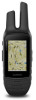
Owners Manual
Page 3
... to a Geocache List 7 Downloading Geocaches Using a Computer 7 chirp 7 Enabling chirp Searching 7 Finding a Geocache with a chirp 7 Removing Live Geocache Data from the Device 7 Removing Your Device Registration From Geocaching.com ..... 7 Activities 7 Recording an Activity 8 Creating a New Activity 8 Editing an Activity Name 8 Editing an Activity Icon 8 Deleting an Activity 8 Customizing Your Activity Log 8 Pausing an Activity 8 Saving the Current Activity 8 Clearing the Current Activity 8 Deleting an Activity History 8 Viewing Activity Information 8 Viewing the Elevation...
... to a Geocache List 7 Downloading Geocaches Using a Computer 7 chirp 7 Enabling chirp Searching 7 Finding a Geocache with a chirp 7 Removing Live Geocache Data from the Device 7 Removing Your Device Registration From Geocaching.com ..... 7 Activities 7 Recording an Activity 8 Creating a New Activity 8 Editing an Activity Name 8 Editing an Activity Icon 8 Deleting an Activity 8 Customizing Your Activity Log 8 Pausing an Activity 8 Saving the Current Activity 8 Clearing the Current Activity 8 Deleting an Activity History 8 Viewing Activity Information 8 Viewing the Elevation...
Owners Manual
Page 4
... Resetting Data and Settings 17 Restoring Default Values for Specific Settings 17 Restoring Default Values for Specific Page Settings 17 Restoring All Default Settings 17 Device Information 17 Attaching the Carabiner Clip 17 Headsets and Microphones 17 Product Updates 17 Device Care 17 Cleaning the Device 17 Cleaning the Touchscreen 17 Water Immersion 18 Data Management 18 File Types 18 Installing a Memory Card 18 Connecting the Device to Your Computer 18 Transferring Files to Your Device 18 Deleting Files 18 Disconnecting the USB Cable...
... Resetting Data and Settings 17 Restoring Default Values for Specific Settings 17 Restoring Default Values for Specific Page Settings 17 Restoring All Default Settings 17 Device Information 17 Attaching the Carabiner Clip 17 Headsets and Microphones 17 Product Updates 17 Device Care 17 Cleaning the Device 17 Cleaning the Touchscreen 17 Water Immersion 18 Data Management 18 File Types 18 Installing a Memory Card 18 Connecting the Device to Your Computer 18 Transferring Files to Your Device 18 Deleting Files 18 Disconnecting the USB Cable...
Owners Manual
Page 5
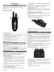
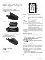
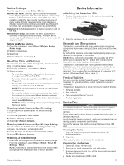
... Ä microSD® card slot (under battery door) Å Battery Information WARNING The temperature rating for the device may need to extend the life of the batteries. • Reduce the backlight brightness (Adjusting the Backlight Brightness, page 14). • Reduce the backlight timeout (Display Settings, page 15). • Use battery save mode (Turning On Battery Save Mode, page 1). • Decrease the map drawing speed (Configuring the Maps, page 15). • Turn off when the backlight...
... Ä microSD® card slot (under battery door) Å Battery Information WARNING The temperature rating for the device may need to extend the life of the batteries. • Reduce the backlight brightness (Adjusting the Backlight Brightness, page 14). • Reduce the backlight timeout (Display Settings, page 15). • Use battery save mode (Turning On Battery Save Mode, page 1). • Decrease the map drawing speed (Configuring the Maps, page 15). • Turn off when the backlight...
Owners Manual
Page 6
... drawer contains all of the applications used your navigation device, the GPS receiver must collect satellite data and establish the current location. Device Operation You can customize the function of this device using a combination of hardware key and touchscreen actions. Main menu Ä Select the radio dashboard at the bottom, connect the two parts of the battery pack together and press until the top locks into place. 5 Align the metal...
... drawer contains all of the applications used your navigation device, the GPS receiver must collect satellite data and establish the current location. Device Operation You can customize the function of this device using a combination of hardware key and touchscreen actions. Main menu Ä Select the radio dashboard at the bottom, connect the two parts of the battery pack together and press until the top locks into place. 5 Align the metal...
Owners Manual
Page 7
... Mode This device can adjust the sensitivity level of the radio. When communicating with other Garmin Rino devices, additional features are using the same squelch tone mode (Changing the Squelch Tone Mode, page 3). A list of squelch tone modes, CTCSS and DCS. NOTE: GMRS frequencies are using the same squelch tone mode. 1 From the radio app, select > Radio Setup > Squelch Tone Mode. After you to mute or restore the radio volume (optional). Rino devices...
... Mode This device can adjust the sensitivity level of the radio. When communicating with other Garmin Rino devices, additional features are using the same squelch tone mode (Changing the Squelch Tone Mode, page 3). A list of squelch tone modes, CTCSS and DCS. NOTE: GMRS frequencies are using the same squelch tone mode. 1 From the radio app, select > Radio Setup > Squelch Tone Mode. After you to mute or restore the radio volume (optional). Rino devices...
Owners Manual
Page 8
... to include only specific channels and squelch codes. The location of the contact is updated on the Map 1 From the main menu, select Contacts. From the new contact page, select Save. Due to find a channel with light activity for other radio users in your contacts list. Users can scan the channels for any activity, including static and weak voice signals. This is helpful if a signal is saved in your position...
... to include only specific channels and squelch codes. The location of the contact is updated on the Map 1 From the main menu, select Contacts. From the new contact page, select Save. Due to find a channel with light activity for other radio users in your contacts list. Users can scan the channels for any activity, including static and weak voice signals. This is helpful if a signal is saved in your position...
Owners Manual
Page 9
... device. 3 Select a Connect IQ feature. 4 Follow the on -screen instructions to a compatible smartphone using only 1/2 W power. Activity uploads to Garmin Connect: Automatically sends your activity to your device with your smartphone. 1 From the settings in Canada (Repeater Channels, page 4). Data Fields: Allow you to a smartphone, the device provides current weather conditions, forecasts, and weather-radar information from Garmin and other Rino users. Downloading Connect IQ Features Before you transmit to update your connections and other Rino users. Send Location: Enables...
... device. 3 Select a Connect IQ feature. 4 Follow the on -screen instructions to a compatible smartphone using only 1/2 W power. Activity uploads to Garmin Connect: Automatically sends your activity to your device with your smartphone. 1 From the settings in Canada (Repeater Channels, page 4). Data Fields: Allow you to a smartphone, the device provides current weather conditions, forecasts, and weather-radar information from Garmin and other Rino users. Downloading Connect IQ Features Before you transmit to update your connections and other Rino users. Send Location: Enables...
Owners Manual
Page 11
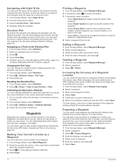
... are using your results. 1 While navigating to a geocache, from the device and no longer appears in a geocache. If you change the name (Editing a Custom Geocache Filter, page 7). • To turn chirp™ searching on . Logging the Attempt After you start an activity, the device displays and records sensor data. Removing Live Geocache Data from the Device You can log your Garmin Connect account (Connect IQ Features, page 5). From the app drawer, select Setup...
... are using your results. 1 While navigating to a geocache, from the device and no longer appears in a geocache. If you change the name (Editing a Custom Geocache Filter, page 7). • To turn chirp™ searching on . Logging the Attempt After you start an activity, the device displays and records sensor data. Removing Live Geocache Data from the Device You can log your Garmin Connect account (Connect IQ Features, page 5). From the app drawer, select Setup...
Owners Manual
Page 13
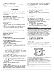
... -screen instructions. NOTE: Not all map data provides postal code searching. 4 Select the city. 5 Enter the house number. 6 Enter the street. Calibrating the Compass NOTICE Calibrate the electronic compass outdoors. Indicates the location of the Á desired course line in the device. You can use , and archive tracks using the track manager. Navigating to a Destination 1 If necessary, select the activity to a Destination, page 9). 2 From the app drawer, select Map. The map opens and your route...
... -screen instructions. NOTE: Not all map data provides postal code searching. 4 Select the city. 5 Enter the house number. 6 Enter the street. Calibrating the Compass NOTICE Calibrate the electronic compass outdoors. Indicates the location of the Á desired course line in the device. You can use , and archive tracks using the track manager. Navigating to a Destination 1 If necessary, select the activity to a Destination, page 9). 2 From the app drawer, select Map. The map opens and your route...
Owners Manual
Page 14
.... 6 Enter the distance, and select . 7 Select Save. 10 Waypoints Resetting the Elevation Plot 1 From the app drawer, select Altimeter. 2 Select > Reset > Clear Current Activity > Clear. You can mark your current location to the observed location, then navigate to view the list of a waypoint location by transferring the file to the GPX folder (Transferring Files to a location where the elevation or barometric pressure is known. 2 From the app drawer, select Altimeter. 3 Select > Altimeter Setup > Calibrate Altimeter. 4 Follow the on -screen instructions. 6 When...
.... 6 Enter the distance, and select . 7 Select Save. 10 Waypoints Resetting the Elevation Plot 1 From the app drawer, select Altimeter. 2 Select > Reset > Clear Current Activity > Clear. You can mark your current location to the observed location, then navigate to view the list of a waypoint location by transferring the file to the GPX folder (Transferring Files to a location where the elevation or barometric pressure is known. 2 From the app drawer, select Altimeter. 3 Select > Altimeter Setup > Calibrate Altimeter. 4 Follow the on -screen instructions. 6 When...
Owners Manual
Page 15
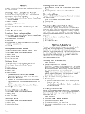
... or memory card drive or volume. 4 Select an option: • Select an item from a connected device and drag it distinct. 1 From the app drawer, select Route Planner. 2 Select a route. 3 Select Change Name. 4 Enter the new name. See your computer. Creating a Route Using the Map 1 From the app drawer, select Route Planner > Create Route > Select First Point > Use Map. 2 Move the map to select a point. 3 Select Use. 4 Move the map, and select additional points on -road routing, the elevation plot displays the elevations along the roads included in the route. 4 Select Use. 5 Select Select Next...
... or memory card drive or volume. 4 Select an option: • Select an item from a connected device and drag it distinct. 1 From the app drawer, select Route Planner. 2 Select a route. 3 Select Change Name. 4 Enter the new name. See your computer. Creating a Route Using the Map 1 From the app drawer, select Route Planner > Create Route > Select First Point > Use Map. 2 Move the map to select a point. 3 Select Use. 4 Move the map, and select additional points on -road routing, the elevation plot displays the elevations along the roads included in the route. 4 Select Use. 5 Select Select Next...
Owners Manual
Page 16
..., you must download an adventure from Garmin Connect (Using Garmin Connect, page 13), or send an adventure from another compatible device using Bluetooth or ANT+® wireless technology. Camera and Photos NOTE: This feature is saved with your current location, GPS accuracy, satellite locations, and signal strength. Taking a Photo 1 From the app drawer, select Camera. 2 Turn the device horizontally or vertically to change the cover photo for the adventure, select Change, and select a different photo. 7 Select Finish...
..., you must download an adventure from Garmin Connect (Using Garmin Connect, page 13), or send an adventure from another compatible device using Bluetooth or ANT+® wireless technology. Camera and Photos NOTE: This feature is saved with your current location, GPS accuracy, satellite locations, and signal strength. Taking a Photo 1 From the app drawer, select Camera. 2 Turn the device horizontally or vertically to change the cover photo for the adventure, select Change, and select a different photo. 7 Select Finish...
Owners Manual
Page 17
.... Using Garmin Connect 1 Connect the device to keep track of the calculators available on the Internet. If you do not appear on -screen instructions. Fitness 13 When the device memory is stopped or paused. Deleting an Activity from other accessories. Pairing is activated. NOTE: Stay 10 m (30 ft.) away from other ANT+ sensors while pairing. 2 From the app drawer, select Setup > ANT Sensor. 3 Select your computer using the USB cable. 2 Go...
.... Using Garmin Connect 1 Connect the device to keep track of the calculators available on the Internet. If you do not appear on -screen instructions. Fitness 13 When the device memory is stopped or paused. Deleting an Activity from other accessories. Pairing is activated. NOTE: Stay 10 m (30 ft.) away from other ANT+ sensors while pairing. 2 From the app drawer, select Setup > ANT Sensor. 3 Select your computer using the USB cable. 2 Go...
Owners Manual
Page 18
... adjust the backlight brightness to a specific device setting. Creating a Shortcut 1 From the app drawer, select Setup > Shortcuts > Create Shortcut. 2 Select Name, and enter a name. 3 Select Icon, and select an icon. 4 Select an option: • To add a shortcut to maximize the battery life. You can customize the data fields and dashboards of the screen. 2 Select or . Changing Items on the main menu, or switch to a different page of the main menu, select and . • To change your location or other device...
... adjust the backlight brightness to a specific device setting. Creating a Shortcut 1 From the app drawer, select Setup > Shortcuts > Create Shortcut. 2 Select Name, and enter a name. 3 Select Icon, and select an icon. 4 Select an option: • To add a shortcut to maximize the battery life. You can customize the data fields and dashboards of the screen. 2 Select or . Changing Items on the main menu, or switch to a different page of the main menu, select and . • To change your location or other device...
Owners Manual
Page 19
... display on the device. Mode: Sets the home screen to adjust the satellite system settings (Satellite Settings, page 15). Battery Type: Sets the battery type for map items. System Settings From the app drawer, select Setup > System. WAAS/EGNOS: Sets the satellite system to Garmin Spanner, Garmin Serial, NMEA In/Out, Text Out, RTCM, or MTP. Using GPS and GLONASS can reduce battery life more information about your route or your location. Setting the Device Tones You can enable or disable the maps currently loaded on the map...
... display on the device. Mode: Sets the home screen to adjust the satellite system settings (Satellite Settings, page 15). Battery Type: Sets the battery type for map items. System Settings From the app drawer, select Setup > System. WAAS/EGNOS: Sets the satellite system to Garmin Spanner, Garmin Serial, NMEA In/Out, Text Out, RTCM, or MTP. Using GPS and GLONASS can reduce battery life more information about your route or your location. Setting the Device Tones You can enable or disable the maps currently loaded on the map...
Owners Manual
Page 20
... coordinate system the device is started. Time Settings From the app drawer, select Setup > Time. User: Sets the user profile information (Setting Your Fitness User Profile, page 16). Display: Sets the type of an activity. 1 From the app drawer, select Setup > Fitness > Auto Lap. 2 Enter a value, and select . 16 Customizing the Device North Reference: Sets the north reference used on the map, onto the nearest road. Altimeter Settings From the app drawer, select Setup > Altimeter. Fitness Settings From the app drawer, select Setup > Fitness. Lock On Road: Locks...
... coordinate system the device is started. Time Settings From the app drawer, select Setup > Time. User: Sets the user profile information (Setting Your Fitness User Profile, page 16). Display: Sets the type of an activity. 1 From the app drawer, select Setup > Fitness > Auto Lap. 2 Enter a value, and select . 16 Customizing the Device North Reference: Sets the north reference used on the map, onto the nearest road. Altimeter Settings From the app drawer, select Setup > Altimeter. Fitness Settings From the app drawer, select Setup > Fitness. Lock On Road: Locks...
Owners Manual
Page 21
... damage to detect the headset. Device Information 17 NOTE: The device continues to record new data for the current activity. • To reset the settings for the device to the USB port. On your computer, install Garmin Express™ (www.garmin.com /express). Nautical displays various map features in place. Marine Chart Mode: Sets the type of connected VOX devices (Advanced Radio Setup, page 5). Restoring Default Values for Specific Page Settings You can damage plastic components and...
... damage to detect the headset. Device Information 17 NOTE: The device continues to record new data for the current activity. • To reset the settings for the device to the USB port. On your computer, install Garmin Express™ (www.garmin.com /express). Nautical displays various map features in place. Marine Chart Mode: Sets the type of connected VOX devices (Advanced Radio Setup, page 5). Restoring Default Values for Specific Page Settings You can damage plastic components and...
Owners Manual
Page 22
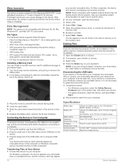
... delete it . 6 Replace the battery pack, and turn the D-ring clockwise. NOTE: If you are using or charging. Your device and memory card (optional) appear as mounted volumes on the memory card. as mounted volumes. Deleting Files NOTICE If you must safely disconnect your device from your computer to your keyboard. If your device is connected to your Windows computer as a portable device, it is connected to your computer as a removable drive or a portable device...
... delete it . 6 Replace the battery pack, and turn the D-ring clockwise. NOTE: If you are using or charging. Your device and memory card (optional) appear as mounted volumes on the memory card. as mounted volumes. Deleting Files NOTICE If you must safely disconnect your device from your computer to your keyboard. If your device is connected to your Windows computer as a portable device, it is connected to your computer as a removable drive or a portable device...
Owners Manual
Page 25
.... 2 Turn off (Simulating a Location, page 12). • Take your phone within 10 m (33 ft.) of accurate temperature data. No license is required to operate on the GMRS frequencies is associated with your computer. 4 Continue holding for 30 seconds or until the device goes into mass storage mode automatically, you connect the device to your device to factory default values Select Setup > Reset > Reset All Settings. My device is not acquiring satellite signals •...
.... 2 Turn off (Simulating a Location, page 12). • Take your phone within 10 m (33 ft.) of accurate temperature data. No license is required to operate on the GMRS frequencies is associated with your computer. 4 Continue holding for 30 seconds or until the device goes into mass storage mode automatically, you connect the device to your device to factory default values Select Setup > Reset > Reset All Settings. My device is not acquiring satellite signals •...
Owners Manual
Page 28
... files, transferring 7, 12, 18 fitness 16 G Garmin Connect 5 storing data 13 Garmin Express, updating software 17 geocaches 6, 7, 18 downloading 7 navigating to 6 settings 16 geocachesdownloading 6 GLONASS 15 GPS 2, 12, 15 signal 12 H heading setting 16 headphones 5, 17 heart rate, zones 13, 23 history 13 sending to -peer positioning 4 scan 4 settings 5 volume 3 registering the device 6 resetting the device 17, 21 restoring, settings 17 routes 11 creating 11 deleting 11 editing 11 settings 15 viewing on the map 11 S satellite signals 12 acquiring 2 locations...
... files, transferring 7, 12, 18 fitness 16 G Garmin Connect 5 storing data 13 Garmin Express, updating software 17 geocaches 6, 7, 18 downloading 7 navigating to 6 settings 16 geocachesdownloading 6 GLONASS 15 GPS 2, 12, 15 signal 12 H heading setting 16 headphones 5, 17 heart rate, zones 13, 23 history 13 sending to -peer positioning 4 scan 4 settings 5 volume 3 registering the device 6 resetting the device 17, 21 restoring, settings 17 routes 11 creating 11 deleting 11 editing 11 settings 15 viewing on the map 11 S satellite signals 12 acquiring 2 locations...


