Owners Manual
Page 3
... to a Geocache List 7 Downloading Geocaches Using a Computer 7 chirp 7 Enabling chirp Searching 7 Finding a Geocache with a chirp 7 Removing Live Geocache Data from the Device 7 Removing Your Device Registration From Geocaching.com ..... 7 Activities 7 Recording an Activity 8 Creating a New Activity 8 Editing an Activity Name 8 Editing an Activity Icon 8 Deleting an Activity 8 Customizing Your Activity Log 8 Pausing an Activity 8 Saving the Current Activity 8 Clearing the Current Activity 8 Deleting an Activity History 8 Viewing Activity Information 8 Viewing the Elevation...
... to a Geocache List 7 Downloading Geocaches Using a Computer 7 chirp 7 Enabling chirp Searching 7 Finding a Geocache with a chirp 7 Removing Live Geocache Data from the Device 7 Removing Your Device Registration From Geocaching.com ..... 7 Activities 7 Recording an Activity 8 Creating a New Activity 8 Editing an Activity Name 8 Editing an Activity Icon 8 Deleting an Activity 8 Customizing Your Activity Log 8 Pausing an Activity 8 Saving the Current Activity 8 Clearing the Current Activity 8 Deleting an Activity History 8 Viewing Activity Information 8 Viewing the Elevation...
Owners Manual
Page 4
... Resetting Data and Settings 17 Restoring Default Values for Specific Settings 17 Restoring Default Values for Specific Page Settings 17 Restoring All Default Settings 17 Device Information 17 Attaching the Carabiner Clip 17 Headsets and Microphones 17 Product Updates 17 Device Care 17 Cleaning the Device 17 Cleaning the Touchscreen 17 Water Immersion 18 Data Management 18 File Types 18 Installing a Memory Card 18 Connecting the Device to Your Computer 18 Transferring Files to Your Device 18 Deleting Files 18 Disconnecting the USB Cable...
... Resetting Data and Settings 17 Restoring Default Values for Specific Settings 17 Restoring Default Values for Specific Page Settings 17 Restoring All Default Settings 17 Device Information 17 Attaching the Carabiner Clip 17 Headsets and Microphones 17 Product Updates 17 Device Care 17 Cleaning the Device 17 Cleaning the Touchscreen 17 Water Immersion 18 Data Management 18 File Types 18 Installing a Memory Card 18 Connecting the Device to Your Computer 18 Transferring Files to Your Device 18 Deleting Files 18 Disconnecting the USB Cable...
Owners Manual
Page 5
... device may need to charge a battery that was not provided by Garmin®. Long-Term Storage When you do several months, remove the batteries. NOTICE Alkaline batteries lose a significant amount of the batteries. • Reduce the backlight brightness (Adjusting the Backlight Brightness, page 14). • Reduce the backlight timeout (Display Settings, page 15). • Use battery save mode, the screen shuts off GLONASS (GPS and GLONASS, page 15). Turning On Battery Save Mode You can charge the battery using...
... device may need to charge a battery that was not provided by Garmin®. Long-Term Storage When you do several months, remove the batteries. NOTICE Alkaline batteries lose a significant amount of the batteries. • Reduce the backlight brightness (Adjusting the Backlight Brightness, page 14). • Reduce the backlight timeout (Display Settings, page 15). • Use battery save mode, the screen shuts off GLONASS (GPS and GLONASS, page 15). Turning On Battery Save Mode You can charge the battery using...
Owners Manual
Page 6
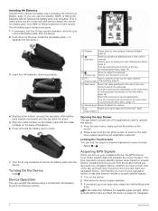
... to turn on your navigation device, the GPS receiver must collect satellite data and establish the current location. Turning On the Device Hold . You can customize the function of this key (Customizing the Keys, page 14). Locking the Touchscreen You can operate this device. 1 From the main menu, swipe up from the bottom of the screen. 2 Swipe down from the location where you last used your navigation device. The time required to acquire satellite signals...
... to turn on your navigation device, the GPS receiver must collect satellite data and establish the current location. Turning On the Device Hold . You can customize the function of this key (Customizing the Keys, page 14). Locking the Touchscreen You can operate this device. 1 From the main menu, swipe up from the bottom of the screen. 2 Swipe down from the location where you last used your navigation device. The time required to acquire satellite signals...
Owners Manual
Page 7
... receiving your position information, and you no longer hear the unwanted background noise. Radio In the United States and Canada, this device uses Family Radio Service (FRS) and General Mobile Radio Service (GMRS) for two-way communication with other Garmin Rino devices, additional features are available. The volume screen appears. 2 Select under the Squelch bar. Calls on the channel. 3 Select . When communicating with other radio settings in the United States...
... receiving your position information, and you no longer hear the unwanted background noise. Radio In the United States and Canada, this device uses Family Radio Service (FRS) and General Mobile Radio Service (GMRS) for two-way communication with other Garmin Rino devices, additional features are available. The volume screen appears. 2 Select under the Squelch bar. Calls on the channel. 3 Select . When communicating with other radio settings in the United States...
Owners Manual
Page 8
... be on GMRS repeater channels. Navigating to FCC restrictions. Configuring the Scan List By default, all users on the Map 1 From the main menu, select Contacts. Saving a New Contact The first time the device receives a peer-to FCC regulations, you receive an emergency alert, select Help. 4 Radio Viewing Contacts on your current channel and code, not just to -peer positioning is sent to other Rino users using peer-to a countdown timer...
... be on GMRS repeater channels. Navigating to FCC restrictions. Configuring the Scan List By default, all users on the Map 1 From the main menu, select Contacts. Saving a New Contact The first time the device receives a peer-to FCC regulations, you receive an emergency alert, select Help. 4 Radio Viewing Contacts on your current channel and code, not just to -peer positioning is sent to other Rino users using peer-to a countdown timer...
Owners Manual
Page 9
... on-screen instructions. Squelch Tone Mode: Sets the squelch mode (Changing the Squelch Tone Mode, page 3). Connect IQ Features You can add Connect IQ data fields to monitor for your Rino 750/755t device when you to support transmissions using the Garmin Connect Mobile app. You cannot make or receive transmissions when the radio functionality is recommended for compatibility information. Send Location: Enables sending position information when you to download an extended prediction orbit file to quickly locate GPS satellites and...
... on-screen instructions. Squelch Tone Mode: Sets the squelch mode (Changing the Squelch Tone Mode, page 3). Connect IQ Features You can add Connect IQ data fields to monitor for your Rino 750/755t device when you to support transmissions using the Garmin Connect Mobile app. You cannot make or receive transmissions when the radio functionality is recommended for compatibility information. Send Location: Enables sending position information when you to download an extended prediction orbit file to quickly locate GPS satellites and...
Owners Manual
Page 11
... geocache list. 1 From the geocache list, select . 2 Select a filter. Filtering the Geocache List You can remove live data, or pocket queries you switch the device to this activity. Enabling chirp Searching 1 From the app drawer, select Setup > Geocaching. 2 Select chirp Searching > On. Activities Your device can load geocaches manually onto your computer using a computer (Transferring Files to Your Device, page 18). You can customize the settings for each preloaded activity, and you can create and save activities and...
... geocache list. 1 From the geocache list, select . 2 Select a filter. Filtering the Geocache List You can remove live data, or pocket queries you switch the device to this activity. Enabling chirp Searching 1 From the app drawer, select Setup > Geocaching. 2 Select chirp Searching > On. Activities Your device can load geocaches manually onto your computer using a computer (Transferring Files to Your Device, page 18). You can customize the settings for each preloaded activity, and you can create and save activities and...
Owners Manual
Page 13
... can also navigate to a Destination, page 9). 2 From the app drawer, select Compass. 3 Turn until points toward the top of your destination. NOTE: Not all map data provides postal code searching. 4 Select the city. 5 Enter the house number. 6 Enter the street. Course Pointer The course pointer is indicated by default. The map opens and your route is aligned with the Compass When navigating to a destination, points to your location on the device or...
... can also navigate to a Destination, page 9). 2 From the app drawer, select Compass. 3 Turn until points toward the top of your destination. NOTE: Not all map data provides postal code searching. 4 Select the city. 5 Enter the house number. 6 Enter the street. Course Pointer The course pointer is indicated by default. The map opens and your route is aligned with the Compass When navigating to a destination, points to your location on the device or...
Owners Manual
Page 14
... location data. Navigating to a location you observe on -screen instructions. For best results, collect four to the waypoint location. 4 Select Start. 5 Follow the on the plot. 3 Select . 4 Select View Map. 5 Navigate using the compass. Changing the Plot Type You can mark your current location to the observed location, then navigate to the new location after crossing the river or stream at an object in the distance with the compass direction locked in the device. Marking Your Current Location...
... location data. Navigating to a location you observe on -screen instructions. For best results, collect four to the waypoint location. 4 Select Start. 5 Follow the on the plot. 3 Select . 4 Select View Map. 5 Navigate using the compass. Changing the Plot Type You can mark your current location to the observed location, then navigate to the new location after crossing the river or stream at an object in the distance with the compass direction locked in the device. Marking Your Current Location...
Owners Manual
Page 15
... can use BaseCamp™ to navigate the route in the route. 4 Select Use. 5 Select Select Next Point to add additional points to the route. 6 Select to save the route. You can add, remove, or rearrange points on a route. 1 From the app drawer, select Route Planner. 2 Select a route. 3 Select Edit Route. 4 Select a point. 5 Select an option: • To view the point on your final destination. On Mac® computers, the device and memory card appear as an adventure. Creating a Route Using Route Planner A route can switch the start and end points of your route to create and...
... can use BaseCamp™ to navigate the route in the route. 4 Select Use. 5 Select Select Next Point to add additional points to the route. 6 Select to save the route. You can add, remove, or rearrange points on a route. 1 From the app drawer, select Route Planner. 2 Select a route. 3 Select Edit Route. 4 Select a point. 5 Select an option: • To view the point on your final destination. On Mac® computers, the device and memory card appear as an adventure. Creating a Route Using Route Planner A route can switch the start and end points of your route to create and...
Owners Manual
Page 16
... compatible device must download an adventure from Garmin Connect (Using Garmin Connect, page 13), or send an adventure from another compatible device using Bluetooth or ANT+® wireless technology. When you enter an area with your location. 1 From the app drawer, select Satellite. 2 Select > Use With GPS Off. The alarm sounds at the alarm time, the device turns on your device to view your current location, GPS accuracy, satellite locations, and signal strength. Changing the Satellite View 1 From the app drawer, select Satellite. 2 Select . 3 Select an...
... compatible device must download an adventure from Garmin Connect (Using Garmin Connect, page 13), or send an adventure from another compatible device using Bluetooth or ANT+® wireless technology. When you enter an area with your location. 1 From the app drawer, select Satellite. 2 Select > Use With GPS Off. The alarm sounds at the alarm time, the device turns on your device to view your current location, GPS accuracy, satellite locations, and signal strength. Changing the Satellite View 1 From the app drawer, select Satellite. 2 Select . 3 Select an...
Owners Manual
Page 17
... of all device models. Using Garmin Connect 1 Connect the device to your computer using the USB cable. 2 Go to the instructions included with your device, the sensor status changes from 1 to 5 according to turn on the device. These accessories use ANT+ wireless technology to send data to your device. When the sensor is a set up . • To take a photo, select . When your phone receives messages, it is activated. A heart rate zone is paired with...
... of all device models. Using Garmin Connect 1 Connect the device to your computer using the USB cable. 2 Go to the instructions included with your device, the sensor status changes from 1 to 5 according to turn on the device. These accessories use ANT+ wireless technology to send data to your device. When the sensor is a set up . • To take a photo, select . When your phone receives messages, it is activated. A heart rate zone is paired with...
Owners Manual
Page 18
... be helpful to quickly change the order of the previous zone. Customizing Dashboards 1 Select a page. 14 Customizing the Device For a longer battery life, you must enable them (Enabling the Map Data Fields, page 14). Customizing the Dashboard on the Main Menu By default, radio information appears in the dashboard on the minimum heart rate of items in the app drawer. 1 From the app drawer, select Setup > Main Menu > > Setup Drawer. 2 Select...
... be helpful to quickly change the order of the previous zone. Customizing Dashboards 1 Select a page. 14 Customizing the Device For a longer battery life, you must enable them (Enabling the Map Data Fields, page 14). Customizing the Dashboard on the Main Menu By default, radio information appears in the dashboard on the minimum heart rate of items in the app drawer. 1 From the app drawer, select Setup > Main Menu > > Setup Drawer. 2 Select...
Owners Manual
Page 19
...: Sets the power key or user key as a shortcut to adjust the satellite system settings (Satellite Settings, page 15). Mode: Sets the home screen to Classic by turning off . NOTE: This device is set the satellite system to www.garmin.com/aboutGPS/waas.html. Appearance Settings From the app drawer, select Setup > Appearance. Night Color: Sets the color for transportation while routing. Activity: Sets an activity used to change the language of user-entered data or map data. Each dashboard shows different information about...
...: Sets the power key or user key as a shortcut to adjust the satellite system settings (Satellite Settings, page 15). Mode: Sets the home screen to Classic by turning off . NOTE: This device is set the satellite system to www.garmin.com/aboutGPS/waas.html. Appearance Settings From the app drawer, select Setup > Appearance. Night Color: Sets the color for transportation while routing. Activity: Sets an activity used to change the language of user-entered data or map data. Each dashboard shows different information about...
Owners Manual
Page 20
..., select Setup > Position Format. Time Zone: Sets the time zone for fitness activities. Program chirp: Programs the chirp accessory. ANT+ Sensor Settings For more . Setting Your Fitness User Profile The device uses information that points in a 12-hour or 24- This is available only for distance and speed, elevation, depth, temperature, pressure, and vertical speed. 1 From the app drawer, select Setup > Units. 2 Select a measurement type. 3 Select a unit of measure. Compass: Automatically switches from an electronic compass to Garmin Connect...
..., select Setup > Position Format. Time Zone: Sets the time zone for fitness activities. Program chirp: Programs the chirp accessory. ANT+ Sensor Settings For more . Setting Your Fitness User Profile The device uses information that points in a 12-hour or 24- This is available only for distance and speed, elevation, depth, temperature, pressure, and vertical speed. 1 From the app drawer, select Setup > Units. 2 Select a measurement type. 3 Select a unit of measure. Compass: Automatically switches from an electronic compass to Garmin Connect...
Owners Manual
Page 21
...you started your current activity type to the factory default values, select Reset Activity Settings. • To restore all device settings to a trip, such as distance and averages, select Reset Trip Data. • To delete all settings back to operate the touchscreen, or damage may result. Resetting Data and Settings You can reset trip data, delete all default settings on the map. NOTE: The device continues to record new data for the current activity. • To reset the settings for optimal use while fishing. Restoring Default Values for Specific Page Settings You can adjust...
...you started your current activity type to the factory default values, select Reset Activity Settings. • To restore all device settings to a trip, such as distance and averages, select Reset Trip Data. • To delete all settings back to operate the touchscreen, or damage may result. Resetting Data and Settings You can reset trip data, delete all default settings on the map. NOTE: The device continues to record new data for the current activity. • To reset the settings for optimal use while fishing. Restoring Default Values for Specific Page Settings You can adjust...
Owners Manual
Page 22
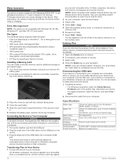
... Mac computers. Installing a Memory Card You can cause damage to www.garmin.com /trip_planning. • GPX route, track, and waypoint files. • GPX geocache files (Downloading Geocaches Using a Computer, page 7). • JPEG photo files. • GPI custom POI files from BaseCamp or HomePort™. The file appears in the list of the USB cable into the USB port on your computer. NOTE: If you are using or charging. AA batteries: up . File Types The handheld device supports these file types...
... Mac computers. Installing a Memory Card You can cause damage to www.garmin.com /trip_planning. • GPX route, track, and waypoint files. • GPX geocache files (Downloading Geocaches Using a Computer, page 7). • JPEG photo files. • GPI custom POI files from BaseCamp or HomePort™. The file appears in the list of the USB cable into the USB port on your computer. NOTE: If you are using or charging. AA batteries: up . File Types The handheld device supports these file types...
Owners Manual
Page 25
... CFR Part 95. Operation on your phone and bring your phone within 10 m (33 ft.) of a foreign government, is subject to display data. 24 hr Max. A filing fee is turned off the device. 3 Hold while you connect the device to apply for more help. For use in the United States. My device is not acquiring satellite signals • Verify the GPS simulator is associated with this application. Data Fields Some data fields...
... CFR Part 95. Operation on your phone and bring your phone within 10 m (33 ft.) of a foreign government, is subject to display data. 24 hr Max. A filing fee is turned off the device. 3 Hold while you connect the device to apply for more help. For use in the United States. My device is not acquiring satellite signals • Verify the GPS simulator is associated with this application. Data Fields Some data fields...
Owners Manual
Page 28
... files, transferring 7, 12, 18 fitness 16 G Garmin Connect 5 storing data 13 Garmin Express, updating software 17 geocaches 6, 7, 18 downloading 7 navigating to 6 settings 16 geocachesdownloading 6 GLONASS 15 GPS 2, 12, 15 signal 12 H heading setting 16 headphones 5, 17 heart rate, zones 13, 23 history 13 sending to -peer positioning 4 scan 4 settings 5 volume 3 registering the device 6 resetting the device 17, 21 restoring, settings 17 routes 11 creating 11 deleting 11 editing 11 settings 15 viewing on the map 11 S satellite signals 12 acquiring 2 locations...
... files, transferring 7, 12, 18 fitness 16 G Garmin Connect 5 storing data 13 Garmin Express, updating software 17 geocaches 6, 7, 18 downloading 7 navigating to 6 settings 16 geocachesdownloading 6 GLONASS 15 GPS 2, 12, 15 signal 12 H heading setting 16 headphones 5, 17 heart rate, zones 13, 23 history 13 sending to -peer positioning 4 scan 4 settings 5 volume 3 registering the device 6 resetting the device 17, 21 restoring, settings 17 routes 11 creating 11 deleting 11 editing 11 settings 15 viewing on the map 11 S satellite signals 12 acquiring 2 locations...


