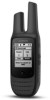
User Guide
Page 2
... in high temperature environments, such as the Global Positioning Service (GPS). FCC Compliance This device complies with correct replacement batteries. An individual 18 years of age or older, who is not an authorized service provider of Garmin; (v) damage to a product that has been modified or altered... OR SUSPEND OTHER LEGAL RIGHTS YOU MAY HAVE UNDER THE LAWS OF YOUR STATE (OR COUNTRY OR PROVINCE). Garmin navigation products are required to obtain a license from the GPS device. • Consult the dealer or an experienced radio/TV technician for any user-serviceable parts. Hearing ...
... in high temperature environments, such as the Global Positioning Service (GPS). FCC Compliance This device complies with correct replacement batteries. An individual 18 years of age or older, who is not an authorized service provider of Garmin; (v) damage to a product that has been modified or altered... OR SUSPEND OTHER LEGAL RIGHTS YOU MAY HAVE UNDER THE LAWS OF YOUR STATE (OR COUNTRY OR PROVINCE). Garmin navigation products are required to obtain a license from the GPS device. • Consult the dealer or an experienced radio/TV technician for any user-serviceable parts. Hearing ...
Owners Manual
Page 3
...a Channel 2 Selecting a Squelch Code 2 Monitoring a Channel for Activity 2 Scanning Channels 3 Repeater Channels 3 Peer-to-Peer Positioning 3 Polling Other Rino Users 3 Editing Your Contact Info 3 Contacts 3 Saving a New Contact 3 Viewing Contacts on the Map 3 Navigating to a Contact 3 Notes ... the Data Fields 8 Adjusting the Backlight Brightness 8 Display Settings 8 Map Settings 8 Advanced Map Settings 8 System Settings 8 About GPS and GLONASS 8 Setting the Device Tones 8 Routing Settings 9 Heading Settings 9 Position Format Settings 9 Changing the Units of Measure ...
...a Channel 2 Selecting a Squelch Code 2 Monitoring a Channel for Activity 2 Scanning Channels 3 Repeater Channels 3 Peer-to-Peer Positioning 3 Polling Other Rino Users 3 Editing Your Contact Info 3 Contacts 3 Saving a New Contact 3 Viewing Contacts on the Map 3 Navigating to a Contact 3 Notes ... the Data Fields 8 Adjusting the Backlight Brightness 8 Display Settings 8 Map Settings 8 Advanced Map Settings 8 System Settings 8 About GPS and GLONASS 8 Setting the Device Tones 8 Routing Settings 9 Heading Settings 9 Position Format Settings 9 Changing the Units of Measure ...

Owners Manual
Page 5
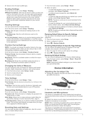
...a computer USB port. 4 If necessary, plug the AC adapter into power saving mode. Press to a computer. Device Operation GMRS antenna GPS antenna Mini-USB port (under weather cap) 2.5 mm headset jack (under weather cap) Charging the Battery NOTICE To prevent corrosion, thoroughly ... adjust the backlight and check battery level. Hold to highlight a menu item, adjust a slider, and control the map cursor. shows the GPS/GLONASS signal strength. Introduction WARNING See the Important Safety and Product Information guide in power saving mode. Use to mark a waypoint (Waypoints, ...
...a computer USB port. 4 If necessary, plug the AC adapter into power saving mode. Press to a computer. Device Operation GMRS antenna GPS antenna Mini-USB port (under weather cap) 2.5 mm headset jack (under weather cap) Charging the Battery NOTICE To prevent corrosion, thoroughly ... adjust the backlight and check battery level. Hold to highlight a menu item, adjust a slider, and control the map cursor. shows the GPS/GLONASS signal strength. Introduction WARNING See the Important Safety and Product Information guide in power saving mode. Use to mark a waypoint (Waypoints, ...

Owners Manual
Page 9
...location, another waypoint, your current location, or a point on the map. • Select Sort to view the list of waypoints based on the other Rino users. 1 From the home screen, select Waypoint Manager. 2 Select a waypoint. 3 Select > Send Location. Creating a Route Using the Map 1 ...the home screen, select Route Planner. 2 Select a route. 3 Select Change Name. 4 Enter the new name. When averaging, the device takes several GPS readings at the same location and uses the average value to provide more suitable location. 1 From the home screen, select Waypoint Manager. 2 Select a waypoint...
...location, another waypoint, your current location, or a point on the map. • Select Sort to view the list of waypoints based on the other Rino users. 1 From the home screen, select Waypoint Manager. 2 Select a waypoint. 3 Select > Send Location. Creating a Route Using the Map 1 ...the home screen, select Route Planner. 2 Select a route. 3 Select Change Name. 4 Enter the new name. When averaging, the device takes several GPS readings at the same location and uses the average value to provide more suitable location. 1 From the home screen, select Waypoint Manager. 2 Select a waypoint...

Owners Manual
Page 10
... path. Opening Track Manager You can log your route to navigate the route in which players hide or search for hidden caches using clues and GPS coordinates. From the home screen, select Track Manager. Information about points along the recorded path, including time, location, and elevation for each point. Logging the...
... path. Opening Track Manager You can log your route to navigate the route in which players hide or search for hidden caches using clues and GPS coordinates. From the home screen, select Track Manager. Information about points along the recorded path, including time, location, and elevation for each point. Logging the...
Owners Manual
Page 11
...last application on the home screen. You may need to add this application to the home screen before you often use the device with GPS off to perform maintenance on waypoints and routes, or to the Home Screen, page 7). 2 Walk around the perimeter of a particular location... by a number. Changing the Satellite View 1 From the home screen, select Satellite. 2 Select > Track Up to view your current location, GPS accuracy, satellite locations, and signal strength. Customizing the Device 7 Saving a Custom Geocache Filter You can create and save custom filters for geocaches based...
...last application on the home screen. You may need to add this application to the home screen before you often use the device with GPS off to perform maintenance on waypoints and routes, or to the Home Screen, page 7). 2 Walk around the perimeter of a particular location... by a number. Changing the Satellite View 1 From the home screen, select Satellite. 2 Select > Track Up to view your current location, GPS accuracy, satellite locations, and signal strength. Customizing the Device 7 Saving a Custom Geocache Filter You can create and save custom filters for geocaches based...
Owners Manual
Page 12
... language files from the device when you change with specific Garmin applications. NOTE: Additional language files are using the device for marine use. About GPS and GLONASS The default satellite system setting is higher than GPS only. 5 Press the Thumb Stick controller. When you change...3 Select a data field category and a data field. Waypoints do not appear when the map zoom level is GPS. WAAS/EGNOS: Sets the satellite system to Mass Storage or Garmin. Using GPS and GLONASS can select them (Enabling the Map Data Fields or Dashboards, page 8). Adding a Profile The device...
... language files from the device when you change with specific Garmin applications. NOTE: Additional language files are using the device for marine use. About GPS and GLONASS The default satellite system setting is higher than GPS only. 5 Press the Thumb Stick controller. When you change...3 Select a data field category and a data field. Waypoints do not appear when the map zoom level is GPS. WAAS/EGNOS: Sets the satellite system to Mass Storage or Garmin. Using GPS and GLONASS can select them (Enabling the Map Data Fields or Dashboards, page 8). Adding a Profile The device...
Owners Manual
Page 13
.... 2 Slide the carabiner clip up until it locks in a 12-hour or 24- This number automatically increases when you to edit the number of your GPS position. By default, the device is set to show time in place. These accessories allow you log a find (Logging the Attempt, page 6). Restoring Default Values...
.... 2 Slide the carabiner clip up until it locks in a 12-hour or 24- This number automatically increases when you to edit the number of your GPS position. By default, the device is set to show time in place. These accessories allow you log a find (Logging the Attempt, page 6). Restoring Default Values...
Owners Manual
Page 15
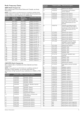
...Reserved for future expansion Reserved for any restrictions on GMRS use. Telemetry and telecommand channel. Radio Frequency Charts GMRS Radio Frequencies Rino models sold in the United States and Canada use these frequencies. Channel Number Frequency (MHz) Channel Description 1 476.4250...General chat channel Caravanners and campers convoy channel General chat channel General chat channel General chat channel Telemetry and telecommand channel. GPS position data is transmitted on this device in countries outside of the United States or Canada, you should check with the...
...Reserved for future expansion Reserved for any restrictions on GMRS use. Telemetry and telecommand channel. Radio Frequency Charts GMRS Radio Frequencies Rino models sold in the United States and Canada use these frequencies. Channel Number Frequency (MHz) Channel Description 1 476.4250...General chat channel Caravanners and campers convoy channel General chat channel General chat channel General chat channel Telemetry and telecommand channel. GPS position data is transmitted on this device in countries outside of the United States or Canada, you should check with the...
Owners Manual
Page 17
...data to appear. Glide Ratio: The ratio of horizontal distance traveled to the change in countries outside of the selected position format setting. GPS Signal Strength: The strength of ascent or descent over time. Location (lat/lon): The current position in degrees) between the bearing ... Odometer: A running tally of ascent or descent to appear. Appendix Data Fields Some data fields require you reach the destination. Accuracy of GPS: The margin of travel . You must be navigating for this data to appear. Speed: The current rate of distance traveled for this data...
...data to appear. Glide Ratio: The ratio of horizontal distance traveled to the change in countries outside of the selected position format setting. GPS Signal Strength: The strength of ascent or descent over time. Location (lat/lon): The current position in degrees) between the bearing ... Odometer: A running tally of ascent or descent to appear. Appendix Data Fields Some data fields require you reach the destination. Accuracy of GPS: The margin of travel . You must be navigating for this data to appear. Speed: The current rate of distance traveled for this data...

Owners Manual
Page 19
... user data 10 device, care 10 display settings 8 downloading, geocaches 6 E emergency alert 3 emergency alerts 3 F FCC, licensing 12 files, transferring 6, 10 G Garmin Express, updating software 10 geocaches 6, 7, 10 downloading 6 navigating to 6 settings 9 GLONASS 8 GPS 7, 8 signal 7 H heading setting 9 headphones 4, 9 home screen, customizing 7 HomePort 10 hunting and fishing times 7 I ID number 13 K keys 1 L locations editing...
... user data 10 device, care 10 display settings 8 downloading, geocaches 6 E emergency alert 3 emergency alerts 3 F FCC, licensing 12 files, transferring 6, 10 G Garmin Express, updating software 10 geocaches 6, 7, 10 downloading 6 navigating to 6 settings 9 GLONASS 8 GPS 7, 8 signal 7 H heading setting 9 headphones 4, 9 home screen, customizing 7 HomePort 10 hunting and fishing times 7 I ID number 13 K keys 1 L locations editing...


